The boardwalk on which you are standing is constructed on what is affectionately referred to by local residents as the "Chief Dock". It is the previous home to the Chief Wawatam (Wa-wa'-tem), a hand-fired, coal burning train-car ferry built by the . . . — — Map (db m130100) HM
Panel 1 — The Life
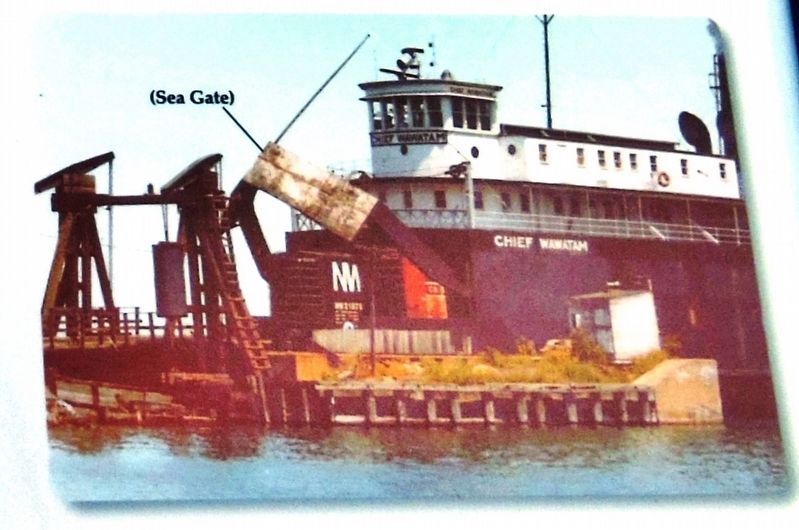
In the years when passenger trains were part of the train service, the Chief's crew consisted of 54 people including "hotel services staff." The Chief ran 24 hours a day. She could carry 348 passengers and had . . . — — Map (db m140007) HM
The Great Lakes have swallowed up over 10,000 ships since the first trading ship was lost in 1679. Storm waves on the lakes are sharper than the roll and swell of ocean waves; a ship may not recover before being struck by another wave.
Lake . . . — — Map (db m139590) HM
The dark debris along the shoreline of this sandy beach is actually tree bark that has washed ashore. How did the tree bark get in the water in the first place?
From the 1870's to the mid 1900's, when the lumber industry was huge in Northern . . . — — Map (db m139492) HM
The dark debris along the shoreline of this sandy beach is actually tree bark that has washed ashore. How did the tree bark get in the water in the first place?
From the 1870's to the mid 1900's, when the lumber industry was huge in Northern . . . — — Map (db m139511) HM
This rudder came from the shipwreck of the William H. Barnum, a wooden steamer lost April 3, 1894. While carrying a cargo of corn the aging Barnum was blocked and cut open by ice. No loss of life occurred.
William H. Barnum Length: 218' • . . . — — Map (db m130126) HM
This is where the Fords' boathouse stood for
many years, jutting out over the cove. Edsel
enjoyed boating of all types, and he owned
an impressive collection of boats. An avid
sailor his entire life, Edsel raced speedboats
competitively as a . . . — — Map (db m206957) HM
"The Dorr" was a 265 foot vessel that was traveling down the St. Clair River with a cargo of coal heading for its port in Detroit in 1927. The boiler overheated and exploded engulfing the stern of the vessel in flames. The captain's attempt to fight . . . — — Map (db m217690) HM
French explorers discovered and named Lake Saint Clair on August 12, 1679. Among the party of 34 men were voyageur Rene-Robert Cavelier, Sieur de la Salle and Roman Catholic friar Father Louis Hennepin. Aboard the Griffon, the first sailing . . . — — Map (db m102458) HM
Only 10 miles from French Fort Detroit (1701), it took 100 years before settlers reached Warren. The Red Run, a branch of the Clinton River was the means that the fur traders and early pioneers followed by canoe.
The Red Run provided the . . . — — Map (db m106084) HM
Only 10 miles from French Fort Detroit (1701), it took 100 years before settlers reached Warren. The Red Run, a branch of the Clinton River was the means that the fur traders and early pioneers followed by canoe.
The Red Run provided the . . . — — Map (db m106087) HM
Only 10 miles from French Fort Detroit (1701), it took 100 years before settlers reached Warren. The Red Run Creek, a branch of the Clinton River was the means that the early pioneers followed by canoe.
The Red Run provided the pathway that . . . — — Map (db m106082) HM
Only 10 miles from French Fort Detroit (1701), it took 100 years before settlers reached Warren. The Red Run Creek, a branch of the Clinton River was the means that the early pioneers followed by canoe.
The Red Run provided the pathway that . . . — — Map (db m106083) HM
Loren Andrus (1816-1901) came to Macomb County from New York State in 1828. He served as an assistant engineer on the survey of the Clinton-Kalamazoo Canal, but gained prominence in agricultural work. In particular he focused on the breeding of . . . — — Map (db m120833) HM
Historic landscape changes within Bowens Creek watershed have severely altered and greatly reduced the quality of its stream and wetland habitats. These impacts are apparent from its unnamed tributaries downstream through Arcadia Marsh to Arcadia . . . — — Map (db m97462) HM
As early as 10,000 years ago, nomadic people were following the bountiful harvests of fish and game the Manistee River provided. By 500 B.C., natives began settling this land, setting up camps and farming.
The lands were controlled by the . . . — — Map (db m97439) HM
The last firm to service the Manistee passenger and package freight business was the Pere Marquette Line Steamers. The companies engaged in this business required extensive dockside facilities to service their clientele. These facilities lined up . . . — — Map (db m97400) HM
For the first 25 years after lumbermen settled in Manistee the river divided the community. People who later became prominent citizens spent their youth ferrying an occasional passenger across the river in canoes. After the Civil War, private . . . — — Map (db m97382) HM
For nearly a hundred years a small building stood across the River which looked like a Dutch windmill without a vane. The building was not a windmill at all, but instead the entrance to a utility tunnel which runs under the River. Today the . . . — — Map (db m97399) HM
An 1818 Treaty allows the United States and Canada to each maintain one warship of limited armament on the Great Lakes. For most of a century the U.S.S. MICHIGAN served as the U.S. warship.
The MICHIGAN was built on the frontier in 1843 at . . . — — Map (db m97434) HM
Following the fur traders into this region came a few adventurous lumbermen looking for saw-mill sites. Interested by what he saw in 1840, Joseph Stronach built a dam and water mill on the swift, natural outlet of Portage Lake.
Soon homesteaders . . . — — Map (db m97445) HM
In these calm but treacherous waters of Lake Superior sixteen lives have been lost since 1961. This memorial serves to honor those lives and the lives of the ones before them. Through this knowledge from this day forward may no more lives be lost. . . . — — Map (db m239999) HM
This monument, representing a World War II submarine, is dedicated to Captain David H. McClintock USN, Marquette; to Captain B. Dulaney Claggett USN, Bethesda, MD; and to the officers and men of submarines Darter and Dace. Their . . . — — Map (db m154129) HM WM
Patience is a virtue we are often told. But impatience spawns innovation and that's how the first iron ore pocket dock came to be. In 1857 Captain George Judson became impatient with the slow transfer of iron ore from trams on the dock to the . . . — — Map (db m216246) HM
The first of the immensely rich Lake Superior iron ore deposits to be discovered and mined were those of the Marquette Iron Range. In 1844 William A. Burt and his surveying party discovered outcroppings of iron ore south of Teal Lake. This area soon . . . — — Map (db m153993) HM
In the 1960's, the introduction of Coho and Chinook Salmon into Lake Michigan was the beginning of great expansion of sport fishing.
In 1964, over 600,000 Coho smolts were stocked in the Platte River and Bear Creek, both tributaries of Lake . . . — — Map (db m98357) HM
The "Abbie" was the last schooner built at the Ludington docks in 1886 for Rasmus Rasmussen. At 88 feet long, 22 feet wide, and with a 6 foot draft, this double-masted, 88-ton schooner was typical of those that sailed the Great Lakes. On most . . . — — Map (db m98353) HM
At least twenty-nine persons died when this vessel sank in Lake Michigan twenty miles off the Wisconsin coast on September 9, 1910. One of the Ludington carferry fleet, the 350 foot S.S. Pere Marquette 18 was traveling from this port to . . . — — Map (db m98338) HM
On November 11, 1940, a severe storm swept the Great Lakes area. As it crossed Lake Michigan ships and seamen fought to reach safety away from its blinding winds and towering seas. Between Big and Little Points Sable the freighters William B. . . . — — Map (db m98333) HM
Called Grande Pointe au Sable by French explorers and traders, Big Sable Point was an important landmark for mariners traveling a treacherous stretch of Lake Michigan shoreline between Big Sable Point and present-day Ludington. In 1855 . . . — — Map (db m41966) HM
S.S. Badger
S.S. Badger is one of fourteen ships that served in the Ludington railroad car ferry fleet. Badger and its sister ship S.S. Spartan, were built in 1952 by the Christy Corporation of Sturgeon Bay, . . . — — Map (db m97277) HM
In memory of the carferry "S.S. City of Flint 32," driven ashore during the Great Armistice Day Storm of November 11, 1940 about 500 feet off shore of this location. Vessel returned to service. — — Map (db m98336) HM
About 1878, John Leathem and Thomas Smith came to this area from Door County, Wisconsin. They cut the towering pines along the west shore of Green Bay and built a saw mill to make lumber and shingles. Over 400 hundred men were employed in the . . . — — Map (db m139042) HM
Stanislaus Chaput, a French-Canadian fur trader sometimes called Louis Chappee, became the first settler at the mouth of the Menominee River in the early 1800s. He fought, along with most of the Green Bay traders, in the British attack on Fort . . . — — Map (db m88829) HM
(Side 1:)
Menominee
French-Canadian voyager Louis Chaput (Chappee) came here during the late 1790s. Chaput, an agent for the American Fur Company, was the first white settler in Menominee, which was named for the Menominee Indians . . . — — Map (db m88831) HM
In memory of
Owen Francis Patrick Hammerberg
Born May 31, 1920 in Daggett, Michigan.
As a United States Navy-World War II veteran ,
Owen was awarded the Congressional Medal of
Honor, posthumously, for heroism in saving the . . . — — Map (db m138504) HM WM
LaPlaisance Bay - the pleasant bay - was named in 1679 by Robert De LaSalle. After the War of 1812, it became part of the United States. In 1820 Maj. John Whipple was appointed keeper of the LaPlaisance Bay lighthouse. April 19, 1825 Col. John . . . — — Map (db m165271) HM
The Native Americans called it Nummasepee (River of Sturgeon), after the great fish that once thrived here. The first French speaking settlers called it Rivière Aux Raisins (River of Grapes) after the many wild grape vines lining its banks. Now . . . — — Map (db m201608) HM
West County Park is one of five Monroe County Parks. This park focuses on providing natural habitat, not only for plants and wildlife, but for the enjoyment of visitors. With its trails, scenic views, and natural landscape which changes from . . . — — Map (db m201610) HM
First land for Sterling State Park was acquired in 1935 as a gift from Monroe Piers Land Company and was named in honor of Wm. C. Sterling, prominent Monroe citizen and first Commodore of the Monroe Yacht Club organized in 1887.
Monroe . . . — — Map (db m200984) HM
Named for the Erie Indians, this was the last of the Great Lakes discovered by white men. The French were exploring the upper lakes as early as 1615, but they avoided the region to the south which was the realm of hostile Iroquois Indians. Then in . . . — — Map (db m107150) HM
Presettlement Times
The area of Michigan known as Monroe was one of our state's earliest settled regions. Its location at the mouth of the River Raisin was strategic to both Native Americans and to the first Europeans who . . . — — Map (db m201328) HM
The port of Monroe two miles east of here is one of the oldest on the Great Lakes.
Only port in Michigan on Lake Erie, and located strategically on its most westerly shore, it was a major point of entry for Michigan settlement and for passage of . . . — — Map (db m171059) HM
WHERE the River Raisin winds through the city of Monroe, it once
flowed over six low head dams (2.5'-3') constructed by the Works
Progress Administration in the 1930s. A habitat restoration project
some 80 years later re-established fish passage . . . — — Map (db m165479) HM
The River Raisin has had a long, rich cultural history. It was known as Nummasepee (River of Sturgeon) by the Native American tribes that first populated the area and used the river for hunting, fishing and transportation. Later, the abundance of . . . — — Map (db m200883) HM
Where the River Raisin winds through the city of Monroe, it once flowed over six low head dams (2.5'-3' high) constructed by the Works Progress Administration in the 1930s. A habitat restoration project some 80 years later re-established fish . . . — — Map (db m200969) HM
Dams installed in the River Raisin in the 1930s have rendered
access to natural habitats for spawning and rearing difficult, if not
impossible to reach for many species of fish in the River Raisin.
Fish passages are considered habitat . . . — — Map (db m201665) HM
Veterans Memorial Park was made possible by the use of
trust funds resulting from civilian defense effort in
Monroe County during World War II and by appropriations
of the Monroe City Commission and the Monroe County
Board of Supervisors.
. . . — — Map (db m200521) HM
In June 1933 two hundred unmarried, able-bodied men between the ages of seventeen and twenty-three, members of the Civilian Conservation Corps, set up camp on Hunt Creek. Soon after, they relocated to this site, which they named Camp Lunden. In 1936 . . . — — Map (db m33293) HM
One quarter mile from this marker is constructed the first underwater fishing reef of its kind in the Great Lakes built entirely of quarried dolomite barged from Wisconsin. This reef is dedicated to public fishing in Michigan. — — Map (db m119656) HM
side 1
By 1897 most of White Lake’s bustling sawmills had given way to cottages and small hotels. Promoters advertised the area’s cool temperatures as relief from the summer heat of cities and drew thousands of people to the area, many . . . — — Map (db m119659) HM
Croton Hydroelectric Plant The Grand Rapids - Muskegon Power Company (a predecessor to today's Consumers Energy Company) built the Croton Hydroelectric Plant in 1906 - 1907. The plant and its 110,000-volt transmission line (the highest voltage . . . — — Map (db m182795) HM
Hardy Hydroelectric Plant Constructed from 1929 to 1931, on a site once known as the Oxbow, the Hardy Hydroelectric Plant was built by Consumers Power Company. The plant was named for George Hardy, a partner in the firm that financed Consumers´ . . . — — Map (db m182797) HM
For thousands of years the Rouge River and later the Mill Pond now known as "Quarton Lake", have been a benefit for many thousands of people. It was a resource that early inhabitants relied upon as part of their survival. In more recent times, the . . . — — Map (db m201385) HM
In the spring of 1953, Eleanor Olney Spicer age 12 was walking her dog, a toy Manchester terrier named Stuart Little, after the children's book, Stuart Little by E.B. White. Suddenly Stuart noticed a small animal and chased it into a drainpipe and . . . — — Map (db m46697) HM
In 1846 Major F. Lockwood built a dam and sawmill on Pettibone Creek northeast of Livingston and Harvey Lake Roads. This sawmill supplied lumber to Highland's earliest settlers until it burned in 1863. In 1867 Chester Chatfield build a cider mill at . . . — — Map (db m20487) HM
The upper mill pond was created in 1846 by damming Pettibone Creek. A mill race entered the pond beneath the road and powered the woolen and woodworking mills. The race for the grist mill left the pond near the dam at the south end of the pond. . . . — — Map (db m125366) HM
Image caption: Chapman Lake Dam
1946 Record rainfall during the months of May and June caused Rudd's Mill Dam (near Clarkston and Kern Roads) to fail, sending a torrent of water down Paint Creek valley. Several dams along the Paint Creek . . . — — Map (db m219866) HM
This picture shows the rear of the Detroit United Railway powerhouse, across Chapman Pond. It was taken southwest of this location, near the Michigan Central Railroad train depot. The pond covered an area of approximately 18.5 acres where the . . . — — Map (db m154225) HM
A flour mill was built on the other side of Paint Creek on Mill Street in 1823, and converted to a paper mill in 1857.
The mill was destroyed in 1875 by a fire started by a disgruntled employee. Owner William Barnes rebuilt the structure with a . . . — — Map (db m179655) HM
Built ca. 1900, the dam was used to generate power for the Western Knitting Mills near Chapman Pond. Remnants of the dam are still visible near the Michigan Central Railroad bridge. In June 1946, torrential rains washed out the earthen . . . — — Map (db m179569) HM
Paint Creek begins in a Brandon Township wetland and flows southeast to Rochester where it empties into the Clinton River. Today a thriving trout stream, the creek was important for waterpower during the nineteenth century. Needham Hemingway dammed . . . — — Map (db m137897) HM
This canal, conceived at the peak of the era of canal-building, was part of Michigan's internal improvements program which was announced in 1837. The Clinton-Kalamazoo Canal would make it possible to cross southern Michigan by boat from Lake St. . . . — — Map (db m118904) HM
Originally a gravel pit operated during the early 1900s by Isaac Boomer, Lake Norcentra has served as a focal point of Rochester College since 1959. Early college leaders derived the lake's name from the first institutional name, North Central . . . — — Map (db m159785) HM
Many founding members toiled long days
in the early automobile factories to gather $500 to buy this site on Sylvan Lake. The first meetings were held in an old shed used for a boat livery. In 1916 the Boat Club was built with rooms for . . . — — Map (db m173460) HM
Wolverine Lake was created in the 1920s through a private damming and inundation project funded by local dentist and developer Howard Stuart. A critical early step in creating the lake involved the construction of the nearby dam, which began in . . . — — Map (db m173416) HM
Here the Petite Pointe Au Sable (little point of sand) juts into Lake Michigan. Increased shipping on the lake started after the Civil War, largely due to the expanding lumber industry. Consequently, this isolated point became the site of several . . . — — Map (db m107009) HM
Graveyard of Ships
The twenty-mile span of Lake Michigan between Little Point Sable, at Silver Lake, and Big Point Sable, north of Ludington, has earned a reputation as the "Graveyard of Ships." Beginning with the loss of the . . . — — Map (db m106970) HM
What is now a park-like shore along the lake was the heart of Pentwater's industrial district during the lumbering era. Today's grass replaced many large neat stacks of newly sawn lumber awaiting shipment. Lumber was the principal outgoing cargo . . . — — Map (db m107195) HM
Michigan's Future: Powered by Renewable Energy
A century ago, Consumers Energy pioneered with a string of hydroelectric plants along Michigan rivers. Today, many of those hydro plants continue to operate and are being joined by a new . . . — — Map (db m182418) HM
Mio Hydroelectric Plant The Mio Hydroelectric Plant was the fourth of six hydros built on the lower Au Sable River between 1909 and 1924 by Consumers Power Company, later Consumers Energy. Completed in 1916, it was the first hydro to pass . . . — — Map (db m216855) HM
The headwaters of five major rivers - Au Sable, Black, Manistee, Pigeon,
and Sturgeon - flow out of Otsego County in every direction, winding
through northern Michigan to eventually reach the Great Lakes. The
abundant forests, wetlands, and open . . . — — Map (db m214855) HM
Until the 1930's the Coast Guard surfmen were shore based, equipped only with oarpowered surfboats to rescue shipwrecked seamen. As steel hulled steam vessels replaced the wooden schooners, more and more wrecks occurred in mid-Lake far away from the . . . — — Map (db m153592) HM
Grand Haven remembers and honors the United States Coast Guard Cutter Escanaba at Escanaba Memorial Park. Based in Grand Haven from 1932 to 1942, the Escanaba embarked on many Great Lakes rescue and ice-breaking missions. The vessel left for service . . . — — Map (db m88819) HM
Grand Haven has been an important base for life-saving on the Great Lakes. In the 1800s, vital transportation on the lakes was challenged by loss of life in storms and accidents. When Congress responded by forming the United States Life Saving . . . — — Map (db m153595) HM
Text on the Front Side:
Shipwrecks and the Coast Guard
In Autumn 1929 raging storms sank four ships on Lake Michigan between Grand Haven and Milwaukee. Two went down with all hands - a total of seventy-seven men. The . . . — — Map (db m88945) HM
The Grand River riverfront has been many things. It was a bustling gateway to Lake Michigan for lumber and shipping in the 1800s. After years of neglect, in the 1950s it gained new life as a vital part of Grand Haven's downtown. In the early 1980s . . . — — Map (db m88811) HM
The 41 foot utility boat (UTB) was the workhorse of the Coast Guard for 36 years, functioning as the service's standard multipurpose near-shore platform. 172 were constructed by the Coast Guard Yard in Curtis Bay Maryland between 1972 and 1978, and . . . — — Map (db m153598) HM
Holland Harbor Lighthouse
The first lighthouse built at this location was a small, square wooden structure erected in 1872. In 1880 the lighthouse service installed a new light atop a metal pole in a protective cage. The oil lantern was . . . — — Map (db m41967) HM
Ottawa Beach is a well - preserved
example of the summer cottage
resorts that developed along the
Lake Michigan shore during the late
nineteenth century. In 1885 the West
Michigan Park Association purchased
eighty acres of land here. In . . . — — Map (db m165345) HM
Originally an Electric Lighting
Plant, this building was
erected less than a decade
after Thomas Edison designed the first
practical dynamo to generate
electricity, which when coupled with
development of the steam-powered
turbine, made the . . . — — Map (db m165346) HM
Holland Harbor (Side 1) When seeking a location for his Netherlands emigrant followers in 1847, the Reverend A.C. Van Raalte was attracted by the potential of using Black Lake (Lake Macatawa) as a harbor. However, the lake's outlet to . . . — — Map (db m67577) HM
Side 1
Winsor McCay (c.1867-1934), a pioneer in cartoon animation, first received acclaim for his artwork as a pupil in Spring Lake's Union School. His blackboard sketch of the 1880 wreck of the SS Alpena inspired a photographer to . . . — — Map (db m88985) HM
This, the fifth largest lake in the world, was the first of the Great Lakes seen by white men. By following the Ottawa River route, Samuel de Champlain in 1615 came to the “Freshwater Sea.” It was half a century before the French fully understood . . . — — Map (db m120725) HM
In 1869, a severe November storm drove the schooner Racer upon
the rocks at Hammond Bay. Fully loaded with iron ore, the Racer
could not free itself and quickly broke apart. It eventually settled
in 11 feet of water.
Today, the . . . — — Map (db m247257) HM
By the 1840s, tens of thousands of settlers arrived yearly in Buffalo, New York, in search
of passage and opportunities further west. Fast, reliable and often opulent steamers,
such as the sidewheeler Albany, carried these passengers across . . . — — Map (db m236525) HM
Starting in 1883, the Fame sailed the Great Lakes for 34 years. Still, it was considered
an unlucky vessel. It sprang a leak less than a year after it was built, ran aground
several times; was struck by lightning twice; and collided with . . . — — Map (db m236522) HM
On October 22, 1881, a fierce storm descended on Lake Huron. Violent northwest
winds and a blinding snowstorm caused havoc. The heavy weather stranded 14 ships
in this area. Remarkably, there was not a single loss of life, and all of the ships . . . — — Map (db m236528) HM
People have traveled on the Great Lakes for thousands of years. During the “Shipwreck Century” (1825-1925)
technology transformed maritime travel and small wooden sailing vessels evolved into giant steel steamers.
Millions of trips were made . . . — — Map (db m236520) HM
Presque Isle Harbor is one of Lake Huron's safest harbors of refuge. Its name comes from this peninsula which, translating from the French, is "almost and island." Indians and Frenchmen portaged across the peninsula to avoid several miles of open . . . — — Map (db m40149) HM
In 1869 the U.S. Congress appropriated $7,500 to build two range lights marking the channel into Presque Isle Harbor. Orlando M. Poe submitted plans in May 1870, and by August the range lights were in operation as seafarers aligned the lights to . . . — — Map (db m120784) HM
Presque Isle, which means “almost an island,” was
named by French voyageurs in the 1600s. It refers to
the peninsula north of the harbor and the surrounding
area. Long before the French arrived, Ottawa people
from the North Channel Islands of . . . — — Map (db m236567) HM
This lighthouse, built in 1870 by Orlando M. Poe, is one of three Great Lakes towers built from the same plans. It replaced the smaller 1840 harbor light. The conical brick tower rises 113 feet from a limestone foundation. The Third Order Fresnel . . . — — Map (db m40062) HM
Lake Huron mariners of the early 1800s considered
Presque Isle the best natural harbor between Port Huron
and Mackinac. Because many ships anchored here for
shelter and cordwood to fuel their boilers, Congress
appropriated $5,000 to build a . . . — — Map (db m236569) HM
Shipwreck Alley.
For more than 12,000 years, people have traveled on the Great Lakes. From Native American dugout canoes to wooden sailing craft and steel freighters, thousands of ships have made millions of voyages on the Inland Seas. The . . . — — Map (db m236831) HM
Like many lighthouses, the Presque Isle lights were in a remote area that was
inaccessible by road. The U.S. Lighthouse Establishment operated boats, called
lighthouse tenders, to bring materials and supplies to these remote outposts.
The . . . — — Map (db m236895) HM
1905 Keeper’s House.
This 1,800-square-foot residence provided housing for additional keepers needed
to run the lighthouse fog signal. In 1905, a crew from Alpena, Michigan, constructed
the house using cement block from a specialized machine . . . — — Map (db m236840) HM
Sanctuary Sentinels.
As the nation’s population and economy rapidly expanded throughout the 19th century, so did the shipping traffic on the Great Lakes. Violent storms, thick fog, shifting sandbars, rocky reefs and heavy vessel traffic made . . . — — Map (db m236876) HM
520 entries matched your criteria. Entries 301 through 400 are listed above. ⊲ Previous 100 — Next 100 ⊳