On June 17, 1579, Captain Francis Drake sailed his ship, Golden Hinde, into the Gulf of the Farallones and the bay that now bears his name. He sighted these white cliffs and named the land Nova Albion.
During his 36 day encampment in California, . . . — — Map (db m221808) HM
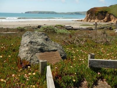
Two plaques make up this marker. This cove is believed by many scholars to be the site of Sir Francis Drake’s California Harbor, where he careened the Golden Hinde to repair a leak received at sea and replenished his ship from 17 June to 25 . . . — — Map (db m73706) HM
In Commemoration of
the landing of Francis Drake
upon these shores June 17, 1579
This cross is erected by
The Sir Francis Drake Association
June 1906 — — Map (db m221787) HM
BCE 2000-1800s
The indigenous Coast Miwok people inhabit Marin County
1769
The Spanish Ship San Carlos becomes the first European vessel to enter San Francisco Bay. The explorers anchor and begin charting the bay
1775
Spanish . . . — — Map (db m232198) HM
In 1775, the packet San Carlos, first known Spanish ship to enter San Francisco Bay, anchored in this cove while her commander, Lieut. Juan Manuel de Ayala, directed the first survey of the bay. Ayala named this island Isla de los Angeles. . . . — — Map (db m143405) HM
Lieut. Juan de Ayala of the Royal Spanish Navy sailed through the Golden Gate on Aug. 5, 1775. He commanded the packet-boat San Carlos, which was the first known ship in the waters of San Francisco Bay. On the 13th day of August, Ayala anchored this . . . — — Map (db m69206) HM
Downtown Tiburon and Harbor
Originally name “Punta de Tiburon” (Shark Point) by Spanish explorers in 1775, downtown Tiburon today is a quaint village in an extraordinary waterfront setting. You’ll find delightful shops and enticing . . . — — Map (db m203883) HM
El Capitan is famous for its massive bulk of largely unbroken rock and its sheer, vertical face soaring 3,000 feet into the air. This monolith is composed of a particularly durable granite, allowing it to withstand the pressures of glaciers and . . . — — Map (db m81949) HM
Who giving voice to silence
benefitted the world
irradiating a new glorious
light upon Italy
I Figli D'Italia
of
Los Banos
Devoted to their great country
of adoption but unforgetful
of their mother country,
in perpetual . . . — — Map (db m41187) HM
Portuguese people from the Azores, as well as mainland Portugal, have a long and honored history in California. The first Europeans to land on the West Coast of the new world were Portuguese. Joao Rodrigues Cabrilho explored the coast in 1542 and . . . — — Map (db m243829) HM
“Striking the river this morning I noticed a cluster of
singular shaped rocks sticking up in spires of a conical
shape 20 to 30 feet high” - Andrew Lopp Murphy, Sep 26, 1849 — — Map (db m113025) HM
“We crossed the creek here running between high banks,
and drove a short distance down the north west side
and encamped” — Elijah Preston Howell, Sep 6, 1849 — — Map (db m113037)
“My shoes are giving out and I have no others. Left one of
them and the other is barely on...At our noon camp I made
some moccasins of cloth” — Joseph Stuart, Sep. 28, 1849 — — Map (db m113024) HM
"We now call this cr. a river, but we do not know what it is. We begin to hear ... that we are near the Sacramento Valley" - Elijah Preston Howell, Sep 8, 1849 — — Map (db m147426) HM
"A few hundred yards N. W. of our camp, a tall, symetrical [sic] butte, or isolated mountain, rises from the level plain, like a tent." - J. Goldsborough Bruff, Oct 6, 1849 — — Map (db m147884) HM
This is the location of the junction of the original 1846 route of the Applegate Trail and the 1853 realignment of the trail as laid out by road engineers from Siskiyou County. The original route goes due east from this point and its traces are no . . . — — Map (db m152261) HM
The 1846 Applegate Trail, also known as the South Road to Oregon, lies behind this sign and heads westward along the banks of Fletcher Creek. It leaves Fletcher Creek after about two miles and then swings around the southern flank of Blue Mountain. . . . — — Map (db m152283) HM
... Decent [sic] to the lake ... Night brought us to the end of the lake ... We laid up on a mountain brook where the roads forked ... One branch going to Oregon, the other to California."
Alonzo Delano, August 28, 1849 — — Map (db m147424) HM
"Four miles to a beautiful little stream of pure cold water coming from the mountains to our left and emptying into Goose Lake ... Camped there ...Found plenty of ripe plums on the neighboring mountain sides." - Andrew Murphy, Sep 23, 1849 — — Map (db m147338) HM
"We arrived at the foot of the summit ridge, the top of which lay one mile distant ... Up we ascended, slowly but surely, by the toilsome climbing of the teams and by lifting of the members. ... at the wheels." - William Swain, Oct 11, 1849 — — Map (db m147406) HM
"Passing over the summit, which is a very narrow ridge, a broad,deep valley ... presented itself to our view, far below us ... We immediately descended the mountain, which on this side, is fearfully steep" - Amos Batchelder, Sep 25, 1849 — — Map (db m147407) HM
"Trees hundreds of feet high and 4-5-6 feet in diameter ... We can drive anywhere among the trees. Only the ground is covered with cobble stones" - E. W. Brooks, Sep 1, 1849 — — Map (db m147888) HM
"Camped at a magnificent spring of fresh cold water,
which we called Goff's Spring, in honor of the
newly elected lieutenant of the company."
-Levi Scott, South Road Exploring Party, 1846 — — Map (db m151903) HM
This trail was blazed by Peter Burnett in 1848 from Oregon City, Oregon Territory to the California gold fields. The route followed the Applegate Trail south and eastward to Tule Lake. It then struck southward probably following an earlier trail . . . — — Map (db m147839) HM
"We followed the Applegate Route to Klamath Lake [Tule Lake], where we left that road and took a southern direction. Thomas McKay, myself, and five others ... Went on in advance of the wagons to discover the best route" - Peter Burnett, Oct 1848 — — Map (db m147564) HM
"The water [at Copic Bay] being so bad, we drank very little, and left early next morning [over a prairie]." - Peter Burnett, Oct 1848 — — Map (db m147841) HM
Burnett's Road - Hunters skirted the lava fields to the west as they headed southerly. They crossed dry lake, which had only scattered ponds of water, and entered an area of scattered brush and rocky ridges. — — Map (db m147844) HM
On January 27th, a cold winter day in 1844, Captain John C. Fremont and his guide Kit Carson led a small band of half-starved men west past this point. They were in search of the fabled Buena Ventura River, which they believed would give them easy . . . — — Map (db m49887) HM
The name of this community honors LeRoy Vining. In 1852 Lt. Tredwell Moore and soldiers of the 2nd Infantry pursued Indians of Chief Tenaya’s tribe from Yosemite across the Sierra via Bloody Canyon. They took back mineral samples and a prospecting . . . — — Map (db m49967) HM
extended from Bishop south for 100 miles. The valley was inhabited by Indians for many years. Joseph Walker in 1833 was the first white man to discover the valley. In 1845 John C. Fremont named the valley, a river and a lake, after Richard Owens, an . . . — — Map (db m50058) HM
In the aftermath of the California Gold Rush, many newcomers decided to put down roots in the West. But would-be farmers and ranchers soon found that rancho grants had claimed much of the best and most accessible agricultural valley and grazing . . . — — Map (db m197536) HM
5-6 March 1976
The mochila was passed between the San Luis Obispo and Monterey County contingents at this site on this date commemorating
The United States Bicentennial — — Map (db m64426) HM
Lt. Colonel Juan Bautista De Anza by decree of Carlos III of Spain. Led an expedition to this site the mission being to colonize the San Francisco Bay Area. De Anza Expedition 1775 - 1776 — — Map (db m83335) HM
On December 10, 1769, the Portola Crespi Expedition from Mexico erected a cross on this hill to signal its long-overdue supply ship San Jose. A message at the cross stated that they were suffering great privation and were returning to San Diego. The . . . — — Map (db m68862) HM
The legend of “the mustard seed trail” is rooted in the Portola expedition which travelled through the Ohlone tribal lands with a wagon containing sacks of mustard seeds. These seeds were spread behind them as they travelled north in the winter, . . . — — Map (db m64255) HM
Lt. Colonel Juan Bautista de Anza by decree of Carlos III of Spain led an expedition to this site – The mission being to colonize the San Francisco Bay Area.
In the center of the marker is a circular motif, designed by Doris . . . — — Map (db m61384) HM
Lt. Colonel Juan Bautista de Anza by decree of Carlos III of Spain led an expedition near this site – the mission being to colonize the San Francisco Bay Area. — — Map (db m64415) HM
This date marks the 400th anniversary of the naming of Monterey Bay by Gen. Sebastián Vizcaíno, commissioned by Don Gaspár Zúñiga y Acevedo, Count of Monte Rey. Near this place, called Acasta and Hummukul by the Ohlone/Constanoan Esselen Nation, Fr. . . . — — Map (db m68622) HM
Captain Don Gaspar de Portola
Of the army of King Carlos III of Spain. First governor of California, 1768-1770. With Father Junipero Serra founded Monterey on June 3, 1770.
Donated by H. M. King Juan Carlos of Spain to the City of Monterey . . . — — Map (db m63525) HM
Lt. Colonel Juan Bautista De Anza by decree of Carlos III of Spain, lead an expedition to this site – the mission being to colonize the San Francisco Bay Area.
In the center of the marker is a circular motif, designed by Doris . . . — — Map (db m63230) HM
On June 3, 1770, near this spot, Don Gaspar de Portolá, Soldier, Explorer, Patriot of Spain, founded the Presidio and settlement of Monterey. — — Map (db m135033) HM
A native of Mexico de Anza left Tubac, Culiagan October 23, 1775 with a party of 240 together with horses, mules and beeves. Arrived Monterey March 10, 1776 with loss but one person. Journey of 1600 miles made under conditions of drought, snow and . . . — — Map (db m63566) HM
At Monterey, June 3rd
1770
the ceremony of taking possession
of California for Spain was enacted by
Father Junipero Serra
under the shade
of this tree. — — Map (db m63259) HM
□ Look out upon these waters.
□ Their recorded history began when Juan Rodriguez Cabrillo sighted the "Bay of Pines" on Nov. 17, 1542.
□ Sebastian Viscaino was first to touch land Dec. 16, 1602. He claimed the land for . . . — — Map (db m30347) HM
In 1542, the explorer Cabrillo called this point of land Cabo de Nieve - Cape Snow- to describe the white landscapes before him. No one's sure what he saw. In 1774, Tomás de la Peña, a missionary, gave this western-most point on the Monterey . . . — — Map (db m83330) HM
In the winter of 1769, the Spanish expedition in
search of Monterey Bay, under the command of
Don Gaspar de Portola and Father Juan Crespi,
erected a cross on or near this site and left
the following message: “The land expedition . . . — — Map (db m68863) HM
Lt. Colonel Juan Bautista de Anza by Decree of Carlo III of Spain led an expedition near this site — the mission being to colonize the San Francisco Bay Area
In the center of the marker is a circular motif, designed by Doris Birkland . . . — — Map (db m27188) HM
James Clyman - Trapper and Explorer. Prominent in opening the Far West. He was with Jedediah Smith in 1824 at South Pass. Prepared the way for the pre-Gold Rush pioneers. Settled in Napa County in 1848. — — Map (db m54549) HM
The legendary Paiute leader; friend and guide; breveted a “Captain” by John C. Fremont; gave his name to this valley, river and town: died near Payton, Nevada, in 1860. — — Map (db m60320) HM
On October 28, 1846 the six covered wagons brought west by George and Jacob Donner and their families halted here for repairs. By March of 1847 one half of the party of 22 adults and children had died of starvation and cold. They came west seeking a . . . — — Map (db m60507) HM
For thousands of years, people have crossed the Sierra Nevada near this place called Donner Pass.
Traveling by foot, wagon, train or automobile, the journey has always been challenging.
By Foot
Long before it’s “discovery” . . . — — Map (db m23571) HM
The Stephens – Townsend – Murphy Party, with guidance from old Caleb Greenwood and Chief Truckee, brought their wagons up the Truckee River bed and on Nov. 25, 1844 191 days out of Council Bluffs, Iowa passed this point and crossed the . . . — — Map (db m60305) HM
This old wood-burning engine was used in early-day borax mining on the desert in Death Valley and was brought here in 1941. It was a distinct improvement over the 20-mule team that used to haul borax from the mines, but was still hot, miserable work . . . — — Map (db m192482) HM
In 1906 guidepost bells were placed along the El Camino Real to guide early travelers and to preserve this historic route which linked California's missions beginning in 1769. — — Map (db m204334) HM
Where Richard Henry Dana Jr. threw the hides purchased at the old mission to the beach below to be loaded and shipped to Boston nearly a hundred years ago. — — Map (db m189509) HM
"The Only Romantic Spot on the Coast" Dana Point is named after Richard Henry Dana, Jr. a nineteenth century sailor. Dana called this area "the only romantic spot on the coast," words of admiration that would forever link his name with this . . . — — Map (db m183014) HM
The natural cove that became Dana Point Harbor was an anchorage for trading ships in the 1800s. A re-creation of the brig Pilgrim that brought namesake Richard Henry Dana is moored at the west end. — — Map (db m189516) HM
When the Spanish army and missionaries came to California in 1769, they made a route, El Camino Real, for travel between missions they established, stretching from San Diego to Sonoma. In the early 1900s, a group of women's clubs, among others . . . — — Map (db m189668) HM
1769 - Portola Expedition enters what is now Orange County.
1821 - California under Mexican Rule.
1842 - Rancho Canada de los Alisos granted to Don Jose Serrano; future site of Heritage Hill Historical Park.
1850 - California . . . — — Map (db m195046) HM
It was near this site on July 22, 1760 that Captain Gaspar de Portola joined by 63 men and two priests, stepped into history by crossing the Arroyo Trabuco during the first Spanish expedition into Alta California. Today, June 8, 1992, the County of . . . — — Map (db m196167) HM
It was near this site on July 22, 1760 that Captian Gaspar de Portola joined by 63 men and two priests, stepped into history by crossing the Arroyo Trabuco during the first Spanish expedition into Alta California. Today, June 8, 1992, the County of . . . — — Map (db m198396) HM
In 1769 Gasper de Portolá led a group of Spanish soldiers on a thousand-mile march from Baja California to San Francisco. His purpose was to locate the ports of San Diego and Monterey and to establish a series of churches and military posts. The . . . — — Map (db m188706) HM
1870
On September 10th, Captain Samuel S. Dunnels entered Newport Bay for the first time on the steamship Vaquere. The landing was below this site and designated "Newport". The McFadden brothers operated a regular shipping service between . . . — — Map (db m196756) HM
On September 22, 1779, Juan Bautista de Anza, with a party of over 200 emigrants and soldiers, set out from the presidio at Tubac, Mexico, to found San Francisco. His party reached the San Gabriel Mission on January 4, 1776, after many miles of . . . — — Map (db m224291) HM
Portola camped on bank of Santa Ana River in 1769. Jose Antonio Yorba, member of expedition, later returned to Rancho Santiago de Santa Ana. El Camino Real crossed river in this vicinity. Place was designated Santa Ana by travelers, and known by . . . — — Map (db m50302) HM
San Clemente Island is the southernmost of the eight California Channel islands. The 56 square miles island received its named in November 1602 when Spanish explorer Sebastian Vizcaino sailed passed it while mapping the region. It represents . . . — — Map (db m190450) HM
As Governor of Baja California Portola was the military leader of the Spanish expedition into Alta California, which camped near the future site of the Mission on July 23, 1769. — — Map (db m199165) HM
Yorba was one of the 66 Catalonian volunteer soldiers in the Spanish expedition, and later built the Miguel Yorba and Domingo Yorba Adobes. — — Map (db m199166) HM
While reading this plaque, you are facing the historic El Camino Real, also known as "the King's Highway or "The Royal Road".
Originating in 1769, the trail got its name from the Spanish monarch who directed the establishment of a chain of . . . — — Map (db m188641) HM
A Spanish soldier station at San Juan Capistrano in the late 1700s. He was awarded a land grant in the San Juan Capistrano Area which remained in his family for 10 generations. — — Map (db m199168) HM
Ortega was the scout who blazed the trails for the 1769 Spanish expedition from San Diego to Sonoma, and discovered San Francisco Bay. — — Map (db m199145) HM
The site before you and the surrounding areas have been utilized by the Juaneno Indians (Original inhabitants of the Capistrano Valley). Mission San Juan Capistrano, and residents of this community in a variety of capacities over the years. . . . — — Map (db m188549) HM
Situated on this hill, located between the two rivers of the Capistrano Valley, is this sacred and consecrated ground. From this hilltop, the ocean, Mission, and town can be seen. It is a perfect resting place for San Juan Capistrano's historic . . . — — Map (db m199141) HM
Sergeant Jose Francisco Ortega was the chief Scout for the Gaspar de Portola exploratory expedition in 1769. While exploring a route for Portola on their way to Monterey Bay, he was the first non-Native American to discover Capistrano Valley. Nearby . . . — — Map (db m188649) HM
Dedicated - June 18, 1950 A Memorial to Richard O'Neill California pioneer (1850) Alice O'Neill, his wife Jerome O'Neill Richard O'Neill Jr.
El Trabuco - Mission Viejo 1769 - Captain Gaspar de Portola, Padre Crespi and soldiers . . . — — Map (db m185388) HM
This monument dedicated to the memory of
James P. Beckwourth
Born in Virginia, the son of a Southern planter and a negro slave, Beckwourth was a trapper, scout and mountain man. He explored the west with Jim Bridger, Kit Carson and Peter . . . — — Map (db m56409) HM
This marker is made up of four panels. They are presented left to right.
Agriculture in Sierra Valley
A few years after James Beckwourth settled on what he called the War Horse Ranch just west of here in 1852, more ranches and farms . . . — — Map (db m66179) HM
On March 16, 1774, Juan Bautista de Anza, Indian fighter, explorer, and colonizer, led through this pass (named by him San Carlos) the first white explorers to cross the mountains into California. The party traveled from Tubac, Arizona, to Monterey, . . . — — Map (db m143392) HM
On January 1, 1776, the first party of colonists to come overland to the Pacific Coast crossed the Santa Ana River south of this marker and camped between here and the river. Recruited in the presidios of Sonora, Mexico, and led by Lt. Col. Juan . . . — — Map (db m50995) HM
In memory of John Guthrie McCallum
January 1985
The wild and open spaces of the desert were home to the McCallum Family who settled in the Coachella Valley in 1884. Preservation of the pristine desert lands protected in the Coachella . . . — — Map (db m214106) HM
Site of Cahuilla Indian Village of Wanapiapa, home of the Wanakik Lineage. Visited by Jose Romero Expedition exploring overland route from Sonora to California 1823. Eastern boundary of Rancho San Gorgonio. Adobe south of highway served as Stage . . . — — Map (db m126302) HM
Born, Charlestown, N.H. Aug. 24, 1778; Died Franklin, Mar. 6, 1865 Last surviving member of the Lewis and Clark Expedition. He kept a journal and gave valuable service as a gunsmith. — — Map (db m10520) HM
Alder Springs, south of this point, marks the Old Coloma Road, running between Sutter’s Fort and Culluh-mah (Coloma). Established in 1847, this road was used by James W. Marshall in January 1848 to bring the first gold from Sutter’s Mill to the . . . — — Map (db m11901) HM
On the south bank of the American River near this spot General John A. Sutter landed August 12, 1839 and founded New Helvetia which is now Sacramento City. Also on this river in the mill race at Coloma fifty miles east of here on January 24, 1848 . . . — — Map (db m94906) HM
Dedicated to the Memory of
Father Junipero Serra
1713 - 1784
the first Franciscan missionary
to whom California owes an
everlasting tribute – he brought
civilization to our land and in deed
and character he deserves a foremost
place in . . . — — Map (db m14817) HM
Even though California and the Sacramento Valley were remote to the rest of the world, the area was a focus of exploration in the first half of the 19th century by the Spanish, Americans, British, French, Germans, Russians, and many others. Gabriel . . . — — Map (db m229800) HM
By the late 1830s, so many different nations had explored and settled in California that the Mexican government feared it would lose region. The British and French had arrived both by land, from Canada, and by sea; the Russians had settled along the . . . — — Map (db m229802) HM
Sutter employed a group of Mormons, under the supervision of James Marshall, to build a lumber mill on the American River at Coloma. The men worked on building a tailrace which would guide water from the mill back to the river. By day the men . . . — — Map (db m229803) HM
The Spanish Missionaries’ quest for mission sites led to their exploration of the river. However, no missions were ever built in this region. The first known sighting was in 1774 by Fray Juan Crespi and Pedro Fages. By 1808, Gabriel Moraga gave the . . . — — Map (db m25880) HM
In 1775 and 1776 Lt Colonel Juan Bautista de Anza, Father Pedro Font along with 240 colonists, soldiers and others traveled 1,800 miles from Sonora, Mexico to Monterey, California. Anza then led a smaller party of soldiers to choose sites for the . . . — — Map (db m213060) HM
Lt. Colonel Juan Bautista de Anza by decree of Carlos III of Spain led and expedition near this site – The mission being to colonize the San Francisco Bay Area. — — Map (db m15366) HM
4087 entries matched your criteria. Entries 301 through 400 are listed above. ⊲ Previous 100 — Next 100 ⊳