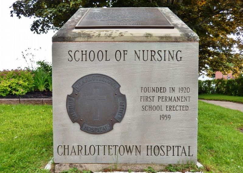
On Haviland Street at Sydney Street, on the left when traveling north on Haviland Street.
This memorial marks the location of The Charlottetown Hospital (1879-1982) The Charlottetown Hospital School of Nursing (1920-1971) and The School of X-ray Technology (1953-1971) The hospital, founded by Bishop Peter McIntyre and The Sisters of . . . — — Map (db m149594) HM
On Water Street (Prince Edward Island Route 1) at Grafton Street, on the left when traveling north on Water Street.
English: The City of Charlottetown was incorporated in April 1855. The present boundaries of the city are a result of an amalgamation of six surrounding communities in 1995. The City is governed by a mayor and 10 councilors. Its . . . — — Map (db m149908) HM
This double tenement, built by John and Elizabeth Gainsford, became a landmark in a city largely built of wood. It is Charlottetown’s oldest surviving brick building. For many years the east side was the home of John Iags, editor of “The . . . — — Map (db m104833) HM
On Prince Street close to Water Street, on the left when traveling south.
English:
The Hillsborough River watershed, totaling over 350 square kilometres, is the largest river system in Prince Edward Island. As a river highway, it provides a direct link to our rich human heritage, from the Mi’Kmaq who depended on . . . — — Map (db m80187) HM
On Water Street (Prince Edward Island Route 1) at Grafton Street, on the left when traveling north on Water Street.
English: The Port of Charlottetown has a history of wooden shipbuilding, local ferry wharves and shipping connections with the world. Family connections with the Westcountry of England made it a prime destination. Shipbuilders, . . . — — Map (db m149906) HM
On Water Street (Prince Edward Island Route 1) at Grafton Street, on the left when traveling north on Water Street.
English: In 1768 Charles Morris, a Halifax Surveyor, was directed to lay out the town under the directions of the Board of Trade and Plantations in London. Later the Island's first British Governor, Walter Patterson, through his . . . — — Map (db m149900) HM
On University Avenue at Douglas Street, on the right when traveling north on University Avenue.
This location became a common burying ground in 1784. There may have been an earlier site closer to the waterfront, but its location has been lost. In an early survey of Charlottetown, there was a large commons, and this site was part of it. In . . . — — Map (db m269373) HM
On University Avenue at Douglas Street, on the right when traveling north on University Avenue.
[English]
This burying ground served the City for most of the Province’s colonial period. Charlottetown was a collection of a few dozen dwelling places when the site was set aside as a burying ground. The mortal . . . — — Map (db m269385) HM
On Grafton Street at Water Street ( Route 1), on the right when traveling east on Grafton Street.
English: The railway played a major role in shaping Canada and it played an important role in the development of Prince Edward Island. The sod was turned for the PEI Railway on October 5, 1871 just north east of where you are . . . — — Map (db m149897) HM
On Water Street (Prince Edward Island Route 1) at Grafton Street, on the left when traveling north on Water Street.
English: The site of Charlottetown was chosen by Surveyor General Samuel Holland on his survey of St. John's Island. Now called Prince Edward Island, it was once called Epekwitk, which means "lying on the water", by the . . . — — Map (db m149904) HM
Near Richmond Street close to Great George Street.
English:
Born in Charlottetown, Haviland was called to the Prince Edward Island bar in 1846. He represented Georgetown in the legislature (1847-70), serving successively as Colonial Secretary, as Speaker, and as Solicitor-Genera1. As a . . . — — Map (db m80268) HM
On Prince Street near Water Street, on the left when traveling south.
English:
The Prince Edward Island Railway brought Islanders together, put them to work, and even made them Canadians.
Before the Railway was built on Prince Edward Island you could live within ten miles of another village and hardly . . . — — Map (db m80185) HM
On Grafton Street at Water Street ( Route 1), on the right when traveling east on Grafton Street.
English: The Railway Station stands not far from where you now stand. The air was once full of steam, the sound of train whistles and shunting rail cars. It was a busy place with the Western train, the Eastern train and the Murray . . . — — Map (db m149898) HM
On Prince Street at Prince St, on the right when traveling north on Prince Street.
Trinity Church
was founded in 1778 by
Benjamin Chappell,
friend of John Wesley.
The congregation continued in
the Wesleyan Methodist
tradition until 1925 when,
choosing the name Trinity,
it became a founding
congregation of the
United . . . — — Map (db m201326) HM
Near Richmond Street close to Great George Street.
English:
Born at Bedeque, Prince Edward Island, Pope was admitted to the bar in 1847, became Colonial Secretary in 1859, was elected to the Legislative Assembly representing Queen's County in 1863 and continued to serve in the Assembly . . . — — Map (db m80272) HM
On Great George Street at Lower Water Street, in the median on Great George Street.
Work of art by Jules LeSalle
In recognition of the 150th anniversary of the 1864 Charlottetown and Québec conference, which led to the creation of Canada, bronze statue of two Fathers of Confederation were commissioned, one for . . . — — Map (db m202748) HM
Black Islanders: Four Centuries and Counting...
For almost 300 years, Black Islanders have existed on Epekwitk (PEI). In 1732, a small group of enslaved people were brought
to French-occupied PEI, then known as Isle Saint-Jean. . . . — — Map (db m259946) HM
On Friday, June 5, 2020, the largest rally in PEI’s history took place. Organized by the Black Cultural Society of PEI, thousands marched through downtown Charlottetown to support racial justice and Black Lives Matter. A week later, Gord . . . — — Map (db m259937) HM
On Grafton Street, on the left when traveling north.
In honor of all women who served in the armed forces
En l'honneur de toutes les femmes qui ont servi dans
les forces Canadiennes — — Map (db m260175) WM
Canadian Merchant Navy
Marine Marchande Canadienne
1914-18 1939-45 1950-53
The life line of the whole world
Pour la survie du monde libre — — Map (db m260166) WM
Charlie and Harrison Ryan, brothers from Charlottetown, enlisted in the Second World War and served overseas for more than four years with the Royal Canadian Medical Corps. Descendants of David and Keisha Shepard, they are part of one of the . . . — — Map (db m259939) HM
On Great George Street near Great George and Water Streets.
In this milieu in the late summer of 1864 came two important events - the Slaymaker and Nichols Olympic Circus (the first such visit in over twenty years), and the Charlottetown Conference with delegates who arrived from the Maritimes and Upper and . . . — — Map (db m260211) HM
On Great George Street near Great George and Water Streets.
After the end of the Seven Years War (1756-1763) French De St. Jean was placed under the control of the British who, in 1763 promptly remained their new colony St. John's Island. The next year the king surveyor Captain Samuel Holland, conducted a . . . — — Map (db m260212) HM
Building Links Between Capitals, Between Canadians
Confederation Birthplace Commemorative Park was built in honor of a nation-building conference held in Charlottetown in 1864. Many other sites across Canada commemorate . . . — — Map (db m260167) HM
Cutting Edge Design
Unlike many New World settlements, Charlottetown was planned before it was built. Importing Old World amenities and new theories of design, the town plan was a chance for Britain to learn from past mistakes. . . . — — Map (db m260171) HM
Near Richmond Street close to Great George Street.
English:
Born in Charlottetown and called to the bar in 1831, Palmer was a member of the legislature (1835-60), and of the Legislative Council (1860-73). Between 1848 and 1873 he held several cabinet posts, including that of . . . — — Map (db m80270) HM
On Richmond Street at Queen Street, on the left when traveling north on Richmond Street.
Evolution of Queen Square
In 1771 Queen Square looked more like
an overgrown pasture than a prim
public square. Nearly bankrupt, the
infant colony had little money to spend
on public buildings for the site. As a
result, the . . . — — Map (db m260183) HM
Fred Shepard, like many islanders, went to the mainland to find work. Originally from Cardigan Head, he was working construction in Montreal around 1941 when tragedy struck. Fred was seriously injured in a workplace accident that broke . . . — — Map (db m259921) HM
At 27, Charlottetown’s George Godfrey was considered old to start a professional career. In 1879, he debuted in Boston and knocked out three heavyweight fighters. Despite his late start, George had an illustrious 16-year career, . . . — — Map (db m259941) HM
On Terry Fox Drive near Kent Street, on the left when traveling north.
Government House
In 1833-34, local contractors Isaac Smith, Henry Smith, and
Nathan Wright built this finely-proportioned frame structure
of neo-classical style as the official residence of the Lieutenant
Governor of Prince . . . — — Map (db m289817) HM
Myrtle “Dolly” Gallant was determined to be a nurse. Denied entry to Charlestown nursing school because she was Black, Dolly studied at St. Martha’s in Antigonish. Graduating with honors in 1946, Dolly returned home to work at . . . — — Map (db m259943) HM
New Brunswick Entered Confederation in 1867.
Le Novea-Brunswick Fait Partie De La Confederation
Depuis 1867.
Limestone Containing Archeaozoon Acadiense/Calcaire Ave Archeozoon Acadiense. — — Map (db m260173) HM
On Great George Street near Great George & Water Streets.
1. George Coles (1810-1873)
Born in Charlottetown, Coles operated a brewing and distilling business, which was to be of excellent advantage during the Charlottetown Conference. He became a Liberal member for the First District of Queens . . . — — Map (db m260373) HM
On Queen Street at Sydney Street, on the right when traveling north on Queen Street.
Pub Politics
Imagine your political leaders passing laws in the local pub. Until the first public building was erected in Queen Square in 1812, this was exactly where the Island's legislature met to discuss important issues of the . . . — — Map (db m260192) HM
Quebec entered the Confederation in 1867.
French:
Le Quebec fait partie de la Confederaton Depuis 1867.
Anorthosite/Anorthosite — — Map (db m260177) HM
Robert “Allie” Hennessey, seen here with his parents, James and Hazel, tried his luck at boxing in the 1950s. Affectionately called “Dada” by his daughter, Linda, she recalls how his career consisted of only one fight which ended in a . . . — — Map (db m259924) HM
The distinctive spelling of Robert Allen Shepheard’s surname on First World War recruitment papers adds to the number of spellings of this historic Black Islander name, passed down since David and Keisha Shepard arrived in the 1780s as . . . — — Map (db m259935) HM
Since 1860, when the Shaw family began accepting paying guests In their home, this hotel has occupied a prominent place in Prince Edward Island’s tourism industry. Over the last 19th and early 20th centuries, the original farmhouse was enlarged and . . . — — Map (db m259914) HM
The Bog neighborhood physically came to an end in the early 1900s with Charlottetown’s decision to redevelop the area, but the community story continued. Some families had already moved to the Boston States to work, establishing a new branch of the . . . — — Map (db m259918) HM
On Great George St near Great George and Water Streets.
The three Maritime colonies of Great Britain, Nova Scotia, New Brunswick, and Prince Edward Island, had long considered the possibility of union. By the early 1860s, however, there was sufficient concern over an American attack, after the conclusion . . . — — Map (db m260196) HM
The Prince Edward Island Memorial Fountain
Dedicated 18 September 2005
Honouring Prince Edward Islanders who have volunteered to serve their country and community in dangerous professions as armed forces members, police, . . . — — Map (db m260180) WM
Summertime on PEI wasn’t complete without a trip to the Exhibition. Families like Dolly, Ann, and Charlotte enjoyed the sights, sounds, and smells of this highly anticipated event. Which took place every August. Exhausted little . . . — — Map (db m259933) HM
Robert, Lemuel, and James Shepherd, originally from Cardigan, headed to the Klondike seeking riches. Unlike the masses, they struck gold! Returning home for a visit, the brothers gifted family members some gold nuggets and their younger . . . — — Map (db m259930) HM
The West End Rangers, formed in 1899, was the only PEI team in the Colored Hockey League. Based in Charlottetown’s Bog neighborhood, the Rangers were known for their strength and skill. In 1901, they easily beat the visiting Truro . . . — — Map (db m259928) HM
Island ships were traditionally built to export agricultural goods and lumber. By the early 1800s, Islanders learned they could make more money selling ships than moving barrels of fish and produce across the Atlantic. Shipyards soon . . . — — Map (db m260181) HM
On Grahams Road (Prince Edward Island Route 20) at Route 6, on the right when traveling north on Grahams Road.
Lucy Maud Montgomery, daughter of
Hugh John Montgomery and Clara
Woolner MacNeill, was born in this
house on November 30, 1874. — — Map (db m138186) HM
On Cavendish Road (Prince Edward Island Route 6) at Church Hill Road, on the left when traveling east on Cavendish Road.
Dedicated to the men
and women of this
community who
served their country
in World War 1, World
War II, and the Korean
War and in grateful
tribute to those
who made the
supreme sacrifice.
W.W. II
W.O. II Fredrick L. Bulman
Pte. . . . — — Map (db m139243) WM
On Harbourview Drive, on the right when traveling west.
*Mi'Kma'Ki Indian camps have been found around Rustico Bay dating back 6000 years.
*Jacques Cartier sailed along this north shore in 1534.
*Rene Rassicot fished off Rustico in 1729 & gave the area its name.
*Acadians first settled North . . . — — Map (db m289820) HM
Near Hache Gallant Drive 1.2 kilometers east of Route 19, on the left when traveling east.
English: Working out of Fort Amherst between 1764 and 1765, Captain Samuel Holland, an engineer, directed a small team to produce an accurate survey of every inch of St. John's Island. It was the first phase of a major survey of . . . — — Map (db m151802) HM
Near Hache Gallant Drive 1.2 kilometers east of Route 19, on the left when traveling east.
English: ”It is three years since the last refugee arrived on the island. They had to endure heavy losses and great hardship in getting here, and on arrival, they found themselves so to speak destitute… My Lord, unless you . . . — — Map (db m151801) HM
Near Hache Gallant Drive 1.5 kilometers east of Route 19.
English: With Island history as your backdrop, you're looking out at Charlottetown Harbour, the Hillsborough River, Governors Island, and the bluffs of Keppoch. In the summertime, this waterway hosts an abundance of . . . — — Map (db m151792) HM
Near Hache Gallant Drive 1.2 kilometers east of Route 19, on the left when traveling east.
English: Michel Haché-Gallant and Anne Cormier were the first Acadians to join the French colonists at Port-la-Joye. They arrived in 1720 from Beaubassin with four of their children. By 1730, eight Gallant children owned properties . . . — — Map (db m151797) HM
Near Hache Gallant Drive 1.2 kilometers east of Route 19, on the left when traveling east.
Français:Première famille acadienne établie en permanence à L’Île-du-Prince-Édouard Ancêtres des familles Gallant et Haché du Canada et des États-Unis arrivés à Port-La-Joye en 1720 Monument érigé en 1965 par leurs . . . — — Map (db m151800) HM
Near Hache Gallant Drive 1.2 kilometers east of Route 19, on the left when traveling east.
English: This timeline presents events that helped shape the history of Port-la-Joye—Fort Amherst, Prince Edward Island and Canada. Port-la-Joye was an imperial outpost for France for 38 years. For another ten years, Fort . . . — — Map (db m151804) HM
Near Hache Gallant Drive 1.2 kilometers east of Route 19, on the left when traveling east.
English:We are in Port la Joye, one of the most beautiful harbours that the eye can behold. —Louis Denys de la Ronde, November 6, 1721 In 1720, three hundred men, women and children were brought from France to . . . — — Map (db m151803) HM
Near Haché Gallant Drive 1.2 kilometers east of Route 19, on the left when traveling east.
English:
From 1720 to 1768 this site was an important colonial base, first for France and later Great Britain. One of the first permanent French settlements on the island, Port-la-Joye served as the seat of colonial government for . . . — — Map (db m139447) HM
On Prince Edward Island Route 19 just south of Rogers Passage Lane, on the left when traveling south.
English:
In 1764 the British government decided to undertake a systematic survey of its North American territory, recently enlarged in the war with France. For this purpose Captain Samuel Holland was put in charge of the northern . . . — — Map (db m139436) HM
Near Hache Gallant Drive 1.2 kilometers east of Route 19, on the left when traveling east.
English: Lieutenant-Colonel Andrew Rollo arrived with a force of five hundred soldiers and took possession of Port-la-Joye on behalf of the British on August 17, 1758. The French governor at Louisbourg had given up both Île . . . — — Map (db m151799) HM
Near Haché Gallant Drive 1.2 kilometers east of Route 19, on the left when traveling east.
English:
Undertaken here in 1758, this expulsion was one of the largest and the deadliest of the Acadian deportations that took place between 1755 and 1762. As part of a strategy to dismantle the French colony of Île Saint-Jean . . . — — Map (db m139446) HM
Near Hache Gallant Drive close to Blockhouse Road, on the left when traveling east.
English:
The Grand Dérangement
L’Acadie, established by France in 1604, was a strategically located and highly coveted colony. In 1713, it was handed over to England and renamed Nova Scotia. The foundation of Halifax, in 1749, . . . — — Map (db m80437) HM
Near Hache Gallant Drive 1.2 kilometers east of Route 19, on the left when traveling east.
English: There has been an aboriginal presence on the Island for at least ten thousand years. The Mi’kmaq became allies and important trading partners with the French in the 1600s and later sided with them in battles against the . . . — — Map (db m151798) HM
On Prince Edward Island Route 20 0.5 kilometers south of Route 234, on the left when traveling north.
Minister of Cavendish and
New London Churches 1838 - 1845.
First missionary sent out
to any foreign field by the
Presbyterian Church in Canada — — Map (db m140157) HM
On Prince Edward Island Route 20 0.5 kilometers south of Route 234, on the left when traveling north.
Built of a people’s love to the memory of our glorious dead
Pte Archibald Campbell,
6th Can. M. Rifles.
Apr. 12, 1898-June 2 1916
Killed in action in France
Gr. Arthur P. Johnstone,
2nd Can. Siege Batty.
June 10, . . . — — Map (db m140108) WM
On Prince Edward Island Route 20 0.5 kilometers south of Route 234, on the left when traveling north.
Dedicated To The Memory Of Our Youth
Who Served In World War II
Sgt. Elmer S. Macleod
1915 - 1944
Killed In Italy
W.O.2 Allison F.W. Macleod
1920 – 1943
Missing In Malta
Pte. W. Wallace Bernard
1904 -1945
Died . . . — — Map (db m140158) WM
The three buildings on this site represent a "family” and all were once navigational aids. The lighthouse beacon is still maintained by the Canadian Coast Guard as part of the marine communication system used by ship traffic in the . . . — — Map (db m138223) HM
466 entries matched your criteria. Entries 401 through 466 are listed above. ⊲ Previous 100