On North Bank Chetco River Road at Oregon Coast Hwy (U.S. 101), on the right when traveling south on North Bank Chetco River Road.
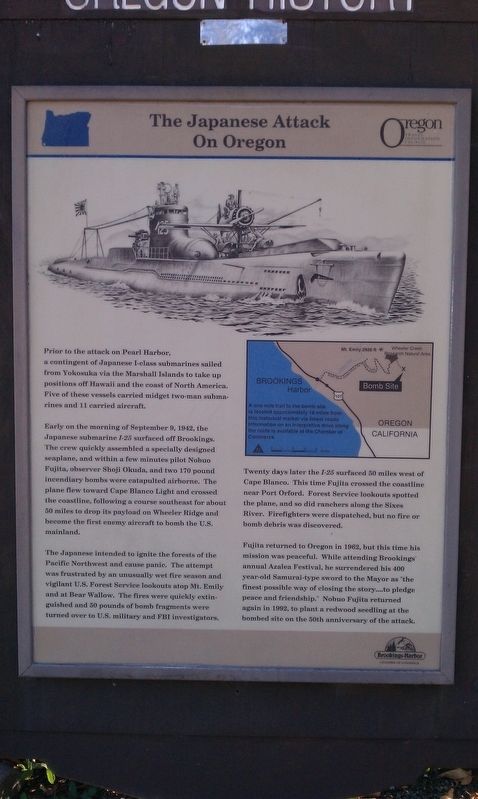
Prior to the attack on Pearl Harbor, a contingent of Japanese I-Class submarines sailed from Yokosuka via the Marshall Islands to take up positions off Hawaii and the coast of North America. Five of these vessels carried midget two-man submarines . . . — — Map (db m112537) HM
On Oregon Coast Hwy (U.S. 101), on the left when traveling north.
Spanish navigators were the first to explore the North American Pacific Coast, beginning fifty years after Columbus discovered the western continents. Sebastian Vizciano saw this cape in 1603 and named it after the patron saint of the day of his . . . — — Map (db m113292) HM
On Jerry Flat Road (Oregon Route 595), on the left when traveling east.
1877 .4 miles up this creek
R.D. Hume started the
first fish hatchery
in Oregon.
1906 Frank Colvin Mgr.
1.6 million fish released.
1926 The state took over the hatchery
1935 The state closed the hatchery
1939 Bob Knox bought . . . — — Map (db m150606) HM
On Ellensburg Avenue (U.S. 101) north of Gauntlett Street, on the right when traveling north.
Gold discovered on the beaches at the mouth of Rogue River in the mid-1800s brought miners here; resulted in the Rogue River Indian Wars of 1855-56.
Prattsville, Ellensburg, officially becoming Gold Beach in 1890.
In the 60’s returns from . . . — — Map (db m113220) HM
On Oregon Coast Hwy (U.S. 101), on the right when traveling north.
Gold Beach Ranger Station constructed 1936–37 placed on the National Register of Historic Places April 8, 1986 The nine original buildings on this site were designed by W.I. Turner and constructed by Civilian Conservation Corps . . . — — Map (db m113206) HM
On Harbor Way (U.S. 101), on the right when traveling south.
In 1876 Mr. R.D. Hume of Astoria, Oregon, decided to move his commercial salmon fishing, processing and shipping business to the mouth of the Rogue River. Mr. Hume anticipated huge profits due to the large run of "King" Salmon which entered the . . . — — Map (db m73202) HM
On Harbor Way west of Oregon Coast Highway (U.S. 101), on the right when traveling west.
Patterson Bridge
(Rogue River Bridge)
Completed January 21, 1932 and dedicated In Memory to the Governor of Oregon Isaac Lee Patterson (1926-died in office 1929)
1932.... The bridge was considered the most advanced concrete . . . — — Map (db m113391) HM
Near Harbor Drive west of Lower Harbor Road, on the right when traveling west.
The Chetco people are the earliest known inhabitants of the Brookings-Harbor area. The Athabaskan-speaking people of Chit-xu and eight other Chetco group villages originally lived along this river and on the adjacent coast between the Winchuck River . . . — — Map (db m176835) HM
Near Harbor Drive west of Lower Harbor Road, on the right when traveling west.
"From the numerous miners and settlers that are pressing into their country they are suffering many grievous wrongs that call for the immediate interference of the Government. Within the last six months four of their villages have . . . — — Map (db m176836) HM
On Oregon Coast Hwy (U.S. 101), on the right when traveling south. Reported missing.
During the early 1850s hundreds of miners and settlers poured into southwest Oregon and onto Indian lands staking claims and establishing farms. The clash of cultural attitudes toward the ownership and use of natural resources led to the Rogue River . . . — — Map (db m113293) HM
On Oregon Coast Highway (U.S. 101) at Jefferson Street, on the right when traveling east on Oregon Coast Highway.
The Tututní people lived along the Southern Oregon coast, including this site, and the lower Rogue River for thousands of years before first contact with explorers, miners, and settlers.
In 1792, George Vancouver was among the first outsiders to . . . — — Map (db m176841) HM
On Oregon Coast Highway (U.S. 101) at Jefferson Street, on the right when traveling east on Oregon Coast Highway.
Battle Rock City Park has been dedicated in memory of the ancient people (Dene Tsut Dah) and the pioneer founders of this townsite. In 1850, the U.S. Congress passed the Oregon Donation Land Act. This act allowed white settlers to file claims on . . . — — Map (db m176821) HM
On Cape Blanco Road west of Oregon Coast Highway (U.S. 101), on the right when traveling west.
Patrick and Jane Hughes' strong support of education and religion helped their children and community flourish.
John Hughes
The third Hughes son, John, studied in the east for the priesthood and was ordained in . . . — — Map (db m113408) HM
Near Cape Blanco Road, 3.9 miles west of U.S. 101, on the right when traveling west.
While you're in the Port Orford area, we invite you to visit three historic sites — Cape Blanco Light Station, Historic Hughes House, and Port Orford Lifeboat Station. All three are on the National Register of Historic Places. Together they tell the . . . — — Map (db m176850) HM
On Cape Blanco Road, 5 miles west of U.S. 101, on the right when traveling west.
While you're in the Port Orford area, we invite you to visit three historic sites — Cape Blanco Light Station, Historic Hughes House, and Port Orford Lifeboat Station. All three are on the National Register of Historic Places. Together they tell the . . . — — Map (db m176952) HM
Near Cape Blanco Road, 3.9 miles west of U.S. 101, on the right when traveling west.
Imagine starting a farm from scratch on isolated, raw land, with no running water, refrigeration or electricity. Everything was hard; everything was physical.
The family cleared great stands of spruce, rooting out the stumps with teams of horses, . . . — — Map (db m176853) HM
Near Cape Blanco Road, 3.9 miles west of U.S. 101, on the right when traveling west.
As American life modernized in the early 1900s, the Hughes family adapted by making improvements to their farm.
When their father, Patrick Hughes, died from a tragic horse accident in 1901, the three bachelor sons took over the farm. The quiet, . . . — — Map (db m176857) HM
Near Cape Blanco Road, 3.9 miles west of U.S. 101, on the right when traveling west.
For thousands of years, the Sixes River has been a source of food, transportation, and fun for all who have lived here.
They called the river and the village at its mouth "Sekwetse," according to Coquille and Siletz Tribal sources. Sekwetse means . . . — — Map (db m176860) HM
On Feb. 10, 1937, winds over 75 M.P.H. caused the 190 foot steam schooner "Cottoneva" to run aground at Battle Rock. It was in port loading lumber. The captain and all 26 seamen were rescued by the Coast Guard crew using a breeches body. The . . . — — Map (db m73203) HM
On Oregon Coast Highway (U.S. 101) 0.1 miles north of Sixes River Road, on the left when traveling north.
In 1852, gold was found in the beach sands at Whiskey Run, about ten miles north of Bandon. Gold was also found on beaches at South Slough, Bandon, Cape Blanco, Port Orford, Ophir, Pistol River and Gold Beach>
Gold was washed onto the beaches by . . . — — Map (db m176822) HM
On Northwest Franklin Avenue near Northwest Sisemore Street, on the right when traveling east.
"Klondike Kate" (Kitty Rockwell) was also known as the "Queen of the Yukon" during the Klondike Gold Rush and came to Bend in 1914. She made a small fortune in the Yukon as the region's leading singer and dancer but fell in love with Alex Pantages, . . . — — Map (db m157837) HM
Pilot Butte was a beacon for travelers.
On a day sometime in the year 1813, and Indian lookout, from one of several tribes summering in this vicinity, might have “hiked the butte” and from here observed an exploration party . . . — — Map (db m63090) HM
On Northwest Greenwood Avenue at Northwest Harriman Street, on the left when traveling east on Northwest Greenwood Avenue.
A.J. Tucker came to Bend in 1916 with $180.00 in his pocket. His first work in Bend was building boats and guiding hunting parties from the eastern United States.
Tucker soon set his sights on building, and went on to create several of Bend's . . . — — Map (db m157707) HM
Near Northwest Brooks Street near Northwest Franklin Avenue.
A.M. Drake and his wife Florence set camp at the bank of the Deschutes River in June 1900 enticed by the 1894 Federal Carey Act, which encouraged private enterprise to reclaim and develop desert land by building irrigation systems and infrastructure . . . — — Map (db m157945) HM
On Northwest Bond Street near Northwest Oregon Avenue, on the right when traveling north.
In 1905, the Aune brothers opened a livery stable and feed store on Bond Street and soon expanded it sot that by 1908, their large barn occupied one-half of the block on the east side of the street. The Aune brothers specialized in providing heavy . . . — — Map (db m157556) HM
On Northwest Newport Avenue near Northwest Brooks Street, on the right when traveling west.
The dam and powerhouse were built in 1910 and 1913 respectfully by the privately-owned Bend Water, Light and Power Company. and were subsequently sold to the Pacific Power and Light Company. The dam, which holds back the waters of the Deschutes . . . — — Map (db m157894) HM
On Northwest Minnesota Avenue near Northwest Lava Road, on the right when traveling east.
Frontier towns had a long way to go before achieving the fire fighting capabilities of more established communities and fires were an ever-present threat; firefighters had their hands full just getting to the scene. In 1918, Tom Carlon took over as . . . — — Map (db m157911) HM
On Northwest Bond Street near Northwest Minnesota Avenue.
Partners Floyd Dement and George Childs started a hardware business in 1912 and relocated to this building in 1918. The two worked together until 1935 when they had a falling out and dissolved their partnership. Neither one ventured too far, . . . — — Map (db m157560) HM
On NW Newport Ave at 35 NW Drake Rd, on the right when traveling east on NW Newport Ave.
Honoring the men and women of Bend who have served, are serving and will serve to defend our freedom during times of peace and war. Remembering the POW, the MIA, and those named below who have made the supreme sacrifice. They will not be forgotten. . . . — — Map (db m113347) WM
On Northwest Wall Street at Northwest Minnesota Avenue, on the right when traveling north on Northwest Wall Street.
The R.N.Bushwalter's Sport Store was the first full-service sporting goods business in Central Oregon. "Buck" -as he was known, offered auto accessories, a large selection of guns, ammunition and fishing tackle, The first pair of skies sold in . . . — — Map (db m157626) HM
On Northwest Wall Street near Northwest Newport Avenue, on the left when traveling north.
The Capitol Theatre was built as the "Carmody Theatre" in 1914 by Dennis Carmody, who placed a "C" on the back of each seat. B.A. "Dutch" Stover bought the theatre in the 192-s and to avoid purchasing new seats, changed the name of the theatre to . . . — — Map (db m157914) HM
Near Northwest Brook Street near Northwest Oregon Avenue.
This plaque is all that is left of the homesite of Clyde McKay, a man who irrevocably shaped the destiny of Bend. McKay persuaded Eastern lumber interests to expand operations in Bend and join him in forming The Bend Company. This company purchased . . . — — Map (db m157705) HM
On Northwest Wall Street at Northwest Vermont Street on Northwest Wall Street.
Built by A.C. Lucas in 1904 at the corner of Wall Street and Newport Avenue, the Colonial Inn began life as the Pilot Butte Inn. It was move north of its original site in 1916 to make room for a new, larger Inn and was re-named the "Colonial Inn." . . . — — Map (db m157890) HM
On Northwest Greenwood Avenue near Northwest Bond Street, on the left when traveling west.
For ladies traveling alone, the Cozy Hotel was the only respectable hotel in town. In those days, The Bend Bulletin printed the guest list of the three "higher class" hotels in town; the Cozy was among them. With its twenty-foot ceilings in . . . — — Map (db m157562) HM
On Northwest Bond Street near Northwest Greenwood Avenue, on the right when traveling north.
The county court was created along with the establishment of Deschutes County in 1916. For the first nineteen years, county offices and the courthouse leased space in the O'Kane Building, then county rented the former Central School from the school . . . — — Map (db m157846) HM
On Northwest Bond Street near Northwest Greenwood Avenue, on the right when traveling north.
William P. Downing arrived in Bend in 1902, traveling from Bemidji, Minnesota. He got the idea of selling lunches to millworkers, and parlayed the operation into a restaurant on Bond Street. Following the American dream of expansion, he set his . . . — — Map (db m157558) HM
Near Northwest Brooks Street near Northwest Oregon Avenue.
Height: 80+ feet
Circumference: Approximately 80 feet
Age: 300+ years
This grove of old-growth Ponderosa Pines shaded the extensive lawn of the 1901 A.M. Drake home in the future sited of Bend. Drake's Pilot Butte Development Co. . . . — — Map (db m157654) HM
On Northwest Wall Street at Northwest Newport Avenue, on the right when traveling north on Northwest Wall Street.
Eddie Williamson was Bend's first major auto dealer. He arrived in Bend with his family as youngster in 1916. When he was still young, his family moved to Eugene, but Eddie stayed behind and learned the automobile business. After owning several . . . — — Map (db m157913) HM
On Northwest Oregon Avenue near Northwest Irving Avenue, on the left when traveling east.
The original First Baptist church, erected on this site in 1904, was the first church building constructed in Bend. It was built on land obtained on May, 7, 1904, form A.M. Drake, Bend's founder, for $1.00 on the condition that no liquor would be . . . — — Map (db m157835) HM
Near Northwest Broadway Street near Northwest Franklin Avenue.
Covered wagons poured into the Willamette Valley for over a quarter of a century before Euro-American settlers arrived here in great numbers. Alexander M. Drake, who arrived at the spot in 1900, was one of the first to realize the high prospects of . . . — — Map (db m157706) HM
On Northwest Brook Street near Northwest Oregon Avenue.
The Goodwillie-Allen-Rademacher House, built in 1904, is one of the oldest Craftsman Bungalow style homes in Oregon, and is the last remaining house from that era on the east side of Mirror Pond. This house was officially listed in the National . . . — — Map (db m157653) HM
On Northwest Wall Street near Northwest Newport Avenue.
On This Site
stood Oregon's
Historic
Pilot Butte Inn
1917 - 1973
This gate was one quaint feature of a Bavarian-style hotel described by author Irvin Cobb as "the finest little hotel in America." It was a popular stopping place . . . — — Map (db m157891) HM
On Northwest Franklin Avenue near Northwest Sisemore Street, on the right when traveling east.
This site marks the home of Kathleen "Klondike Kate" Rockwell, about whom the book "The Life & Legend of Kitty Rockwell, Queen of the Yukon" was written. Much of that legend was made here in Central Oregon, where she took up a homestead in 1914. . . . — — Map (db m157838) HM
Near SW Powerhouse Drive north of SW Columbia Street when traveling west.
To supply the lumber mills with logs, entire mobile towns were created in the woods to house the men and their families who cut down the trees. The towns were movable camps conveyed by railroad cars. From 1916, these temporary towns, or logging . . . — — Map (db m113935) HM
Near Northwest Linster Place near Northwest Harriman Street.
Purportedly the largest outdoor swimming tank in the state in the 1920s was located in Bend on the banks of the Deschutes River, just downstream from Pioneer Park. The 50 x 150 foot steel tank held 330,000 gallons of water. The water came directly . . . — — Map (db m157950) HM
Near National Forest Road NF-100 north of Cottonwood Road.
Geologists say the volcanic activity of this area occurred less than 6000 years ago. Lava which exuded from the south side of this butte flowed to the west and blocked the Deschutes River, deflecting it from its former channel. This formed the . . . — — Map (db m68673) HM
Near Cottonwood Road, 0.7 miles north of Exit 151 (U.S. 97).
(Marker #1) Welcome LAVA RIVER CAVE is one of Oregon's longest (5466 feet) uncollapsed lava tubes. About 100,000 years ago, this conduit carried 2000° F. (1100° C.) lava from an upslope vent to lower areas on the flanks of the Newberry . . . — — Map (db m92909)
On Northwest Wall Street near Northwest Minnesota Avenue, on the left when traveling north.
The original facade on the Liberty Theater was a dazzling white stucco adorned with musical instruments in relief. The theater had a combined seating capacity of five hundred on the ground floor and balcony. This is the oldest movie theatre left . . . — — Map (db m157612) HM
Near SW Columbia Street east of SW Shevlin Hixon Drive when traveling north.
The bustling marketplace you see today, filled with shops, theaters, restaurants, entertainment and recreation was once the site of the largest pine sawmills in the country.
Back in the 1920s, they were busy, noisy and dusty mills, each . . . — — Map (db m113931) HM
Near SW Powerhouse Drive north of SW Columbia Street when traveling west.
Trees were felled in the woods and hauled to the Deschutes River where they floated downstream to the mills.
The final steps of this log-to-lumber journey occurred as the wet lumber, known as green wood, exited the mill on the green chain.
As . . . — — Map (db m113933) HM
On Northwest Wall Street near Northwest Oregon Avenue, on the left when traveling north.
Nicholas Paul Smith's hardware store was a welcome sight in Bend because up until then supplies has to be brought in from Shaniko by stagecoach. Quick to spot a trend, Smith was the first to sell gasoline to the increasing number of automobile . . . — — Map (db m157652) HM
On Northwest Wall Street near Northwest Oregon Avenue, on the left when traveling north.
The facade styling of this building was ambitious for the time and it helped to popularize the unique brick used as the building material. The bricks were made of clay for the Bend Brickyard west of town and fire white sand from the Ice Caves south . . . — — Map (db m157651) HM
On Northeast 1st Street at Northeast Greenwood Avenue, on the right when traveling north on Northeast 1st Street.
In its time, O'Donnell Field was one of the largest outdoor arenas in the state and was used for baseball and football games, track and field meets, rodeos, and by traveling carnivals and the Clyde Beatty Circus. It was built in 1916 for $400 and . . . — — Map (db m157844) HM
On Northwest Bond Street at Northwest Oregon Avenue, on the left when traveling north on Northwest Bond Street.
Hugh O'Kane, an illegal immigrant from Ireland, built the magnificent O'Kane Building. Regarded as the finest example of the Chicago Mercantile Style in Bend, it is still the largest commercial structure in downtown Bend.
O'Kane's role, as a . . . — — Map (db m157557) HM
On Northwest Wall Street near Northwest Franklin Avenue, on the left when traveling south.
The Bend Bulletin occupied several buildings over the years, but this building is perhaps the most historically significant since The Bend Bulletin operated from this site from 1940 to 1966. On May 15, 1963, the newspaper changed it's . . . — — Map (db m157610) HM
On NW Wall Street south of NW Riverside Boulevard, on the right when traveling south.
Construction of the Old Post Office established the presence of the federal government in this area.
It was a project of the Public Buildings Program, a federal agency created by President Herbert Hoover.
As one of the first buildings with . . . — — Map (db m113264) HM
This complex ecosystem nurtures a variety of plants and animals.
Vast, sage-covered plains begin at the eastern foot of the Pilot Butte and stretch dramatically to the east and south. This is Oregon’s fabled “High Desert”. The . . . — — Map (db m63094) HM
On Northwest Harriman Street near NorthwestThough, on the left when traveling south.
Although Pete Pierson was the original blacksmith, he soon sold his business to Joe Egg, who ran the business for fifty years. As late as 1973, Egg was well-known in Bend and Redmond as an ace blacksmith. In that year, Egg told The Bulletin . . . — — Map (db m157708) HM
Near Northwest Wall Street near Northwest Newport Avenue, on the left when traveling north.
This is the site of the Pilot Butte Inn, which was known far and wide as an excellent small hotel. Built by Philips Brooks of the Brooks Mill Family, the Inn was the focal point for community activities for many years. A massive lava rock fireplace, . . . — — Map (db m157947) HM
On Northwest Brooks Street at Northwest Oregon Avenue, on the left when traveling north on Northwest Brooks Street.
In 1936, partners Maren Gribskov and Eleanor Bechen were looking to expand their restaurant operation and build their own facility in the English Tavern style. They found the perfect location overlooking the Deschutes River. The named for the large . . . — — Map (db m157944) HM
Near Northwest Brook Street near Northwest Oregon Avenue.
Clyde McKay first came to Bend in 1900 and returned every year thereafter until he moved his family to Bend in 1911. That same year he formed the Bend Company, which purchased the Drake holdings, including the original townsite, a sawmill and power . . . — — Map (db m157655) HM
On Northwest Wall Street at Northwest Oregon Avenue, on the left when traveling north on Northwest Wall Street.
Although named for A.M. Pringle, it was Maurice Cashman who purchased the half-finished building and who is most associated with it. Cashman turned the building into a premier retail space that housed several stores. Al Eriksen bought the building . . . — — Map (db m157942) HM
Near Forest Road 9702, 4 miles west of The Dalles-California Highway (U.S. 97).
This cableway was installed in 1905 by the United States Geological Survey to measure the river's flow.
Today instruments sense and record the elevation of the water surface.
This information is relayed by satellite into computers of water . . . — — Map (db m114253) HM
On Northwest Wall Street near Northwest Minnesota Avenue, on the right when traveling north.
Evan A. Sather opened this two-story mercantile business and called it the Pine Tree Store because of a pine tree that grew through the front sidewalk. The upstairs was known a Sather Hall and became a popular gathering place for civic and social . . . — — Map (db m157625) HM
Near Cottonwood Road, 0.7 miles north of Exit 151 (U.S. 97).
You may already know about pipelines. Oil, water and gas, chemicals, medicine and food flow to us through pipes and tubes. Pipelines are a naturally efficient way to move fluid from one place to another. Nature constructs marvelous . . . — — Map (db m92910)
Near SW Powerhouse Drive north of SW Columbia Street when traveling west.
Huge trees were felled in the woods and the logs were transported by railroad to town. They were then dropped into the Deschutes River to await their turn in the mill. The river was a perfect storage place for the logs. The natural flow of the . . . — — Map (db m113936) HM
In the beginning...there were old growth trees.
The small community, first called Farewell Bend from the nearby big bend in the Deschutes River, could have been called “Pilot Butte” if the 1901 recommendation of Postmaster William . . . — — Map (db m63089) HM
Near SW Powerhouse Drive north of SW Columbia Street when traveling west.
From the woods to the Deschutes River, the log was hoisted by the bull chain into the mill from the river to the log deck.
It was then directed to the band saw in one of the three head rigs, where the process began.
It was the head sawyer's . . . — — Map (db m113919) HM
Near SW Powerhouse Drive north of SW Columbia Street when traveling west.
The mills may be gone, but their legacy is apparent all around us. The lumber companies spurred Bend's growth and they helped a lot of folks raise their families in this area. Today we see evidence of Mill B every time we look at the three iconic . . . — — Map (db m113932) HM
On Northwest Wall Street near Northwest Minnesota Avenue, on the left when traveling north.
The original Tower Theatre was built in 1940 in about three months by two shifts of workers employed by local contractor, Fred Van Matre. The building was dominated by the large "Tower" sign that rose 40 feet above the building to a height of 78 . . . — — Map (db m157624) HM
On Northwest Greenwood Avenue at Northwest Harriman Street, on the right when traveling east on Northwest Greenwood Avenue.
The railroad brought the outside world to Bend's doorstep, and the builders of what was then the Taggert Hotel knew exactly how to capitalize on it. Located just one block from the depot, the hotel was a modern, fireproof structure with electricity . . . — — Map (db m157946) HM
Near Paulina Lake Road (NF-21), 0.7 miles east of National Forest Service Road 567 (NF-567).
Where people lived near obsidian, their lives and cultures were transformed. They used and celebrated the glassy gift of volcanoes to manufacture tools, weapons, jewelry, sculptures, and ceremonial objects. To ancient Central American people, the . . . — — Map (db m72437) HM
Near Paulina Lake Road (NF-21), 0.7 miles east of National Forest Service Road 567 (NF-567).
The furnaces of the earth brought spectacular change to this land 1300 years ago. A new, rough, glassy environment offered a harsh home for the heartiest plants and animals. Past cultures prized the shiny black rock for their survival. Today, the . . . — — Map (db m72434)
Near State Recreation Road, 5 miles west of The Dalles-California Highway (U.S. 97).
This majestic pine is the biggest of its species ever recorded. It was a giant before the Oregon Territory was established, enduring centuries of fire, insects, disease, and human impact.
Recently half of its crown was lost to weather, . . . — — Map (db m114266) HM
Near Paulina Lake Road (NF-21), 0.7 miles east of National Forest Service Road 567 (NF-567).
The entire surface of this remarkable flow is glass, a liquid that cooled without crystallizing. The striking differences you see from rock to rock are due to the number and size of bubbles.
Why is everything glass?
Whether natural or . . . — — Map (db m72435)
Near Paulina Lake Road (NF-21), 0.7 miles east of National Forest Service Road 567 (NF-567).
First came a violent eruption of pumice and ash. Then glassy lava oozed from the ground.
(Graphic Index)
1 Magma Chamber
From deep hot regions, liquid rock called magma accumulated in a chamber 2 to 4 miles (3 to 6 km) below the . . . — — Map (db m72436)
On Central Oregon Highway (U.S. 20) near Spencer Wells Road (County Route 23), on the left when traveling east.
Ages ago a river flowed across the high desert country in the rock canyon several hundred yards beyond this marker. The prehistoric river drained a large Ice Age lake that formed from the blocking of normal drainage in the area by lava flows. The . . . — — Map (db m157842) HM
On East Cascade Avenue (U.S. 20) at North Fir Street, on the right when traveling west on East Cascade Avenue.
The hotel was built in 1912 by local businessman and Spanish American War veteran John Dennis. Hot and cold water was available to each of the original 19 guest rooms, and every room was supplied with heat from a hot air furnace located in the . . . — — Map (db m113631) HM
On East Cascade Avenue near South Spruce Street, on the left when traveling west.
Built in 1925 by the Leithausers, an early Sisters family. The structure served as a general store until 1950, when a new store was built two lots to the West. Over the years, the building has been used as a barber shop, variety store, yarn mill and . . . — — Map (db m158083) HM
Near McKenzie Highway (Oregon Route 126) 1.6 miles south of U.S. 20, on the right when traveling south.
You are standing on the shore of a lake that may seem old but in geologic terms was formed yesterday. Fish Lake continues to change, seasonally and through the decades.
Around three thousand years ago an eruption of Nash Crater formed Fish Lake . . . — — Map (db m70950)
On East Cascade Avenue (U.S. 20) at South Elm Street, on the left when traveling west on East Cascade Avenue.
The original structure on this site was owned by the Aitken family and called the Sisters Drug Store. It also housed the town post office. The upstairs was used by the Forest Service to store records. It was destroyed by the fire of 1923. Shortly . . . — — Map (db m158082) HM
Near McKenzie Highway (Oregon Route 126) 1.6 miles south of U.S. 20, on the right when traveling south.
Welcome to historic Fish Lake.
Now a quiet and peaceful place, it was once filled with the hustle and bustle of people working and traveling across the Cascades.
Nearby is the Fish Lake Remount Depot which has been in continuous use as a . . . — — Map (db m62025) HM
On Great Hall Loop, on the right when traveling east.
In November 1942 the cattle contentedly grazing on what is now Sunriver’s great meadow found themselves suddenly replaced by dozens of energetic construction workers. Laboring through what was called “the worst winter since 1919,” they completed a . . . — — Map (db m231867) HM WM
Near Blue Star Memorial/Dalles to California Highway (U.S. 97 at milepost 113), 1.2 miles north of Wimp Way, on the left when traveling north.
Peter Skene Ogden was born at Quebec in 1794. He explored Central Oregon for the Hudson's Bay Company in 1825 and in December of that year discovered Crooked River not far from this spot. He died at Oregon City in 1854.
Land for this park was . . . — — Map (db m80487) HM
On Southwest 5th Street at South East Canyon Street, on the right when traveling east on Southwest 5th Street.
(Seven panels dealing with topics related to the Applegate Trail are found at this kiosk.)
Applegate Trail
Southern Route to Oregon
In 1846, Jesse Applegate and fourteen others from near Dallas, Oregon, established . . . — — Map (db m112862) HM
This portion of the southwest Oregon is homeland to the Cow Creek Band of Umpqua Indians. They thrived here for thousands of years before contact with Euro-Americans. Living in plank-house villages, they followed a seasonal round of resource use. . . . — — Map (db m112859) HM
On Elkton-Sutherlin Highway (Oregon Route 138) south of Mehl Creek Road, on the right when traveling south.
On the west bank and upstream is the site of Fort Umpqua.
Established in 1836 by the Hudson’s Bay Company, the fort was a twelve foot high and ninety foot square stockade with bastions at diagonal corners.
The fort served as a dwelling for . . . — — Map (db m113337) HM
On Oregon Coast Highway (U.S. 101) at Jewett Lane, on the right when traveling south on Oregon Coast Highway.
On October 1, 1850, the schooner "Bostonian” owned by a Boston merchant named Gardiner was sent to the Pacific coast in the interest of trade. The ship wrecked on the Umpqua River bar. Most of her cargo was salvaged and brought to this site, known . . . — — Map (db m176983) HM
After construction of a railroad line South from Roseburg in 1881-1883, Solomon Abraham, the local right of way agent, platted the community and named it Julia after his wife. After a dispute with Abraham, A.F. Morris, the Chief Engineer for the . . . — — Map (db m134058) HM
Near Volunteer Way near SW 2nd Avenue, on the right when traveling east.
Used in the grist mill built in 1853-54 by Lazarus Wright. The mill was located next to the planked bridge crossing in the 'village' of Myrtle Creek near the current location of the Dairy Queen. The mill was managed by John Hall, the founder of . . . — — Map (db m114456) HM
On NE 1st Street at SE Maple Street, on the left when traveling north on NE 1st Street.
In 1846, Jesse Applegate and fourteen others from near Dallas, Oregon, established a trail south from the Willamette Valley and east to Fort Hall. This route offered emigrants an alternative to the perilous “last leg” of the Oregon Trail . . . — — Map (db m116842) HM
On 1st Street at Locust Street, on the left when traveling north on 1st Street.
Established in 1851 by Dr. Dorsey S. Baker. The town moved to the present site in 1872 when the O&C Railroad reached this point. Alonzo F. Brown founded the new town. Fires destroyed the wooden buildings. The existing brick buildings were built in . . . — — Map (db m99321) HM
On Interstate 5, on the right when traveling south.
The story of the Cow Creek Band of Umpqua Tribe of Indians is a tale of perseverance and strong recovery in the face of great loss. Epidemics and hostilities with miners let to large population declines. The tribe entered into a treaty with the . . . — — Map (db m99222) HM
On Old Highway 99 North north of North Old Town Road, on the right when traveling north.
Dedicated to the memory of
Rev. J.A. Cornwall and Family
They built the
First Immigrant Cabin
in Douglas County near
this site hence the name
Cabin Creek
The family wintered here in
1846 1847
Were saved from extreme want
by . . . — — Map (db m99269) HM
On SE 2nd Street at SE Maple Street on SE 2nd Street.
Taken from a grist mill built in old town of Oakland by Dr. Dorsey S. Baker in 1851.
It turned the grinding stone that ground the grain to meal and flour. Shipped by boat around Cape Horn in the older days. — — Map (db m116841) HM
On Umpqua Highway (Oregon Route 38) 4 miles west of Loon Lake Road, on the right when traveling west.
On August 8th, 1850, the schooner Samuel Roberts grounded on this bar during her maiden voyage to Scottsburg as part of the Klamath exploring expedition.
She was the first recorded American Vessel to navigate the Umpqua River.
While waiting . . . — — Map (db m113339) HM
On Water Avenue at North 3rd Street, on the left when traveling east on Water Avenue.
A Big Piece of Reedsport History
Here, restored by citizens of Reedsport, is one of the largest steam donkeys to work the Oregon woods, the Smith and Watson 12 X 13 compound geared universal yarder. It was placed in service in 1915 . . . — — Map (db m113331) HM
On Oregon Coast Highway (U.S. 101) 0.1 miles south of Lower Smith River Road, on the right when traveling south.
Jedediah Smith's explorations in the American West began when he was 21 and lasted until his death at age 32. He crisscrossed the region in search of beaver pelts and new travel routes. His travel journals became a foundation for the first accurate . . . — — Map (db m176970) HM
On Oregon Coast Highway (U.S. 101) 0.1 miles south of Lower Smith River Road, on the right when traveling south. Reported missing.
Jedediah Smith, making the first recorded overland trip from California,
followed the Oregon coast northward
and on July 13, 1828 camped with seventeen trappers on the north bank of
Smith River channel five-eights
of a
mile northeast of this . . . — — Map (db m237385) HM
On Lighthouse Road west of Oregon Coast Highway (U.S. 101), on the right when traveling north.
This former U.S. Coast Guard facility built in 1939, was restored by the Douglas County Park Department and dedicated as a public recreation facility on June 19, 1980.
Douglas County Board of Commissioners
Bill Vian, Chairman
. . . — — Map (db m113507) HM
1191 entries matched your criteria. Entries 301 through 400 are listed above. ⊲ Previous 100 — Next 100 ⊳