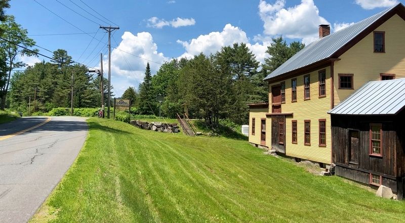
This water-powered mill on the Stevens River was built in 1872 by Alexander Jack. It originally housed a patented woolen print and dye works. In 1893, James Judkins retooled it as a wagon and woodworking shop. Judkins’ Shop was later run by sons . . . — — Map (db m136055) HM
Henry Stevens
Born in Barnet on December 13, 1791, and educated at Peacham Academy, Henry Stevens was at various times a farmer, innkeeper, mill owner, legislator, postmaster, temperance leader, stage line proprietor, and operator of the . . . — — Map (db m77691) HM
On Vermont Route 5, on the left when traveling south.
Local builder Fred “Silo” Quimby built this round barn, considered a great curiosity, in 1900 for farmer James R. Moore. Popularized by Midwest agricultural colleges in the 1890s, round barns were considered more economical to build and . . . — — Map (db m136060) HM
On Interstate 91 at milepost 121.8, on the right when traveling north.
The Connecticut River, starting at the International Boundary, flows 380 miles to the Atlantic Ocean. In its course the river falls 1640 feet. In 1928, the New England Power Association started a two-year project to build one of the largest . . . — — Map (db m74467) HM
In honor of the brave men of Danville who victoriously defended the Union during the War of the Rebellion
1861 - 1865
Commissioned Officers
Colonel Addison W. Preston •
Captain James M. Ayer •
Captain Charles D. Brainerd • . . . — — Map (db m140332) WM
On Greenbanks Hollow Road at Brook Road, on the right when traveling south on Greenbanks Hollow Road.
On this site, in 1849, Benjamin Greenbank converted an existing small mill into a 5-story woolen factory. As many as 45 people worked here to produce up to 700 yards of cloth a day. Greenbank's Hollow, as it became known, included a company store, . . . — — Map (db m61392) HM
On Theodore Roosevelt Hwy (U.S. 2) at Peacham Road, on the right when traveling east on Theodore Roosevelt Hwy.
Born crippled and poor in Danville in 1792, Stevens was schooled by his mother, Sally Morrill Stevens, and at nearby Caledonia County Grammar School, graduating from Dartmouth College in 1814. He became a brilliant lawyer, committed to racial . . . — — Map (db m20664) HM
On Darling Hill Road at East Darling Hill Road, on the right when traveling south on Darling Hill Road.
This farm was established in 1883 by Elmer A. Darling (1848-1931), a native of East Burke who became part owner/manager of the world famous Fifth Avenue Hotel in New York City. After the hotel closed in 1908, Mr. Darling retired to the life of a . . . — — Map (db m75981) HM
On Scott Highway (U.S. 302) at Mill Street, on the right when traveling west on Scott Highway.
In Memory
Of
The Brave Soldiers
Of The
Town Of Groton
Who Served During
The Civil War
1861 – 1865
Left Face:
Groton's Roll Of Honor
In The Civil War
Vermont Infantry Co. Regt.
Sergeant . . . — — Map (db m157719) WM
On Scott Highway (U.S. 302) 1.2 miles west of Seyon Pond Road (County Route 24), on the left when traveling west.
In memory of William Scott the sleeping sentinel pardoned by Abraham Lincoln Sept. 9th, 1861. Born on this farm Apr. 9th, 1839. Enl. in Co. K, 3rd Vt. Vol. July 10th, 1861. Died of wounds at Lees Mills Apr. 16th, 1862. — — Map (db m155867) HM WM
Dr. Merle Frampton established Camp Wapanacki here in 1938. It was the first camp in the country dedicated to children with blindness and visual impairments. Dr. Frampton and his wife, Iris, managed Wapanacki until 1942, when operations were . . . — — Map (db m136061) HM
Founded in 1780, the Town of Lyndon was home to 59 residents at the time of the 1790 census. In June 1791 the inhabitants and freeholders were invited to the first town meeting, held here at the home of Daniel Reniff.
On July 4, Elder Philemon . . . — — Map (db m177610) HM
Near Cemetery Circle west of Center Street, on the right when traveling west.
The children of Lyndon Center attended school in this wooden building for 43 years. It then served as a cemetery storage garage until its restoration by the Lyndon Historical Society during 2002-2004. Now it is home to an exhibit depicting life in a . . . — — Map (db m136692) HM
On Institute Circle just north of College Road, on the left when traveling north.
Born in Lyndon, Vermont, in a log house, February 21, 1821. Daughter of Samuel Rowell, a farmer and Mary Atwood. Being one of twelve children and brought up under hardships and privations, Elizabeth had little schooling. At age nine she went out to . . . — — Map (db m152259) HM
Near Center Street at Cemetery Circle, on the left when traveling north.
Built by the Town of Lyndon in the summer of 1809 as a meeting house for the religious services of four congregations – Baptist, Congregational, Methodist, and Universalist – and for town meetings. The “Town House” was . . . — — Map (db m136690) HM
On Center Street (Vermont Route 122) at College Road, on the right when traveling north on Center Street.
Dedicated to the memory of Theodore Newton Vail (1848–1920), president of the American Telephone and Telegraph Company, a most generous benefactor of Lyndon Institute and Vail Agricultural School – one who had faith in the young people . . . — — Map (db m87926) HM
On College Road 1 mile Center Street ( Route 122), on the left when traveling south.
bought a farmhouse on this site in 1883. Continually enlarged by Vail, it became his permanent residence and office. Conferences held here culminated in the creation of the American Telephone and Telegraph Company with Vail its president, who . . . — — Map (db m75108) HM
On Bridge Street at U.S. 5, in the median on Bridge Street.
Dedicated to all Veterans
of the armed forces of the
United States of America
WW II
F. C. Converse
That others may live
( reverse side )
WW II
★R. F. Kipp · P. E. Kipp · R. W. Irwin · E. G. Hall · I. A. Foran · . . . — — Map (db m157294) HM
On Bayley-Hazen Road 0.1 miles south of Church Street, on the right when traveling south.
Caledonia County was set out from Orange County in 1792. Peacham chose to provide a County grammar school rather than a courthouse. The Caledonia County Grammar School (Peacham Academy) was chartered in 1795, the third County grammar school in . . . — — Map (db m77694) HM
On Peacham Road at Stonehouse Road, on the right when traveling south on Peacham Road.
In the style of a Scottish stone croft (farmhouse), this house was erected by James Whitehill, a prosperous farmer and one of a large number of immigrants from Inchinnan Parish, Scotland, who settled Ryegate under the sponsorship of the Scotch . . . — — Map (db m77692) HM
On Vermont Route 18 just east of Slate Ledge Road.
Opened on July 18, 1959 as Vermont’s first organized auto racing track under the guidance of the Northeastern Racing Association, the State’s first motor sports sanctioning body. By instituting formal point and purse structures and focusing on . . . — — Map (db m65865) HM
On Main Street (U.S. 2) south of Eastern Avenue (U.S. 2), on the right when traveling north.
On June 28, 1790, Jonathan Arnold donated the land now occupied by the courthouse and park to the "South Parish" of the Village of St. Johnsbury for use as a "Buryal Ground."
By 1855 the burial ground had fallen into disrepair.
Families . . . — — Map (db m116650) HM
On Main Street near Eastern Avenue, on the right when traveling south.
Line of Duty Death
Eugene “Geno” McDonough
December 6, 1943 – September 5, 1998
19 Years of Service
On September 5th, 1998 Firefighter Eugene McDonough responded on Engine Company 3 to a mutual aid call for a multiple alarm warehouse fire at . . . — — Map (db m180782) HM
On Portland Street (U.S. 2) at Spaulding Road, on the right when traveling east on Portland Street. Reported permanently removed.
After experimenting with new types of farm equipment, plows, and stoves, Thaddeus Fairbanks invented the platform scale here in 1830. With his brothers Erastus and Joseph, he founded the company which still bears their name. Many St. Johnsbury . . . — — Map (db m74468) HM
On Western Avenue (U.S. 2) at Mount Vernon Street, on the right when traveling east on Western Avenue.
After experimenting with new types of farm equipment, plows and stoves, Thaddeus Fairbanks invented the platform scale here in 1830. With his brothers Erastus and Joseph, he founded the company which still bears their name. Many St. Johnsbury . . . — — Map (db m77603) HM
On Railroad Street north of Eastern Avenue, on the left when traveling north.
On this site in 1852 the former Cottage Hotel opened for business owned by a Mr. Flint. Later, being part of the Calderwood Family holdings it was sold to Dominico and Maria Costa in 1920. —— By 1935 William T. Costa, Sr. and Joseph Caplan had . . . — — Map (db m180717) HM
On Main Street (U.S. 2) near Eastern Avenue, on the right when traveling north.
Parrot Gun No. 126
Presented To
Chamberlin Post No. 1 G.A.R.
August 1899
By Sec. of Navy on request of
Hon. W.W. Grout.
This gun was in service during
Civil War on U.S.S. Kanawha — — Map (db m180787) WM
On Main Street (U.S. 2) at Eastern Avenue, on the right when traveling north on Main Street.
Parrot Gun No. 126
Presented To
Chamberlin Post No. 1 G.A.R.
August 1899
By Sec. of Navy on request of
Hon. W.W. Grout.
This gun was in service during
Civil War on U.S.S. Magnolia — — Map (db m180785) WM
On Main Street (U.S. 2) at Eastern Avenue, on the right when traveling north on Main Street.
In Honor of
The St. Johnsbury Volunteers
Who Sacrificed Their Lives
In Defence of The Union.
Fredricksburgh. · Gettysburg. · Winchester. · Spotsylvania. · Wilderness. · Port Hudson. · Williamsburg. · Cold Harbor. · Petersburg. · Lees Mills. . . . — — Map (db m180784) WM
On Main Street (U.S. 2) at Eastern Avenue, on the right when traveling north on Main Street.
To the Honor and Glory
of the
Men and Women
of St. Johnsbury
Who Served Their Country in the
1914 World War 1919
and in Memory of
These Noble Dead
Audette Albert A · Bartlett Lowell Arthur · Batchelder Raymond · Birch Arthur B · . . . — — Map (db m180789) HM
On Main Street (U.S. 2) near Eastern Avenue, on the right when traveling north.
This Memorial Erected In
Grateful Memory of Those
Who Died to Preserve Our
Way of Life in World War II
Graydon L. Adams · Glenn C. Badger · Stanley R. Bailey · Kenneth R. Bailey · William W. Balch · Arnold L. Bartlett · Donald R. Bean · . . . — — Map (db m180791) WM
On Main Street (U.S. 2) at Eastern Avenue (U.S. 2), on the left when traveling north on Main Street.
(National Register of Historic Places Plaque)
St. Johnsbury Athenaeum
Has been designated a
National Historic Landmark
This building possesses National Significance
in commemorating the history of the
. . . — — Map (db m116649) HM
On Western Avenue (U.S. 2) 0.3 miles west of Main Street, on the left when traveling west.
Vermont's first and for many years only four year vocational school opened on Western Avenue on September 3, 1918. Needing skilled workers during World War I, Fairbanks, Morse & Co. started an all-day co-operative school where young men could learn . . . — — Map (db m77584) HM
On Vermont Route 122 at Sutton Road, on the right when traveling north on Vermont Route 122.
When Eleazer Wheelock founded Dartmouth in 1769, he sought land grants to support the new college. In 1785 the Vermont legislature chartered and named a town of 23,000 acres for Wheelock. In the early 1800's substantial support for financially . . . — — Map (db m87807) HM
On Vermont Route 109 4.4 miles west of Route 118, on the left when traveling west.
Born in Virginia in 1850, Henderson was employed as a servant by Henry Carpenter, adjutant in the Eighth Vermont Regiment in the Civil War. In 1865 he accompanied Carpenter to his home in Belvidere and began "to learn his letters." After study with . . . — — Map (db m74259) HM
On South Main Street (Vermont Route 15) at Lower Pleasant Valley Road, in the median on South Main Street.
Over ten percent of Vermont's population of 315,000 served in the War of the Rebellion from 1861 to 1865. To honor the 33,000 Union troops, the General Assembly designated VT Route 15 as the Grand Army of the Republic Highway in 1937. Only 18 . . . — — Map (db m305684) HM
On Cambridge Junction Road 0.1 miles north of Grand Army of the Republic Highway (State Route 15), on the left when traveling north.
This bridge was built in 1887 by George W. Holmes in order to access an important railroad junction and the surrounding village of Cambridge Junction. The Burr Arch structure has a clear span of 135 feet, making it one of the longest spans of its . . . — — Map (db m94319) HM
On Cambridge Junction Road, on the right when traveling north.
The 1900's Railway Heyday
The town continued to grow. By 1905 there were over a dozen dwellings new where you stand today. Many still exist, including the old school house, which has been converted into a home.
Roscoe Fuller ran the . . . — — Map (db m207875) HM
On Cambridge Junction Road, on the right when traveling north.
The area where you're standing now looked very different a few hundred years ago. This part of the rail trail was once a bustling train stop with a nearby train station and many more buildings and services that supported the railway. See how . . . — — Map (db m207876) HM
On Church Street (Vermont Route 108) at Main Street, on the right when traveling east on Church Street.
In grateful tribute to the men and women of the town of Cambridge who served in the armed forces of our country to preserve freedom.
Cambridge remembers the men who served in the World War 1917 - 1919
Killed in Action
Nelson R . . . — — Map (db m303765) WM
On Lower Pleasant Valley Road, on the right when traveling east.
The town of Cambridge furnished three hundred and two soldiers. Post No. 10 had during its existence two hundred members.
In memory of Post No. 10, Dept. of VT. — — Map (db m207877) WM
On Vermont Route 15, on the right when traveling east.
This bridge, spanning the Lamoille River on the St. Johnsbury & Lamoille County R. R., is the last railroad covered bridge still in regular use in Vermont and one of the very few left in the U.S. Built in 1908, it is the only remaining with . . . — — Map (db m36934) HM
On Lower Main Street West (Vermont Route 15) 0.6 miles west of Route 100-C, on the right when traveling west.
Julian Scott, Vermont’s most renowned Civil War artist, was born in this Johnson house in 1846. At the start of the Civil War, when only 15, he enlisted as a fifer in the Third Vermont Regiment. Scott was awarded a Medal of Honor -- for rescuing . . . — — Map (db m77551) HM
On Lower Main Street W (Vermont Route 15) at Gould Hill, on the right when traveling east on Lower Main Street W.
Honor Roll
Erected by the Town of Johnson
In Grateful Remembrance of Her Citizens
Who Protected Their Country's Flag
During the Civil War. 1861 — 1865
James H. Adams • Levi B. Adams • Sumner A . Andrews • Frank B. Atwell • Marshall . . . — — Map (db m140633) WM
On Lower Main Street W (Vermont Route 15) at Gould Hill, on the right when traveling east on Lower Main Street W.
Honor Roll
Erected by the Town of Johnson
In Grateful Appreciation of the Services
Rendered by Her Citizens to Their Country
During The World War. 1917-1919
Wallace A. Atwell • ★Howard L. Bailey • Delbert T. Dubray • C. Gordon. . . . — — Map (db m140636) WM
On Portland Street north of Upper Main Street ( Route 12), on the right when traveling north.
from a series of three
Gordon Auchincloss
Stainless steel
Spiral Canopy, one in a series of arboreal-inspired sculptures designed to accentuate important Morrisville institutions, is composed of repeating tiers of stainless steel . . . — — Map (db m261402)
On Portland Street (Old Vermont Route 100) at Bridge Street (Old Route 100), on the right when traveling south on Portland Street.
The Bijou Theatre has operated almost continuously on this site for more than 100 years. The original Bijou, constructed in 1910, was one of the earliest theaters in Vermont to show “talkies”. It was razed in 1937 and this building was . . . — — Map (db m261792) HM
On Lower Main Street (Vermont Route 12) west of Congress Street, on the left when traveling west.
Dewey K. Hickok (1824-1890) of Morrisville was an inventor and a dealer of patent rights. On July 19, 1887, he received a patent for his new invention, a washing machine. Mechanically creative, Hickok also patented a number of other inventions, . . . — — Map (db m261365) HM
On Portland Street (Old Vermont Route 100) north of Brigham Street, on the right when traveling north.
The Elmore Block is a well-preserved, two-story clap-board commercial block with a rectangular false front and Italianate-style bracketed cornice. It also displays an unusual and locally distinctive architectural trait, decorative “ears” where . . . — — Map (db m261774) HM
On Lower Main Street, on the right when traveling east.
The three buildings of the Ferris Block were built circa 1900, each a three-story flat-roofed commercial building. The Ferris building on the far right of the photo was rebuilt in 1949. The upper floors of each building were rental apartments. . . . — — Map (db m261356) HM
On Portland Street at Upper Main Street ( Route 12), on the right when traveling north on Portland Street.
The Fleetwood/Peck Block is a commercial block built in the Greek Revival/Italianate style. Originally constructed as a three-story building, it was known as the Powers and Gleed Block, and later the Fleetwood Block. The Masonic Temple was on . . . — — Map (db m261399) HM
On Upper Main Street (Vermont Route 12) at Pleasant Street, on the right when traveling west on Upper Main Street.
Dr. Horace H. Powers (1807-67) was one of Morristown's original doctors. During the Civil War, he traveled to Virginia to treat wounded Union soldiers. His son H. Henry Powers (1835-1913) became an attorney, served in both the Vermont House and . . . — — Map (db m261397) HM
On Upper Main Street east of Congress Street, on the right when traveling east.
The first building on this site was a church built in 1840. After it was consumed by fire in 1852, a second church was erected in 1865, and it remains largely unchanged to this date. In 1965, with waning church membership, the property was . . . — — Map (db m261370) HM
On Park Street at Richmond Street, on the right when traveling west on Park Street.
Morristown Centennial Library
1912
In 1910, the Town Of Morristown purchased this site, known as the Kelsey property, with the intention of building a library. The building received funding from industrialist Andrew Carnegie on March 18, . . . — — Map (db m261380) HM
On Portland Street at Railroad Street, on the right when traveling north on Portland Street.
Built c. 1872 by the St. Johnsbury and Lamoille County Railroad, a division of the Portland & Ogdensburg Railroad, this depot served as an important stop linking Portland, Maine and the Great Lakes for nearly a century. The original portion of the . . . — — Map (db m97752) HM
On Lower Main Street (Vermont Route 12) east of Portland Street, on the right when traveling west.
The Munson Block is a three-story, flat-roofed, commercial building constructed in 1904 for Harlan P. Munson to house his general store, which also sold feed and hardware in addition to dry goods. Besides the Munson General Store, over the . . . — — Map (db m261754) HM
On Lower Main Street at Brigham Street, on the right when traveling east on Lower Main Street.
In 1816, Jedediah Safford deeded three-quarters of an acre of land on Main Street to David P. Noyes, who built the Village's first general store in 1835. Noyes continued to own and operate the store until 1866, when he sold it to George J. . . . — — Map (db m261759) HM
On Lower Main Street (Vermont Route 100) at A Street, on the right when traveling south on Lower Main Street.
This exceptional brick federal home was built for Jedediah Safford, son of Morrisville's first resident, John Safford. In 1947, the Village of Morrisville, with funding from the Alexander H. Copley Trust, bought the house for use as a community . . . — — Map (db m155274) HM
On Upper Main Street (Vermont Route 12) west of Pleasant Street, on the right when traveling west.
Puffer United Methodist Church's history in Morristown goes back over 200 years. The Society first formed in Morristown Corners and moved to its present site in 1874, when a small chapel was constructed. The chapel was moved to the back of the . . . — — Map (db m261398) HM
On Pleasant Street at Hutchins Street, on the right when traveling north on Pleasant Street.
Before the Civil War, most public education in Vermont was in one-room schools. Any Morristown student wishing to attend high school had to go to Johnson, Bakersfield or a distant boarding school. In 1847, the village of Morrisville purchased a . . . — — Map (db m261794) HM
On Lower Main Street at Brigham Street, on the right when traveling west on Lower Main Street.
David P. Noyes built this grand example of Greek Revival architecture in 1835. Later, the house became the home and office of one of the village's first doctors, Dr. Calcagni. The most outstanding feature of the house is its granite-framed doorway. . . . — — Map (db m261760) HM
On Portland Street (Old Vermont Route 100) south of Brigham Street, on the right when traveling south.
The Tegu Theatre opened to great fanfare and operated as a theater from 1937 to 1957. When it closed the building was converted into a grocery store. The building became the town offices via lease in 2005 and it was purchased for the same . . . — — Map (db m261787) HM
On Park Street (Vermont Route 15A) at Upper Main Street ( Route 12/15A), on the right when traveling west on Park Street.
Governor George W. Hendee, the only governor of Vermont from Morrisville, had this house built in 1878. Mr. Hendee went on to represent Vermont in the Unites States House of Representatives from 1873 to 1879.
This house is a 2½-story, . . . — — Map (db m261388) HM
On Upper Main Street (Vermont Route 12) at Park Street ( Route 15A), on the left when traveling east on Upper Main Street.
The Soldier's Monument & War Memorial
In June 1910, the town voted to erect a Soldier's Monument in Academy Park. Made of Barre granite, the base is 10 feet square, 24 feet high and surmounted by a twelve-foot bronze statue of a color . . . — — Map (db m261372) HM
On Lower Main Street (Vermont Route 12) at Portland Street, on the right when traveling west on Lower Main Street.
The Union Savings Bank and Trust Company opened for business in July of 1891. By June 1892, the business had grown into this building at 20 Lower Main Street. Union Bank has expanded over the years into the rebuilt Green Mountain Block on the . . . — — Map (db m261403) HM
On Upper Main Street (Vermont Route 12) west of Park Street ( Route 15A), on the right when traveling west.
The Congregational Church is the oldest church organization in Morristown, dating back to 1807. The building is the most architecturally significant church in Morrisville today. The original construction, a wood frame structure based on the . . . — — Map (db m261396) HM
On Portland Street (Old Vermont Route 100) at Brigham Street, on the right when traveling south on Portland Street.
Dr. George Woodward, a homeopathic physician and surgeon, erected this 2½-story Italianate-style commercial block in 1880. The façade's distinctive form, with its large arched roofline, gives it an unusual character. The upstairs was . . . — — Map (db m261781) HM
On Mountain Road (Vermont Route 108) at Mansfield Base, on the right when traveling west on Mountain Road.
At this site on Jan. 9, 1983 Vermont Route 108 was officially dedicated as the 10th Mountain Division World War II Memorial Highway. Men of the United States ski troops trained in the Rocky Mountains of Colorado, served in the Aleutian Islands and . . . — — Map (db m291696) HM
On Covered Bridge Road north of Stowe Hollow Road, on the left when traveling north.
Howe Truss Bridges
Gold Brook Covered Bridge, listed on the National Register of Historic Places since 1974, was built in 1844 by John W. Smith. It is an excellent example of a Howe truss bridge, patented by William Howe of Massachusetts in . . . — — Map (db m261353) HM
On Mountain Road (Vermont Route 108) 7.5 miles north of Route 100, on the right when traveling north.
The southern gateway to Mount Mansfield and Smugglers Notch is via Route 100, once a plank road, the bed for Mt. Mansfield Electric Rail Road, and one of the earliest concrete roads. From the village of Stowe, Route 108 meanders past the base of . . . — — Map (db m85568) HM
Near Mount Mansfield Auto Toll Road 4.5 miles Mountain Road (State Route 108).
Mount Mansfield Natural Area has been designated a National Natural Landmark This site possesses exceptional value as an illustration of the Nation’s natural heritage and contributes to a better understanding of man’s environment. 1980 . . . — — Map (db m160995) HM
On Grand Army of the Republic Highway East (Vermont Route 15) 0.2 miles west of School Street, on the right when traveling west.
Reverend Brown was the first African American Methodist minister in Vermont. He was born in Newport, RI and became a Methodist minister in Kingsbury, NY in 1833. He made a living by building stone walls; many of which are still standing today. . . . — — Map (db m77582) HM
On Main Street (U.S. 5) 0.1 miles south of Bank Street, on the right when traveling south.
James Wilson, a Bradford farmer and self-taught engraver, in early 1800’s made and sold the first geographical globes in the U.S. Adm. Chas. Clark, born here in 1843, was Captain of the “Oregon”, which sailed around the Cape Horn to . . . — — Map (db m65832) HM
Located 100 yards beyond this marker is the site where James Wilson had his home and workshop. Between 1808 and 1810 Wilson made and sold the first terrestrial and celestial globes in North America. Born in Londonderry, N.H., in 1763, Wilson was a . . . — — Map (db m87995) HM
On South Main Street (Vermont Route 25B) at Main Street (U.S. 5), on the right when traveling east on South Main Street.
BRADFORD CITIZENS
With the "Boys In Blue" During The Civil War
1861 - 1865
Abbot, Albert C. ·
Abbott, Ephraim C. ·
Andros, Charles W. ·
Andross, Dudley K. ·
Andross, Leonard A. ·
Andross, Noble C. ·
Argy, William ·
Argy, . . . — — Map (db m158919) WM
On South Main Street (U.S. 25B) at Main Street (U.S. 5), on the right when traveling east on South Main Street.
This tablet erected to the 35 Bradford citizens who served their country in the Spanish-American War 1898.
Spanish-American War Vets
Capt. Charles E. Clark U.S. Navy
Capt. Harry B. Chamberlain U.S. Army
Lieut. George C. Day U.S. Navy . . . — — Map (db m158910) WM
On South Main Street (Vermont Route 25B) at Main Street (U.S. 5), on the right when traveling east on South Main Street.
1917 Bradford 1918
Erects This Tablet
To Those Who Gave Their
Services And Lives In The
World War
Avery, Harold C. ·
Barrett, Norman W. ·
Bowles, Nelson C. ·
Bradley, Roy H. P. ·
Brooks, Conrad E. ·
Brooks, Eber D. · . . . — — Map (db m158916) WM
On North Main Street (U.S. 5) at Wrights Avenue, on the right when traveling south on North Main Street.
Albert F. Colburn commissioned George P. Loveland & Co to construct this high-style Queen Anne house in 1891 on land subdivided from the estate of Deacon Oliver Hardy. Colburn was the proprietor and treasurer of Wait's River Paper Company, . . . — — Map (db m107642) HM
On South Main Street at Lower Plain on South Main Street.
Born Bradford, Vermont August 10, 1843 Died Long Beach California Oct. 1. 1922
Entered Annapolis Naval Academy Sept. 29, 1860 With Farragut Battle Mobile Bay Aug 5, 1864 Race of U.S.S. Oregon from California to Florida Mar. 16-May 26, 1898 . . . — — Map (db m65831) HM WM
On Main Street, on the right when traveling south.
Ira Day (1777-1853) was one of the earliest settlers of South Barre. A prominent tavern and storekeeper, he was the town’s first postmaster (1801), operated a grist mill on Stevens Branch, and served as a director of the Bank of Montpelier. In 1803, . . . — — Map (db m220475) HM
On Vermont Route 65 at Stone Road, on the right when traveling west on Vermont Route 65.
Since 1820, eight versions of the Floating Bridge have spanned Sunset Lake, each serving as a unique gateway to Brookfield Village. Previous versions of the bridge were constructed with a variety of materials, including massive timbers, 50-gallon . . . — — Map (db m95451) HM
On Middlebrook Road at Bear Notch Road, on the left when traveling north on Middlebrook Road.
Revolutionary War patriot and author of the popular ode "The American Hero," written in celebration of the Battle of Bunker Hill, Nathaniel Niles was an original settler of Fairlee, then founder of West Fairlee, and first minister of this church. He . . . — — Map (db m65091) HM
On Main Street (U.S. 5) 0.1 miles north of School Street, on the right when traveling north.
Samuel Morey, resident of Orford and later Fairlee, successfully operated a steamboat on the Conn. River in 1793. Making over 4000 experiments, this early scientist patented an internal combustion engine in 1826 to anticipate the age of the motor . . . — — Map (db m32118) HM
On Camp Farnsworth Road (Vermont Route 113) 0.1 miles north of Mud Point Road, on the right when traveling north.
In 1909 Charles “Chelebe” and Charlotte “Madama” Farnsworth established Camp Hanoum for young women to experience the outdoors, gain confidence, skills, and strength in rural Vermont. Meaning “gracious lady,” . . . — — Map (db m141188) HM
On Main Street (U.S. 5) 0.2 miles north of Oxbow Road, on the right when traveling north.
Conceived, planned, laid out & financed by Newbury founder, Gen. Jacob Bayley 1726–1815, who on Nov. 24, 1775, presented his plan to Gen. George Washington for a shorter military route to Canada. On Washington's orders, Bayley began road in spring . . . — — Map (db m87961) HM
Near Main Street (U.S. 5) 0.2 miles north of Oxbow Road, on the right when traveling north.
To the memory of Col. THOMAS JOHNSON an early settler of this state and a brave and efficient officer in the Revolutionary war. His duties as a civil and military officer were performed with unblemished integrity. In private life a faithful friend . . . — — Map (db m89735) HM
On Main Street (U.S. 5) 0.6 miles north of Oxbow Road, on the right when traveling north.
One of the first settlers of Newbury, 1762, Influential in organizing the town and state; Revolutionary officer; Aid to General Lincoln at Ticonderoga, 1777, A prisoner in Canada 1781, Elected representative ten times. This marks the location of . . . — — Map (db m87960) HM
On Main Street (U.S. 5) north of Oxbow Road, on the left when traveling north.
Born on March 19, 1871, Charles Ross Taggart, "The Man From Vermont", grew up in Topsham, VT and in 1907 moved his family to this house which he named Elmbank. Beginning in 1895, Taggart, a humorist and musician, traveled all over the U.S., . . . — — Map (db m87964) HM
On Main Street (U.S. 5) south of Chapel Street, on the right when traveling south.
{East side} Patriot A pioneer of strong unselfish purpose A patriot of uncompromising fidelity A soldier unstained by personal ambition A citizen ever devoted to the public good {South side} Soldier French and Indian war . . . — — Map (db m88114) HM
On Main Street (U.S. 5) at Chapel Street, on the right when traveling south on Main Street.
Veteran of the Indian Wars, Bayley led a migration of settlers from Newbury, Mass to the rich lands of the Coos here at the Great ox-Bow. A staunch patriot, he bitterly opposed the "Haldimand Negotiations" carried on with Canada by Ethan & Ira . . . — — Map (db m87994) HM
On Main Street (U.S. 5) 0.1 miles north of Oxbow Road, on the left when traveling north.
The old court house with jail connected for Gloucester County New York, which became Orange County Vermont. It was used for a meeting house until 1788. The Legislature of 1787 met in this building. A few rods northerly stood the log fort of . . . — — Map (db m48618) HM
On East Bethel Road, on the right when traveling north.
Jonathan Peckham Miller was born in Randolph and educated at Orange County Grammar School close to this spot. When he fought in the Greek Revolution for freedom from the Turks in the 1820s, he was known internationally as “the American Daredevil.” . . . — — Map (db m95450) HM
On Neighbor Road west of Curtis Road (Local Highway 52), on the right when traveling west.
In 1788 Justin Morgan and his family moved from Springfield, MA, to Vermont, living in a log cabin once located on the opposite side of Neighbor Road in the Town of Randolph. Most famous for the horse breed that bears his name, Morgan was a farmer, . . . — — Map (db m159592) HM
On Main Street 0.1 miles south of Route 66, on the left when traveling south.
In 1791, Schoolmaster Justin Morgan brought into Vermont the colt that was to bear his name and to make them both famous. This Morgan horse which Justin Morgan took as payment of a debt, became the ancestor of one of the greatest breeds of horses . . . — — Map (db m79946) HM
594 entries matched your criteria. The first 100 are listed above. Next 100 ⊳