On Academy Street at Peachtree Street, on the right when traveling east on Academy Street.
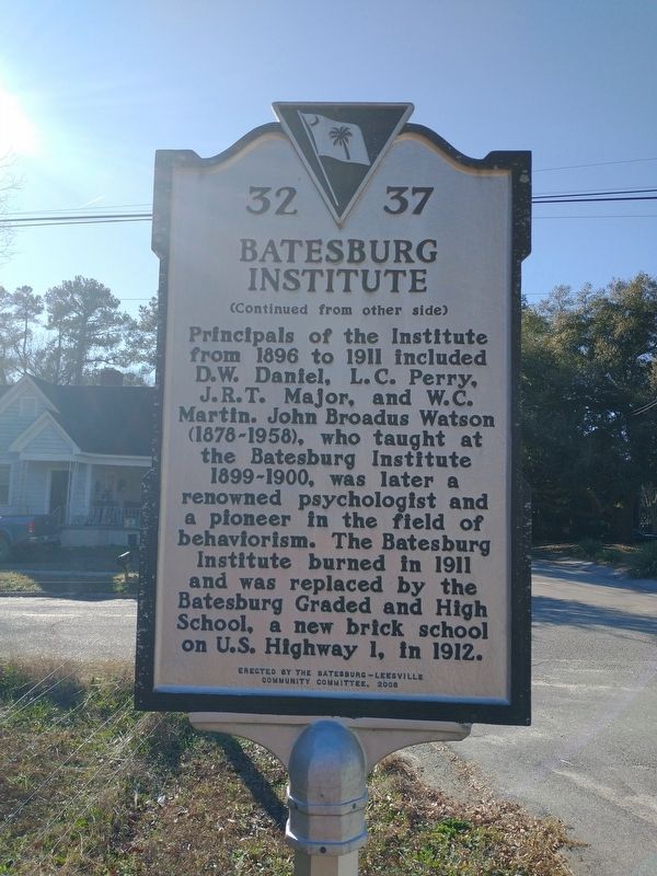
(Front) The Batesburg Institute opened here in 1893. Also called the Batesburg Collegiate Institute, it was created by the merger of the town’s Methodist and Baptist schools, founded in the 1880s. The Institute moved into the Baptist school, a . . . — — Map (db m239262) HM
On Fulmer Street (South Carolina Route 23) at West Church Street, on the left when traveling north on Fulmer Street.
Sgt. Isaac Woodard, a black soldier, was removed from a bus in Batesburg and arrested on Feb. 12, 1946, after a dispute with the bus driver. Woodard was beaten and blinded by a town police officer and the next day convicted in town court for “drunk . . . — — Map (db m239263) HM
On East Columbia Avenue (U.S. 1) west of Rose Street, on the left when traveling east.
This house was built before 1800 for John Pierson Bond, according to local tradition. It later came into the possession of John Bates, of the family for whom Batesburg derives its name, and has been owned for over a century by Lodwick Hartley and . . . — — Map (db m21880) HM
On East Columbia Avenue at Trackside Court (U.S. 1) on East Columbia Avenue.
Mills's Atlas of 1825 shows this site on the Augusta-Columbia road as the location of John W. Lee's Stage Tavern. According to local tradition, this vicinity was the probable site of President George Washington's breakfast stop on May 22, 1791. The . . . — — Map (db m21884) HM
On West Columbia Ave (U.S. 1) at Shealey Rd (County Highway S-32-47), on the right when traveling west on West Columbia Ave.
In 1921, the old Batesburg-Leesville High School, the first joint project undertaken by the two separate towns, opened at this site. Influenced by the Tudor Gothic Revival, the two-story brick structure was built for white pupils after the state . . . — — Map (db m173167) HM
On Fairview Road (U.S. 178) at Bagpipe Road, on the right when traveling south on Fairview Road.
Pinarea
Pinarea, the plantation owned by soldier, statesman, and manufacturer Paul Quattlebaum (1812-1890), was a mile E. Quattlebaum was a captain in the Seminole War and a brig. gen, in the S.C. militia by 1843. He was a state representative . . . — — Map (db m21869) HM
On West Columbia Avenue (U.S. 1) at Sulton Street, on the right when traveling east on West Columbia Avenue.
Site of the "Swamp Rabbit" Bridge A concrete highway bridge, built in 1928-29 when U.S. Highway 1 was paved through Batesburg, stood here until 2003. The 111-foot-long bridge, featuring graceful arches, spanned the track of the Sievern & . . . — — Map (db m240239) HM
On New State Road at Old State Road ( Highway 32-66), in the median on New State Road.
On February 15, 1865, as Gen. W.T. Sherman's Federal army advanced to Columbia, Gen. O.O. Howard's Army of the Tennessee found its way blocked by Confederates entrenched behind Congaree Creek and defending the Old State Rd. bridge. Gen. George G. . . . — — Map (db m39818) HM
On Wilkinson Street south of Poplar Street, on the right when traveling south.
Cayce Colored School. In 1927-28, a wood frame school was built on this site to house the Cayce Colored School. It served African American residents of Cayce and was part of the Brookland-Cayce School District. Grades 1-7 enrolled at the . . . — — Map (db m292219) HM
These earthworks were constructed in early 1865 and were the site of brisk fighting between the Union XV Corps and Confederate forces on Feb. 15, 1865. Approximately 750 enslaved and free African Americans who were impressed into Confederate . . . — — Map (db m229662) HM
On Charleston Highway (U.S. 176/321) near Between Dixiana Road and Old Dunbar Road, on the right when traveling north.
In 1718, at a site 2.7 miles east, near the place where the Cherokee Path crossed Congaree Creek, the first frontier outpost in central South Carolina was established under the command of Captain Charles Russell. The fort was abandoned in 1722, but . . . — — Map (db m21711) HM
Emily Geiger Heroine of the Revolutionary War captured while delivering secret message from Gen. Greene to Gen. Sumter held captive at Fort Granby July 3, 1781 — — Map (db m59067) HM
On Knox Abbot Drive at Axtell Drive, on the left when traveling west on Knox Abbot Drive.
Gift to the City of Cayce on March 13, 1961, by the heirs of John G. Guignard to be maintained as a public park in a state of natural beauty. This park established to conserve wild flowers, native shrubs and trees and to provide a place of quiet and . . . — — Map (db m59069) HM
On State Road (State Highway 2), on the right when traveling south.
This route follows an old Indian trail path and later in 1747 a public road from Charleston to Granby and points west. The State Road laid out by the newly established Board of Public Works in 1820 from Charleston to Columbia and on to the . . . — — Map (db m21697) HM
In 1775 the building upon the ground adjacent hereto was used as a store. Upon the fall of Charles Town in 1780 the British seized the store, fortified it, and established here "The Post at the Congarees." Attacked Feb. 19, 1781, by Gen. . . . — — Map (db m220367) HM
On State Road (State Highway 2) south of Indigo Avenue, on the right when traveling south.
1941 WWII 1946
A Tribute
to give our military veterans
the honor and respect due them
They hit the line and they hit it hard
They ran the ends of fame
They passed and kicked to distant goals
When . . . — — Map (db m22227) HM
On Dreher Road at Long Pine Road, on the right when traveling south on Dreher Road.
SC Gen. Assembly incorp. this Lutheran church 17 Dec. 1794. Frederick Josephus Wallern served as 1st pastor. Today's church, dedicated 1936 is the 3rd building. — — Map (db m21507) HM
On Oakey Springs Drive (State Road 32-100) west of Church Street, on the right when traveling west.
This church was constituted in 1824 as Sandy Run Baptist Church. Its charter members included eleven men and ten women who organized under the leadership of William Pauling, Jesse Hartwell, and others. They named the church after nearby Sandy Run . . . — — Map (db m292217) HM
On Lewie Street (State Highway 32-737) at Waters Ferry Road (State Highway 32-37), on the right when traveling east on Lewie Street.
(Front) Lewie Chapel, a Methodist church founded on this site in the 1870s by Solomon R. Lewie (1835-1878) and others, was later known as Lewiedale Methodist Church and after 1910 as Gilbert Methodist Church. The original sanctuary, replaced . . . — — Map (db m30372) HM
On Main Street south of Rikard Circle, on the left when traveling south.
A party of Sumter's soldiers, harassing a rear guard of British foragers under Lord Rawdon (en route to relieve besieged Ninety Six), was ambushed several miles north of here on June 18, 1871. The state troops, under Col. Charles S. Myddelton, were . . . — — Map (db m21894) HM
On St. Andrews Road at Palace Drive, on the right when traveling east on St. Andrews Road.
These four acres were conveyed to St. Andrew's Lutheran Church in 1835, and by November of that year the congregation had built and dedicated a building. It is believed that the community of St. Andrews derived its name from this church. In 1949, . . . — — Map (db m21532) HM
On Woodrow Street at Columbia Avenue, on the right when traveling south on Woodrow Street.
[Front]:
The Town of Irmo was established in a small farming community when the Columbia, Newberry and Laurens Railroad constructed its line here in february of 1890. The town was incorporated by the SC General Assembly in December of . . . — — Map (db m21525) HM
On Summerland Highway (State Highway 391) just south of Jeremiah Road. Reported missing.
On November 17, 1781, in a house near Cloud's Creek one mile east Captain Sterling Turner's Patriot militia were surrounded and massacred by Tory militia under Major William Cunningham. Among the more than twenty dead were Captain James Butler and . . . — — Map (db m265013) HM
On Old Lexington Road, on the right when traveling east.
(Front) Old Lexington Baptist Church, known originally as Saluda Baptist Church, was established in 1813. Worship here began, however, as early as the late 1700s when camp meetings were held nearby. Early services were held under a brush arbor and . . . — — Map (db m239265) HM
This c. 1850 building once stood north of the Saluda River in the Dutch Forks Pineridge area. Turned by one or two mules or horses, the wooden gears underneath powered the saw-toothed gin upstairs to extract seed from raw cotton. Working eight . . . — — Map (db m22042) HM
Near Fox Street south of Columbia Avenue (U.S. 378), on the right when traveling south.
This c. 1810 cottage was built on Bear Creek southeast of present Chapin by the family of Daniel Koon (1810-1876) who, with a secession of three wives, fathered 14 children. Self-taught, he spoke four languages and was well-known for his talent in . . . — — Map (db m137676) HM
Built c. 1820 by the Gross family and bought by
the Lutheran Synod in 1834, this house
served as home to the Lutheran Seminary's
headmaster, Dr. Ernest Hazelius, during that
school's location here 1834-1858. Theologian,
historian, . . . — — Map (db m21954) HM
Built on this site c. 1832, this vernacular farm house was home to the family of John Fox (1805-1884), whose plantation, The Point, was located 3 miles northwest of here. Fox served as Sheriff, Clerk of Court, Representative, and Senator for . . . — — Map (db m22026) HM
Near Fox Street, on the right when traveling south.
Built on this site c. 1832, this vernacular farm house was home to the family of John Fox (1805-1884), whose plantation, The Point, was located 3 miles northwest of here. Fox served as Sheriff, Clerk of Court, Representative, and Senator for . . . — — Map (db m22032) HM
This kitchen, built c. 1825 in Batesburg-Leesville by planter Joel Ridgell (1798-1870) whose second wife was a sister of John Fox, is almost identical to the kitchen that originally stood here from 1832 until demolished c. 1920. Each kitchen . . . — — Map (db m22034) HM
[Front]:
This log house was built ca. 1771 by Laurance Corley (1742-1815), whose plantation of over 1700 acres occupied much of present-day Lexington. Corley later served in Capt. Gabriel Friday's militia company during the Revolution. . . . — — Map (db m22010) HM
On Creps Street at East Main Street (U.S. 1), on the right when traveling south on Creps Street.
This church was constituted May 21, 1893, with ten charter members. The original one-room frame building, dedicated 1894 and located on land given by James C. Fort, was across Main Street about 600 feet east of here. The congregation of about 150 . . . — — Map (db m22198) HM
On South Lake Drive (State Highway 6) at East Main Street (U.S. 1), on the right when traveling south on South Lake Drive.
[Southeast]
Lexington's valiant
sons
who went forth to
battle for their
country's cause.
And gave their lives
in the service of the
Confederate States.
A.D. 1861-1865.
[Crossed Swords][List of Names]
To . . . — — Map (db m22182) HM
On South Lake Drive (State Highway 6), on the right when traveling south.
Obelisk
[South]
"I do not believe that the men who served in uniform in Vietnam have been given the credit they deserve. It was a difficult war against an unorthodox enemy."
Gen. Wm. C. Westmoreland
. . . — — Map (db m88502) WM
On South Lake Drive (State Highway 6) south of East Main Street (U.S. 1), on the right when traveling south.
[Southeast]
A tribute
to the
soldiers, sailors,
and marines
of
Lexington County
who gave their lives
in
the World War.
1917 ----- 1918
[Northwest]
African-American Veterans
Allen, James A.; Buzard, Fred; . . . — — Map (db m22184) HM
On East Main Street (U.S. 1) at South Lake Drive ( Highway 6), on the right when traveling south on East Main Street.
On this site or close by have stood five courthouses of Lexington District or County. In 1820 Barbara Corley deeded land in the present town for a centrally located courthouse. A later ante-bellum building was burned Feb. 17, 1865 by Sherman. Two . . . — — Map (db m22053) HM
(Front) The Lutheran Classical and Theological Seminary was located here from 1834 to 1855. The Synod of S.C. established a new seminary in 1831 in an effort to promote the education of Lutheran ministers in the southeast. It opened in Pomaria, . . . — — Map (db m239267) HM
On Cromer Road at English Drive, on the right when traveling west on Cromer Road.
This is the former site of Oak Grove Colored School, est. 1900 as a public school for African Americans. It was built on a lot previously owned by John Sewell (1831-1915), a Black farmer who lived nearby. He conveyed the land to school trustees . . . — — Map (db m292445) HM
This old field-school was built c. 1815 in the Oak Grove area approximately five miles east of here. Typical of early educational facilities in South Carolina, it was a private community school somewhat subsidized with state funds from the Free . . . — — Map (db m22012) HM
On North Church Street at East Butler Street, on the right when traveling north on North Church Street.
Around 1888 near this site,
Charles D. Tillman was
conducting a tent revival
and first heard the
local Negro spiritual
"Old Time Religion."
Tillman had the song leader
assist him in notating the
music and lyrics. It is now
seen in . . . — — Map (db m22199) HM
Built c. 1790 as a lawyer's office at Granby on
the Congaree River, this building was rolled to
the new county seat called Lexington Courthouse
in 1820 and was used as a medical office for Dr.
Thomas Simmons (1794-1853). His widow,
Mary, . . . — — Map (db m21937) HM
On Old Chapin Road at Whisperwood Drive on Old Chapin Road.
Lutheran church said est. 1862. Admitted to the synod 1866. Present remodeled building, built by 1869, is on land deeded church by Jacob Rauch family. — — Map (db m21936) HM
On Lake Shore Drive (State Highway 6) north of Nazareth Rd (County Highway 32-243), on the right when traveling south. Reported missing.
Skirmish at Red Bank Creek. On February 15, 1865 Gen. Henry W. Slocum's Army of Georgia, the left wing of the Federal advance toward Columbia, marched along this route toward Lexington. The Federals, led by skirmishers of the 28th Pennsylvania . . . — — Map (db m265014) HM
On North Church Street at West Butler Street, on the left when traveling north on North Church Street.
This Lutheran Church, founded by 1830, and the earliest church in Lexington, dedicated its first-known house of worship on this site in 1831. In 1865 Union troops under Wm. T. Sherman burned the structure. The congregation's second building, . . . — — Map (db m22208) HM
On Tarrar Springs Road 0.1 miles north of Augusta Road (U.S. 1), on the left when traveling north.
At this location on Nov. 16, 1781 Patriot militia under Capt. Sterling Turner met Tories under Col. Hezekia Williams as part of Maj. William Cunningham’s “Bloody Scout” raid. The Tories had stolen a herd of cattle in the Mt. Willing area of . . . — — Map (db m239268) HM
On U.S. 1 just west of Timbermill Road, on the left when traveling south.
This tree was planted from a cutting of the old sycamore tree that stood several hundred feet west of here on the historic Two Notch Road. Local tradition holds that there had been a succession of sycamore trees at that site used as a landmark or . . . — — Map (db m47549) HM
On West Butler Street near 119 North Church Street, on the right when traveling north.
At this site is the grave of the Reverend Ernest L. Hazelius, 1777-1853, Lutheran clergyman, Doctor of Divinity, teacher, and author of several books on church history and theology. From 1834 to 1853, he was professor of theology in the Lutheran . . . — — Map (db m238312) HM
On North Lake Drive (State Highway 6), on the right when traveling south.
[Front]:
Lake Murray islands, most notably Lunch Island (since 1945 also called Bomb Island or Doolittle Island), Shull Island, and Dreher Island, were used as bombing ranges during World War II. B-25 crews from the Columbia Army Air . . . — — Map (db m21535) HM
On Corley Mill Road, on the left when traveling south.
Zion Lutheran Church
This congregation, the oldest continuing church in Lexington County, originated with pioneers who settled in this area in the 1740s. Organized at Zion in 1787 was the "Corpus Evangelicum," consisting of fifteen . . . — — Map (db m21558) HM
On St. Peter's Church Road, on the right when traveling north.
This church, organized in 1780, held services in German and English until 1874. In 1835 it aligned with the Tennessee Synod and remained in it until 1922, when St. Peter's reunited with the South Carolina Synod. This 1953 sanctuary is the fourth . . . — — Map (db m46123) HM
On Fish Hatchery Road (State Highway 32-73), on the right when traveling north.
This military post, also known as Camp Styx,was begun here in 1913 as a National Guard training center. The base sent men to a Mexican border disturbance after Pres. Woodrow Wilson mobilized the guard, 1916. The 1st Infantry Regiment, later the . . . — — Map (db m39078) HM
Dedicated to the Memory of
Herman Geiger
Father ~ Hans Jacob Gyger, Born 1679, at village of Wydnau, Parish of Diapololsau, Switzerland. Mother ~ Margareta Fearin Gyger of same place, born 1684. Herman Geiger (Gyger) Born (or Christened) . . . — — Map (db m52469) HM
On Platt Springs Road (State Highway 602) at Springdale Road, on the right when traveling west on Platt Springs Road.
This community, which was incorporated as Springdale in 1955, was known as Long Branch for many years and named for a nearby branch of the Congaree River. At the turn of the twentieth century it was a farming community along both sides of Platt . . . — — Map (db m39160) HM
On Main Street (State Highway 178) at Whetstone Road (Highway 3), on the left when traveling east on Main Street.
Erected as a log structure, Jeffcoats' Meeting House was a Wesleyan meeting house and school to Big Pond Branch, a small community along a branch of the north fork of the Edisto River in an area known as The Indian Head. This meeting house was . . . — — Map (db m102964) HM
On South Church Street (U.S. 321) north of South Church Street, on the right when traveling south.
This is the first permanent site of Mount Olive African Methodist Episcopal (A.M.E.) Church. Church leaders acquired this site from Hilliard and Joanna Goodwin in 1899, a few years after the Town of Swansea was chartered. Congregants organized . . . — — Map (db m292216) HM
Near Alexander Road, on the right when traveling north.
Anchor from C. S. N. “City of Columbia” ---------- Donated by Mrs. Lemuel Hall In memory of Lemuel Hall Mayor of West Columbia for 24 years — — Map (db m67489) HM
On Airport Boulevard south of Air Commerce Road, on the right when traveling south.
Activated in 1942 and stationed here at Columbia Army Air Base February through April of 1945, the 319th participated in many World War II campaigns in Europe and the Pacific. The group has received numerous honors, including two Presidential . . . — — Map (db m10741) HM
On Airport Boulevard south of Air Commerce Drive, on the right when traveling south.
The 345th Bombardment Group of the 5th Air Force, the "Air Apaches," served in the Southwest Pacific during World War II. Four squadrons (the 498th, 499th, 500th, and 501st) trained here at Columbia Army Air Base November 1942-April 1943, with . . . — — Map (db m239273) HM
Near Botanical Parkway east of Mohawk Drive, on the right when traveling east.
As Riverbanks continued to grow and evolve, drawing more people to the Garden became a priority, and what better way to do so than by creating a dedicated space to engage children and families. In April 2016, Waterfall Junction opened to the . . . — — Map (db m292313) HM
On Airport Boulevard south of Air Commerce Road, on the right when traveling south.
In 1942 the 310th, 321st, 340th groups trained here at Columbia Army Air Base for World War II.
All participated in 9 campaigns and each received 2 Distinguished Unit Citations. — — Map (db m10901) HM
On Airport Boulevard near Air Commerce Road, on the right when traveling east.
Columbia Army Air Base. Built during 1941 as the Lexington County Airport, this airfield became the Columbia Army Air Base shortly after the U.S. entered World War II in December, 1941. The base was used to train crews for
medium . . . — — Map (db m10680) HM
On Sunset Boulevard (U.S. 378) at Pony Hill Road, on the right when traveling east on Sunset Boulevard.
From 1900 until 1916 Lexington County School District No. 68 operated a public school on this site. The building consisted of a single room where one teacher taught an average of 30 students of all grades. — — Map (db m69553) HM
Near Alexander Road, on the right when traveling north.
This ferry was named after the German settler Martin Fridig, who changed his name to Friday. He came to the area about 1735. In 1754 Friday received permission from the Colonial assembly in Charleston to operate a ferry across the Congaree near . . . — — Map (db m67762) HM
Near Alexander Road, on the right when traveling north.
This 1,412-foot-long arch bridge opened in 1927. At the time, the bridge was considered exceptional because of its innovative use of reinforced concrete and because it was the widest roadway in South Carolina. The Gervais Street Bridge was the only . . . — — Map (db m67761) HM
On Old Wire Road east of Glenn Road, on the right when traveling west.
Tradition holds that congregants of St. Paul Church organized in the 1870s and originally worshipped under a brush arbor. By 1884 members had built a church approx. 2 mi. E, near the Congaree River. They purchased that 1/2-acre lot for $3.00 from . . . — — Map (db m292424) HM
On Batchelor Street west of North Street, on the right when traveling west.
Formerly known as New Brookland School, Lakeview began as a three-room building with one teacher educating African-American students in grades one through six.
By 1937 New Brookland School was rebuilt and renamed Lakeview High School because . . . — — Map (db m291958) HM
On Batchelor Street west of North Street, on the right when traveling west.
This was the last site of a segregated school for Black residents of Brookland-Cayce School District with roots to at least the 1900s. First called the Brookland or New Brookland Colored School, is was located on Lacy Street by c. 1931 when it . . . — — Map (db m291769) HM
Near Alexander Road, on the right when traveling north.
A milestone was one of a series of numbered markers placed along a road or other type of boundary at intervals of one mile, or occasionally, parts of a mile. These stone markers indicated either the distance traveled or the remaining distance . . . — — Map (db m67771) HM
On Leaphart Road at Hebron Drive, on the right when traveling west on Leaphart Road.
Mt. Hebron United Methodist Church
This congregation, organized ca. 1800 in the home of Martin Hook, built its first house of worship at the Half Way Ground, near here. In 1837 a new church was erected at this site on land donated by John and . . . — — Map (db m21598) HM
Near Alexander Road, on the right when traveling north.
Before a bridge was attempted at this location, earlier bridges farther down river had been built, but were washed away in floods. Consequently, for more than 30 years only ferry service provided transportation across the river. In 1827 the . . . — — Map (db m67766) HM
Near Alexander Road, on the right when traveling north.
“The transacting of Public Business on Saturdays … are executed at Taverns [where] there is more Company of a Saturday, than in the Church on Sunday.”The Rev. Charles Woodmason. “Sermon at the Congarees.” C. . . . — — Map (db m67758) HM
On Sunset Boulevard (U.S. 378) at Botanical Pkwy on Sunset Boulevard. Reported missing.
One mile east on the Saluda River stood a 4-story granite building erected by the Saluda Manufacturing Company, incorporated in 1834. Operated by slave labor, it was, at one time, the largest cotton factory in the State. Burned by Sherman Feb. 17, . . . — — Map (db m265012) HM
On Botanical Parkway near Saluda Mill Drive, on the right when traveling west.
This cemetery, thought to contain graves of supervisors and workers in the post-Civil War community of Saludaville, includes 31 marked graves and between 525 and 900 total burials. The Saluda Factory was a modest success before the war and was . . . — — Map (db m39236) HM
The Saluda Factory, built in 1834, was one of the first water-powered textile mills in South Carolina.
During the Civil War the mill manufactured material used in making shirts and woolen uniforms for the Confederate Army.
This area saw . . . — — Map (db m45045) HM
On Sunset Boulevard (U.S. 378) at North Lucan Street, on the left when traveling east on Sunset Boulevard.
Prior to the capture of Columbia by Gen. William T. Sherman, Federal artillery shelled the city on February 16, 1865, from the batteries on this hill and in the road at this end of the Congaree River bridge. Shots were fired at the Arsenal (site of . . . — — Map (db m21652) HM
On Augusta Road (U.S. 1), on the right when traveling north.
Before the Revolution, two major trading routes came together near here. Branching to the west was the road to New Windsor Township on the Savannah. The Cherokee Path extended north to Ninety Six and south through Saxe Gotha Township on the . . . — — Map (db m43791) HM
On Boston Avenue at West Campus Road, on the right when traveling west on Boston Avenue.
In 1921, Wil Lou Gray (1883-1984), State Supervisor of Adult Education, founded the first "Opportunity School" in Tamassee, S.C., after launching a series of night schools to eliminate adult illiteracy. An experimental residential program, the . . . — — Map (db m292443) HM
On River Road (South Carolina Route 32-38) at St. Michael Lane, on the right when traveling west on River Road.
St. Michael Lutheran Church organized in 1814 with members who came from nearby Zion and Bethel Churches. The desire to conduct services in the English language, rather than the German of early Dutch Fork settlers, led them to found this . . . — — Map (db m300165) HM
On Boney Road (State Road 40-1367) north of McNulty Street, on the left when traveling north.
Bethel School. As early as 1908, Bethel School, also known as Blythewood Colored School, opened on land tradition says belonged to Bethel Baptist Church. In c. 1920, the school moved into a two-teacher building built on this site with support . . . — — Map (db m292446) HM
On McNulty Road near Boney Road, on the right when traveling west.
Bethel Baptist Church was founded in 1884 by black members of nearby Sandy Level Baptist Church seeking to organize a separate congregation. They met at first in a brush arbor, then built a frame sanctuary here in 1892. It was covered in granite . . . — — Map (db m43391) HM
On Main Street / Wilson Boulevard (U.S. 21), on the left when traveling north.
The first school built here c.1890 was a two-room frame building that was replaced c.1918 by a two-story brick school. In 1921 another classroom building and an auditorium were added. The federal Works Progress Administration helped fund several . . . — — Map (db m138341) HM
On Longford Road (State Highway 40-54), on the left when traveling east.
This house was built ca. 1855 for George P. Hoffman (1829-1902), a native of N.C. Hoffman ran a nearby sawmill and became the first postmaster of Doko (as Blythewood was first known) in 1856. This area was part of Fairfield County until 1913, . . . — — Map (db m42607) HM
On Winnsboro Road, on the left when traveling north.
The congregation at Little Zion dates to c. 1832, when enslaved individuals worshipped in white-controlled churches. After emancipation, these former slaves founded independent congregations like this one. A group led by Doctor Entzminger . . . — — Map (db m123500) HM
On N. Melton Road, (Sandfield Road) near Russ Brown Road, on the right when traveling east.
Sandfield Baptist Church. Twenty-Five Mile Creek Church, a Primitive Baptist congregation, was organized in this area before 1772. It was renamed Sandfield Church by ca. 1830 and the mother church for Cedar Creek, Harmony, Jackson Creek, and . . . — — Map (db m43103) HM
On Blythewood Road (State Highway 40-59) near Locklier Road, on the right when traveling west.
Twenty-Five Mile Creek Church, a Primitive Baptist congregation, was organized in this area before 1772. The mother church for several area Baptist churches, it was renamed Sandfield ca. 1830 and stood about 3 mi. E. Sandfield Baptist Church was . . . — — Map (db m42996) HM
Educator and civil rights leader Benjamin Mack (1916-1970) lived in this house from the late 1950s until his death in 1970. Mack was a graduate of Booker T. Washington H.S. and S.C. State Univ. He taught at Lower Richland H.S. in the 1940s where he . . . — — Map (db m124523) HM
On Daniel Street near Willingham Drive, on the right when traveling west.
This church was organized in 1835 in what was then rural Richland District. The first sanctuary here, built soon afterwards, burned in a forest fire in 1867; the cemetery dates from as early as 1862. The second sanctuary, built in 1868, was . . . — — Map (db m43709) HM
On Atlas Road at Bible Way, on the right when traveling east on Atlas Road.
This church, founded in 1963, was originally about 3 mi. NW on Bluff Road. It was organized by Elizabeth Simmons (1900-1965), known as "Mother Simmons," Andrew C. Jackson (1927-2006), and eleven other adults and their children. The first church, . . . — — Map (db m292427) HM
On Devine Street (U.S. 76/378) at Wildcat Road, on the right when traveling west on Devine Street.
Named in honor of Gen. Andrew Jackson. This cantonment site 1 ½ mi. north was approved by the War Dept. June 2, 1917. Maximum strength was recorded in June 1918: 3,302 officers; 45,402 men. 81st Division was trained here Aug. 29, 1917-May 18, . . . — — Map (db m30740) HM
On Two Notch Road 0.2 miles north of North Chelsea Road, on the right when traveling north.
On June 16th, 1961, African American students from Allen University and Benedict College courageously challenged segregation at Sesquicentennial State Park, including the swimming area before you. Led by Rev. I. DeQuincey Newman, South Carolina . . . — — Map (db m273909) HM
On Two Notch Road 0.2 miles north of North Chelsea Road, on the right when traveling north.
Does this building look radical to you? It was in the 1930s!
Civilian Conservation Corps projects typically used native materials like stone, cypress, and pine for construction. But builders proposed something new for this bathhouse — . . . — — Map (db m274026) HM
On Westminster Drive at Stratford Road, in the median on Westminster Drive.
Known as "Diamond Hill," which was burned by Union Troops during their invasion of Columbia, February 17, 1865, was located 125 feet due south of this spot.
The stones in this monument formed part of the foundation of that home. — — Map (db m46448) HM
Near Wildlife Parkway south of Rivermont Drive, on the left when traveling south.
Saving Animals from Extinction
Riverbanks is a member of the Association of Zoos and Aquariums' Saving Animals from Extinction (SAFE) Program. SAFE is designed to strategically harness the collective power of the AZA and its members to . . . — — Map (db m292315) HM
On Forest Drive (State Highway 12) at North Beltline Blvd (State Highway 16), on the right when traveling west on Forest Drive.
In this malaria-free sandhill section were the antebellum summer homes of many Columbians: Quinine Hill (Dr. J. M. Taylor, Dr. James Davis); Hilltop (W. J. Taylor); Edgehill (B. F. Taylor); Laurel Hill (D. J. McCord); . . . — — Map (db m30246) HM
On Two Notch Road (U.S. 1) near North Brickyard Road. Reported missing.
Lightwood Knot Springs, situated about two miles north, a popular summer resort during the first half of the nineteenth century, was later Confederate training camp for recruits. A few miles east was Rice Creek Springs, another early summer resort . . . — — Map (db m265134) HM
On Forest Drive (State Highway 12), on the right when traveling east.
About 1800, Col. Thomas Taylor erected the small building, ¼ mile upstream, where cotton goods were woven for his plantation needs. Here John and Edward Fisher later established one of the earliest spinning mills in Richland County, using slave . . . — — Map (db m30454) HM
On George Rogers Boulevard at Bluff Road ( Route 48), on the right when traveling east on George Rogers Boulevard.
George Rogers enrolled at the University of South Carolina in 1977 and became one of the greatest football players in school history. In 1980, Rogers received the Heisman Trophy and holds the distinction of twice finishing in the Top 10 in . . . — — Map (db m292440) HM
On Chappelle Street near Lorick Road, on the right when traveling north.
Front
Isaiah DeQuincey Newman (1911~1985), Methodist minister, civil rights leader, and state senator, lived here from 1960 until his death. Born in Darlington County, he attended Claflin College and was a graduate of Clark College and . . . — — Map (db m57481) HM
580 entries matched your criteria. The first 100 are listed above. Next 100 ⊳