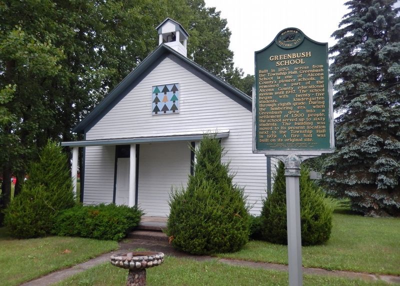
On Campbell Street west of State Street, on the right when traveling west.
Built in 1870, across from the township hall, Greenbush School is one of Alcona County’s pioneer schools. It remained a part of the Alcona County educational system until 1947. The school began with twenty-five students, kindergarten through . . . — — Map (db m121967) HM
On North Lake Street 0.1 miles north of East Main Street, on the left when traveling north.
The first issue of the Alcona County Review was published on April 27, 1877 by publisher James K. Fairchild. Nine publishers and 140 years later, the Review is the oldest continuously run business in Alcona County. Throughout all of . . . — — Map (db m121971) HM
On Point Road east of Sturgeon Trailways Road, on the left when traveling east.
In the mid-1800s the first white settlers came to what is now Alcona County. As the population grew, schools became part of nearly every settlement or logging camp. The first school was built in 1860. In 1869, Alcona County was established but . . . — — Map (db m277850) HM
Near North 5th Street just north of West Jefferson Street, on the right when traveling north.
This bell marks the site of the beloved red brick schoolhouse on the hill. Proud alumni and loyal friends dedicate this memorial to those who taught and learned from morning ring to closing toll. The bell symbolizes love, laughter and learning of . . . — — Map (db m154630) HM
On East Dock Street 0.1 miles east of North Lake Street, on the left when traveling east.
In 1883, Russell Alger formed the Detroit, Bay City and Alpena Railroad. In 1895 it was combined with the Alpena and Northern to form the Detroit and Mackinaw Rail Company. In 1900 depot sites were selected at Greenbush and Harrisville. Scheduled . . . — — Map (db m121975) HM
On East Main Street east of North Lake Street, on the left when traveling east.
In September 1846, fisherman Simeon M. Holden and his boat's crew, Robert McMullen and William Hill, were driven by a northwest gale from their fishing ground at Thunder Bay Island and made land at the High Banks of AuSable, now called Springport. . . . — — Map (db m277372) HM
On West Main Street (Michigan Route 72) at North State Street (U.S. 23), on the right when traveling west on West Main Street.
Erected by the Women's Civic League of Harrisville in memory of our boys who
sacrificed their lives in the Great World War.
Percy Anderson •
John E. Armstrong •
Delbert Atchison •
Harvey G. Alexander •
Asa Baird •
Ernest R. Berry . . . — — Map (db m277399) WM
On Point Road east of Spruce Trailways Road, on the left when traveling east.
This anchor windlass was mounted on the forward deck of large sailing vessels to raise their heavy anchors. It was mounted in a strong frame and used a rachet device to rotate the shaft to lift and recover
the anchors and lines. — — Map (db m277857) HM
On Point Road east of Spruce Trailways Road, on the left when traveling east.
Built in 1907 of Norway pine, the Bailey School is one of the few remaining one-room, log schoolhouses still standing in Michigan. It was built at the site of
the C.A. Johnson Logging Camp west of Mikado for the children of the logging crews, and . . . — — Map (db m277568) HM
Near Point Road east of Sturgeon Trailways Road, on the left when traveling east.
The history of the Great Lakes is dominated by tales of majestic schooners and gigantic freighters battling storms. Working in the shadows of these larger ships, thousands of small workboats tolled in every corner of the Great Lakes. They
were . . . — — Map (db m277671) HM
On Point Road east of Spruce Trailways Road, on the left when traveling east.
(On Left)
The Capstan is an apparatus which
is mounted on thenforedeck of a ship to raise anchors and handle other heavy loads. This one was operated by hand using bars inserted in the holes at the top.
Damage suggests this one failed under . . . — — Map (db m277965) HM
On Point Road east of Spruce Trailways Road, on the left when traveling east.
Get Into Your Sanctuary
Sanctuary Sentinels
As the nation's population and economy rapidly expanded throughout the 19th century, so did the shipping traffic on the Great Lakes. Violent storms, thick fog, shifting sandbars, rocky . . . — — Map (db m277968) HM
Near Point Road near Spruce Trailways Road, on the left when traveling east.
According to the Detroit Tribune, the tug Loretta "was always considered an unlucky boat, having been in dry dock every season since coming out." On the morning of October 7, 1836, the Loretta was awaiting repairs at Black River when a . . . — — Map (db m277860) HM
On Point Road east of Spruce Trailways Road, on the left when traveling east.
On August 29, 1880, the sidewheel passenger vessel Marine City steamed across Lake Huron. While just off Sturgeon Point, passengers and crew noticed smoke
coming from the engine room. In very little time, the fire engulfed the ship. As thick . . . — — Map (db m277836) HM
On Point Road east of Spruce Trailways Road, on the left when traveling east.
After stopping for a load of shingles at Alcona the ship caught fire three miles off shore from Sturgeon Point. The fateful day was Aug. 29, 1880.
The tugs Vulcan and Grayling came to the rescue. Approx. 100 passengers, 41 crewmen leaped into . . . — — Map (db m277845) HM
On Point Road east of Spruce Trailways Road, on the left when traveling east.
This tug caught fire at the dock of the Alger Smith lumber mill in Black River, Mi., circa 1890. It was pushed away from the dock where it sank. — — Map (db m277854) HM
Near Point Road east of Sturgeon Trailways Road, on the left when traveling east.
This is a gasoline powered fishing boat typical of many used on the great lakes in the first half of the 20th century. Fishing for lake trout, white fish and other species was a major industry from the early 19th century until the sea lamprey, an . . . — — Map (db m277606) HM
On Dune Lane near Alcona Road and North Lake Shore Drive.
Circa 1845, William Hill established a fishery at this place,
which was called The Cove. He had five fishing boats and a
lodging house. The settlement became the village of Alcona.
In the 1860s and 1870s, Johnston, Haynes & Company built
a saw . . . — — Map (db m233580) HM
William Hill established a fishing
station in this area. known as "the
Cove." circa 1853. Early residents
were fishermen who netted the once
abundant schools of herring.
whitefish and perch. Johnson, Haynes
and Co. began lumbering the . . . — — Map (db m233566) HM
On Point Road east of Spruce Trailways Road, on the left when traveling east.
This bell was originally mounted in
the Watchtower from which the Coast Guardsmen at Sturgeon Point maintained a dawn-to-dusk lookout for vessels in trouble out on the Lake. If a vessel in distress was spotted the man on duty would ring the bell to . . . — — Map (db m277674) HM
Near State Highway 28 1 mile east of Arbutus Street (Autrain Forest Lake Road), on the left when traveling east.
The sculpture to the right replicates a rock carving as made in 1820 by a French trapper and guide who accompanied Lewis Cass, governor of the Michigan Territory. Cass was on an expedition along the south shore of Lake Superior on his way to what . . . — — Map (db m154477) HM
Near State Highway 28 1 mile east of Arbutus Street (Autrain Forest Lake Road), on the left when traveling east.
Le lac supérieur the French called it, meaning only that geographically it lay above Lake Huron. In size, however, Lake Superior stands above all other freshwater lakes in the world. The intrepid Frenchman Brulé discovered it around 1622. . . . — — Map (db m41968) HM
On Autrain Forest Lake Road 2.2 miles south of State Highway 28, on the right when traveling south.
Swedish pioneer Charles Paulson purchased one hundred acres of land here in 1884 and constructed this cabin for his family home. Built of hand hewn cedar logs securely dovetailed at the corners, the house was occupied by Paulson and his wife until . . . — — Map (db m206179) HM
Near State Highway 28 1 mile east of Arbutus Street (Autrain Forest Lake Road), on the left when traveling east.
The Grand Island Nishnaabe had many of their spring, summer, and fall needs met on the island, but they also visited the mainland for seasonal foods and hunting. Sand Point provided luscious cranberries. The Anna River and other streams provided . . . — — Map (db m154478) HM
On Arbutus Street at Route 28, on the right when traveling north on Arbutus Street.
AuTrain, a French term meaning "at the shortcut or traverse" was one of the earliest sites visited by white men as they travelled along Lake Superior's
south shore. The river was part of an ancient Indian route between Lakes
Supurier and . . . — — Map (db m278428) HM
Bay Furnace is all that remains of Onota, an iron-making settlement destroyed by fire in 1877.
Signs along the trail tell the story of this historic blast furnace. length: 1/8 Mile loop — — Map (db m226620) HM
Pioneer iron-makers built here because the curving shoreline and offshore islands create a protected harbor for ships. The logs you see along the beach remain from a dock that was once 1,200 feet long. The surrounding maple and beech trees . . . — — Map (db m226623) HM
Bay Furnace was abandoned in 1877. Over the next century the upper portion crumbled and the unique arches were in danger of collapse. The USDA Forest Service stabilized the remaining ruins in 1992 to prevent additional damage. "Time takes a . . . — — Map (db m226635) HM
On Log Slide Road north of County Route H58, on the right when traveling north.
This area was logged in the late 1800's for the large white and red pine and white cedar. Then, in the 1930's and 40's the virgin hardwoods were logged. After the initial logging era, much of the land was tax delinquent and reverted to the State of . . . — — Map (db m226638) HM
White pine, cedar, and hardwood logging led to early development of the region. The Upper Peninsula logging industry of the late 1800's and early 1900's has been romanticized in lore and story, in written and oral histories. Men like Wellington . . . — — Map (db m226824) HM
On Grand Marais Avenue (County Road H-58) at Randolph Street and Crawford Street, on the right when traveling north on Grand Marais Avenue.
This type of anchor was in use before the discovery of America, and
was common on the Great Lakes up to the end of the sailing era. Old
sailing schooners carried them, and these boats saw many more years’
usefulness on the Great Lakes after their . . . — — Map (db m253828) HM
On Grand Marais Avenue (County Road H-58) at Randolph Street and Crawford Street, on the right when traveling north on Grand Marais Avenue.
Grand Marais, which is among Michigan’s oldest
place names, received its name from French
explorers, missionaries, and traders who passed
here in the 1600’s. “Marais” in this case was a
term used by the voyageurs to designate a
harbor of . . . — — Map (db m253826) HM
For as much as a village is made up of its people, it is also the spaces they gather.
In 2009, a group of determined Grand Marais residents donated much time and effort and raised the funds necessary to purchase this Greenspace located in . . . — — Map (db m290702) HM
On Randolph Street at Crawford Street and Grand Marais Avenue (County Route H-58) on Randolph Street.
William A. Abrahamson •
Walter Aho •
Beverly Hugg •
Mark Barnly •
Francis H. Bleckiner •
Vernon L Beeckiner •
Dr. J. R. Boland •
James Buckland •
Isaac R. Carpenter •
Donald Carpenter •
Peter G. Carpenter •
Rufus Garrigan •
Forrest . . . — — Map (db m255245) WM
On Randolph Street at Lake Avenue ( Route 77), on the right when traveling east on Randolph Street.
Pickle Barrel House.
The Pioneer Cooperage Company of
Chicago designed this small vacation
cottage, which stood on the shores
of nearby Sable Lake from 1926 until
about 1937. It was built for William
Donahey, creator of the . . . — — Map (db m253838) HM
Near Miners Castle Road north of Miners Beach Road.
It seems the only constant in this world is change! No two views of the Pictured Rocks cliffs are the same. Erosion by wind, water, and ice is a continuous, ongoing process.
Two good examples of change in the 20th Century include the . . . — — Map (db m226681) HM
Near Miners Castle Road north of Miners Beach Road.
What Does Miners Castle Mean to You?
It may depend on who you are...
Anishnabeg or Ojibwa people have lived in this area thousands of years. The Pictured Rocks cliffs hold great spiritual significance as a place where the Manitous . . . — — Map (db m226703) HM
Near Miners Castle Road near Miners Beach Road (County Route H11).
In the Ojibwa language, Munising is "Kitchi-Minissing" or "place of the island." Grand Island, the largest on Lake Superior's south shore, has a rich history.
From here, you can see "the thumb" and the eastern side of the main portion of the . . . — — Map (db m226652) HM
Bedrock in the Lakeshore consists of three lavers of relatively soft sandstone. It overlays two-billion year old volcanic and metamorphic rocks visible at the surface to the north and west. At Marquette, quartzite, diorite, and slate are . . . — — Map (db m231031) HM
Yesterday The Schoolcraft Blast Furnace manufactured pig iron at this site for nearly ten years, beginning in 1868. Steam engines powered by water from Munising Creek provided the "blast" (hot
air) needed to turn iron ore, limestone, and . . . — — Map (db m226604) HM
Near Elm Avenue 0.1 miles north of East Munising Avenue (State Highway 28), on the right when traveling north.
With the discovery of iron ore in Marquette County in 1844 and the opening of the Sault Locks in 1855, commerce and travel boomed on Lake Superior. Munising served not only as a port, but also as a harbor of refuge during storms. The first . . . — — Map (db m143346) HM
On Elm Avenue at East Chocolay Street, on the right when traveling north on Elm Avenue.
Feb. 27 1836 – Jan. 24 1906 Brevet Major General U.S.V. Governor of Michigan Secretary of War United States Senator for whom this county is named — — Map (db m131695) HM WM
On East Superior Street at Elm Avenue, on the right when traveling east on East Superior Street.
The maritime artifacts displayed in this community fountain were salvaged from the S.S. Kiowa - a steel freighter built in 1920 by the Detroit Shipbuilding Company. S.S. Kiowa measured 251 feet in length, 43 feet in beam, 24 feet in depth, . . . — — Map (db m278450) HM
Near Elm Avenue 0.1 miles north of East Munising Avenue (State Highway 28), on the right when traveling north.
Local divers Pete Lindquist, Chuck Nebel, Tom Bathey, and John Stillman recovered this large anchor found buried in the sand of Munising Bay in 1980. The anchor is estimated to weigh over 1500 pounds. The anchor may have been lost by the barque . . . — — Map (db m154896) HM
On Sand Point Road near Washington Street, on the left when traveling north.
The Munising Coast Guard Station at Sand
Point opened in 1933 and closed in 1961. Photo to the right circa 1944
The official quarters building in front of you is now headquarters for
Pictured Rocks National Lakeshore.
The building . . . — — Map (db m226606) HM
On Au Sable Point Trail (County Road H-58) 1.9 miles east of Sullivans Landing, on the left when traveling east.
When Pictured Rocks National Lakeshore was authorized by the U.S. Congress in 1966 as America’s first
national lakeshore, the enabling legislation called for
the construction of a “scenic shoreline drive” as part
of the park’s development. . . . — — Map (db m253843) HM
On Traunik Road (County Road H-44) at E T Road (County Road H-01), on the left when traveling east on Traunik Road.
Traunik was the heart of
a large ethnic community
that developed in the early
1900s, when Slovenians
who cut timber settled on
the cut-over land. This
store, built in 1922–23,
was purchased by Louis
Mikulich in 1925. Mikulich’s
store was . . . — — Map (db m253855) HM
On Traunick Road (County Route H-44) just west of E T Road (County Route H-01), on the right when traveling west.
To this place they came, beginning in 1912, and
when enough had gathered to form a community, they
named it Traunik, which means "meadow" in Slovenia,
the country they left in search of a better life.
They brought with them a willingness . . . — — Map (db m253852) HM
On Chestnut Street at Hubbard Street, on the right when traveling south on Chestnut Street.
Allegan County's name was coined by the noted student of the Indians, Henry Schoolcraft. The county was set off in 1831 and organized in 1835. Settlement of the county seat, Allegan, was promoted in 1835 by eastern capitalists who were attracted by . . . — — Map (db m69891) HM
On North Walnut Street 0.3 miles south of Trowbridge Street, on the right when traveling south.
Michigan semicentennial organization this plaque is issued by the Historical Society of Michigan in recognition of the Allegan County Historical Society founded in 1954. For more than 50 years of continuous operation in service to the people of . . . — — Map (db m258814) HM
On Walnut Street at Hubbard Street, on the right when traveling south on Walnut Street.
On June 15, 1858, the Episcopal Church of the Good Shepherd was organized; its parish was admitted into the Diocese of Michigan two years later. Built in 1866-69, this Gothic structure was designed by Gordon W. Lloyd and first used for Divine . . . — — Map (db m69890) HM
Near Brady Street east of Riverfront Plaza, on the right when traveling east.
By resolution of the Allegan City Council, this park is dedicated to the memory of
JAMES E. MAHAN, M.D.
1895–1984
Dr. Mahan ministered to the needs of the Allegan area -- both in the personal and public health fields -- from 1931 . . . — — Map (db m69900) HM
On State Street (2nd Street) south of Brady Street, on the left when traveling south.
This simply ornamented wrought-iron bridge was built in 1886. It replaced an earlier wooden one that had begun to fall into disrepair. Designed by the King Iron Bridge and Manufacturing Company of Cleveland, Ohio, the double-intersection Pratt . . . — — Map (db m69901) HM
On Riverfront Plaza west of Brady Street, on the right when traveling east.
"MEET ME AT COOK PARK, ALLEGAN, MICHIGAN"
The steamer Mildred carried passengers to and from Cook Park until about the time of W.W.I. The park was located at Cady's Grove, about three miles upriver from the dock behind the bank in Allegan, . . . — — Map (db m69899) HM
On Center Street at Mixer Street, on the left when traveling east on Center Street.
Side 1
In 1866, faced with the growth of what were then the separate villages of Douglas and Dudleyville, Saugatauk Township Districts No. 3 and 4 merged forming Union District No. 3. The Douglas Union School opened for classes in . . . — — Map (db m45325) HM
On Center Street at Union Street, on the left when traveling east on Center Street.
Dutcher Lodge No. 193
Masons from Douglas, Fennville, and Saugatauk chartered Dutcher Lodge No. 193 on January 19, 1867. From 1867 to 1870 they held meetings in a building owned by Worshipful Master Thomas Dutcher. In 1875, the western . . . — — Map (db m45393) HM
On Center Street west of North Union Street, on the right when traveling west.
From about 1854 to at least 1863, this surfboat was used for lifesaving purposes near the Saugatuck Lighthouse. It was one of 48 used on the Great Lakes and one of 137 used nationally. Joseph Francis, owner of the Francis Metallic Lifeboat Company, . . . — — Map (db m182126) HM
Mt. Baldhead is one of Michigan’s tallest dunes. Local Indians used it for their White Dog ceremonial sacrifice. In 1884 it became a park with camping at the foot and observation tower on top. In 1890, the first Fat Mans Club dune climb took place, . . . — — Map (db m73645) HM
On Hamilton Street west of North Union Street, on the right when traveling east.
Just north of here, where the river enters Lake nMichigan (the "n"
is silent), the once proud island nation of Singapore washed ashore
in the same storm that took the Edmund Fitzgerald, which may
explain the unusual devotion of Singapore's . . . — — Map (db m160034) HM
On Lakeshore Drive south of 123rd Avenue, on the right when traveling south.
Surveyed in 1839, the village of Pier Cove was once hailed as "the busiest port between St. Joseph and Muskegon." Before the Civil War, Pier Cove was a bustling community and a major point for lumber distribution, with ships departing daily carrying . . . — — Map (db m73498) HM
Near W. Center Street west of N. Union Street, on the right when traveling west.
The School House opened its doors in 1867, replacing a one-room school nearby. Known then as the Douglas Union School and part of a new public school consolidation movement in Michigan, the school offered classes at all grades—pioneering in . . . — — Map (db m73644) HM
On W. Center Street west of N. Union Street, on the right when traveling west.
On its winding path to Lake Michigan, the Kalamazoo River separates the land of Saugatuck and Douglas. While the north bank pioneer settlements of Saugatuck and Singapore got their start in the 1830's, it was not until the 1850's that the opposite . . . — — Map (db m73643) HM
Near Old Allegan Road 0.3 miles east of 58th Street.
Spanning the Kalamazoo River, this 422-foot bridge is one of Michigan’s longest pony truss highway bridges, and among the oldest surviving swing bridges in the United States. The Milwaukee Bridge and Iron Company fabricated the $5,000 structure, . . . — — Map (db m73574) HM
Near Old Allegan Road 0.2 miles north of 57th Street, on the left when traveling north.
1825 - Trading post established by Louis Campau (a Frenchman) at the mouth of the Rabbit River approximately one mile upstream from what is now New Richmond.
1825 - Mack’s Landing trading post established where Purdy’s Landing is now . . . — — Map (db m73571) HM
Near Old Allegan Road 0.3 miles east of 58th Street.
New Richmond got its start in 1836, when three eastern investors, led by John Allen of Ann Arbor, arranged to found a city here. John Allen, a Virginian by birth, purchased 2240 acres in Allegan County on the north side of the Kalamazoo River just . . . — — Map (db m73573) HM
Near Old Allegan Road 0.3 miles east of 58th Street.
The railroad has been a central component of New Richmond’s history from the very beginning. The first railroad bridge crossing the Kalamazoo River at New Richmond was completed in 1871. It was originally built for the Chicago & Michigan Lake Shore . . . — — Map (db m73572) HM
On W. Main Street (State Highway 89) west of Maple Street, on the right when traveling west.
The early settlement that eventually became Fennville was established where two log roads crossed at a low place along the town line road between Manlius and Clyde Townships. Early maps show a church and sawmill on the high ground to the west of . . . — — Map (db m73526) HM
On 38th Street 0.3 miles north of 144th Avenue, on the left when traveling north.
A Dutch settlement known as Oakland sprang up in this area about a decade after the founding of nearby Holland in 1847. Many residents worshipped with the Vriesland and Drenthe congregations until they formed their own churches. One group, North . . . — — Map (db m73681) HM
On Lincoln Road (Michigan Route 40) 1 mile north of 143rd Street.
O say can you see, by the dawn's early light,
What so proudly we hailed at the twilight's last gleaming,
Whose broad stripes and bright stars through the perilous fight,
O'er the ramparts we watched, were so gallantly streaming?
And the . . . — — Map (db m258772) WM
On Ottogan Street (E. 32nd Street) 0.2 miles east of 52nd Street, on the right when traveling east.
Members of the First Reformed Church in Holland founded this congregation in 1866 to provide a place of worship for the settlers living southeast of town. Heavy immigration from the Netherlands prompted this move. The Dutch language was used . . . — — Map (db m73682) HM
On Church Street 0.1 miles south of 146th Avenue, on the left when traveling south.
(Side One)
Erected in 1862, this church was the center of the Dutch immigrant community. The first settlers in this area arrived in early 1847 led by the Reverend Albertus C. V. Raalte. In June of that year a separate group of seventy . . . — — Map (db m73685) HM
On East 147th Avenue 0.5 miles east of South Waverly Road (54th Street), on the right when traveling east. Reported damaged.
The main portion of this building was the residence of George N. Smith, a Congregational missionary to the Indians in this area and at Waukazoo's Village on nearby Lake Macatawa. The mission was named after an Indian convert. Built in 1844-45 by . . . — — Map (db m73683) HM
Near Church Street 0.1 miles south of 146th Avenue, on the left when traveling south.
In memory of the First Pioneers of Graafschaap of which the following are buried here
Lambert Tinholt 1849
Infant Neerken 1850
Geesje Kropschot 1850
Geert Kamps 1850
Roelafje Schrow 1850 . . . — — Map (db m73687) HM
On 142nd Avenue 0.1 miles west of Beeline Road, on the right when traveling east.
Laketown Township was settled by Dutch immigrants who arrived in the area in 1847. Originally part of Newark Township, Laketown was set off in 1858 and named for its proximity to Lake Michigan. Officials did not have a meeting hall until 1884 when . . . — — Map (db m73641) HM
On E. Main Street at Franklin Street, on the right when traveling east on E. Main Street.
In Memory of Hopkins Township Veterans Lost in Wars
Civil War
Frederick A. Brewer 6-17-1865 • Darwin E. Calloway POW • William Everhart 3-28-1863 • Reuben Grommon 6-21-1865 • Reuben Hoffmaster 2-19-1865 • Homer . . . — — Map (db m74605) HM
On E. Main Street at Clark Street, on the right when traveling east on E. Main Street.
In Memoriam
U.S.S. Maine
Destroyed in Havana Harbor February 15th 1898
This tablet is cast from metal recovered from the U.S.S. Maine — — Map (db m74606) WM
On E. Main Street at Franklin Street, on the right when traveling east on E. Main Street.
Jonathan Olin Round built the first log cabin in the area known as Hopkinsburg in 1837. His family came to join him in 1838. Other settlers soon followed. They settled in Hopkinsburg due to the good farmland the creek flowing through, providing . . . — — Map (db m74604) HM
On 10th Street at Templeton Street, on the right when traveling north on 10th Street.
On the 8th day of January, 1836, Mumford Eldred along with his second wife, Jane, and five children, settled on 40 acres in section 29 of Martin Township. The land included a 30 acre clearing on which the northern edge lived a small band of . . . — — Map (db m74657) HM
Near 10th Street north of Lee Street, on the right when traveling north.
We honor these Veterans who gave their lives while serving our Country. Their sacrifice and devotion helped preserve our freedom.
William Cornelius - 1862 - Army • Amasa Carpenter - 1863 - Army • Alvah Green - 1863 - Army • Alfred Leonard - . . . — — Map (db m74650) WM
On E. Allegan Street (State Highway 89) east of N. Fair Street, on the left when traveling east.
The Otsego Methodist Church was organized in 1842 and served by a traveling minister. The first church was built on this site in 1847. On December 22, 1889, over 900 townspeople attended the dedication of the present church. Many donated money . . . — — Map (db m69960) HM
On Jefferson Road 0.1 miles west of 19th Street, on the right when traveling west.
Settled in 1831 by the Hull Sherwood and Giles Scott families of Rochester, New York, the Pine Creek area was first called “New Rochester.” Allegan County’s first grist mill was constructed here in 1834, attracting customers from miles around, and . . . — — Map (db m74596) HM
Near N. Farmer Street south of Helen Avenue, on the left when traveling north.
Dr. Samuel Foster and his family built the first frame structure just west of here on the banks of the Kalamazoo River in the fall of 1831. First called “Allegan,” the name was changed officially to Otsego in 1835 when land developer Horace . . . — — Map (db m73761) HM
On 142nd Avenue at 47th Street, on the right when traveling east on 142nd Avenue.
(Side One)
Overisel
Seeking religious liberty and better economic opportunity in a new land, the Reverend Seine Bolks and a congregation of about two dozen families, left Hellendoorn, Province of Overisel, The Netherlands, on . . . — — Map (db m73646) HM
Near N. Main Street north of E. Bannister Street, on the right when traveling south. Reported permanently removed.
Plainwell, formerly know as Plainfield, became an incorporated municipality in 1869, and later became designated as a city on March 12, 1934. The community is nestled along the banks of the Kalamazoo River and the Mill Race giving it the unique . . . — — Map (db m74530) HM
Near North Main Street just north of East Bannister Street, on the left when traveling north.
On January 26, 1886. twenty-five
businessmen founded the Michigan
Paper Company. Daniel Albertson, a
mill designer from Kalamazoo, built
the mill complex using slow-burn
construction methods. Supports were
made of concrete, steel or timber. . . . — — Map (db m230023) HM
Near W. Allegan Street (State Highway 89) at W. Bridge Street, on the right when traveling east.
The Soule Memorial Fountain was built in 1907, donated by Mrs. Carrie Soule in memory of her late husband, George Gary Soule.
The fountain was destroyed in 1953 when a truck driver from the Grand Rapids Hide Company was on his way to the . . . — — Map (db m74673) HM
On Grand Street at Hoffman Street, on the left when traveling north on Grand Street.
All Saints Episcopal Church An Episcopal parish was organized in Saugatauk on All Saints Day, November 1, 1868. Services were held at various locations until 1873. In 1871 the parish purchased property. Detroit architect Gordon W. Lloyd . . . — — Map (db m45324) HM
Near Shore Acres Drive 0.2 miles west of 138th Avenue.
Chicago inventor and businessman Dorr Felt built this house as a summer home for his wife, Agnes. Felt held numerous patents, mostly notably for the Comptometer, the first machine to do complex calculations. In 1919 Felt purchased more than 750 . . . — — Map (db m73640) HM
5942 entries matched your criteria. The first 100 are listed above. Next 100 ⊳