1050 entries match your criteria. The first 100 are listed. ⊳
California Historical Landmarks Historical Markers
By Syd Whittle, March 14, 2010
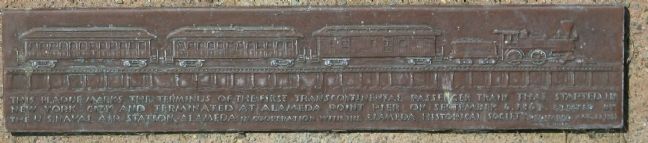
The 1st Transcontinental Railroad Main Marker
| 1 ► California, Alameda County, Alameda — 440 — Alameda Terminus of the 1st Transcontinental Railroad — |
| On West Mall Square, on the right when traveling north. | |||
| 2 ► California, Alameda County, Alameda — 968 — Pan Am China Clipper — |
| On West Mall Square. | |||
| 3 ► California, Alameda County, Alameda — 1029 — The Jimmy Doolittle Pier – Alameda Naval Air Station — Pier No. 3 — USS Hornet — |
| Near Hornet Avenue at Ferry Point. | |||
| 4 ► California, Alameda County, Alameda, West Alameda — 440 — First Transcontinental Railroad — Alameda Terminal — |
| On Lincoln Avenue at Webster Street, on the right when traveling west on Lincoln Avenue. | |||
| 5 ► California, Alameda County, Berkeley — 986 — Piedmont Way — |
| On Piedmont Way at Bancroft Way, in the median on Piedmont Way. | |||
| 6 ► California, Alameda County, Berkeley, Southside — 908 — Berkeley City Club — |
| On Durant Avenue near Ellsworth Street, on the right when traveling west. | |||
| 7 ► California, Alameda County, Berkeley, University of California, Berkeley — 946 — University of California Berkeley Campus — |
| Near South Hall Road north of Campanile Way, on the right when traveling south. | |||
| 8 ► California, Alameda County, Castro Valley — 776 — Site of First Public School in Castro Valley — |
| On Redwood Road near James Avenue, on the right when traveling north. | |||
| 9 ► California, Alameda County, Emeryville — 335 — Shell Mound Park — |
| Near Horton Street. | |||
| 10 ► California, Alameda County, Fremont, Mission San Jose — 334 — Mission San José — |
| On Mission Boulevard at Washington Boulevard, on the right when traveling north on Mission Boulevard. | |||
| 11 ► California, Alameda County, Fremont, Niles — 46 — Vallejo Flour Mill — ← ½ Mile — |
| On Mission Boulevard (California Route 238) 0.5 miles west of Niles Canyon Road, on the left when traveling west. | |||
| 12 ► California, Alameda County, Fremont, Vineyards - Avalon — 642 — Leland Stanford Winery — |
| On Stanford Avenue near Vineyard Avenue, on the left when traveling east. | |||
| 13 ► California, Alameda County, Hayward — 1025 — Honcharenko’s Sanctuary — |
| Near Garin Avenue. | |||
| 14 ► California, Alameda County, Hayward — 1025 — Ukrania — |
| 15 ► California, Alameda County, Livermore — 641 — Concannon Vineyard — |
| Near Tesla Road. | |||
| 16 ► California, Alameda County, Livermore — 586 — Cresta Blanca Winery — |
| Near Arroyo Road. | |||
| 17 ► California, Alameda County, Livermore — 241 — Robert Livermore — First Settler of Livermore Valley — |
| On Portola Avenue, on the right when traveling east. | |||
| 18 ► California, Alameda County, Livermore — 957 — Wente Bros. Winery — |
| Near Tesla Road. | |||
| 19 ► California, Alameda County, Oakland — 970 — Rainbow Trout Species Identified — |
| Near Redwood Road, 0.1 miles north of Redwood Gate, on the left when traveling north. | |||
| 20 ► California, Alameda County, Oakland — 962 — Site of Blossom Rock Navigation Trees — |
| Near Skyline Boulevard, 0.5 miles north of Joaquin Miller Road. | |||
| 21 ► California, Alameda County, Oakland, Downtown Oakland — 896 — First Unitarian Church of Oakland — |
| On Fourteenth Street at Castro Street, on the left on Fourteenth Street. | |||
| 22 ► California, Alameda County, Oakland, Downtown Oakland — 884 — Paramount Theatre — |
| On Broadway at 21st Street, on the left on Broadway. | |||
| 23 ► California, Alameda County, Oakland, Downtown Oakland — 45 — Site of College of California — Original Campus of University of California — |
| On Franklin Street at 14th Street, on the right when traveling north on Franklin Street. | |||
| 24 ► California, Alameda County, Oakland, Downtown Oakland — 1027 — The Pardee House — |
| On 11th Street near Castro Street when traveling west. | |||
| 25 ► California, Alameda County, Oakland, East Lake — 694 — Church of St. James the Apostle |
| On 12th Avenue at Foothill Boulevard, on the left when traveling south on 12th Avenue. Reported missing. | |||
| 26 ► California, Alameda County, Oakland, Joaquin Miller Park — 107 — Joaquin Miller — "Poet of the Sierras” — |
| Near Joaquin Miller Road at Sanborn Road, on the left when traveling east. | |||
| 27 ► California, Alameda County, Oakland, Oakland Ave - Harrison St — 676 — Site of Saint Mary's College — |
| On Broadway Avenue at Hawthorne Avenue, on the right when traveling south on Broadway Avenue. | |||
| 28 ► California, Alameda County, Oakland, Peralta Hacienda — 925 — Peralta Hacienda — Begun in 1821 — Fruitvale History Tour Site — |
| Near 34th Avenue near Hyde Street. | |||
| 29 ► California, Alameda County, Oakland, Piedmont Avenue — 299 — El Camino Rancho San Antonio — |
| On West MacArthur Boulevard at Broadway, on the right when traveling east on West MacArthur Boulevard. | |||
| 30 ► California, Alameda County, Pleasanton — 510 — Alviso Adobe — Alviso Adobe Community Park — |
| Near Old Foothill Road near Foothill Road. | |||
| 31 ► California, Alameda County, San Leandro, Farrelly Pond District — 285 — Peralta House — |
| Near Lafayette Avenue near Leo Avenue, on the right when traveling south. | |||
| 32 ► California, Alameda County, San Leandro, Farrelly Pond District — 246 — Rancho San Antonio — |
| Near East 14th Street (California Route 185) near Toler Avenue, on the right when traveling south. | |||
| 33 ► California, Alameda County, San Leandro, Mulford Gardens — 824 — San Leandro Oyster Beds |
| On North Pike Road near Neptune Road. Reported missing. | |||
| 34 ► California, Alameda County, San Leandro, Old San Leandro — 279 — Estudillo Home — |
| On West Estudillo Avenue near San Leandro Boulevard, on the right when traveling west. | |||
| 35 ► California, Alameda County, Union City — 503 — First County Courthouse — |
| On Union City Boulevard near Cambridge Way, on the right when traveling west. | |||
| 36 ► California, Alameda County, Union City — 768 — Site of the Nation’s First Successful Beet Sugar Factory — |
| On Dyer Street at Ratekin Drive, on the right when traveling west on Dyer Street. | |||
| 37 ► California, Alpine County, Kirkwood — 40 — Kirkwood's — |
| Near Carson Pass Scenic Byway (State Highway 88). | |||
| 38 ► California, Alpine County, Kirkwood — 315 — Kit Carson — |
| Near Carson Pass Scenic Byway (State Highway 88), on the right. | |||
| 39 ► California, Alpine County, Kirkwood — 378 — Memorial to Pioneer Odd Fellows — |
| Near Carson Pass Scenic Byway (State Highway 88). | |||
| 40 ► California, Alpine County, Kirkwood — 661 — Old Emigrant Road |
| On Carson Pass Scenic Byway (State Highway 88), on the right when traveling east. Reported missing. | |||
| 41 ► California, Alpine County, Kirkwood — 662 — Old Emigrant Road — |
| On Carson Pass Highway (California Route 88) at Mud Flat Road, on the right when traveling east on Carson Pass Highway. | |||
| 42 ► California, Alpine County, Markleeville — 318 — Ebbetts Pass — Historical Landmark — |
| On Ebbetts Pass Scenic Byway (State Highway 4), on the left when traveling east. | |||
| 43 ► California, Alpine County, Markleeville — 240 — Jacob Markley — |
| Near Alpine State Highway (California Route 89) south of Water Street, on the left when traveling south. | |||
| 44 ► California, Alpine County, Woodfords — 805 — The Pony Express - Woodfords — |
| On Old Pony Express Way (California Route 88) east of California Route 89, on the right when traveling east. | |||
| 45 ► California, Alpine County, Woodfords — 805 — Woodfords Station — |
| On Old Pony Express Way (California Route 88) east of California Route 89, on the left when traveling east. | |||
| 46 ► California, Amador County, Drytown — 31 — Drytown — |
| On Hanford Street (State Highway 49), on the right when traveling south. | |||
| 47 ► California, Amador County, Fiddletown — 35 — Fiddletown — |
| On Fiddletown Road, on the right when traveling east. | |||
| 48 ► California, Amador County, Fiddletown — 35 — Fiddletown-Oleta — |
| On Fiddletown Road, on the left when traveling east. | |||
| 49 ► California, Amador County, Ione — 788 — Daniel Stewart Co. Store — |
| On East Main Street, on the right when traveling west. | |||
| 50 ► California, Amador County, Ione — 30 — Lancha Plana — (No. 30 California Historical Landmark) — |
| Near Camanche Road. | |||
| 51 ► California, Amador County, Ione — 506 — Methodist Episcopal Church — |
| On West Marlette Street at South Sacramento St, on the left when traveling south on West Marlette Street. | |||
| 52 ► California, Amador County, Ione — 867 — Preston Castle — |
| On Highway 104, on the right when traveling east. | |||
| 53 ► California, Amador County, Jackson — 786 — Argonaut and Kennedy Mines — |
| Near State Highway 49. | |||
| 54 ► California, Amador County, Jackson — 39 — Butte Store — |
| On State Highway 49 at milepost 1.4,, 2.5 miles south of State Route 88, on the left when traveling south. | |||
| 55 ► California, Amador County, Jackson — 34 — Pioneer Hall — |
| On Main Street near Court Street, on the right when traveling south. | |||
| 56 ► California, Amador County, Jackson — 865 — Site of Pioneer Jewish Synagogue — |
| On Church Street at North Street, on the right when traveling north on Church Street. | |||
| 57 ► California, Amador County, Kirkwood — 28 — Maiden's Grave — |
| On Carson Pass Scenic Byway (State Highway 88), on the right when traveling east. | |||
| 58 ► California, Amador County, Pine Grove — 37 — Clinton — |
| On Clinton Road at Ponderosa Road / East Clinton Road, on the left when traveling south on Clinton Road. | |||
| 59 ► California, Amador County, Pine Grove — 38 — Pine Grove — |
| On State Highway 88 east of Irishtown Road, on the right when traveling east. | |||
| 60 ► California, Amador County, Plymouth — 762 — D'Agostini Winery — |
| On Plymouth - Shenandoah Road, on the right when traveling north. | |||
| 61 ► California, Amador County, Sutter Creek — 322 — General John A. Sutter — Sutter Creek — |
| On Main Street (State Highway 49), on the right when traveling north. | |||
| 62 ► California, Amador County, Sutter Creek — 1007 — Knight Foundry — |
| On Eureka Street, on the left when traveling east. | |||
| 63 ► California, Amador County, Volcano — 715 — Astronomical Observatory — |
| On Consolation Street at Main Street, on the right when traveling north on Consolation Street. | |||
| 64 ► California, Amador County, Volcano — 715 — Astronomical Observatory — |
| On Shake Ridge Road, 1 mile west of Rams Horn Grade, on the left when traveling west. | |||
| 65 ► California, Amador County, Volcano — 1001 — Chaw Sé Roundhouse — |
| Near Pine Grove Volcano Road. | |||
| 66 ► California, Amador County, Volcano — 29 — Volcano — |
| On Main Street at Consolation Street, on the right when traveling north on Main Street. | |||
| 67 ► California, Butte County, Chico — 840-2 — Chico Forestry Station and Nursery — |
| Near South Park Drive. | |||
| 68 ► California, Butte County, Chico — 313 — Hooker Oak — |
| On Manzanita Avenue east of Hooker Oak Avenue. | |||
| 69 ► California, Butte County, Chico — 329 — Rancho Del Arroyo Chico — |
| Near Esplanade near Memorial Way. | |||
| 70 ► California, Butte County, Magalia — 771 — The Dogtown Nugget — |
| On Old Skyway Road, 0.3 miles north of Pentz-Magalia Road, on the right when traveling east. | |||
| 71 ► California, Butte County, Oroville — 330 — Bidwell's Bar — 1853 – 1856 — |
| On Bidwell Canyon Road. | |||
| 72 ► California, Butte County, Oroville — 770 — Chinese Temple — |
| On Broderick Street, on the right when traveling east. | |||
| 73 ► California, Butte County, Oroville — 1043 — Mother Orange Tree of Butte County — |
| Near Glenn Drive south of Meadowview Drive, on the right when traveling south. | |||
| 74 ► California, Butte County, Oroville — 807 — Oregon City — |
| On Oregon Gulch Road at Oregon City Trail, on the left when traveling south on Oregon Gulch Road. | |||
| 75 ► California, Butte County, Oroville — 809 — The Last Yahi Indian — |
| On Oroville-Quincy Highway at Oak Avenue, on the left when traveling east on Oroville-Quincy Highway. | |||
| 76 ► California, Butte County, Oroville — 314 — The Mother Orange Tree of Butte County — Bidwell Bar Bridge — |
| On Bidwell Canyon Road. | |||
| 77 ► California, Calaveras County, Altaville — 288 — Altaville Foundry & Machine Works — Founded by J.M. Wooster — Est. 1854 — |
| Near State Highway 49. | |||
| 78 ► California, Calaveras County, Altaville — 499 — Altaville Grammar School — |
| Near Main Street (State Highway 49). | |||
| 79 ► California, Calaveras County, Altaville — 735 — Prince-Garibardi Building — |
| On South Main Street (State Highway 49) near Demarest Street, on the right when traveling south. | |||
| 80 ► California, Calaveras County, Angels Camp — 287 — Angels Camp — Home of the Jumping Frog — Romance - Gold - History — |
| On Main Street (State Highway 49) at State Highway 4, on the right when traveling south on Main Street. | |||
| 81 ► California, Calaveras County, Angels Camp — 734 — Angels Hotel — |
| On Main Street at Bird Way, on the left when traveling south on Main Street. | |||
| 82 ► California, Calaveras County, Angels Camp — 769 — Archie Stevenot — “Mr. Mother Lode” — |
| On Route 49, 3.7 miles south of California Highway 4, on the left when traveling south. | |||
| 83 ► California, Calaveras County, Angels Camp — 274 — Carson Hill — |
| On State Highway 49, 3.7 miles south of State Highway 4, on the left when traveling south. | |||
| 84 ► California, Calaveras County, Angels Camp — 276 — Robinson's Ferry — |
| On State Highway 49, on the left when traveling south. | |||
| 85 ► California, Calaveras County, Burson — 254 — Camanche — |
| Near Camanche Parkway South. | |||
| 86 ► California, Calaveras County, Calaveritas — 255 — Calaveritas — |
| On Calaveritas Road at Costa Road, on the right when traveling east on Calaveritas Road. | |||
| 87 ► California, Calaveras County, Campo Seco — 257 — Campo Seco — |
| On Campo Seco Road, on the left when traveling east. | |||
| 88 ► California, Calaveras County, Cave City — 956 — California Caverns at Cave City — California Historical Landmark No. 956 — |
| On Cave City Rdoad, 2 miles east of Michel Road, on the left when traveling east. | |||
| 89 ► California, Calaveras County, Copperopolis — 296 — Copperopolis — State Registered Landmark No.296 — |
| On Main Street, on the left when traveling south. | |||
| 90 ► California, Calaveras County, Copperopolis — 296 — Copperopolis — The Town of — |
| On Main Street, on the right when traveling south. | |||
| 91 ► California, Calaveras County, Copperopolis — 281 — O'Byrne Ferry — |
| On O'Byrne Ferry Road (State Highway 49), on the right when traveling south. | |||
| 92 ► California, Calaveras County, Douglas Flat — 272 — The Italian Store — |
| On Main Street, on the left when traveling east. | |||
| 93 ► California, Calaveras County, Jenny Lind — 266 — Jenny Lind — |
| On Milton Road, on the right when traveling east. | |||
| 94 ► California, Calaveras County, Milton — 262 — Milton Masonic Hall — |
| On Flint Street at Milton Road, on the right when traveling north on Flint Street. | |||
| 95 ► California, Calaveras County, Mokelumne Hill — 663 — Calaveras County Courthouse and Leger Hotel — |
| On Main Street at Lafayette Street, on the right when traveling north on Main Street. | |||
| 96 ► California, Calaveras County, Mokelumne Hill — 265 — Chili Gulch — |
| On State Highway 49, on the right when traveling north. | |||
| 97 ► California, Calaveras County, Mokelumne Hill — 269 — Mokelumne Hill — |
| On Main Street at Center Street, on the left when traveling south on Main Street. | |||
| 98 ► California, Calaveras County, Mountain Ranch — 282 — El Dorado — |
| On Whiskey Slide Road at Mountain Ranch Road on Whiskey Slide Road. | |||
| 99 ► California, Calaveras County, Murphys — 275 — Murphys — |
| On Main Street at Jones Street on Main Street. | |||
| 100 ► California, Calaveras County, Murphys — 267 — Murphys Hotel — |
| On Main Street at Algiers Street on Main Street. | |||
1050 entries matched your criteria. The first 100 are listed above. Next 100 ⊳