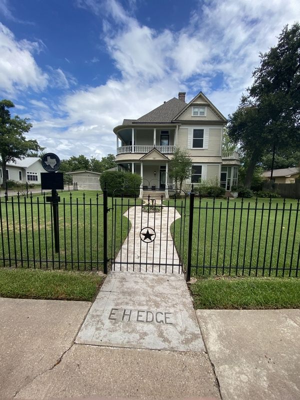
This Queen Anne style residence features a two-story wraparound porch with a decorative balustrade. The front porch, with its Doric columns and triangular pediment over the entryway, exhibits elements of the Colonial Revival style of architecture. . . . — — Map (db m255968) HM
At the polls on Oct. 29, 1877, the City of Bryan voted to establish a free public graded school--a very progressive step in an era of private schools. Interested citizens immediately bought and donated this block for the site. Financial help came . . . — — Map (db m255969) HM
Richardson Perry
Born in Mississippi — 1817
Died at the Alamo — 1836
On October 10, 1835, Perry received this league of land (4428 acres) as one of the Austin Colonists. This was one of the final Mexican land grants approved at San Felipe. The . . . — — Map (db m220452) HM WM
Bryan was first platted as a town in 1860 and was formally incorporated as the city of Bryan in 1871. The First Christian Church was organized in Bryan in 1866 and early meetings were held in local businesses and private homes. Colonel J.S. Proctor . . . — — Map (db m255970) HM
The State of Texas granted a charter for an independent school district to encompass the Texas A&M College campus in 1909. Because there was not a sufficient number of students in the district to support a school, A&M president William Bizzell and . . . — — Map (db m170201) HM
The Academic Building (1914) was designed by campus architect Frederick E. Giesecke, '86 and Samuel E. Gideon, after Old Main was destroyed by fire in 1912. The beaux-arts classical design is a four-storied reinforced concrete structure faced with . . . — — Map (db m120269) HM
Formal education for African Americans in Brazos County began as a result of the Public School Act of 1871. Classes were held in many small community and church-related schools, and by 1923 there were 127 African American students in the A&M . . . — — Map (db m170204) HM
On 2 March 1919, 53 Aggies were commemorated for their gallantry and their faithful service to their country during World War I. The ceremony was “a tribute to the sons of the college who fell in the World War for the cause of political liberty and . . . — — Map (db m285736) HM WM
Built in 1912, Bolton Hall was originally the Mechanical and Electrical Engineering Building. It was designed to mirror Nagle Hall, and with Old Main (burned 1912) formed the heart of old A&M's academic quadrangle. Considered "fire proof" due to its . . . — — Map (db m285728) HM
The Chemistry Building (1929) was designed by S. C. P. Vosper, using classical design proportions and details. It was extended to the east in 1981 and 1988. The ornamentation uses a variety of color schemes in tile patterns inspired from the art of . . . — — Map (db m120273) HM
In 1946, more than 30 acres were purchased from a local farmer to establish a municipal cemetery for the City of College Station. The property surrounded two previously established cemeteries: Shiloh Cemetery (also known as Rector Chapel Cemetery) . . . — — Map (db m260525) HM
In 1871 Texas Governor Edmund Davis appointed three Commissioners to select a site for the newly established Agricultural and Mechanical College of Texas (Texas A&M College). The Commissioners chose this location in large part because of the . . . — — Map (db m119630) HM
Pioneer Communities in Brazos County were aptly called neighborhoods or settlements. Settlements usually include a church, a school, and perhaps a crude cotton gin but often little else. This memorial is located on what is left of a two acre site . . . — — Map (db m283318) HM
Brazos County and the Brazos River
The 840-mile Brazos is the longest river entirely within Texas. The Brazos carries more water into the Gulf of Mexico than any other such river. The Brazos and the Navasota Rivers determine the physical . . . — — Map (db m283321) HM
The Brazos Valley was first settled and formed by people from all over America and other foreign lands. The earliest Anglo settlers arrived in this Mexican province from nearby southern states, lured by large Mexican land grants. After the Texas . . . — — Map (db m283311) HM
In 1920, David J. Finn and other Texas A&M electrical engineering students attempted to broadcast the football game at Oklahoma A&M via ham radio. When the plan failed they used a telephone backup, relaying game updates to fans gathered in the . . . — — Map (db m119624) HM
When Texas A&M University opened in 1876, it was four miles from Bryan, the nearest town, and the need for campus housing for faculty and staff arose. The first of the campus houses, five brick homes along the east side of Throckmorton Street, were . . . — — Map (db m119625) HM
Rolland Adelsperger, College Architect and Professor of Architecture and Architectural Engineering designed Francis Hall in a highly distinctive romanesque style in 1913 for the
School of Veterinary Medicine. The proposed design exceeded the . . . — — Map (db m120274) HM
Nothing since the attack on Pearl Harbor has had a greater impact on our great nation and its people than the terrorist attacks of 9/11. Aggies responded to this crisis in a magnificent way — volunteering to protect our cherished freedom and to . . . — — Map (db m238744) WM
Hart Hall was erected on the site of the old Assembly Hall razed in 1929. Named for Laurence J. Hart, a member of the Board of Directors (1909 - 1924). Designed as an experiment in student living known as the "ramp system" where rooms are accessed . . . — — Map (db m285730) HM
Harvey Mitchell Hall, erected in 1912 and razed in 1972, was named for the Father of Brazos County. He was responsible for locating the A. & M. College of Texas in Brazos County. This original cornerstone was placed, leveled and dedicated through . . . — — Map (db m285727) HM
The History Building was erected in 1922 as the Agriculture Building and housed the Dean of Agriculture for about ten years. Architect E. B. La Roche used a classical revival style with a strong base, rusticated brick main floor, and two-story . . . — — Map (db m120275) HM
In memory of
James Earl Rudder, 1910 - 1970
Class of 1932
Heroic Soldier
Commissioner of the General Land Office of Texas —
Sixteenth President of Texas A&M University -
Third President of the Texas A&M University System
Earl . . . — — Map (db m285732) HM
Heroic Soldier and World War II Military Leader
Commissioner of the General Land Office of Texas
Sixteenth President of Texas A&M University
Third President of the Texas A&M University System
At a critical juncture in the history of Texas . . . — — Map (db m285731) HM
Built in 1911, Legett Hall is the oldest residence hall on campus and one of two remaining along Military Walk. Named for Judge Kirvin Kade Legett (1857-1926) of Abilene, President of the Agricultural and Mechanical College of Texas Board of . . . — — Map (db m120270) HM
Texas A&M University opened in October 1876 and established the Corps of Cadets to fulfill its Congressional mandate to teach military tactics. The students at what was then an all-male institution were required to serve in the corps and follow . . . — — Map (db m119627) HM
Nagle Hall is one of the oldest buildings on campus, constructed in 1909 as the Civil Engineering building. Renamed in 1929 for James C. Nagle, the first dean of the School of Engineering. The design maintains the campus' distinct classical . . . — — Map (db m120268) HM
In 1831, Richard Carter (1789-1863), Virginia native and War of 1812 veteran, came from Alabama and received a grant of land within the Stephen F. Austin colony at the site of what is now the City of College Station. He became one of the areas . . . — — Map (db m168426) HM
German immigrant Adam Royder (d. 1894) donated one acre of land here for school purposes in 1891. A one-room schoolhouse was constructed where area students received instruction through the seventh grade. The Rock Prairie Missionary Baptist Church . . . — — Map (db m168058) HM
Sbisa Dining Hall (1913) was designed by campus architect Frederick E. Giesecke to replace the castle-like 1897 mess hall that burned in 1911. It anchors the north end of Military Walk whose south terminus was Guion Assembly Hall (1918-1971). A . . . — — Map (db m120271) HM
Just four years after Juneteenth, Gaines won election to the Texas State Senate by a two-to-one margin over his closest contender; becoming one of two Black senators and twelve Black representatives seated in the 12th Texas Legislature in . . . — — Map (db m285734) HM
Settled in the 1860s by Czech, German, and Polish immigrants, the Shiloh community was an area of large family farms. In addition to homes and farms, the settlement at one time boasted a community center, a two-room school, a vineyard, a mill, and a . . . — — Map (db m102000) HM
Silver Taps, held the first Tuesday of every month is that final tribute paid to an Aggie who, at the time of his or her death, was enrolled at Texas A&M.
On the day of Silver Taps, the flag in front of the Academic building is flown at . . . — — Map (db m238302) HM
Soon after its opening in 1876, the Agricultural and Mechanical College of Texas (Texas A&M) established the Corps of Cadets to fulfill its mandate to instruct its students (all-male until the early 1960s) in military science. A&M contributed more . . . — — Map (db m119628) HM
The State Legislature authorized the Agricultural and Mechanical College of Texas April 17, 1871, under terms of the Federal Morrill Act. Constitutionally a part of a chartered, yet-unorganized state university, A&M gained its own directorate in . . . — — Map (db m119592) HM
World War I allowed the Agricultural and Mechanical College of Texas to expand beyond military training and directly contribute to the war effort with staff and students volunteering for service in large numbers. Students first served for other . . . — — Map (db m126521) HM
This memorial walkway was established in 1997 as a part of the master landscape plan of the College Station cemetery. It provides patrons an opportunity to honor loved ones while benefiting the cemetery endowment fund, which was created to insure . . . — — Map (db m170337) HM
On January 2, 1922, Texas A&M played Centre College in the Dixie Classic in Dallas. After numerous injuries to the Aggie team, Coach Dana C. Bible called E. King Gill '24 from the stands. Gill, a basketball player and former football team member, . . . — — Map (db m285733) HM
The Williams Building (1932) was designed by architect S. C. P. Vosper in a classical revival
style as the headquarters for the Texas A&M System. The building faced the new state highway symbolizing the shift from train to automobile travel. The . . . — — Map (db m120276) HM
In 1918–19, Texas A&M President W.B. Bizzell asked ministers of Bryan churches to provide religious services for students of their respective denominations. In response, Rev. P.T. Ramsey of First Methodist Church provided $500 and encouraged . . . — — Map (db m238739) HM
From 2005—2013, this turf was part of the end zone at Kyle Field—one of the most prized patches of grass in Aggieland. Over the course of that time, it played host to Aggie football greats like Von Miller, Jovorskie Lane, Red Bryant, Martellus . . . — — Map (db m220387) HM
Prior to the football game against TCU in 1930, A&M Regent, Pinky Downs (Class of 1906), shouted, “What are we going to do to those Horned Frogs?” Sticking with the theme of frog hunting, he said, “We’re going to ‘Gig’em, Aggies!” As he shouted, he . . . — — Map (db m250966) HM
This drill field is dedicated to all the former members of the Fightin’ Texas Aggie Band who marched here, rehearsed here, and with hard work and determination, learned the skills necessary to perform the flawless halftime drills that are the . . . — — Map (db m239308) HM
In 1917, while a student at the Agricultural and Mechanical College of Texas, James Vernon “Pinky” Wilson ’20 enlisted in the United States Marine Corps to join WWI. While Stationed in the foxholes and trenches of France, he composed the words . . . — — Map (db m221431) HM WM
1902 Model 3 Inch Field Artillery Piece
First fired on this site September 4th, 1982
Parsons Mounted Cavalry Cannoneers
Grant H. Gilson ’83 — Section Chief Robert J. Butrico, Jr. ’83 • Lee S. Netterville ’83 • Robert C. Drury ’84 • . . . — — Map (db m238805) HM
Born 24 March 1918
Son of Mr. & Mrs. James Newton Hollingsworth at Woodland Farm, Denton County, near Sanger, Texas
A&M College of Texas: BS-Agri-1940
United States Army 1940-1976 2nd Lt - Lt General
Command & General Staff College 1952 . . . — — Map (db m238847) HM WM
All Gave Some - Some Gave All
This memorial site is dedicated to honor and remember these fellow 11 classmates who made the supreme sacrifice while defending American ideals of freedom and democracy during the Vietnam War.
Rededicated . . . — — Map (db m307677) WM
In recognition of the splendid participation by the A. & M. College of Texas in the World War and of the heroic sacrifices made by her sons
This memorial is given by the Classes of 1923-24-25-26
Our Soldier Dead
E.C. Allison • . . . — — Map (db m238807) WM
Fish Donald Coward ’72, his CO John W. Groves ’69, and George W. Reynolds ’72 were killed in an auto accident when traveling to a Dallas Corps trip in the fall of 1968. Just three weeks prior, Donald had written a letter to his parents reflecting . . . — — Map (db m304344) HM
Zion Church is the oldest established congregation of its denomination in Brazos County. It was created in the 1890s by some thirteen families, most of German descent, on land donated by German immigrants in the community of Kurten. Zion Evangelical . . . — — Map (db m268124) HM
Millican was Texas' northernmost railroad terminus when the war between the states began in 1861. It became a vital Confederate shipping point for the area extending to the Red River on the north and to the frontier settlements in the west. The . . . — — Map (db m190131) HM
Old Three Hundred Colonist William T. Millican was born in South Carolina about 1780 and came to Texas with his parents and siblings in 1821. They joined Stephen F. Austin's first colony and were granted land in this area on which to make their . . . — — Map (db m179148) HM
Following Emancipation, Federal Union soldiers arrived in Millican, along with the Freedmen's Bureau, to assist in the transition to Reconstruction. At the same time, the Ku Klux Klan first appeared in Millican, parading through Black . . . — — Map (db m267494) HM
The town of Wellborn was founded in 1867 along the Houston and Texas Central railroad line. By 1874, with the first documented burial -- that of two-year-old Newton Farquhar -- a cemetery was in existence to serve the community. A reflection of . . . — — Map (db m170195) HM
San Salvador, a mission of St. Anthony's Catholic Church, Bryan, was named for the patron saint of Cefalu, Sicily, the native village of Italian immigrants who came here in 1894. Religious services were held in homes until 1908, when devout families . . . — — Map (db m187394) HM
During reconstruction, emancipated African Americans established rural settlements where they would be free to live, work and worship. Edmond Bell and his wife, Vina, and the families of their children, Simon, Henry, John, William M., Harriet and . . . — — Map (db m268113) HM
Also known as the Old Tunis Cemetery, this burial ground originally served a pioneer area of the fertile Brazos Valley. Graves date from the 1840s, and John and Sarah Wright Echols formally set aside land in 1867 for this graveyard and a Baptist . . . — — Map (db m220019) HM
Destructive Brazos River floods have often plagued residents of Burleson County. In 1899, a 30-inch rain killed 35 and caused about $9 million in property damage. Again in 1900, 1902 and 1908 Brazos River bottom inhabitants endured serious . . . — — Map (db m135747) HM
Farmed early as 1744 by Indians under guidance of Spanish missionaries. In 1830, Ft. Tenoxtitlan, guarding Brazos crossing, San Antonio Road, attracted Anglo-Texans, who lived off wild game in early years.
County created and organized in 1846. . . . — — Map (db m129339) HM
In rich Brazos River basin; had settlers early as 1825. Site in 1830 of Tenoxtitlan, one of 3 forts built by Mexico in Texas, situated above El Camino Real (The King's Highway) crossing on Brazos River. North of the road was Sterling Robertson's . . . — — Map (db m201845) HM
During World War II, out of a population of 18,000 close to 1300 men and women from Burleson County joined the military, with 450 who attended Caldwell High School drafted or voluntarily enlisted. Many had never been outside the county before their . . . — — Map (db m125665) HM
On Feb. 23, 1861, citizens voted for secession, 422 to 84. On March 1, the "Burleson Guards" organized and offered its services to the state. Most "Guards" were mustered into Co.G, 2nd Texas Infantry Regt., and others served in Walker's Texas . . . — — Map (db m125671) HM
With more than 2,700 burials, this cemetery is a significant reflection of the heritage of Caldwell and Burleson County. It began as a Masonic cemetery in 1890 when Warren Lodge No. 56 purchased land here for that purpose. There already were at . . . — — Map (db m210791) HM
On January 24, 1903, a group of local businessmen under the direction of J. J. Lane and C. C. Nelms met for the purpose of establishing a National Bank. The thirty original stock subscribers who attended pledged $25,000 in organizational capital and . . . — — Map (db m150939) HM
The Chisholm Trail, which was developed following the Civil War, allowed Texas cattle to be driven to railheads in Kansas for shipment to eastern markets. An arm of the celebrated route, reaching from Matagorda County to the main trail near present . . . — — Map (db m135746) HM
In 1840 the Republic of Texas Congress annexed to Milam County all of Washington County north of Yegua Creek and west of the Brazos River. The name Caldwell, which honored Mathew "Old Paint" Caldwell, a noted pioneer and a signer of the Texas . . . — — Map (db m125666) HM
Founded 1840 by Lewis L. Chiles, a veteran of Battle of San Jacinto. Named for Mathew "Old Paint" Caldwell, Indian fighter and signer of the Texas Declaration of Independence. This was county seat, Milam County, in 1845; since 1846 county seat of . . . — — Map (db m286766) HM
Founded about 1840 where colonial road from southeast crossed San Antonio Road.
Settler Gabriel Jackson had two-story log cabin-trading post here. Community was named for Silas L. Cooke, who surveyed much land in this vicinity. It is now a . . . — — Map (db m125653) HM
Rudolph and Anna Duewall established a family farm here in the 1880s upon moving to Burleson County. Their son Edward (1885-1944) and his wife, Lizzie (Herrmann) (1890-1947), continued the farm operations. In 1928, they built this house on the site . . . — — Map (db m210799) HM
When Mexican Dictator Santa Anna revoked national rights, 30 or more men from this sparsely settled area left to resist his armies: in Grass Fight (Nov. 26, 1835), Siege of Bexar (Dec. 5-9) and other actions. While able men were absent, the foe . . . — — Map (db m201851) HM
Given to Methodist church as a camp-meeting site, by the Isaac S. Addison family. Mrs. Addison named camp in honor of Bishop Beverly Waugh, who presided at first Methodist Conference in Texas, and who, like the Addisons, was from Baltimore, Md. Site . . . — — Map (db m267499) HM
First Methodist Church in the county. Began as Sunday School in home of Isaac Addison, early settler. Later moved to home of Mrs. Elizabeth Scott. Organized about 1839 by Robt. Alexander, famous pioneer minister. Soon a small, hand-hewn frame . . . — — Map (db m129340) HM
Originally named Dove Church. Organized May 4, 1843, in home of Laban Rice, one of six charter members. Noted frontier ministers R.E.B. Baylor and Noah Byars presided at founding, and Byars served as first pastor.
First building (1844) stood on . . . — — Map (db m204221) HM
This congregation was organized by the Rev. Hugh Wilson, an early Presbyterian missionary noted for his active work on the Texas frontier. Although the first account of the church appears in an 1850 document, it is likely that the congregation was . . . — — Map (db m204236) HM
Congregation, organized 1840, is one of the oldest in Texas. It was one of 12 appointments on Nashville Circuit, Galveston District, Republic of Texas. Early worship was in various temporary structures. Here, in 1841, the Republic gave this church a . . . — — Map (db m204225) HM
Founded by Mexico as a bulwark against Anglo-American immigration, this fort and its nearby city were twice proposed for the capital of Texas.
Alarmed by the influx of Anglo settlers into Texas, Mexico in 1830 sought to erect a line of forts to . . . — — Map (db m129343) HM
In 1854, numerous slaves arrived near Cooks Point, led by A.S. Broaddus on a six-month wagon ride from Virginia. In 1887, many now-emancipated African American families asked Broaddus to help establish their own church. After the purchase of land . . . — — Map (db m267495) HM
Born in Tennessee c. 1836-37, John Mitchell came to Texas in 1846. He began purchasing land in this area in 1870, the same year he married Viney Cox. As a member of both the 12th and 14th Legislatures, Mitchell championed increased educational . . . — — Map (db m125669) HM
Kings Highway - Camino Real - Old San Antonio Road.
Marked by The Daughters of The American Revolution and the State of Texas A.D. 1918 — — Map (db m222168) HM
Kings Highway Camino Real Old San Antonio Road
Marked by The Daughters of The American Revolution and The State of Texas A.D. 1918 — — Map (db m222390) HM
Kings Highway Camino Real Old San Antonio Road
Marked by The Daughters of The American Revolution and The State of Texas A.D. 1918 — — Map (db m222393) HM
Kings Highway Camino Real Old San Antonio Road
Marked by The Daughters of The American Revolution and The State of Texas A.D. 1918 — — Map (db m222396) HM
A San Jacinto Veteran; founder of the city of Caldwell. Born in Virginia in 1811; died May 29, 1864. His wife Emily Hitchcock Chiles; born December 13, 1824; died June 9, 1877 — — Map (db m286838) HM WM
Traveling ministers conducted services in this area during the 1840s. The church was organized about 1852 and located on land belonging to Ezra Webb. Oldest marked grave in the adjacent cemetery is that of Elder W. G. O'Bryan, who died in 1867. The . . . — — Map (db m267498) HM
This Flagpole is dedicated to the war veterans who are buried in the Masonic Cemetery. The Civil War, Spanish American War, World War I, World War II, Korean War and Vietnam. It is made possible through the combined efforts of the Caldwell Cemetery . . . — — Map (db m210795) WM
Situated where the Old San Antonio Road crossed the Brazos River, this public ferry was begun by Michael Boren (1806-75) about 1846. The ferry and a settlement nearby were named for Daniel Moseley (1787-1856), who took over the service in 1849 and . . . — — Map (db m68684) HM
Noted pioneer leader. Member Virginia House of Delegates (1844-45). Piloted to Texas (1854) a mile-long wagon train of 200 people, who built Salem Baptist Church - reminder of their Virginia home.
Broaddus debated the Hon. Sam Houston at . . . — — Map (db m125652) HM
Following the Civil War, African American communities established churches which became centerpieces of their culture, not only through spiritual guidance but also education, social activities and political empowerment and organization. In 1870, . . . — — Map (db m267497) HM
About 1870 this area of Burleson County was settled by Czech-Moravian immigrants in search of fertile land and the religious freedom denied them in their native European homeland. Informal services were held twice a year in the family home of Joseph . . . — — Map (db m220013) HM
New Tabor was settled by Czech and German immigrants in the 1870s and 1880s. It was named for the community of Tabor in Czechoslovakia. In February 1888, Henry Ginzel sold 3 1/4 acres of land for a cemetery to trustees F. Jurcak, G. Hnilica and J. . . . — — Map (db m220014) HM
Created in 1840 (same year Caldwell was laid out) when lots 3 and 12 were made a "Grave Yard and Church lot" forever.
Town founder Lewis L. Chiles (d.1864) is buried here. Oldest legible stone is for Margarette A. King and infant daughter . . . — — Map (db m201847) HM
According to oral tradition, this cemetery has served residents of the Providence area since the 1830s. The earliest marked grave is that of Elizabeth Hughes, who died in 1841, but the presence of unmarked graves suggests that the burial ground was . . . — — Map (db m220017) HM
During the 1880s, many African American communities in the area, such as Teal Prairie, Cedar Creek, and Six Mile, did not have formal schools. In 1894, Horace and Charles Smith decided to open a school near Rita called Smith Grade High School. . . . — — Map (db m267508) HM
Founded by freed African American men and women after the Civil War, St. Matthew Colored Baptist Church was organized in the 1870s-1880s under the leadership of the Reverend Riley Williams (1812-1912). The church supported the improvement of the . . . — — Map (db m267509) HM
Burleson County was established in 1846 with Caldwell as the county seat. By the late 1840s Caldwell had a population of about three hundred. Local Masons began organizing and in October 1848 nine Freemasons petitioned George M. Patrick, Grand . . . — — Map (db m204219) HM
A leader in Texas colonization, Alexander Thomson, Jr., was born in St. Matthew's Parish, South Carolina, the only son of Alexander and Lucy (Fontaine) Thomson. He later lived in Georgia before moving to Tennessee. There, in 1830, he became a . . . — — Map (db m210613) HM
Colonial statesman, Methodist lay leader, pioneer in Burleson County. Came to Texas in 1822 from Kentucky. Had office of surveyor, Austin's Colony, 1823 - 1836; was a military officer in Indian conflicts and also Army of Gen. Sam Houston during . . . — — Map (db m210617) HM
4174 entries matched your criteria. Entries 101 through 200 are listed above. ⊲ Previous 100 — Next 100 ⊳