313 entries match your criteria. Entries 101 through 200 are listed.⊲ Previous 100 — Next 100 ⊳
Windmills Historical Markers
Windmills have been used by humanity for more than a millennia to harness power for a variety of work. The series includes markers describing actual windmills and replica non-working windmills built for tourism, novelty, or other purposes. (It does not include markers that simply include the word Windmill in the text.)
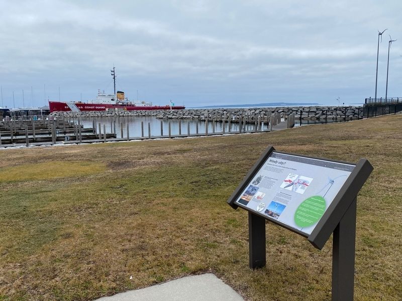
Mackinaw City is one of the windiest places in Michigan
Step aside, Chicago. Michigan is harnessing its wind to generate electricity in many locations throughout the state, including Mackinaw City. The eight wind turbines located at the east . . . — — Map (db m214019) HM
Once a common sight in rural America, the windmill was primarily used to pump water. The mechanical energy generated by the windmill was also used to run machines to chop cornstalks for fodder shell corn, or grind grain into flour. With the advent . . . — — Map (db m174995) HM
Near Marsh Road 0.3 miles north of Central Park Drive, on the left when traveling north.
The Farmstead
Meridian Township was primarily settled by German families. The Grettenbergers, Unruhs, Brays, and Proctors came to an area covered in forests and wetlands. The tree needed to be cut down in order to get seed in the ground. . . . — — Map (db m174993) HM
On West Michigan Avenue, on the left when traveling east.
On Sept. 24, 1898, Barney Toufel bought the lot on which John Askew's brick blacksmith shop stood. He then
tore it down and built the building called the Well Block. Known as the Well Block because of its adjacency to
the public well; the . . . — — Map (db m226827) HM
Near E. Gull Lake Drive north of E. B Avenue, on the left when traveling north.
W.K. Kellogg (1860-1951) founded the Toasted Corn Flake Company of Battle Creek in 1906. In 1925, Kellogg and his second wife, Dr. Carrie Staines, a physician at the Battle Creek Sanitarium, commissioned Benjamin and Benjamin of Grand Rapids to . . . — — Map (db m68818) HM
Near Franklin Road south of Club Drive, on the left when traveling south.
Notice the steel rods imbedded in the boulders in front of you. These boulders anchored a tall windmill that stood here during the 1800's farming days. The fourth rock anchor is located in front of the Visitor Center — — Map (db m202758) HM
Obverse
In 1961 Castle Park resort owner Carter P. Brown proposed the idea of creating a public park with an "authentic Dutch windmill," a symbol of Holland's Dutch heritage. To do so. the city officials needed permission from the . . . — — Map (db m154379) HM
This is an original piece of the old blades of our
windmill. The blades served De Zwaan from
the early 1900's through March of 2000.
This windmill was used as a lookout in the
Netherlands during World War II. If you look closely, you will be . . . — — Map (db m225662) HM
On South Main Street 0.2 miles north of West Ann Arbor Trail, on the right when traveling north.
Henry W. Baker (1833-1920) built this Italianate style house in 1875. Born in Richmond, New York, Baker had moved to this area while still a boy. As a young man, he worked as a photographer, a merchant and a lumberman. At the age of forty-nine, he . . . — — Map (db m33078) HM
The Seppman wind mill produced flour until it fell victim to natural disasters and new milling technology.
Construction Begins
Realizing the need for a local source of flour, Louis Seppman, a stone mason by trade, began . . . — — Map (db m197018) HM
On South State Street south of Center Street, on the left when traveling south.
On this site in 1859 Frederick Roebbecke built a seventy foot high wooden windmill for grinding corn and grain. Situated on a prominent ridge, it commanded an excellent view of the scattered settlement. Barricaded with sacks of flour and grain, the . . . — — Map (db m65400) HM
Near County Road 11 0.3 miles east of State Highway 371, on the left when traveling east.
The hillcrest where you are standing is 1,378 feet above sea level, 70 feet higher than County Road 11 at the entrance to the park. Add another 100 feet to the floor of the tower cab, and you get a commanding view of the area. This site was . . . — — Map (db m237500) HM
On N. Washington Avenue west of N. 3rd Avenue, on the right when traveling west.
With spacious showrooms along Washington Avenue and the Great Northern railroad tracks along the lower level, this building was in a prime location to showcase and ship out farm supplies that were in high demand during the westward expansion. . . . — — Map (db m249909) HM
Near McGinty Road E. at Plymouth Road, on the left when traveling west.
Minnetonka Mill flour sack.
Burwell Park is closely linked with one of the strongest traditions in Minnetonka's development—milling. The first visitors from Minneapolis in 1852 recognized the valuable lumber resources . . . — — Map (db m293371) HM
Near County Road 120 west of County Highway 33, on the left when traveling east.
What Is A Continental Divide?
A continental divide or watershed is a naturally occurring ridge on the continent that forces the separation of river systems. As rivers, streams and creeks separate, they are collected into many . . . — — Map (db m260558) HM
On Limit Avenue (U.S. 65) south of 16th Street, on the left when traveling north.
The Trail's End Project is an historical, educational and artistic tribute to the American spirit of opportunity, adventure and perseverance staged in the 1860's era of dynamic western development. The times were turbulent with political[,] . . . — — Map (db m85134) HM
On Orgain Avenue near Drake Street, on the right when traveling east.
Pierre Wibaux, scion of a distinguished French textile family, arrived here at the settlement of Mingusville in 1883, establishing a cattle ranch about 12 miles north. His herds fared well during the devastating “Hard Winter of 1886-1887,” after . . . — — Map (db m163387) HM
On State Highway 61 8.5 miles north of U.S. 34, on the right when traveling north.
In May 1944 German prisoners of war from Camp Atlanta, Nebraska, were sent to a side camp near here to help area farmers complete the 1943 corn harvest. Seven farmers employed forty-four Germans, who harvested some ten thousand bushels of corn. Six . . . — — Map (db m180995) HM
On West 3rd Street at A Avenue when traveling west on West 3rd Street.
Swedish immigrants began homesteading Mirage Township, Kearney County, in 1873. By 1876 these families had formed the Swedish Lutheran Church (Bethany Lutheran), the first church in Kearney County. The tempo of settlement increased with the coming . . . — — Map (db m251236) HM
Near North Buffalo Bill Avenue 0.8 miles north of Lincoln Highway (U.S. 30), on the right when traveling north.
You are standing in front of a typical scene found in most farmyards in Lincoln County. A windmill and cistern were vital to the survival of both humans and livestock, especially during the hot, dry Nebraska summers. The windmill allowed farmers and . . . — — Map (db m191774) HM
On Central Avenue east of North 15th Street, on the left when traveling east.
Built in 1902, this is the last intact historical windmill factory in the United States. Cousins Louis and George Kregel began windmill production in 1879 across the street. After moving here, the company (now owned by George Kregel) produced . . . — — Map (db m251358) HM
On Central Avenue at 15th Street, on the right when traveling east on Central Avenue.
The "ELI" windmill was the brand name of
windmills produced by the Kregel Windmill
Factory of Nebraska City, NE, as seen across
the street. Named after family friend &
business mentor, Reverend "ELI" Huber,
these windmills were durable, . . . — — Map (db m251362) HM
On Central Avenue east of 15th Street, on the left when traveling west. Reported permanently removed.
This "ELI" Windmill was the brand name of windmills produced by the Kregel Windmill Factory of Nebraska City. Established in 1879, by George F. Kregel, the factory produced windmills up until World War II. Due to materials rationing for the war . . . — — Map (db m66213) HM
Near Interstate 80 at milepost 381, 2 miles east of Exit 379 (State Highway 15), on the right when traveling east.
Most of Nebraska was once virgin grasslands. The first settlers often lived in crude sod huts, known as "soddies," and many worked for years transforming the prairie into producing cropland. Water was often scarce, especially in the drier climate . . . — — Map (db m265998) HM
On Market Street, on the right when traveling west.
Born in 1798 into a family of Portsmouth Mariners, John Samuel Blunt was apprenticed in the Boston workshop of artist John Ritto Penniman where, from age 14 to 21, he mastered the art of ornamentation. Here, he met other ambitious young artists who . . . — — Map (db m97040) HM
On Riverside just north of Absecon Boulevard (U.S. 30), on the left when traveling north.
Wind Farm
A joint project by Community Energy Inc. (CEI), and ACUA, the Jersey-Atlantic Wind Farm resulted in a wind-generation facility sized to meet the electrical load requirements of the ACUA Wastewater Treatment Facility with . . . — — Map (db m190963) HM
On Haworth Avenue at Owatonna Street, on the left when traveling west on Haworth Avenue.
In 1895, the Haworth Water and Light Company purchased land and drilled an artesian well at Owantonna St., 400 feet north of Haworth Avenue. A windmill pumped the water uphill to a 50 foot high storage tank built on the median of Haworth Avenue at . . . — — Map (db m252661) HM
On Stafford Avenue just west of Division Street, on the left when traveling west.
This private home is a Queen Ann Victorian style house built in 1898, at a cost of $5,000. The home features fish scale shingles, stained glass windows, a two story turret with witches hat roof, gingerbread trim, two inside stairways, a personal . . . — — Map (db m209209) HM
On City of Rocks (Park Road) 1.8 miles north of State Highway 61.
Since ancient times, Man has harnessed the power of the wind. The earliest known use of wind power is the sailboat, and this technology played an important role in the development of sail-type windmills. Windmills have been around for at least . . . — — Map (db m157899) HM
On Fuhrmann Boulevard at North Gates Avenue, on the left when traveling north on Fuhrmann Boulevard.
In June 2007, eight wind turbines began operation along the shores of Lake Erie, capturing the constant breezes and generating enough clean energy to power 6,000 homes. The "Steel Winds" project is unique for several reasons, most notably its . . . — — Map (db m93997) HM
Near Amvets Drive at Porter Avenue, on the right when traveling south.
Waterfront Sites From the LaSalle Park Gateway From the miltary garrison in Fort Erie to the wind turbines visible to the south, this vantagepoint depicts the endeavors of over 250 years of economic history. LaSalle Park. Named for the . . . — — Map (db m93008) HM
On South Buffalo Street (New York State Route 240) 0.1 miles south of East Quaker Street (U.S. 20A), on the left when traveling south.
Ambrose C. Johnson (1823-1894) and his wife Mary Abbey (1826-1901) of Hamburg came to Orchard Park about 1855. In 1858 Ambrose began a partnership with Charles Hewson, founding Johnson & Hewson's Dry Goods. The store, located immediately north on . . . — — Map (db m80749) HM
On Bridge Road (New York State Route 185) at Adirondack Park Road, on the left when traveling north on Bridge Road.
Crown Point is the site of two major 18th-century fortifications: France's Fort St. Frédéric and Great Britain's fort at Crown Point. The ruins of these forts have survived substantially unchanged since the late 18th century and have been . . . — — Map (db m162026) HM
Near Sagamore Hill Road, on the right when traveling north.
The windmill to your left is a re-creation of two previous windmills Theodore Roosevelt had built. The first was constructed when the house was built. A second windmill, and a supplemental gas-powered pump, replaced that one in 1905. The mills . . . — — Map (db m90398) HM
Near Sagamore Hill Road, on the right when traveling north.
In its many area devoted to different activities, this estate reflected the energy and diverse interest of its owner. A series of markers identifies each of the buildings or features of the estate explaining their use. — — Map (db m43056) HM
Near Sagamore Hill Road, on the right when traveling north.
Sagamore Hill was the family home of our 26th President Theodore Roosevelt, his wife Edith and their six children. He built the Queen Anne Shingle style home on 155 acres between 1884 and 1886 and it became known as the “Summer White House” during . . . — — Map (db m42840) HM
Near Sagamore Hill Road, on the right when traveling north.
Water was pumped for the house by wind power. The windmill structure also offered a challenge to small gymnasts in the family who loved to clamber about it. — — Map (db m42976) HM
On East 11th Street west of Avenue B, on the right when traveling west.
At this site, a group of Lower East Side residents created one of the first sweat equity rehabilitation projects and pioneered solar and wind energy installations in New York City. They installed the first wind turbine in New York on the roof of . . . — — Map (db m273368) HM
Near Lafayette Street near Duane Street, on the left when traveling south.
Foley Square c. 1800 consists of a central medallion surrounded by four segments of three medallions.
Central medallion: Map of Foley Square c. 1800
Around the perimeter: We hold these truths to be self-evident, that all men are created . . . — — Map (db m128579) HM
On Broadway at Barclay Street, on the left when traveling south on Broadway. Reported permanently removed.
INTRODUCTION In September 1609, Henry Hudson and some 20 seamen sailed their ship, the Halve Maen (Half Moon), into what is today New York harbor. The Dutch East India Company expected Hudson to find a passage to Asia. Instead, his . . . — — Map (db m127518) HM
Near State Street at Whitehall Street, on the right when traveling east.
Under Peter Minuit, the settlers of the little city of New Amsterdam worked quickly. By about 1627 they had 30 wooden houses constructed along “The Strand”, facing the bluffed shore 500 yards across the water of what would soon be named . . . — — Map (db m310040) HM
Near Barry Road, on the left when traveling north.
The Dutch East India Company commissioned Henry Hudson to identify a northwest passage to the Indies. As a part of that effort, Hudson entered New York Bay on September 11, 1609 in his vessel The Half Moon and sailed up the river that now bears his . . . — — Map (db m47130) HM
Top Left This is an undated picture from the collection of the Theuner family. They owned the property for a short time in the 1920's. Note the porch lanterns, probably fueled by acetylene. This was the first house in town to have working . . . — — Map (db m134007) HM
Near Middle Line Road (County Route 59) west of Saratoga Road ( Route 50).
On the ground here are the remains of the windmill (pictured) that, in the early 1900s, provided the power to pump water from the man-made pond on your left to the house which stood behind you. Because of this system, the house was the first one in . . . — — Map (db m284370) HM
On Morris Street at Ann Street, on the right when traveling west on Morris Street.
Stone Wind Mill Built 1825 at Morristown, New York by Hugh Mc Connell a miller from Scotland [stone at base of marker] This windmill property given to the village of Morristown, July 24, 1943, by Laura S. Chapman and Charles S. Chapman, N.A., . . . — — Map (db m88803) HM
Even though the Patriots only numbered about 180 in the windmill, Ogdensburg was home to a host of sympathizers, many of whom were prevented by the American infantry from joining or supplying their comrades. But many of the most vocal and active . . . — — Map (db m75729) HM
On Wharf Street at Ferry Road, on the right when traveling south on Wharf Street.
(Lower panel:)
Erected by the citizens of Sag Harbor in the year Nineteen Hundred and Sixty Six as an historic memorial to the great whaling industry which is part of our heritage. The original windmill was constructed in 1760 and stood 50 . . . — — Map (db m133842) HM
On Sagg Main Street 0.1 miles south of Montauk Highway, on the right when traveling south.
Site of a spider legged mill.
Subject of a famous lawsuit
which decided the rights of
landowners to adjacent highway
New York State law, 1842.
— — Map (db m111012) HM
Near Broadway Ave. north of Montauk Hwy, on the right when traveling south.
This windmill was used for pumping ground water on the Powell Estate in Sayville, L.I., N.Y. It was located at the foot of Handsome & Greene Aves on the Great South Bay. It was moved by Arthur O’Dell in 1914 to his farm on the west side of Johnson . . . — — Map (db m123421) HM
On Ridge Road-Main Street (County Route 103) at Lake Avenue ( Route 21), on the left when traveling west on Ridge Road-Main Street.
Mural scene descriptions:
- As a representation of Williamson’s Dutch heritage the Windmill Vacation Cabins in East Williamson had a replica of a working windmill as its center of attraction. Circa 1960’s
- Early 1900’s Main Street . . . — — Map (db m274741) HM
Near Central Street at Fairway Avenue, on the right when traveling south.
In 1884 the "Chester and Lenoir Narrow Gauge Railroad" arrived in Caldwell County and the small, sawmill community of Hudson. The advent of the railroad forever changed the town and its people. A depot was soon built, and the arrival of the daily . . . — — Map (db m254787) HM
Near U.S. 64 at Buzzy Lane, on the left when traveling north.
“Everything on the Banks seems to be devoid of paint – dwellings, barns and windmills, of which there are a greater number than I supposed were in existence in the whole country.”
Charles Johnson, Hawkins Zouaves, 1862
Roanoke Island, and . . . — — Map (db m190958) HM
In the 1800s Ocracoke had several working windmills. This stone came from the mill located near the entrance to Silver Lake, a area still known today as Windmill Point.
Donated by Paul and Irene Mosher. — — Map (db m212863) HM
On Goldsboro Street South west of South Street South, on the right when traveling west.
Vollis Simpson's farm, located eleven miles outside of Wilson in the community of Lucama, became one of Wilson County's top tourist destinations without the benefit of any advertising. In the 1980s, locals referred to the area as "Acid Park" . . . — — Map (db m290841) HM
On Goldsboro Street South (North Carolina Route 1163) at Kenan Street Southwest, on the left when traveling west on Goldsboro Street South.
Born in 1919 to a farming family with twelve children, young Vollis Simpson helped his father supplement the family income by moving houses. More attracted to the farm machinery than to tending crops. Vollis learned to service the tractors, . . . — — Map (db m290839) HM
On Douglas Street South at South Street South, on the right when traveling west on Douglas Street South.
Born in 1919 to a farming family with twelve children, young Vollis Simpson helped his father supplement the family income by moving houses. More attracted to the farm machinery than to tending crops. Vollis learned to service the tractors, . . . — — Map (db m290843) HM
The Great American Barn
Rustic barns... tall silos... the Great Plains evoke nostalgic images of rural life. The disappearance of these farming icons reminds us of the changing nature of
agriculture — as large farming . . . — — Map (db m279292) HM
On 8th Avenue at 3rd Street, on the right when traveling west on 8th Avenue.
Located along the northeastern edge of North Dakota, just south of the US-Canadian border, Cavalier County is a vibrant, thriving place to live, work, and visit. As of 2020, population was estimated at 3,800. Agriculture drives the local economy . . . — — Map (db m214098) HM
Near Woodsdale Road 0.4 miles east of Wayne Madison Road, on the right when traveling west.
The Story of the Alsdorf Windmill
The windmill installed here is a Model 602 produced by the Aeromotor Company of Chicago, Illinois. The 602 was produced between 1888 and 1933, and the windmill that stands here at Chrisholm was manufactured . . . — — Map (db m275805) HM
Near Ohio Route 502, on the right when traveling east.
The power of moving air is harnessed to furnish water for livestock and human consumption.
For centuries, windmills have been used to pump water, grind grain and saw wood.
Windmills were very important in the settling of the western plains . . . — — Map (db m251788) HM
Near Orders Road 0.5 miles east of Harrisburg Pike (U.S. 62), on the right when traveling east.
Windmills harnassed wind power to pump water from wells freeing farmers to use time and labor on other tasks. This windmill is reconstructed with parts from two separate windmills, one from the Borror Farm (donated by M/I Homes) and another from . . . — — Map (db m141670) HM
Near Lindimore Way north of West Main Street, on the left when traveling north.
This National Register of Historic Places
structure is set into the hillside of a
“bank” thus giving it the name Bank Barn.
Cattle and horses were kept in the lowest
level, which was unfloored at the time.
The second level or main level . . . — — Map (db m248044) HM
On Oxford Road 0.3 miles south of Howard Road, on the right when traveling south.
The building on the right is the Corn Crib and to the left is the Wagon Shed. Credit: Collection of James R. Innis, Jr. The Stable was built for the Shakers' horses in 1835. The horses pulled wagons, carriages, and a variety of agricultural . . . — — Map (db m275825) HM
On Walley Road (County Route 360) at Vess Road (County Route 357), on the right when traveling north on Walley Road.
The origin of windmills has been lost in antiquity. We do know that windmills began to be used widely in Europe in the 12th century. They continued to be used in great numbers, especially in the Low Countries, until the development of steam power in . . . — — Map (db m281525) HM
The Garfield family' windmill towered 60 feet above its stone base. Lucretia had the original tower built in 1894 to overcome problems with an old polluted well and a gas engine water pump she had installed in 1885. The new tower provided the . . . — — Map (db m49121) HM
On Spencer Street at Brighton Avenue, on the right when traveling north on Spencer Street.
Wind Energy Is Not New
Boats on the Nile River were propelled by wind as early as 5000 B.C., and by 200 B.C., regions like China, Persia and the Middle East were using simple windmills.
Wind & You
American settlers first used . . . — — Map (db m223288) HM
Near Spencer Street at Brighton Avenue, on the right when traveling north.
Global Winds
Wind energy represents just 1.9% of the United States' electricity supply, compared to: 20% in Denmark 14% in Portugal 13% in Spain 11% in Ireland
Wind & You
As of 2009 the U.S. creates 24,863 megawatts of wind power . . . — — Map (db m223289) HM
On S. Court Street, on the right when traveling north.
where as a manufacturing jeweler A. I. Root saw the swarm of bees that started his interest in beekeeping. The first bee supplies were manufactured and the early issues of his magazine, Gleanings in Bee Culture, were printed by windmill power . . . — — Map (db m202370) HM
On Lake Front Drive at Kenton Row, on the right when traveling west on Lake Front Drive.
This bell & two smaller ones in a tower here rang for prayers, events & curfew from 1884 to 1914. Initially a windmill atop the tower pumped water to 4th St. tanks. Lower levels at times had an ice cream shop, candy store, pharmacy & beach bath . . . — — Map (db m281277) HM
On 1st Street Southeast just south of Lincoln Way East ( Route 172/241), on the right when traveling south.
Horace Greeley Yocum owned the building (photograph) which previously occupied this site. It housed Massillon Actual Business College, Kirchhofer's Drug Store, Linde's Ladies' Store and Wefler's Café. It was replaced in 1918 with the city's first . . . — — Map (db m214846) HM
On Williams Road just east of Gossard Drive, on the right when traveling east.
Barnhart Rice Homestead
The Barnhart Rice house is one of two original farmhouses occupying this 320-acre hilltop farmstead from the early days of the settlement. Started in the spring of 1822, the house was built of hand-cut sandstone . . . — — Map (db m66463) HM
Near Pawnee Bill Road just east of Harrison Street (U.S. 64), on the right when traveling east.
1. Goldfish Pond The goldfish pond was constructed along with the mansion in 1910 and was home to Pawnee Bill's pet alligator. The circular part of the pond is the original section. 2. Pawnee Bill's Mansion Pawnee Bill and May Lillie's . . . — — Map (db m266078) HM
Near Pawnee Bill Road just east of Harrison Street (U.S. 64), on the right when traveling east.
The goldfish pond at the mansion has been here since the mansion was built. The circular part of the pond was the original section built in 1910. The long, rectangular portion was constructed in the 1920s. The circular part of the pond originally . . . — — Map (db m266104) HM
Near Pawnee Bill Road just east of Harrison Street (U.S. 64), on the right when traveling east.
The windmills on the ranch were very important features which were used to pump water to all of the structures, the cattle, and the bison. Windmills were traditionally built out of wood, but the ranch windmills have always been steel. They were . . . — — Map (db m266294) HM
On U.S. 412 east of Perkins Avenue, on the right when traveling west.
Barbed wire didn't tame the west, nor did cowboys. The conqueror of the vast midsection of this country was the stately, creaking, dependable windmill. It brought water to livestock and people, and water was what it took to make the land bloom.
. . . — — Map (db m188368) HM
On Old U.S. 66 0.3 miles east of County Road N2080, in the median.
Town Chartered July 2, 1902 - Canute established
Oklahoma territory
Canute city lots sold by lottery for $10.00 per lot
1902 - 1st State Bank receives charter
1904 - Water well dug in in middle of main street with
windmill for horses . . . — — Map (db m120167) HM
Near Kennywood Boulevard. Reported permanently removed.
Built in 1921 on an island in the lagoon, (main show area now), the Windmill was moved here in 1940. It was copied from a similar attraction in Coney Island, Cincinnati, Ohio.
The Windmill is included in an oil painting by the famous primitive . . . — — Map (db m76681) HM
Near Kennywood Boulevard (Pennsylvania Route 837) at Hoffman Boulevard, on the right when traveling north.
Built in 1929 on an island in the Lagoon, the Windmill moved here in 1940. It was based on a similar attraction from Coney Island in Cincinnati, Ohio. The Windmill is included in an oil painting by famous primitive style artist John Kane, called . . . — — Map (db m255431) HM
On Mars Valencia Road (Pennsylvania Route 3015) north of Brickyard Road, on the right when traveling north.
The windmill that you see before you was discovered and dismantled in 1995, in
Pra[i]rie du Sac, Wisconsin, by Mars Historical Society member Cliff
Atkinson... and then purchased by the Mars Historical Society in 2006. It was
restored by . . . — — Map (db m276416) HM
On Main Street at Island Avenue, on the right when traveling west on Main Street.
The first European water-powered mill in what is now Pa. was built here c. 1645 by New Sweden governor, Johann Printz. New Sweden Colony was established in 1638 and existed until 1655, when the Dutch, and later, William Penn claimed the territory. . . . — — Map (db m28207) HM
Windmills on the horizon
Wind is an abundant resource, which can be used to generate pollution-free electricity. On the distant horizon is the Somerset wind farm which is one of several wind farms of Pennsylvania. This wind farm has six . . . — — Map (db m116485) HM
On Beavertail Road south of Clarkes Village Road, on the left when traveling south.
1678
Town of Jamestown is incorporated. There are about 150 residents.
1705
Jamestown Town Council orders that a Watch House be built at "Beaver Tail."
1712
Jamestown Town Council . . . — — Map (db m88673) HM
On East Bay Bike Path 0.3 miles north of Bullocks Point Avenue, on the right when traveling north.
Along the East Bay Bike Path, the Pomham Rocks Lighthouse is perched on a rocky island jutting out approximately 800 feet from the Providence River's eastern shoreline. The lighthouse was constructed in 1871, was in operation until the 1970s, and . . . — — Map (db m251646) HM
On Lakeside Drive at Old Center Road on Lakeside Drive.
Here original settlers lived in caves and shelters. Site of first church 1772. Pastors Oliver Dodge, Trustrum Dodge. Nearby site of first school house, windmill, pound, precious spring. Indian burying hill — — Map (db m17231) HM
(Front): The Sawmill at Cape Romain’s Mill Island In the late 1780’s John Bowman of Peachtree Plantation hired the now famous millwright, Johnathan Lucas, to build a second less publicized mill, the wind~driven sawmill on Cape Romain’s . . . — — Map (db m55059) HM
Near 27th Avenue North north of Parthenon Avenue, on the left when traveling north.
In contrast to the air of high culture found elsewhere at the 1897 Tennessee Centennial Exposition, the carnival midway, called Vanity Fair, offered a dizzying array of imported thrills and exotic adventure.
Among the rides at Vanity Fair, the . . . — — Map (db m271986) HM
On Water Street 0.1 miles south of East King Street, on the right when traveling south.
Tourism has been a major part of the Rockport economy for generations, but in the 1920s and 1930s with the rise of the automobile, more visitors began to travel to the area. The Cedars, built in 1928 by Dr. Joe and Mabel Bryant, became a popular . . . — — Map (db m60573) HM
On North Live Oak Street near East Mimosa Street, on the right when traveling south.
For more than 60 years, Rockport’s skyline was dominated by an imposing, three-story Moorish-inspired courthouse. It was the first major building designed by J. Riely Gordon, who would become one of Texas’ most famous architects. Born in Virginia in . . . — — Map (db m297335) HM
On U.S. 181 north of Sullivan Street, on the right when traveling north.
Earliest known residents were Karankawa Indians who named creek. On this stream was one of the most famous ranches in early Texas, occupied in 1805 by Don Martin de Leon, who in 1824 founded Victoria.
In 1830's Irish colonists came by way of . . . — — Map (db m202006) HM
The landscape around you reflects more than 100 years of agricultural use.
The Bruckner Barn The stone barn to your right was built in 1884 by John Bruckner, patriarch of the family that lived on this site for more than 80 years. . . . — — Map (db m236512) HM
On Avenue G at Ladybird Lane, on the right when traveling north on Avenue G.
Lyndon Johnson spent most of ten years living in this home - a decade that profoundly affected the future president's view of the world.
A neat landscape in front of you bears little resemblance to the backyard Lyndon Johnson knew. In Johnson's . . . — — Map (db m31036) HM
Transportation
In the thirty years following the Civil War, massive trail drives brought more than 10
million cattle to markets in the Midwest. Driving herds
across country was time-consuming and expensive in staff, supplies and wear on . . . — — Map (db m163874) HM
A natural watering place in prehistoric time, as evidenced by artifacts found here. Used later by Indians and Spaniards on roads from northern Mexico. As Maravillas Creek developed from a draw into water channel, old water hole vanished. About . . . — — Map (db m53933) HM
On State Highway 118 at Farm to Market Road 170, on the right when traveling south on State Highway 118.
Transportation
In the thirty years following the Civil War, massive trail drives brought more than 10 million cattle to markets in the Midwest. Driving herds across country was time-consuming and expensive in staff, supplies and wear on the . . . — — Map (db m218636) HM
Near Elsie Avenue (State Highway 207) near East 5th Street, on the right when traveling south.
George Tyng, White Deer Lands, drilled first water well 1887 near present townsite White Deer after unsuccessful attempt in 1886 by Col. B. B. Groom, Francklyn Land & Cattle Company.
Windmill indispensable factor in settlement plains of Texas. . . . — — Map (db m55896) HM
313 entries matched your criteria. Entries 101 through 200 are listed above. ⊲ Previous 100 — Next 100 ⊳