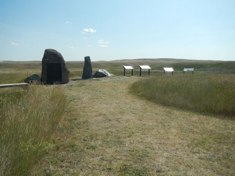
For the exhausted Nez Perce, this site, known to them as ćáynim?a•lika?spe (Place of Manure Fire), appeared to be a good place to rest before continuing to Canada. Then a large force of U.S. soldiers surprised them from the east. After . . . — — Map (db m142832) HM
Striking on the run, the U.S. Army planned to surprise and overwhelm the Nez Perce camp. Along this ridge Nez Perce warriors fought back fiercely and stopped the cavalry charge. The surprise attack was blunted, but the Nez Perce were pinned down, . . . — — Map (db m142866) HM
C'Aynnim 'Alikinwaaspa is the Nez Perce name for this site. It means "Place of the Manure Fire" because the Nez Perce used buffalo chips as fuel here.
On September 29, 1877, about 700 Nez Perce men, women and children camped in the basin . . . — — Map (db m142830) HM
Two panels are affixed to a common boulder.
Commemorating the surrender of Chief Joseph and the remnants of his tribe of Nez Perce to General Nelson A. Miles, October 5, 1877.
Here Chiefs Looking Glass, Ollicut, Too-hul-sote and . . . — — Map (db m142802) HM WM
To the
everlasting
memory
of the
Brave Warriors
Chief Joseph's Band
who fought on
these grounds
in the
Nez Perce War
of 1877
Erected by
Nez Perce Indians
and the
Chief Joseph Memorial
Association . . . — — Map (db m142865) WM
With the fighting at a standoff, Hinmatóowyalahtq̓it (Chief Joseph) met with Colonel Miles near this site. Surrender was a survival strategy, to keep the Nez Perce people alive and together. One witness reported that Chief Joseph spoke . . . — — Map (db m142869) HM
These rolling hills and coulees are the site of the last battle of the 1877 Nez Perce War. For the Nez Perce this was the end of a 1,170-mile journey, after many successful skirmishes along the way. Canada was only 40 miles farther, its mountains . . . — — Map (db m142833) HM
About noon the families made camp. The scouts killed several buffalo. This place is ćáynim?a•lika?spe (Place of Manure Fire) .... Some warriors were on the buttes watching for enemies. We expected none. -- himi・n maqsmáqs . . . — — Map (db m142838) HM
This park links a series of widely separated sites of deep significance to the Nez Perce – historic villages, battlefields, and legend sites. The park experience involves a journey across both time and territory. Although firmly connected to . . . — — Map (db m142831) HM
The large depression is the site of a mass grave. Here the U.S. Army buried its casualties from the battle. This ridge is also the site of a hastily erected field hospital -- just a tent were surgeons tended and operated on the wounded. In 1912 the . . . — — Map (db m142868) HM
From where the sun now stands I will fight no more forever.
October 5 1877
Surrender of Chief Joseph to Colonel Nelson A Miles
To the valor and devotion of those both red and white who struggled here
Erected by the Congress of . . . — — Map (db m142801) HM
This battle was fought September 30 to October 5, 1877, on Snake Creek, about 20 miles south of here near the Bears Paw Mountains, where after five days days' siege Chief Joseph, one of five remaining Nez Perce leaders, surrendered to Col. Nelson . . . — — Map (db m142800) HM
Fort Belknap Reservation was established in 1888 when Gros Ventres, Blackfeet, and River Crows ceded to the government 17,500,000 acres of their joint reservation that had covered all of northern Montana east of the Rocky Mountains. Home for the . . . — — Map (db m142915) HM
High points such as mountaintops and tabletop buttes are considered powerful and sacred areas by many Indian peoples. Snake Butte is one such location, often used as a place for the spiritual rite of vision questing. The individual vision quest is . . . — — Map (db m205818) HM
On a quiet night, nine miles north of Harlem, Montana the lives of thirteen airmen were lost when two C-141B Starlifter Cargo Planes collided. The thirteen crew members from McChord Air Force Base were on a low level refueling exercise on that . . . — — Map (db m142910) WM
Fifty-five to thirty-four million years ago, volcanoes erupted in several areas of central Montana. The upwelling of magma which fed these volcanoes was largely responsible for the Bears Paw Uplift and for several other isolated mountain ranges in . . . — — Map (db m142530) HM
According to legend, the town and the creek got their name from the muleskinner "Big Sandy" Lane. The creek was flooded during one of his long treks from Cow Island to Fort Benton. When "Big Sandy" fluently bewailed his bad luck in superlatives . . . — — Map (db m142531) HM
July 10, 1866 - March 31, 1870
Near this spot soldiers of the 13th Infantry of the U.S. Army built the first permanent Army post in the Montana Territory, where the Judith and Missouri Rivers join together. — — Map (db m161911) HM
Freight was unloaded at Cow Island when water dropped so low that steamboats could not travers the upper river to Fort Benton. For 130 miles the Cow Island Trail wound along the southern foothills of the Bear's Paw to the junction at Big Sandy then . . . — — Map (db m142562) HM
In the spring of 1844, American Fur Company traders, Francis Chardon and Alexander Harvey constructed a trading post near here. Chardon had a reputation as an able and unscrupulous individual, while Harvey was "one of the most abandoned desperados . . . — — Map (db m161839) HM
Another wagon road headed northeast from Fort Bento to the Cypress Hills and Medicine Hat, Alberta. It passed through Big Sandy, on north near Havre and into the Cypress Hills. In 1873 Fort Benton whiskey traders massacred Indians in the Cypress . . . — — Map (db m142558) HM
The road to the southeast leads to the mouth of the Judith River. An early fur post, Fort Chardon was built there in 1844. In 1866 Camp Cooke, the first miliary (sic) post in Montana, was constructed of cottonwood logs, and endured four years of . . . — — Map (db m142559) HM
Like much of Montana, the lands of the Wortman Ranch still look largely as they did even before the days of Lewis and Clark. Except for the irrigated farmland next to the river, the landscapes here haven't changed in character or appearance for . . . — — Map (db m161903) HM
Gaze out over the lands around you and imagine them filled with 2,000 tidies and 15,000 Indians-it has happened at least twice. Here, enormous gatherings were called to negotiate treaties that transformed relations between Indian tribes and opened . . . — — Map (db m161905) HM
You stand now in an area that was one of the first to feel the rapid growth of immigration that began about 60 years after Lewis and Clark camped here. Steamboats in the late 1800s chose this area as a key stopping point, because the trees needed . . . — — Map (db m161840) HM
In 1855, geologist Ferdinand V. Hayden explored the upper Missouri River for the United States Geologic Service. At that time, the area was the hunting grounds of the Lakota, Blackfeet, Atsina, and River Crow Indians. A lone white man in Indian . . . — — Map (db m161838) HM
Once home to grazing dinosaurs, the lands surrounding you still exhibit the qualities that have mad the Judith Landing area an important crossroads thought human history. Here, at the confluence of two rivers, trees grow more densely than elsewhere . . . — — Map (db m161936) HM
On June 4, 1805 while Captain Lewis was exploring Maria's River, Captain Clark explored the Missouri up form the Carter Ferry site. In Clarks's small party were Sgt. Glass, the Field brothers, G. Shannon and York.
Captain Clarke noted that . . . — — Map (db m245917) HM
On June 12, 1805 Captain Lewis left Grog Springs, climbed up to the plains and headed "West of S.W." with Drewyer, Gibson, Goodrich and Joseph Field. After a twelve-mile hike, they returned to the river for water were they killed tow large grizzlies . . . — — Map (db m245896) HM
George Montgomery, youngest of 15 siblings, was born on a homestead near Brady, Montana. Following graduation for Great Falls High School, and one quarter at the University of Montana, he headed for . . . — — Map (db m142336) HM
The bank was established June 1, 1880, by T. E. Collins, Charles Duer and L. H. Hershfield and Brother. It was first located in the Benton Record Building, then moved to this location in October 1881. The bank remained here until the large . . . — — Map (db m142100) HM
"It's a tough town. Walk in the center of the street and keep your mouth shut," Gunslingers walked this street; few earned a reputation but more earned eternity here than in other fabled western towns.
Indians were fair game. Their corpses . . . — — Map (db m142304) HM
This is a replica of the buffalo robe press that was used at Old Fort Benton. It was big and awkward, but robes were so bulky and heavy that it took equipment like this to handle them. Robes were pressed hair-side out after the four sides were . . . — — Map (db m142212) HM
I.G. Baker and T. C. Power built the original Thwing House in 1868. Under the watchful eye of Mrs. Thwing, this “downtown” hotel competed with the Overland. The hotel closed in 1870 and was rented as military officers’ quarters. It . . . — — Map (db m142134) HM
When Lewis and Clark found this land of mountains, river valley and plains, it was so full of buffalo and other grazing animals that it seemed like Paradise. In the1880's the area became vast open cattle ranges, and today Montana's greatest wheat . . . — — Map (db m142014) HM
Chouteau County was one of the nine original counties created February 2. 1865. At that time there was a sporting disregard for assessors, taxes and the law. For example, in 1872 when the jail burned, all the peace officers were in Canada trading . . . — — Map (db m142450) HM
Minneapolis architects Kees and Fisk drew the plans for this magnificent Queen Anne style courthouse which opened in 1884. As the seat of one of Montana's nine original counties, its grand appearance represents the early affluence of this "Chicago . . . — — Map (db m142451) HM
The Roman Catholic faith came to Fort Benton even before the walls of the fort were erected. Father Jean Pierre de Smet and Nicholas Point celebrated the first mass on Sept. 27, 1846. "Black Robes" continued to serve the area irregularly until Fr. . . . — — Map (db m142452) HM
When fire destroyed the original Church of the Immaculate Conception in 1905, this beautiful Tudor style structure of rough cut stone and ornamental half-timbered gables replaced it in 1907. Salvaged from the blaze was a bell christened in 1880 for . . . — — Map (db m142454) HM
The Coulson Steamboat Headquarters once stood here. The Coulson Line was the largest early company on the upper river. It ran some of the most immense boats, like the Montana and the Dakota, that were over 250 feet long. Coulson . . . — — Map (db m161592) HM
On September 21, 1877, Fort Benton commander Major Guido Ilges got word that the Nimíipuu (Nez Perce) had traveled across the Judith Basin headed for Canada. Thirteen members of Company F, Seventh Infantry Regiment and to civilians . . . — — Map (db m161479) HM
Solomon's Medicine Lodge Saloon was remodeled in 1875 and became the Centennial Hotel. This frame building was moved to the back of the lot by Robert S. and Lydian Smith Culbertson for living quarters, while a new two-story brick hotel was built . . . — — Map (db m142303) HM
Originally this site was occupied by a wooden frame building that housed Mose Solomon’s Medicine Lodge. This legendary saloon was open twenty-four hours a day from spring thaw to first snow. When the building burned, prominent lawyer, customs . . . — — Map (db m161662) HM
Fort Benton’s building boom of 1887-1884 saw the construction of many commercial buildings made of locally produced soft brick. This fine example was built in 1881 as a saddlery by Davidson and Moffitt of Helena. The River Press Company, publisher . . . — — Map (db m142064) HM
Thomas Francis Meagher was born in Ireland in 1823. An Irish Revolutionary, he was caught and sentenced to death. Meagher's sentence was commuted to exile in Tasmania but he escaped to the United States. As a Brigadier General, Meagher commanded the . . . — — Map (db m142253) HM
The threat of fire haunted Fort Benton's businessmen. They took several steps to minimize this risk before incorporating in 1883. A volunteer fire department of three companies of men was organized. Ten strategically located wells were placed along . . . — — Map (db m161663) HM
"Fire" was a cry dreaded by any Westerner, and early Fort Benton was no exception. Flimsy wooden buildings, haystacks, kerosene lamps and primitive stoves created major fire hazards. When city government was organized in 1883, the first steps in . . . — — Map (db m142424) HM
Founded in 1846 as a fur post, Fort Benton is the oldest continuously inhabited settlement in Montana. From its palisaded walls grew the most important transportation center in the Northwest. Trails led to all points of the compass, carrying goods . . . — — Map (db m141987) HM
Alexander Culbertson established Fort Benton in 1846 as an American Fur Company trading post. The remote settlement prospered in the 1850s, but it wasn't until the following decade that it really boomed. The arrival of the steamboat Chippewa at the . . . — — Map (db m142483) HM
The Fort Benton to Fort MacLeod or "Whoop-up" Trail into Canada was the main artery of commerce in the 1869-1883 era. Twenty yoke of oxen was a team and each team hauled three of the heavy freight wagons loaded with trade goods, calico and whiskey. . . . — — Map (db m142216) HM
This three-inch ordinance rifle came to Fort Benton sometime after the Civil War, probably during the time it was a military port, 1869-1881. It has remained here since its arrival, and was here during the Indian Wars of 1876-1877. It has seen no . . . — — Map (db m168229) HM
Fort Benton was the eastern terminus of the Mullan Military Road. Construction of the road began in the summer of 1859 at Fort Walla Walla, the head of navigation on the Columbia River. Lieutenant John Mullan of the U.S. Topographical Engineers . . . — — Map (db m142484) HM
When railroads replaced steamboats, Fort Benton's importance as a trade center declined. In response, Fort Benton businessmen formed the Benton Bridge Company to construct a bridge across the Missouri River to capture the trade of the rapidly . . . — — Map (db m142414) HM
The Fort Benton Engine House, built in 1883, and the Grand Union Hotel are two of only a few structures remaining to remind us of the rapid expansion here during the flourishing steamboat days. When Fort Benton incorporated in 1883, a volunteer fire . . . — — Map (db m142417) HM
Founded in 1846 as the fur trade transitioned fro furs to buffalo robes, Fort Benton was both a trading post and a center for distribution of Indian annuities. In the early 1860s, Montana's gold rush and the initiation of steamboat traffic made the . . . — — Map (db m142173) HM
On June 14, 1869 nine sternwheelers moored along this bank, unloading whiskey, gold pans, salt, bacon, boot and miners. Ox teams hauled the freight to faraway points. Wells Fargo coaches took miners to Helena for $25, fights with the Blackfoot were . . . — — Map (db m142060) HM
Joseph LaBarge docked the Emilie on June 17, 1862, three days ahead of the American Fur Company boats. His Emilie was the first side-wheeler at Fort Benton. LaBarge unloaded six hundred tons of freight with is partner James Harkness. . . . — — Map (db m161587) HM
As you look across the Missouri, on the third bottom were two fur posts within several hundred yards of one another. Fort Cotton, built in 8142 by the Union Fur Company, existed only two years before it was abandoned. Fort Lewis was built by . . . — — Map (db m142017) HM
Opened to the public Nov. 1, 1882 the Grand Union Hotel was Fort Benton's pride, a haven of relaxation in a boisterous frontier town at the head of navigation on the Missouri. Total cost of the finest hostelry between Seattle and the Twin Cities . . . — — Map (db m142061) HM
This grandiose, three-story Italianate style hotel welcomed weary river travelers to the Gateway of the Northwest, offering guests a luxurious refuge before setting out for less civilized destinations. Its opening in 1882 came at the end of the . . . — — Map (db m142062) HM
In the 25 years following the first gold discoveries in western Montana, before railroads arrived in Fort Benton 1887, steamboats made hundreds of trips bringing fortune-seekers and their supplies from St. Louis to Fort Benton. Some of the boats . . . — — Map (db m161580) HM
Across the levee on the corner stood the two-story house built by the sheep man Paris Gibson who was the founder of Great Falls. He later became a promoter for James J. Hill's railroad. In 1887 while negotiating the entry of the railroad into Fort . . . — — Map (db m161589) HM
This structure opened in 1882 during Fort Benton’s "glory days" as Montana’s largest hardware store. T. C. Power and Hans Wackerlin operated the business. Wackerlin, a tinsmith, had come to Fort Benton in 1867 aboard the steam boat Richmond, which . . . — — Map (db m142136) HM
Stores, warehouses and homes belonging to Montana's greatest trading company were along this side street. Founded in 1866, I.G. Baker Co.'s freight wagons cut deep trails into western history. From northern Canada along routes in all directions, the . . . — — Map (db m142292) HM
From the 1850s to 1887, Fort Benton was the trade center for this region of the American and Canadian West. Like others who chose to stay when the fur trade declined, I.G. Baker (last American Fur Company factor at the fort) turned to new endeavors. . . . — — Map (db m142133) HM
The original portion of this house, one of the oldest in Montana, was built for I.G. Baker in 1867. Early-day Fort Benton merchant Baker wanted a home, rather than the old fort for the birth of his expected child.
Constructed of rough-sawn . . . — — Map (db m142290) HM
On this day water from the Missouri River rose to this level at this location due to heavy rainfall over Western Montana.
For more information contact
National Weather Service Great Falls, MT
www.weather.gov/greatfalls
Missouri . . . — — Map (db m142408) HM
Keelboats antedated steamboats and used every kind of power–chiefly man–except steam. Propelling them was no idle pastime. The usual method was to set long ash poles on the river bottom, toe the cleated walk and push hard, bow to stern. Crew also . . . — — Map (db m142245) HM
The river below was the first trail west. On their way to the Pacific, Lewis and Clark used the Missouri as their route to the Rocky Mountains. Maria's River enters the Missouri fifteen miles down stream. In June 1805 the Captains spent ten days . . . — — Map (db m142016) HM
On July 16, 1806, Captain Lewis gave instructions to Sgt. Ordway to finish the portage at the Great Falls and wait for him at the month of Maria's River. After their wild encounter with the Blackfoot on the Two Medicine and a twenty-hour ride, . . . — — Map (db m142214) HM
Members of Masonic Lodge #25 built this brick structure in 1882, housing their temple on the second floor. Grocer W. H. Burgess rented first floor space. Economic decline in the late 1880s caused the Masons to lose title, and Burgess, too, went . . . — — Map (db m142103) HM
Originally built to house the Stockmen’s National Bank, this solid structure represents typical pre-1900s commercial architecture. Its 1890 construction is significant as one of the few buildings erected after Fort Benton’s heyday and before . . . — — Map (db m142102) HM
On July 19, 1882 the steamer Rose Bud docked at the Fort Benton levee. That night the residents got their first glimpse of an electric light with a show from the the steamer's big searchlight, much to the chagrin of a prominent local . . . — — Map (db m161581) HM
Within a few steps of this sign the Mullan Road came up Helena Hill from Fort Benton. It wound its way over 600 miles to the head of navigation on the Columbia River at Fort Walla Walla. It was the first federal highway in the Northwest. Covered . . . — — Map (db m141986) HM
Captain John Mullan started surveying the Mullen Road in 1853 and began construction in 1859 of the 624-mile wagon road that linked Fort Benton to the head of navigation on the Columbia. Indian wars slowed him somewhat, but Mullan opened his route . . . — — Map (db m142246) HM
Across the street is a log house that was occupied by Major Guido Ilges, commander of the troops at Fort Benton during the Indian Wars of 1876-1877. Ilges took a volunteer force of eighteen men to Cow Island where they confronted the Nez Perce . . . — — Map (db m161591) HM
In September 1877 the Nez Perce traveled across the Judith Basin headed for Canada. In anticipation of trouble, Major Ilges (commandant at Fort Benton) organized a party of fifty volunteers, mostly Fort Benton's Irish Fenians. They loaded the . . . — — Map (db m142215) HM
Logs were floated downstream from Fort Lewis in May of 1847 and erected on foundations built the year before. The fort was called Fort Lewis or Fort Clay before officially named for Senator Thomas Hart Benton of Missouri upon completion of the . . . — — Map (db m142210) HM
The bridge at this site was completed in 1888 and remained in use until 1963. The Benton Bridge Company constructed it as a toll bridge–no federal subsidy, county or state money was involved–to encourage the city's Judith Basin trade. . . . — — Map (db m142333) HM
On this site stood old Fort Campbell; it was the "opposition fort" to Fort Benton downriver. Fort Campbell was moved here by Alexander Harvey in 1847 and built of adobe.
Harvey was a fearless frontiersman, a character whom no one heedlessly . . . — — Map (db m161593) HM
In the late 1870's after the gold rush, stockmen began to move cattle from the mountains to the northern plains of Montana and utilize the free grass on the open ranges. Montana's short grass prairies had the best grass of the entire Great Plains. . . . — — Map (db m142339) HM
In 1864, Mills and Douglas operated a restaurant and hotel on this corner. Mills and Robert S. Culbertson went into partnership in 1877, opening a new establishment called the Centennial Hotel in celebration of the United States' 100th birthday. . . . — — Map (db m142104) HM
Civilizations have always established themselves around water sources, and the founding of Fort Benton continued the pattern. As the population grew and the community developed, a water treatment plant became necessary.
Montana's first water . . . — — Map (db m161579) HM
In August 1936 a casket containing a sheepherder's body was loaded on a baggage car headed East for burial. A dog, of collie strain, watched with anxious eyes. He was to be there to meet every train year after year.
Conductor Ed Shields by 1939 . . . — — Map (db m142059) HM
The Episcopal Church came to Montana Territory with Bishop D.S. Tuttle in 1867, who rode horseback to mining camps and frontier posts. An abandoned saloon housed the first Fort Benton services, then a hotel and school.
When Rev. S.C. Blackiston . . . — — Map (db m142328) HM
St. Paul’s Episcopal Church, Fort Benton’s oldest church, is the oldest Episcopal Church in Montana. In continuous service since August 11, 1881, it appears today almost as it did upon opening. Architecturally, this Gothic style building is a fine . . . — — Map (db m142329) HM
Stages operated from Fort Benton in many directions well into the 20th century. The first routes connected the gold camps of Helena and Virginia City with the river port. In 1866 C.C. Huntley established the route, but was soon bought out by . . . — — Map (db m161659) HM
Just over the brow of this hill, nestled against the banks of the Missouri, is Fort Benton. It was the head of steamboat navigation on the Missouri, the world's innermost port. Below this point is a shelf in the river that prevented further passage. . . . — — Map (db m142011) HM
Part of the remains of Fort Benton's last steam boats.
Baby Rose & City of Fort Benton were both lost on the Missouri after 1900. — — Map (db m142170) HM
Originally built to house the Stockmen’s National Bank, this solid structure represents typical pre-1900s commercial architecture. Its 1890 construction is significant as one of the few buildings erected after Fort Benton’s heyday and before . . . — — Map (db m142101) HM
This stream flow monitoring station is part of a nationwide system of approximately 7,000 streamflow stations operated by the U.S. Geological Survey (USGS). The USGS has principal responsibility for evaluation of the Nation's water resources by . . . — — Map (db m142410) HM
Across the street stood the first two stores of the T.C. Power Company, the third became the Pioneer Lodge. T.C. Power stepped off the Yorktown about this spot on June 14, 1867 with a tiny stock of merchandise bought "on jawbone," but with . . . — — Map (db m142248) HM
In 1867, merchant T. C. Power, destined to become one of the state’s wealthiest and most influential men, brought his first wagonload of goods to Fort Benton, where he set up shop in a borrowed tent. Still in business in 1916, Power constructed a . . . — — Map (db m142137) HM
T. C. Power and Bro. was founded in 1868 at approximately this location. Initially housed in a wooden building, the store was moved in 1879 to a large brick structure across the street. When the firm expanded, a hardware store was built next door . . . — — Map (db m142135) HM
Originally a pretentious two-story frame hotel familiar to all rivermen, the Choteau House was built in the spring of 1868. T.C. Power and I.G. Baker constructed the building between their businesses to rival Overland up the street.
At . . . — — Map (db m142289) HM
In 1850 this building housed families of the engages in the two large second-story rooms accessed by two exterior stairways. It was communal living, but it was warmer and better living than a tepee. Downstairs were shops for the skilled craftsmen. A . . . — — Map (db m142449) HM
You stand now on the ancestral homeland of nomadic native tribes whose territories overlapped in the Missouri River area-all of them drawn by the rich diversity of life sustained by the river itself. Blackfeet, Gros Ventre, Sioux and Assiniboine all . . . — — Map (db m161481) HM
226 entries matched your criteria. The first 100 are listed above. Next 100 ⊳