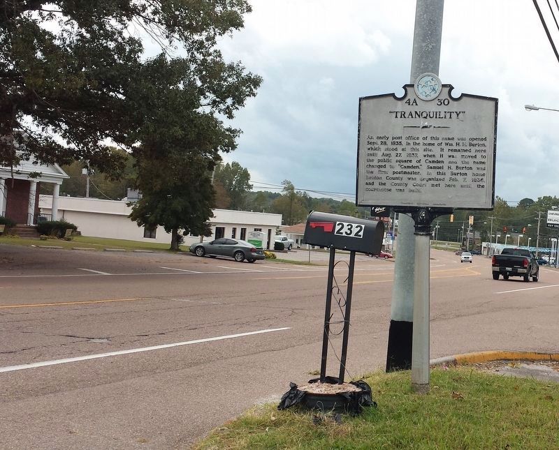
An early post office of this name was opened Sept. 28, 1835, in the home of William H.H. Burton, which stood at this site. It remained here until Aug. 27, 1837, when it was moved to the public square of Camden and the name changed to "Camden." . . . — — Map (db m109047) HM
Born 1779, South Carolina, died 1860, Benton County Tenn. Citizen soldier, War of 1812, member of Benton County's first quarterly court February 1836. Patriot for whom Benton County was named. Presented to the Citizens of Benton.
(Base monument) . . . — — Map (db m74482) HM
During the Civil War, several engagements occurred along the strategically important Tennessee River within about five miles of here. In each one, cavalrymen engaged naval forces.
On April 26, 1863 near the mouth of the Duck River east of here, . . . — — Map (db m74512) HM
8½ miles east, at Johnsonville Landing, Forrest's Cavalry Corps, after blocking river approaches from both directions with captured Federal vessels and gunfire, destroyed the Federal base at Johnsonville. Losses were 4 gunboats, 14 steamboats, 17 . . . — — Map (db m237476) HM
U.D.C. Marker to eight Irish CSA soldiers
probably worked on railroad
1860-1861
Erected by
Captain Nathaniel A. Wesson
United Daughters of the Confederacy
1992 — — Map (db m109049) WM
Mary Cordelia Beasley-Hudson, a life-long resident of Benton County, was an advocate for women's suffrage. The Tennessee General Assembly approved an amendment to the state constitution to allow women's suffrage on April 15, 1919. Seven days later . . . — — Map (db m81359) HM
On March 5, 1963, at 30 years of age, country singer Virginia Patterson Hensley, better known as Patsy Cline, along with her manager, Randy Hughes, and fellow Grand Ole Opry stars, Hawkshaw Hawkins and Cowboy Copas, were killed in a plane crash in . . . — — Map (db m184907) HM
Mildred Jolly Lashlee was the first woman elected to the Tennessee Senate for a full “regular” term. Elected in November 1944, she represented the 26th Senatorial District. Before her election she was appointed to complete the term of . . . — — Map (db m109048) HM
Born June 2, 1863, in a log cabin, about ½ mile N., he studied law at Charlotte, later began practice at Camden. Attorney General of the 13th Judicial District, 1908-12, he was the last Tennessee governor to be elected by a convention. . . . — — Map (db m74481) HM
Some of the lesser known battles and incidents of wars have afforded drama and have portrayed characteristics of the participants far beyond those of usual recorded history. Such was the Battle of Johnsonville, fought between Maj. Gen. N. B. . . . — — Map (db m146444) HM
In 1862 and 1863, Confederate cavalry raids along the Louisville & Nashville Railroad often shut down operations and slowed the flow of supplies into Nashville. The Union army built a supply depot at Johnsonville to help alleviate the disruptions. . . . — — Map (db m171324) HM
The logs for this cabin were taken from a barn owned by Mr. James Sykes of Eva. The barn was used by scouts for General Nathan Bedford Forrest during a reconnaissance of the Pilot Knob area on November 4, 1864. The lower story of the Syke's home . . . — — Map (db m171323) HM
"The river, a small rivercraft landing, its proximity to the N. B. Forrest State Park, and the Methodist assembly ground…make it attractive to visitors."
- Tennessee County History Series
The town of Eva began its . . . — — Map (db m183537) HM
Below the hill to your front and concealed by thick brush, Confederate troops under the command of Maj. Gen. Nathan Bedford Forrest constructed five artillery positions to deploy guns against the Union supply depot at Johnsonville. On November 3, . . . — — Map (db m146438) HM
By the fall of 1864, the Civil War was not going well for the Confederacy. The Union invasion of the Deep South continued to ravage both the military and civilian population of the war-torn region. In an attempt to halt the advance, Confederate Lt. . . . — — Map (db m146440) HM
(side 1)
Commemorating the capture
of Federal gunboats
by Forrest's cavalry in the
Johnsonville Expedition
November 4, 1864.
(side 2)
"Faith is the duty of the hour."
N.B. Forrest, Major-General
to . . . — — Map (db m146443) WM
"In those days, that was how you got over there; there was no highway”
-Ken Ingram
The track leading to the Tennessee River
Railroad Bridge once started here. The
nearby depot served as the debarkation
point for . . . — — Map (db m183534) HM
Take Exit 133, State Route 191, and drive north to visit two state parks associated with the struggle to control the Tennessee River during the Civil War.
In 1861, the Confederates built Fort Donelson on the Cumberland River and Fort Henry . . . — — Map (db m96639) HM
Late in 1862, the Union army Gen. Ulysses S. Grant threatened Vicksburg, Mississippi. Confederate Gen. Braxton Bragg ordered Gen. Nathan Bedford Forrest to sever Grant's West Tennessee supply line, which extended from Columbus, Kentucky, via the . . . — — Map (db m118580) HM
Born in Cannon County in 1890, James Harvey Cummings, known as "Mr. Jim," was a farmer, attorney, politician, and statesman. Having served in the Tennessee General Assembly from 1928 to 1972, except for 1949 – 1953 when he was Secretary of . . . — — Map (db m60422) HM
(North side)
To honor the memory, the
patriotism, the deeds of valor
and sacrifices of Cannon County's
Confederate soldiers of the period
of 1861-1865
Erected by Cannon County Chap-
ter United Daughters of the
Confederacy . . . — — Map (db m177931) WM
Cannon County
Established 1836; named in honor of Newton Cannon Governor of Tennessee, 1835–39; Member of Congress, 1814–17 and 1821–27; Served in Creek War and War of 1812.
Warren County
Established . . . — — Map (db m60421) HM
On Short Mountain, 7.1 mi., Henry Hoover & John Beeson established a millstone and grindstone factory in 1806. An inscription on a bluff of the mountain, and discarded fragments of stone mark the spot. — — Map (db m60423) HM
The East Fork Stone's River originates approximately 7 miles to the east, at a spring on
Short Mountain. Stone's River is named after
Uriah Stone, a member of a party of longhunters
who explored a section of the river in 1767.
Beginning in the . . . — — Map (db m150447) HM
Here Forrest, with his newly organized brigade of about 1400 cavalrymen, halted for a short rest before making his successful raid on Federal forces at Murfreesboro under Gen. T.L. Crittenden. He freed a number of hostages from this locality and . . . — — Map (db m76173) HM
This stone was erected and used as a mile marker during the 1800's for what is now U. S. Highway 70S. Before the settlement of Europeans to this area, the route was known as the Black Fox Trail by Native Americans. During the 1800's the road was . . . — — Map (db m150448) HM
In the valley to the south, that part of the Cherokee nation which took part in the enforced overland migration to Indian Territory rested for about three weeks in 1839. About 15,000 persons of various ages took part in the march. Several who died . . . — — Map (db m254349) HM
Woodbury, located on the Murfreesboro-McMinnville Turnpike, experienced two significant Civil War actions in 1862–1863.
On July 12–13, 1862, when Confederate Col. Nathan Bedford Forrest marched through Cannon County to raid . . . — — Map (db m150449) HM
A tribute of love to the memory of those we must not forget-World War I-Army-
World War II-Navy
Eternal rest grant unto them oh Lord and let light shine upon them.
World War I-II erected by Veterans of Foreign Wars, American Legion, American . . . — — Map (db m107685) WM
On this site in 1796, Braxton Lee and family settled on 640 acres of land along the Cumberland River. In 1807 Lee was commissioned captain of the 20th Tennessee Regiment, Davidson Militia and served as Justice of the Peace for many years. Many early . . . — — Map (db m165440) HM
Located on this three-acre site, the original
42' x 48' brick structure was completed in 1869
at a cost of $12,000. The first-floor offices
and the courtroom on the second floor of the
original structure are still in use today. The . . . — — Map (db m165958) HM
Edwin Clifton and his wife, the former Nancy Folks are buried in the old cemetery on a hillside above Hwy.12, opposite the spring used by the early members when their meeting house stood nearby. Many graves there are not marked; however, Edwin's . . . — — Map (db m165457) HM
(Side A)
The church stood on a hill across Hwy. 12 on Neptune Rd. from 1888 until it was struck by lightning 5/16/1984 and burned to the ground. A grove of trees marks the historic spot. The church was named for Edwin Clifton who built first a . . . — — Map (db m165453) HM
As Chairman of the Parks and Recreation Commission,
Mr. Johns began recreational baseball for the youth of
Ashland City. He organized the Dixie Youth Program
and Dixie Boys Program. J. W. served as State Director
for Dixie Boys, and Vice . . . — — Map (db m192590) HM
Pioneer settlers arrived in the area from No. & So. Carolina as early as 1808. Civil War soldiers camped here on their way to Clarksville & Nashville. The community was named when a post office opened in 1882. In 1883 the village had blacksmith . . . — — Map (db m151790) HM
In 1885 J.T. Mosely deeded this property for use as a school or church for African Americans in the Neptune Community. To enhance the quality of public education for African Americans in rural Cheatham County, school officials built Neptune School . . . — — Map (db m151795) HM
Richard and Hazel Head moved their family to Cheatham County in 1966 so their daughter,
Pat, could play basketball. A 1970 graduate of Cheatham County Central High School and a
1975 graduate of the University of Tennessee-Martin, Pat played in the . . . — — Map (db m165476) HM
In the year 1790, Benjamin Darrow began operating a cotton gin and grist mill along
Sycamore Creek, In 1835, on the site of the old Darrow Mill, Robert and Edward Cheatham
along with Samuel Watson erected a powder mill which operated until the . . . — — Map (db m151807) HM
The son of C. Hyde and Vina (Hale) Stump, Thomas Jefferson Stump was born in Cheatham County on February 18, 1870 and was educated in Cheatham and Dickson Counties. On October 27, 1895, he married Henrietta Dozier. They had two sons. Stump engaged . . . — — Map (db m151786) HM
In November 1863, Federal troops occupied Kingston Springs to serve as headquarters for the supervisors of the U.S. Military Railroad Construction Corps. They oversaw the construction of this section of the Nashville and Northwestern Railroad. . . . — — Map (db m69365) HM
Across the river are the remains of an 800-year old town built by ancient Native American Indians. Almost surrounded by the river, it was also guarded by a high palisade wall. A large temple mound and several smaller mounds surrounded an open plaza. . . . — — Map (db m143825) HM
The Narrows of the Harpeth is rich in natural and cultural features. The most beautiful and unusual natural feature is the long narrow wall of limestone surrounded by a five mile loop of the river that returns to within 200 feet of itself . . . — — Map (db m248944) HM
4.1 mi. northwest, at The Narrows, Montgomery Bell, pioneer industrialist, ironmaster, philanthropist and turfman, built a forge in 1818. Power was obtained by tunneling water through the hill at the top of the Narrows to a point below it where the . . . — — Map (db m143827) HM
Prior to the Civil War, a rail line ran from Nashville to
Kingston Springs. After the federal seizure of Nashville
in 1862, work began to extend the line westward from
Kingston Springs to Johnsonville, providing another
supply line for the . . . — — Map (db m205515) HM
This tribute honors all the brave men and women of South Cheatham County who have served in our armed forces during times of war and peace, preserving the freedom we enjoy today. — — Map (db m205521) WM
Located on the Daniel Young 2,059 acre Land Grant No. 2419 of June 29, 1784 and the Robert Weakley North Carolina 640 acre Grant No.342 of September 24, 1787 where John Turnbull of Natchez, MS corralled his herds adjoining the headwaters of Spring . . . — — Map (db m151810) HM
Butler's Landing Daniel Boone, on his trip to the Western Territory in 1773, followed the old game and Indian trail to where two creeks flowed into the Cumberland River. He referred to them as the Twin or Double Creeks in his journal. On this . . . — — Map (db m74336) HM WM
During the Civil War, the residents of the eastern and Cumberland River sections of present-day Clay County (then part of Jackson and Overton Counties) were usually Confederate sympathizers, while those in the western section supported the Union. . . . — — Map (db m74297) HM
Honoring those who gave
the supreme sacrifice
from
Clay County
Reverse:
Spanish American War
Stanley G. Wright
World War I
Bedford Sherman Bean • Ezra A. Brown • John S. Bean • John E. Cherry • Stone F. Cherry • . . . — — Map (db m157355) WM
Constructed and operated by Corps of Engineers Department of the Army.
This is one of a series of dams in the Cumberland River Basin for flood control, power, navigation and water conservation.
Height of dam - 185 ft. Length of dam - 1,717 . . . — — Map (db m91771) HM
Dale Hollow Dam 1942-1943
Congress authorized the construction of Dale Hollow Dam in 1938 to reduce flood damages in the Cumberland, Ohio, and Mississippi River Valleys. Designed by the U. S. Army Corp of Engineers and built by private . . . — — Map (db m235590) HM
Capt. Jacob C. “Jake” Bennett, a native Kentuckian and noted Confederate partisan ranger, is buried in Donaldson Cemetery (four miles north of here). During the war, bushwhackers and guerrillas on both sides raided the sparsely populated borderlands . . . — — Map (db m112197) HM
Free Hill(s), a historic Black community, was established northeast of Celina before the Civil War by former slaves of Virginia Hill. Hill brought her slaves from North Carolina to then Overton County, purchased 2,000 hilly and rough acres, settled . . . — — Map (db m74274) HM
On September 25, 1830, Mary Ann (Hudspeth) Webb (ca 1772-1842) used the proceeds from the sale of her land holdings in North Carolina to buy 200 acres of land in Overton County, located on the east side of the Obed River, about 1 ½ miles . . . — — Map (db m112216) HM
On the knoll 400 yards to the east is the house, built between 1780 and 1782 by this Pennsylvania Quaker, who reportedly migrated here to avoid military service. At the time of its building, this territory was part of Washington District of North . . . — — Map (db m157353) HM
The Clay County Courthouse, 1873, has been listed in the National Register of Historic Places by the United States Department of the Interior. — — Map (db m183687) HM
The William Hull building — constructed in 1898, (photograph taken in 1913)
William Hull, 1840 - 1923, a small man with flashing black eyes, was a pioneer lumberman in Clay County, the #1 lumber producer in the USA 1880-1920. Wm. Hull . . . — — Map (db m157359) HM
Hermitage Springs was first called Trace because of its location in Big Trace Creek valley. The community existed of only a few scattered residences and a small log church that became known as the Hermitage Springs Church of Christ. Established . . . — — Map (db m177398) HM
[Top side]
The access highway to AEDC is renamed
Wattendorf Memorial Highway
19 June 1987
in honor of
Dr. Frank L. Wattendorf
a distinguished engineer and scientist and a pioneer in the development of aeronautical . . . — — Map (db m184057) HM
This F-14-D Tomcat is dedicated in memory of LT Kara Hultgreen United States Navy. On 25 October, 1994 the Black Lions of Fighter Squad 213 were conducting training operations in preparation for deployment to the Persian Gulf aboard the aircraft . . . — — Map (db m184032) HM WM
This F-105 Thunderchief is dedicated in memory of Lt. Gen. Robert M. Bond, who died in service to his country. General Bond flew the F-105 both as a test pilot and combat pilot. As vice-commander of Air Force Systems Command, he was ever mindful of . . . — — Map (db m184049) WM
This F-15C Eagle is dedicated in memory of Major James Duricy United States Air Force. On 30 April 2002 his F-15C was conducting flight tests of the AIM-9X Sidewinder Missile when a large section of the F-15's tail broke off at Mach 2. The aircraft . . . — — Map (db m184042) HM WM
Hoover's Gap, TN. June 24, 1863. The 18th Indiana Battery, commanded by Capt. Eli Lilly, dislodged one Confederate artillery piece and forced the Confederate batteries to change position. The battery, along with Wilder's Brigade, did considerable . . . — — Map (db m81374) HM
On June 24, 1863, Union forces under Rosecrans overpowered Confederate defenders on Hoover's Gap, commanded by Stewart, Bate, and Bushrod Johnson. This was the beginning of Bragg's withdrawal to Chattanooga. Unknown soldiers who fell in the battle . . . — — Map (db m26052) HM
Originally the site of a pioneer cemetery, many early residents are buried here. In 1866, returned Confederate soldiers, under the leadership of Maj. William Hume and David Lawrence, collected and reinterred here the bodies of soldiers who fell at . . . — — Map (db m286486) HM
Near here, on Garrison Fork, this fort was established, about 1793, for the protection of settlers and travelers to and from the southwest. Until its abandonment, about 1804, it was an important stopping place and administrative center. — — Map (db m26050) HM
(Front):General A.P. Stewart Stewart's Division 2nd Army Corps (Hardee) Army of Tennessee CSA Dedicated 24th Day of April 2010 By Benjamin F. Cheatham Camp 72 Sons of Confederate Veterans Manchester, Tennessee (Reverse):Battle of . . . — — Map (db m30698) HM
Forrest's Farewell Order to his Cavalry Corps ExtractGainesville, Ala., May 9, 1865 Civil war, such as you have passed through, naturally engenders feelings of animosity, hatred, and revenge. It is our duty to divest ourselves of all such feelings, . . . — — Map (db m30715) HM
Born in Washington, Feb. 16, 1840, where his father, Harvey Magee Watterson, was in Congress, he spent most of his boyhood in a house 100 ft. W. Subsequently Confederate soldier, journalist and political leader, he founded the Louisville . . . — — Map (db m81375) HM
The South is a land that has known sorrows; it is a land that has broken the ashen crust and moistened it with tears; a land scarred and riven by the plowshare of war and billowed with the graves of her dead; but a land of legend, a land of song, a . . . — — Map (db m24167) HM
From here, Maj. Gen. W.S. Rosecrans marched his reorganized army against Bragg's Army of Tennessee, in the Shelbyville-Wartrace-Tullahoma area. Fainting with his Reserve Corps and cavalry against Shelbyville, he drove through Hoover's Gap with his . . . — — Map (db m185615) HM
In Honor of the men of the Confederate 1st/3rd Kentucky
Calvalry (Consolidated) who first encountered the
onslaught of Wilder's Brigade, Thomas's Corps of the
Union Army, North of Hoover's Gap June 24, 1863 — — Map (db m166932) WM
Union Major General William S. Rosecrans' plan to reach Manchester and cut off a Confederate retreat to Chattanooga depended upon capturing Hoover's Gap. In the early afternoon of June 24, Colonel John T. Wilder and his brigade of 2000 mounted . . . — — Map (db m166843) HM
Spencer Repeating Rifle
The Civil War occurred during a period of technological revolution. In the 1850s, the US Army replaced its smoothbore weapons with the long-range rifle musket Then, just before the war, Christopher Spencer, a . . . — — Map (db m166844) HM
In late June of 1863, Union Major General William S. Rosecrans launched a massive offensive from his base in Murfreesboro in an attempt to drive Confederate General Braxton Bragg's 43,000-man Army of Tennessee from its entrenchments at Shelbyville . . . — — Map (db m180859) HM
This area, including the bridge over Little Duck River, has for years been known as "Jail Hill". Several jails have stood on this location. The first brick jail was completed in 1837, and was used as such until about 1857, when it was destroyed by . . . — — Map (db m268738) HM
Erected to honor all Coffee County Veterans who served our Nation throughout the Persian Gulf Area War
Operation Desert Storm 1990 - 1991 — — Map (db m158636) WM
Hereabouts, on June 20, 1941, Maj. Gen. George S. Patton, Jr., personally led his 2nd Armored Division across several fords of Duck River, quickly surrounding and defeating his maneuver opponents in the Manchester vicinity, thus proving that modern . . . — — Map (db m24968) HM
General "Hap" Arnold, WW II Commander of the Army Air Forces, is commemorated by the Air Force research and development installation bearing his name. In 1944, he directed long range planning for air research and development to maintain this . . . — — Map (db m25920) HM
The dam in front of you was built in 1963, three years before the Old Stone Fort became a Tennessee State Park. It was not associated with any of the industrial mills that once operated here. The river seen here is the Barren Fork or Big Duck River. . . . — — Map (db m277865) HM
This cemetery was established in the early 1800's, by the burial on this spot of David Hickerson and his wife Nancy Hickerson. It has been known throughout the years as the Granny Hickerson Cemetery, though members of other families are also known . . . — — Map (db m69657) HM
In honored memory of those who made the supreme sacrifice in the preservation of freedom for those oppressed people of South Korea and in memory of all Coffee County veterans who honorably served in the Korean War 1950 - 1953
May our love . . . — — Map (db m158635) WM
This area is open to foot traffic only and not wheel chair accessible.
You are now approaching the Town Square.
The original settlement of Manchester began in 1812, when a Mr. Eastland established a tavern at the foot on the hill known as . . . — — Map (db m268739) HM
During the nineteenth century, the Duck River was a valuable power source for factories and mills along its banks. With the outbreak of war in 1861, the Confederacy quickly established gunpowder mills to support the Southern war effort. The . . . — — Map (db m166935) HM
In the 1800s, industrialists found the waterfalls of the area an ideal setting for water powered mills and factories.
While the mills propelled the development of Manchester, today we are lucky to still be able to track most of the line of . . . — — Map (db m277771) HM
About 1/2 mi. S.W. are remains of stone fortification and moat of ancient and unknown origin. One theory is that it was built by a party of 12th Century Welch voyagers who entered the country via the Gulf of Mexico. Near here also was the capital of . . . — — Map (db m24967) HM
Around 2,000 years ago, Native Americans built a rock and earthen wall around a 50-acre hilltop plateau situated between the Duck and Little Duck Rivers. Here in 1966, archaeological investigations recovered artifactual and radiocarbon data . . . — — Map (db m166938) HM
The Highest Wall Segment
Here the mound wall follows the edge of the most abrupt drop-off and descends in elevation to stay on that drop off. As the base of the wall drops in elevation, it rises in built height. There is a notch built into . . . — — Map (db m277768) HM
Maneuvering in this vicinity, June, 1941, the 2nd Armored Division, USA, commanded by Maj. Gen. George Smith Patton, Jr., gave the first demonstration in America of the mobility and decisive power of armor in large-scale combat operations. Maneuver . . . — — Map (db m24969) HM
Ingredients:
The three essential ingredients to produce black powder are charcoal, saltpeter, and sulfur. When ignited, these 3 ingredients react together to form large volumes of expanding gases. This provides the propelling force to projectiles . . . — — Map (db m277773) HM
Until the invention of smokeless powder, gunpowder was used for all military operations and civil engineering. After gun powder was manufactured at a powder mill, it required a safe place for storage until it was distributed. Powder magazines were . . . — — Map (db m277778) HM
The Duck River (Big Duck or Barren Fork) once flowed through the abandoned river valley below you.
The larger fork of the Duck eventually broke through a portion of what is called the Backbone Ridge that you can see across the valley. This . . . — — Map (db m277767) HM
1382 entries matched your criteria. The first 100 are listed above. Next 100 ⊳