First part:
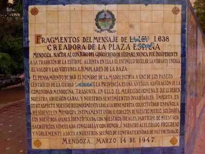
Fragmentos del mensaje de la ley 1.638.
Creadora de la plaza Espana. Mendoza.
No existe pueblo alguno de los innumerables que se alzan en los paises Americanos de habla espanola que no guarde con la madres . . . — — Map (db m79835) HM
It is called Cerro de la Gloria (1,000 meters above sea level) due to the fact that it hosts on the top the commemorative monument of the Army of the Andes. It was inaugurated on February 12, 1914.
It was originally known as "Cerro del Pilar." . . . — — Map (db m79322) HM WM
The oldest surviving building in Queensland, the Windmill, was constructed by convicts in 1828 to grind flour and maize meal as food for the Moreton Bay Penal Settlement. A stone and brick building, it contained two pair of mill stones - one pair . . . — — Map (db m100365) HM
Monument abstract This monument, a pathway of Independence, chronicles the foundation years of Barbados’ nationhood. Here, in this space renowned for recreation, learning and historical experience, we collectively celebrate 50 years of . . . — — Map (db m135176) HM
This building was constructed circa 1795 as Commissariat for the British Commission. Converted to the Garrison Theatre in 1893. Acquired by the Barbados Electric Supply Corporation in 1908. Renovated during 1986 75th year of operations. . . . — — Map (db m135153) HM
The Commonwealth War Graves Commission was established by Royal Charter of 21 May 1917
The Commisioner’s work was guided by fundamental principals which were established in 1920. That each of the dead should be commemorated individually by . . . — — Map (db m135051) WM
Engineer’s Office & Quarters
Built circa 1720
The oldest ‘house’ within the Garrison. Known today as the ‘Bush Hill House’ or the George Washington House and Museum. George Washington stayed here in 1751. Acquired for the ‘New’ Garrison . . . — — Map (db m134545) HM
The Barbados Cruising Club Salutes the Right Excellent Errol Walton Barrow On this Errol Barrow Day, January 21, 2018, the Barbados Cruising Club dedicates this memorial at our Aquatic Gap, Pebbles Beach home, to our first Treasurer and . . . — — Map (db m135034) HM
Hastings Barbados You Are Entering A UNESCO World Heritage Property Historic Bridgetown and its Garrison exhibits an important interchange of human values in the diversity of African, European and other ethnicities, and the confluence of . . . — — Map (db m135028) HM
1939-1945 To the enduring memory of those Barbadian Merchant Seamen who gave their lives in the Second World War Alle, E SS Inanda ∙ Anderson, FW SS Traveller ∙ Ashby, V SS Africa ∙ Atkins, G SS Traveller ∙ Bancroft, D SS . . . — — Map (db m135152) WM
Near This Spot Rest the Remains of Fourteen Soldiers And one Married Woman of the 36th Regiment who were killed by the destruction of the Barracks and Hospital during The awful visitation of the hurricane. August 11th, 1831. This Monument is . . . — — Map (db m135031) HM
Royal Artillery Barracks Built in 1812 Known today as Stafford House. The second storey arches were added after much of that floor was damaged during the 1831 hurricane. Originally used by the Artillery, this building was also later used to . . . — — Map (db m135030) HM
Sir Grantley Herbert Adams Q.C., C.M.G. 1898-1971 Leader of the Government and Premier of Barbados 1946-1958 Primer Minister of the West Indies 1958-1962 “He was ready at the time when the people needed a leader who would be both the . . . — — Map (db m135032) HM
The Barbados Military Cemetery This site is dedicated to the men and families of the British Forces who died serving in Barbados 1780 to 1906 Thanks to Barbados good military defences no enemy has ever landed on its shores Today this . . . — — Map (db m135035) HM WM
The Main Guard Built in 1804 Still known today as The Main Guard At the central point of the Garrison, this building was also used for courts martial, with prisoners held in the guard house at rear. Sold into private hands in 1906, it became . . . — — Map (db m135029) HM
Boulevard Adolphe Max
Anciennement boulevard du Nord, il fut rebaptisé en 1918 du nom du
bourgmestre Adolphe Max arrêté et déporté par les Allemands en 1914
pour son opposition à leurs exigences.
Adolphe Maxlaan . . . — — Map (db m242609) HM WM
Boulevard Emile Jacqmain
Boulevard de la Senne rebaptisé en 1918 du nom de cet échevin libéral
de l'Instruction Publique arrêté puis déporté par les Allemands en 1917.
Emile Jacqmainlaan
De Zennelaan werd in . . . — — Map (db m242235) HM WM
Ici s’erigea en 1818 première usine à gaz du continent sous les auspices du collège de bourgmestre et échevins de la Ville de Bruxelles et de la Société Civile MEEUS (English translation:)
Here was erected in . . . — — Map (db m223988) HM
The Royal
Flemish Theatre
This typical Flemish Neo-renaissance building was designed
by J. Baes to offer a permanent location to the Flemish
Theatre ("Vlaamse Schouwburg"). Inaugurated in 1887, the
theatre in fact was housed . . . — — Map (db m224962) HM
La courtine du Treurenberg
Ce tronçon de courtine reliait
la porte du Treurenberg
(démolie en 1760) à la tour du
Pléban, l'une des quatre tours
entièrement conservées de
la première enceinte urbaine
du XIIe siècle. En . . . — — Map (db m225312) HM
The Museum of the
National Bank of Belgium
The House of the Governor of the National Bank is the only
remaining edifice out of the enormous bank complex built
between 1860 et 1878 and designed by H. Beyaert and
W. Janssens. The . . . — — Map (db m225675) HM
(French:)Situation: relie la rue de Flandre, chaussée commerçante médiévale, à la rue du Rempart des Moines qui suit le tracé d'un ancien dispositif défensif dressé hors de la première enceinte.
Histoire: . . . — — Map (db m239637) HM
«Je me sens le frère de tous les hommes et l’hôte de tous les peuples»
Victor Hugo
En ce lieu, la famille Hugo a vécu de 1866 à 1871 (English translation:)
“I feel myself the . . . — — Map (db m241137) HM
Église Saint-Nicolas
Profondément enracinée dans l'histoire de la ville et imbriquée dans le tissu urbain, cette église gothique enrobée de
maisonnettes est issue d'une chapelle fondée au XIIe siècle
à proximité de la . . . — — Map (db m224205) HM
(French:)
De 11 decembre 1789,
les Bruxellois chasserent d'ici
l'armee de Joseph II,
episode determinant
de la Revolution brabançonne
combat mene par les belges
pour l'independance et la liberte
(Dutch:)
Op 11 . . . — — Map (db m238416) HM
Hôtel de Ville de Bruxelles
Entourant une cour
intérieure rectangulaire, cet
ensemble de bâtiments édifiés
a différentes époques demeure
malgré tout l'un des principaux
témoins de l'architecture gothique
civile du pays. Dù à . . . — — Map (db m239364) HM
Karl Marx feierte 1847/1848 in diesem Haus mit dem
"Deutschen Arbeiterverein” und der
“Association Democratique" sylvester
Er lebte von februar 1845 bis marz 1848 in Brussel
Lived in Brussels from February 1845 to March . . . — — Map (db m225047) HM
Le 26 aout 1830
Mme Abts
confectionna
ici les 2
premiers
drapeaux
belges
Den 26te
augustus 1830
vervaardigde
Mevr Abts
alhier de 2
eerste
belgische
vlaggen . . . — — Map (db m224199) HM
Devant cet edifice
furent decapites, le 5 juin 1568,
pendant la rebellion contre
l'autorite du roi d'espagne Philippe II,
les comtes d'egmont et de hornes,
illustres victimes de la repression
Voor dit gebouw werden . . . — — Map (db m225065) HM
”Il faut etre absolument moderne„
Ici s'élevait
l'hotel "A la Ville de Courtrai",
où le 10 juillet 1873,
Paul Verlaine blessa Arthur Rimbaud
d'un coup de revolver.
Plaque réalisée par la Communauté
Française de Belgique a . . . — — Map (db m225774) HM
Victor Hugo a habite cette maison en 1852
Victor Hugo woonde in dit huis in 1852
(English translation:)
Victor Hugo lived in this building in 1852. — — Map (db m223599) HM
Église Saint-Jean-Baptiste au Béguinage
Ce remarquable édifice baroque bâti entre 1657 et la fin
du XVIIe siècle utilise les substructions d'une
église gothique, elle-même érigée à
l'emplacement d'une chapelle des-
servant le . . . — — Map (db m242475) HM
Le Parc de Bruxelles
Conçu dans la foulée de la construction
en 1774, de la place Royale, le projet
de création du parc de Bruxelles a nécessité d'énormes travaux de terrassement
en raison du relief très accidenté et . . . — — Map (db m242147) HM
Musée de la Dynastie
Bâti en 1776-1777 à l'emplacement de l'ancien palais ducal,
l'Hôtel de Belle-Vue servait de résidence aux voyageurs
fortunés. Racheté au début du XXe siècle par la Fondation
de la Couronne, il fut intégré . . . — — Map (db m242085) HM
This plaque
commemorates the old
Quartier Isabelle
of which the Rue Terarcken
is a lucky survival
——————
Charlotte & Emily Brontë
would have passed this street when
going to the Pensionnat Heger in the
Rue d'Isabelle . . . — — Map (db m223544) HM
Near this site formerly stood the
Pensionnat Heger where the writers
Charlotte and Emily Brontë
studied in 1842 - 43.
This commemorative plaque was
placed here by the Brontë Society
with the kind permission of the
Palais des . . . — — Map (db m225681) HM
Godefroid de Bouillon
Premier Roi de Jerusalem
Ne a Baisy en Brabant
Mort en Palestine le 17 juillet
Decrete le 2 novembre 1843
Inaugure le 24 aout 1848
sous le regne de Leopold I
Godevaart van Bullioen . . . — — Map (db m242211) HM
Quiconque sauve une vie
sauve l'univers tout entier
(Le Talmud)
En hommage aux "Justes" de Belgique
et aux citoyens qui, au peril de leur vie, sont venus au secours des juifs persecutes pendant l'occupation nazie
La . . . — — Map (db m229821) WM
Ancien Hôtel de Clèves-Ravenstein
Ultime exemple conservé d'hôtel aristocratique érigé fin XVe
début XVIe siècle, ce bâtiment en briques et grès de style
gothique brabançon tardif faisait à l'origine partie . . . — — Map (db m242087) HM
A cet emplacement se situait
le Palais Granvelle qui abrita
l'Universite Libre de Bruxelles
de 1842 a 1928
(English translation:)
At this location was the Palais Granvelle which housed the Free University of . . . — — Map (db m223992) HM
Le Passage du Nord
Inséparable du phénomène de construction des boulevards
dont se dotèrent la plupart des capitales européennes au
XIX siècle, ce passage - le deuxième en importance à
Bruxelles, après les galeries royales . . . — — Map (db m225728) HM
Avenue de Stalingrad
Après de durs combats autour de la ville de Stalingrad (aujourd'hui Tsaritsyne), l'Armée Rouge remporta le 2 février 1943 une victoire décisive contre les troupes allemandes. La bataille de Stalingrad a . . . — — Map (db m223991) HM
Jose Rizal
1861 - 1896
Heros national des Philippines
habitait dans cette maison
lorsqu'il ecrivit son roman
‘El Filibusterismo’
en 1890-1891 (English translation:)
Jose Rizal (1861-1896), national . . . — — Map (db m223972) HM
Au Pigeon Soldat
Aux Colombophiles Belges
morts pour la Patrie
Aan de Oorlogs Duif
Aan de Belgische Duivenliefhebbers voor
het Vaderland gesneuveld
(English translation:)
To the War . . . — — Map (db m224452) WM
(English:)
Cast wheel forming part of the mechanism of the old revolving bridge “des Barques” (1561-1910). The wheel was found in 1979 when new basins were being excavated. (German:)
Stahlgussrad vom . . . — — Map (db m239745) HM
Situation: entre la rue de Flandre,
chaussée commerçante médiévale, et le
quai aux Briques qui longe un des bassins
du port inauguré en 1561.
Histoire: probablement tracée au début du
14 e s., elle . . . — — Map (db m223583) HM
Cette tour fait partie
de la premiere enceinte de la ville
Construite au XIIIe siecle
Deze toren maakt deel
uit van de eerste stadsomwalling
Gebowd in de XIIIe eeuw . . . — — Map (db m224022) HM
Eglise Saint-Jacques sur Coudenberg
Construite à l'emplacement approximatif de l'ancienne
église conventuelle gothique de l'abbaye de Coudenberg,
l'église Saint-Jacques fait partie de la composition de la
place Royale qu'elle . . . — — Map (db m242222) HM
Adolphe Quetelet
1796-1874
Astronome mathematicien
et statisticien illustre
Fondateur et directeur
de l'Observatoire Royal de Belgique
habita cet edifice
de 1832 a 1874
(English translation:) . . . — — Map (db m224192) HM
Ancien observatoire
Dès 1823, l'astronome et statisticien Adolphe Quetelet
(1796-1874) - qui allait en être le premier directeur - avait
convaincu le gouvernement de la nécessité d'ériger à
Bruxelles un observatoire. Les . . . — — Map (db m224016) HM
Corozal Town Central ParkThe Central Plaza of Corozal Town has been used for various activities and events since the town was founded in 1849. Social, cultural, sporting events and even a brief occupation in 1870 by Marcus Canul, General of the . . . — — Map (db m105064) HM
Corozal Town HallIn 1952 the Corozal Town Hall was constructed. It was financed by the Baron Bliss Trust Fund. The large concrete building dominated the physical landscape with only two other concrete structures, the Catholic Church and the . . . — — Map (db m105070) HM
Fort Barlee Fort Barlee was constructed in Corozal Town by Lieutenant Governor Frederick Palgrave Barlee (pictured here) in the late 1870's. The fort was built to protect British
interests and Yucatecan settlers in Corozal during the latter . . . — — Map (db m105062) HM
Her Majesty’s PrisonThe mid to late 1800's was unquestionably a period of unrest and instability along the Rio Hondo and Corozal Town. A substantial migration of Yucatecos
fleeing the Caste Wars in Mexico led to an increase in population and . . . — — Map (db m105069) HM
House of Culture/Public MarketArriving from England by ship in 1885, the cast iron frame of an intended market was assembled and a building was constructed along the shoreline close to the public pier. Inaugurated in 1886, the Corozal Town . . . — — Map (db m105090) HM
Parish Office/Priest’s Residence/Xavier College
The priest's residence or "El Convento" was constructed in early the 1890's. Its construction is attributed to Father Gillett who was one of the English Jesuit priests who came to Belize in the . . . — — Map (db m105066) HM
Schofield ResidenceThe Schofield residence was constructed in the early 1880's when mature mahogany was still thriving in the forests of northern Belize which ensured its longevity into the 21st century. It has survived many hurricanes . . . — — Map (db m105068) HM
Royal Complex N10-17 to 29The “Royal Complex” comprises structures N10-17 through N10-29 which can be dated from the Middle Late Classic (700-800 CE) through the Late Postclassic Period (1000-1100 CE). Excavation of . . . — — Map (db m105101) HM
Stela 9This monument was erected at the end of the Middle Classic Period (600-800 CE). Stela 9 depicts Lord “Smoking Shell” holding a double headed ceremonial bar diagonally across his chest. The headdress depicted on this . . . — — Map (db m105099) HM
High Temple N10-43The Structure N10-43, 33 meters in height, is the tallest structure at the site of Lamanai and is also one of the largest Preclassic structure in the Maya area. The initial phase of construction for structure N10-43 began in . . . — — Map (db m105098) HM
Antillean Manatee
Trichechus manatus
Manatees can easily move between salt water and fresh water.
The gestation period is 13 months, usually giving birth to one calf.
Harvest Caye has developed a Manatee Conservation Program to . . . — — Map (db m239944) HM
[Panel 1] Mandado Construir em MDCCCXCIX pelo Exmo Senr. Jose Cardoso Ramalho Júnior, Governador do Estado do Amazonas.
[In English: Construction Ordered, 1899, by His Excellency, Mr. Jose Cardoso Ramalho Junior, Governor of the State . . . — — Map (db m26407) HM
As alturas não me intimidam. —Santos-Dumont, Foz do Iguaçu, 24 Abril 1916.
Posso dizer-ihe, Frederico Engel, que estas maravilhas em torno das cataratas não podem continuar a pertencer a um particular (Santos–Dumont) . . . — — Map (db m26178) HM
During World War II, Carcross played an important role in Alaska Highway construction. The connection here between the White Pass rail and water transportation systems gave the U.S. Army access to the Yukon’s interior.
By early 1942, Carcross . . . — — Map (db m68899) HM
(crest Canada)
James “Skookum” Jim Mason
(Kesh) ca. 1860 – 1916
“Skookum” Jim, a Tagish of the Dakhtawedi
clan and the Wolf moiety, found a nugget on
Rabbit (Bonanza) Creek in August 1898 that
began the Klondike . . . — — Map (db m93750) HM
Construction of the White Pass & Yukon Railway began on May 27, 1898 at Skagway, Alaska during the height of the great Klondike Gold Rush.
Undaunted by those who said the railway could not be built a small group of devoted White Passers composed . . . — — Map (db m49366) HM
The golden spike was driven to mark the completion of the White Pass & Yukon Route Railway on July 29, 1900. It was the beginning of a fully integrated rail transportation system – which grew to include lakes & river steamboats, stage lines, . . . — — Map (db m72917) HM
[English] In Dawson City’s history, permafrost ranks second only to fire as the bane of buildings. These three structures, dating from 1901, illustrate what can happen when heated buildings are placed on frozen ground; the frost melts, mixing water . . . — — Map (db m49305) HM
The Arctic Brotherhood was a fraternal organization formed onboard the steamer Seattle while anchored at Skagway. In 1901 Camp #4 Dawson City built a fraternity hall, known as the Arctic Brotherhood Hall to host their meetings as well as uphold . . . — — Map (db m49348) HM
[English:]
The BNA, which opened Dawson City’s first bank in a tent in 1898, moved into these premises in 1899. By providing the essential services of assaying, buying and shipping gold, it helped integrate the local currency of dust and nuggets . . . — — Map (db m44857) HM
[English] This building stands as a testament to the way frontier businesses changed and adapted to new realities. It began life in 1899 as the two storey Great Northern Hotel, to service the needs of a rapidly growing population. By 1907, as the . . . — — Map (db m49304) HM
[English] The Dawson Daily News moved into this building in 1910, the sole survivor among 7 gold rush newspapers. It provided Dawson City with a window to the outside world and remained a profitable business until the early 1920s. Thereafter, it . . . — — Map (db m49301) HM
[English:]
The names Robert Henderson, Skookum Jim, Tagish Charlie and George Carmack are inextricably linked to the discovery of gold on Bonanza Creek. Henderson was first to systematically explore the gold bearing potential of the region, only . . . — — Map (db m44702) HM
[English] Built for Dr. Brown, a dentist, in 1902, this attractive little bungalow was tangible proof that affluent residents had confidence in the future of Dawson City and were willing to put down roots. While this may have been somewhat . . . — — Map (db m49345) HM
[English] Like other grocers at the turn of the century, Harrington provided a cosmopolitan clientele with every conceivable foodstuff, from beans to truffles. This was made possible by the coincidence of improved transportation systems with new . . . — — Map (db m49303) HM
[English] Built in 1899, this warehouse was taken over by the Klondike Thawing Machine Company 1n 1913. The growing hardware company was it the process of buying out other firms and expanding its line of goods even as Klondike gold claims were . . . — — Map (db m49302) HM
[English] This fine two storey house, built in 1901, was owned by Henry C. Macaulay, Dawson City’s first mayor. Subsequently, it housed such affluent individuals as a merchant, a Territorial Commissioner, a surveyor, and senior management of the . . . — — Map (db m49343) HM
While this building dates from 1899, it did not become Mme. Tremblay’s, a dry goods and novelty shop, until 1913. Émillie Tremblay had first come to the territory as a young French Canadian bride in 1895 with her husband Jack. After 15 years on . . . — — Map (db m44933) HM
[English] This handsome residence was built in 1902 for the commanding officer of the North West Mounted Police. It lent dignity, authority and a degree of permanence to the presence of law and order in Dawson City. While the police presence was . . . — — Map (db m49341) HM
[English] One of the complex of four warehouses that covered an entire city block in 1898, this and numerous other warehoused like it provided the life blood of Dawson City. For four months a year, the river was open for shipping and in the ensuing . . . — — Map (db m49346) HM
[English:]
“Arizona” Charlie Meadows, showman and self-made heroic figure built a lavish structure in 1899 to prospect gold directly from the miner’s pokes. Hugely successful over its first winter, the theatre offered vaudeville acts, . . . — — Map (db m44890) HM
[English:]
Prime Minister Laurier himself recognized the need to link the Klondike with the rest of the country. In 1900, he urged that the building of a Post Office “...be proceeded with at once.” As the first substantial building . . . — — Map (db m44936) HM
Credited with saving many lives, Father Judge was one of the true heroes of the Klondike, serving the area from May 1897 until his death January 16, 1899. In this short period he built St. Mary’s Hospital, a church and residences, doing much of the . . . — — Map (db m70916) HM
English:
Within 5 years of Robert Service's departure in 1912, the local press referred to his rented cabin as a “shrine”. It became Yukon’s foremost tourist attraction virtually from the day it was abandoned. Maintained, . . . — — Map (db m42695) HM
[English:]
Opened as a boarding house and laundry in 1902, the building was taken over by Mathilde “Ruby” Scott in 1935. For over 27 years, this former Paris Madame operated a brothel here, finding a ready clientele in the seasonal . . . — — Map (db m44887) HM
[English] This substantial Presbyterian Church was a reflection of the prosperity and commitment of the congregation it served. Erected in 1901, it boasted a pipe organ and carved oak pews that could accommodate 600. The church bore the . . . — — Map (db m49307) HM
[English:] This structure, built in 1900, is all that remains of a larger complex that included a warehouse and dock. At the time of the gold rush and for years afterwards, the riverfront was the transition point between Dawson City and the rest of . . . — — Map (db m44859) HM
“What fools we mortals be.”
About 150 people, “many of whom were ladies”, attended the first formal gathering to see the midnight sun on June 21, 1899. Weary mountaineers were greeted with a selection of nuts, candies and . . . — — Map (db m44762) HM
Dedicated to the Klondike Gold Miners past, present and future in recognition of their contributions to Dawson City and the Klondike Region.
In 1896, gold was discovered on Rabbit Creek (later known as Bonanza Creek) by Skookum Jim, George Carmack . . . — — Map (db m49349) HM
West Dawson was settled c. 1899 by people wanting to avoid overcrowding and typhoid outbreaks in Dawson. Farms also became established and later, as mining in the Sixtymile area increased, a link with Dawson became necessary. In 1902 a ferry guided . . . — — Map (db m44711) HM
[English] When it was built in the fall of 1898, the Binet Block stood at the southern end of the business district extending north to King Street. A two-storey log building with a facade of milled lumber, it was typical of commercial structures . . . — — Map (db m49306) HM
The Yukon Saw Mill Company was one of the first to cut timber in the Klondike, registering its first timber lease in March of 1898. At its peak, the company’s machine shop was the largest north of Vancouver, and its lumberyard stretched over three . . . — — Map (db m44761) HM
{English} The Tatshenshini River, known as Shawshe Chu in the Southern Tutchone language, begins in northwestern British Columbia and flows nearly 200 kilometers through the traditional territory of the Champagne and Aishihik First Nations into the . . . — — Map (db m49612) HM
The territorial government contracted the White Pass & Yukon Route (WP&YR) to build a winter road from Whitehorse to Dawson in 1902. The company had the winter mail contract, and used its Royal Mail Service coaches to carry passengers, baggage and . . . — — Map (db m108780) HM
The Northern Tutchone who now live at Pelly Crossing traditionally led a semi-nomadic life in the lower Pelly River area.
When Robert Campbell built Fort Selkirk, the site was already a meeting place for trading with the coastal Tlingit. The . . . — — Map (db m108781) HM
High water on the Stewart River peaks in late May and early June. The water level then declines for the rest of the summer to the point where only sternwheelers with a very shallow draft could navigate its swift current and shifting channels.
In . . . — — Map (db m108782) HM
In 1942, during the construction of the Alaska Highway, the United States Army Corps of Engineers erected mileage posts at their camps that listed places, distances and directions in the Yukon, other Canadian cities, cities within the United . . . — — Map (db m72697) HM
639 entries matched your criteria. The first 100 are listed above. Next 100 ⊳