The Troy Common was established in 1815. The north side of the Common is on land obtained from Marlborough while the south side is on the land obtained from Fitzwilliam — — Map (db m151886) HM
This monument stands to honor the heroic actions taken by John William "Pete" Trudelle on January 29, 1963 when he, in a split second decision, sacrificed his life to avoid a school bus.
The truest character of a man is shown in his deeds. . . . — — Map (db m165431) HM
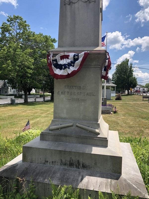
In honor of
our boys of Troy, N. H.
1917-The Great World War-1919
for liberty and humanity
Abbott, James F. • Abbott, Hollis W. • Abbott, Don • Applin, Archie W. • Awalt, Randolph C. • Bowhay, Richard E. • Bushey, Melvin S. • ★ . . . — — Map (db m151885) WM
The first bridge across this river was built approximately ¼ mile north of this location in 1785 by Col. Enoch Hale. This toll bridge, replaced in 1840, was recognized in the 18th century as one of America's outstanding bridges because of its . . . — — Map (db m85922) HM
The 513 acre Madame Sherri Forest is situated on the eastern
slope of Wantastiquet Mountain, also known as Rattlesnake
Mountain, in Chesterfield. The property abuts the larger 847
acre Wantastiquet State Forest. A 2 mile round-trip hike, the . . . — — Map (db m162556) HM
Originally constructed in 1832 by Zadoc Taft
Reconstructed in 1993 and dedicated on August 14, 1993
with the cooperation of the
citizens of Swanzey
Selectmen
Kenneth P. Colby, Jr. • Bonnie J. Tolman • Francis W. Faulkner, Jr.
Wright . . . — — Map (db m198714) HM
This church, built on the northeast corner of Cole Cemetery in 1762, was moved in sections by ox cart in 1779 to this location, then known as Federal Hill. A steeple with a bell cast by the Paul Revere Foundry was added in 1826. This edifice is . . . — — Map (db m90195) HM
A tribute to
Francis Parnell Murphy
Born in this town
August 16, 1877
Governor of New Hampshire
1937 - 1940
Donor of this memorial
in memory of his mother
Ellen Lambert Murphy
with the expressed wish
that it serve as a . . . — — Map (db m230566) HM
Here was born, on October 9, 1860
Leonard Wood
Commander of the Rough Riders
Governor of Cuba
Chief-of-Staff of the United States Army
Governor-General of the Philippines — — Map (db m230523) HM WM
Incorporated in 1753, the town of Winchester drew upon the vast forest of Mt. Pisgah, copious iron deposits, and the abundant power generated from the Ashuelot River and its tributaries to transcend its agrarian roots and become an influential and . . . — — Map (db m154898) HM
Erected by the
Town of Winchester
to commemorate the patriotic
services of these men and women
in the
World War
Adams, George W. •
★ Bailey, Harold E. •
Baker, Norman H. •
Balch, Reginald H. •
Bason, Aaron M. • . . . — — Map (db m230563) WM
Dedicated to those who responded to the call for freedom
World War II
★ Adams, George L. Jr. •
★ Adamski, Peter P. •
★ Aivalditis, Michael •
Arapage, George •
Atherton, Winston •
Austin, Louis M. •
★ . . . — — Map (db m231023) WM
Erected A.D. 1908 by the Citizens of Winchester, N.H. the Members of Post No. 19 Grand Army of the Republic Department of New Hampshire and its affiliated Womans Relief Corps In Honor of those who served on Winchesters Quota in the Army or Navy of . . . — — Map (db m154895) WM
This church occupies the site of the Town Hall and Meeting House which was destroyed by fire Sept. 12, 1909 after having been the home of the First Universalist Society for more than a century. The present edifice was built in 1912 as a memorial to . . . — — Map (db m154891) HM
Completed in 1869 for $139,500, this unique railway was built through the genius and enterprise of Herrick and Walter Aiken of Franklin and Sylvester Marsh of Campton. Over three miles long, the average grade to the 6,293-foot summit is one foot in . . . — — Map (db m77797) HM
The small man-made 'islands' in the river were used to secure a chain of boom logs which divided the Androscoggin River during the colorful and dramatic annual log drives, when the Brown Paper Company and the International Paper Company shared the . . . — — Map (db m74564) HM
On the knoll north of this site, William Sessions and his nephew, Cyrus Wheeler erected "the first building that could be honored with the name of house" in what is now Berlin, NH. Sessions helped clear many other farms in the area. In the 20th . . . — — Map (db m87972) HM
A main route to Mount
Washington was through
Crawford Notch, which
follows the Saco River to Saco
Lake-just southeast of here.
Like much of the rest of northern
New England, Crawford Notch
was part of the homeland of the
Abenaki tribe of . . . — — Map (db m162621) HM
Friends, colleagues, and admirers of executive
councilor Raymond s. Burton gathered here on
November 1, 2013, against a backdrop of the famed
Mount Washington Hotel, the path of the famous
cog railway and the majestic presidential range, . . . — — Map (db m162612) HM
Mount Washington is the highest mountain in
the northeastern United States. Part of the
Presidential Range of the White Mountains, it
was named for George Washington. It was first scaled
by Europeans in 1642. Ethan Allen Crawford and . . . — — Map (db m162616) HM
"Comfortable Quarters and a Good
Table"... accommodating visitors to the
White Mountains
The rugged mountain
tops, fearful chasms and
beautiful intervals” of the
White Mountains have beckoned
visitors since the early 1800s. . . . — — Map (db m162614) HM
This is the first engine used on this road. Weight only 4 tons. Cost but $3,000.00. Was brought here in sections through the woods by ox teams from Fabyan Place. It has carried a load of 60 persons up the mountain at once and has worn itself out . . . — — Map (db m125195) HM
The village of Zealand grew up in 1875 to serve the logging industry. Henry owned 10,000 acres in the heart of the White Mtns., with a 10-mile railroad to move logs from forest to sawmill. The village had a post office, school, store, housing, and . . . — — Map (db m74556) HM
Has been entered in the
National Register of Historic Places
by the United States Department of the Interior
Restoration of the Crawford Depot has been assisted with
a Federal Historic Preservation Fund matching grant
from the . . . — — Map (db m116631) HM
Abel Crawford and son, Ethan Allen Crawford, built the first Crawford House in 1828. It was run by Ethan's brother, Thomas, until sold in 1852. Fires in 1854 and 1859 destroyed the original inn and a replacement. Col. Cyrus Eastman erected the . . . — — Map (db m75236) HM
Mount Washington Hotel
Standing to the east, the Mount Washington Hotel was completed in 1902 as one of the largest, most modern grand hotels in the White Mountains, one of the few built in a single campaign. Designed by New York architect . . . — — Map (db m77641) HM
For whom the Notch is named, included Abel and his sons, Thomas J. and Ethan Allen. They established the first regional hotels and pioneered in opening the White Mountain area to the public. Ethan and his wife, Lucy Howe Crawford, author of an 1846 . . . — — Map (db m44299) HM
A glacial boulder overlooking Twin Mountain Village, known as "Beecher's Pulpit," since the 1870s is named for the Rev. Henry Ward Beecher. A Congregationalist clergyman, abolitionist, proponent of women's suffrage and brother to Harriet Beecher . . . — — Map (db m223419) HM
At this point you stand on the 45th parallel halfway between the Equator and the North Pole. At this point you stand also at longitude 71° 24' West from Greenwich, England. A line from this point through the center of the earth would emerge in the . . . — — Map (db m75603)
History:
• E. F. Royal built a two-story "two-store” building here after the fire of 1901.
• The north half was occupied by E.F. Royal, as a grocery, confectionery and meat market.
• A clothing store was located on the south side . . . — — Map (db m156731) HM
History:
• In earlier days, this was referred to as the Drew Block. It was built in 1890 as a two-story building. The third story was added a short time later.
• Like other store fronts in town, it has a north and south side and has housed . . . — — Map (db m157010) HM
History:
• The original building on this site was the Pitkin's Store, which burned in 1870.
• In 1886, W. E. Drew bought the rebuilt store and refitted the building. It became known as Drew & Churchill. It burned in the fire
of 1901.
• . . . — — Map (db m156942) HM
History:
• In the 1700's, a log block house sat here.
The present structure was built in 1816 and became known as Chamberlain's Tavern.
• For years this was the "center of town” and a frequent gathering place for local militia.
• . . . — — Map (db m157033) HM
Remick Building
History:
• Constructed by Gustus Remick, after the fire of 1890. He owned it until 1968. In earlier times, many promenades, meetings and walking
marathons were held on the top floor.
• It is believed this building was . . . — — Map (db m156645) HM
History:
• Believed constructed about 1868 for the Lombard family.
• Seneca Merrill later obtained the house and added the tower to the original building. Mr. Merrill was married to Viola Sutton's grandmother.
• John Pitkin Sutton was . . . — — Map (db m156668) HM
The Coos Trail was built in 1803 from Colebrook through Dixville Notch along the ancient trail of the Abnaki Indians to Erroll where it met the Coos Road of Maine completed in 1802 from Hallowell on the Kennebec River
Marked by
. . . — — Map (db m116404) HM
History
• Before 1927, Karl and Charlotte Edwards ran a grocery store from this site.
• In 1927, Sam & Susie Keach moved their restaurant, originally known as the Legion Square Restaurant, to this site. They changed the name to Legion . . . — — Map (db m156939) HM
New Hampshire has held the first-in-the-nation presidential primaries since 1920. With the first presidential "beauty contest" in 1952, our citizens have personally met the candidates and by popular ballot have declared their preference for their . . . — — Map (db m74566) HM
Here lies buried the first and only settlers of Dixville until 1865, John Whittemore and his wife Betsey.
Dixville had been granted to Colonel Timothy Dix in 1805 on the condition that thirty settlers be established here within five years. . . . — — Map (db m115640) HM
The highest wind ever observed by man was recorded here. From 1932 to 1937 the Mt. Washington Conservatory was operated in the summit stage office then occupying this site in a great storm of April 12, 1934. The crew’s instruments measured a wind . . . — — Map (db m62065) HM
The Appalachians are among the oldest mountains on Earth, reaching back more than 500 million years into time. The present chain which stretches from the Gaspe to Georgia once may have been higher than the Alps or the Rocky Mountains. Weather and . . . — — Map (db m125198) HM
Local History
The explorer Verrazano was the first European to view the White Mountains from his ship along the Atlantic coast in 1524. Darby Field was the first white man to climb Mt. Washington in 1642. The Indians called Mt. Washington . . . — — Map (db m125197) HM
The waters of the Great North Woods have long been used for travel and transportation. Local bands of Wabanaki, "People of the Dawnland," traveled the Connecticut and Upper Ammonoosuc rivers in dugout, animal skin, and bark canoes. The rivers . . . — — Map (db m151931) HM
Visit the communities of the Great North Woods to
experience the history, natural beauty, and cultural heritage of
this extraordinarily diverse and complex region.
Easily-cultivated and stone-free soils alongside
the . . . — — Map (db m162557) HM
On July 10, 1885, at 6 a.m., a slide from Cherry Mountain's northern peak left a deep gash from Owl's Head to the valley. A million tons of boulders, trees and mud loosed by a cloudburst rolled and tumbled a tortuous two miles, destroying Oscar . . . — — Map (db m77633) HM
Known as Granny Stalbird, Deborah Vicker came through Crawford Notch c.1796 as cook for Col. Joseph Whipple. It is said she brought the first bible to the north country. She married Richard Stalbird and settled on land deeded to her by Whipple in . . . — — Map (db m77632) HM
Born nearby, this inventor and scientist gained unique distinction as a pioneer aeronaut in the United States. He organized and directed a military balloon force during the Civil War and later invented a number of important and basic devices for . . . — — Map (db m77635) HM
Lancaster, founded in 1763, lies on the bed of glacial Lake Coos, formed as the glaciers receded 14,000 years ago. Today, the Connecticut, an American Heritage River, flows along the bottom of the ancient lake.
You stand at a gateway to The . . . — — Map (db m75697) HM
The house was built by Jonas Wilder in 1780 and served
as a place for town and
religious meetings as well as an inn for travelers. The Holton family later acquired
it and owned it for over a century. In 1964 the Holton family sold the house to . . . — — Map (db m140029) HM
The Lodge atop Mt. Prospect was the summer home of John Wingate Weeks (1860-1926), renowned "Father of the Eastern National Forests," author of The Weeks Act, passed by the U.S. Congress, March 1, 1911. The Act enables the government to buy . . . — — Map (db m77613) HM
This Structure, erected by Major Jonas Wilder, from boards planed and nails wrought on the site, originally possessing a four-fireplace chimney and Indian shutters, is Coos County's first two-storey dwelling. Construction was initiated on the noted . . . — — Map (db m77609) HM
Born April 22nd, 1832, mortally wounded July 2nd, 1863, while leading his command, the 1st Brigade, 1st Division, 2nd Army Corps, at the Battle of Gettysburg, Penn.
The Fighting Fifth
Raised and disciplined by Col. Cross performed . . . — — Map (db m155817) HM WM
Top Left Panel:These waters abounded in fish, as did the forests in game
As the English were pushing their settlements up the valleys of the Connecticut and the Merrimack, trappers penetrated the wilderness far above the . . . — — Map (db m158923) HM
On the site of the
Meetinghouse of the Pioneers
Erected 1784 the Town of
Lancaster builds this
monument in memory of
her citizens who served
in the wars of the Country
“Dulce et Decorum Est Pro Patria Mori”
CIVIL . . . — — Map (db m157329) HM WM
In Honor of the
Men and Women
of Lancaster
New Hampshire
Who Served in
The Armed Forces
In Time of War
( north plaque )
Honor Roll
World War I
1917 - 1918
Kenneth P. Bailey · Charles A. Balch · Chester J. Barber · . . . — — Map (db m158337) WM
John Sullivan Wells built this unique structure between 1835 and 1840.Wells brought the granite from Northumberland to construct his home. Shortly after it was completed Wells was called to Exeter to become Attorney General and the house was sold . . . — — Map (db m116640) HM
Looking NW across Israel's River you will see the remnants of the Thompson Manufacturing Company
Although manufacturing took place here for some years, highly skilled Alexander and Daniel Thompson arrived in 1865. By 1884 the company . . . — — Map (db m155843) HM
Named for Fridjof Nansen, the Greenland explorer, Berlin's first ski club formed in 1872. The club sponsored the "Big Nansen" constructed in 1936–38 by the National Youth Administration and the City of Berlin. At the time, it was possibly the . . . — — Map (db m87929) HM
The Village of North Stratford occupies the farm of William Fuller, son of Luther Fuller who was killed at Fort Ticonderoga, New York, during the War of 1812. The house of William Fuller was raided by Indians, five hundred of whom camped on the . . . — — Map (db m151897) HM
Darby Field, a New Hampshire settler, accomplished this difficult feat in 1642 from a southerly approach. Partly guided by Indians and with only primitive equipment at his disposal, he is thus alleged to be the originator of all Mount Washington . . . — — Map (db m77638) HM
This corner marks the location where the Constitution establishing the Indian Stream Republic was adopted on July 9, 1832. The Center School built here in 1828 and known as Independence Hall served as school, town hall and courthouse. The Center . . . — — Map (db m156544) HM
1917-Honor Roll-1919
Dedicated To The Men Of Pittsburg
Who Served Their Country In The World War
Aldrich, Darwin L. •
Beecher, Leo N. •
Blais, Roy L. •
Dourant, Peter R. •
Davis, Hosea B. •
Davis, Franklin H. •
Grover, Jesse A. . . . — — Map (db m156646) WM
HONOR ROLL
Dedicated To All Servicemen And Women
From Pittsburg, NH Who Have Served
Their Country Since World War II
First Tablet
Covill, Craig R. •
Grover, Brendon A. •
Howe, Larry A. •
Johnson, William A. •
Marquis, . . . — — Map (db m156682) WM
1941 1945
Honor Roll
Dedicated To Members
Of The Armed Forces
Who Served In World War II
Pittsburg, N.H.
Aldrich, Henry W. •
Audit, Joseph W. •
Baker, John T. •
Baldwin, Hollis W. •
Bernier, Roger P. •
Blais, Howard . . . — — Map (db m156683) WM
In 1832 the settlers of the area between Indian Stream and Hall's Stream, claimed by both Canada and the United States, set up the independent republic of Indian Stream. Yielding to New Hampshire in 1836, Indian Stream became part of Pittsburg and . . . — — Map (db m75611) HM
THE INDIAN STREAM REPUBLIC
Borders have always aroused intrigue and fascination. Behind closed doors are whispered well-kept secrets, and forgotten stories as well. The Indian Stream Republic is one of those stories.
The signing of the . . . — — Map (db m156549) HM
In 1876 Abel Watson and his son Laban converted their farm on this site, facing King Ravine on Mt. Adams, into a summer boarding house. Enlarged in 1884 and subsequently, the Ravine House became a key institution in opening up the northern . . . — — Map (db m77634) HM
In the spring of 1944 a high fence and four guard towers transformed a former Civilian Conservation Corps camp on this site into New Hampshire's sole World War II prisoner of war camp. Approximately 250 German and Austrian soldiers, most captured . . . — — Map (db m87928) HM
Hunter, trapper, fisherman and guide, well and favorably known by the region's early settlers, "The Lone Indian of the Magalloway" was the last survivor of a band of Abnaki inhabiting the Upper Androscoggin. Blinded by accidents, Metallak died a . . . — — Map (db m75602) HM
Honor Roll
of
Stewartstown, NH
Dedicated to those who served in
the armed forces.
World War 1,World War 2, Korea Vietnam,
Lebanon, Panama, Persian Gulf War
Operation Enduring Freedom, Operation Iraqi Freedom
names . . . — — Map (db m140470) WM
The dramatic process of conveying lumber logs and pulpwood from northern New Hampshire forests to manufacturing centers, by driving them down the Connecticut River, spanned the turn into the Twentieth Century. Hardy crews of "white-water men" . . . — — Map (db m75601) HM
These monuments
were erected by
the citizens of
Stratford, N.H. in
commemoration to
the men and women
of the area who
served their country
in the armed services
during World War II
and succeeding
wars. — — Map (db m140466) WM
The Boston, Concord & Montreal Railroad was chartered in 1844. Construction of the main line began in Concord in 1846. The tracks were completed to Laconia in 1848, to Ashland in 1849, and to Wells River, Vermont in 1853. The B. C&M RR merged with . . . — — Map (db m74567) HM
Nearby, on Pleasant Street, is the birthplace and childhood home of George Hoyt Whipple, pathologist, researcher and teacher. Dr. Whipple’s most significant research led to the development of the liver therapy for pernicious anemia. For his work, he . . . — — Map (db m74568) HM
In Memory of the Soldiers of Ashland in the War. 1861-1865. Erected by the town. G.M. Keye’s Post G.A.R. and Woman’s Relief Corps. Dedicated May 30th 1899. Town Committee: Thomas E. Greney-6th N. H. Vol’s, Frank L. Hughes-12th N. H. Vol’s, Edward P. . . . — — Map (db m65884) HM
Settled in 1766 by Jaasiel Harriman whose cabin was near the Great Rock. His nine year old daughter Mercy carried dirt in her apron to the top of this unique rock formation. Here she planted corn, pumpkins and cucumbers, making the first garden . . . — — Map (db m74569) HM
Erected in 1928, this riveted steel Warren truss span was built to replace a wooded span destroyed in the 1927 flood. This efficient truss design is based on a series of equilateral triangles with verticals added for strength. Boston Bridge Works . . . — — Map (db m75772) HM
Alderbrook developed around a sawmill built by H.C. Libbey in 1877. The Village grew to include a post office, a dozen company-owned houses, a boarding house, school and railroad station. The mill employed as many as 40 to 60 men and cut as much as . . . — — Map (db m77642) HM
This house was built in 1893 for the William O. Kelner Family who named it The Gables. Builder S.D. Morgan graced this Queen Anne style home with lavish interior woodwork to include a six panel picture window on the landing of a uniquely detailed . . . — — Map (db m116540) HM
Built in 1886 for Glessner's daughter Frances (Fanny) who
at the time was 8 years old. In Mrs. Glessner's diaries it
mentions Fanny baking, jarring jams and hosting little tea
parties. The log cabin started out by the big house and was
moved . . . — — Map (db m155143) HM
Here at the Rocks, her family's summer estate, this Chicago heiress pursued her passion for criminology in the 1940s-50s with the creation of 20 miniature dioramas depicting actual crime scenes with detailed accuracy. Called the Nutshell Studies of . . . — — Map (db m155120) HM
Built as a Congregational Church in 1877 by the founding group of eight members, the building became the Maplewood Lodge I.O.O.F. in 1940. It has also served as the Rebekah Lodge.
A beautiful three faced clock kept village residents apprised of . . . — — Map (db m116524) HM
By 1920 the adjacent road, Rt. 302 was part of the Teddy Roosevelt (TR) Trail, which ran from Maine to Oregon. It was an important way for tourists to access the White Mountains. After the 1927 floods, many bridges needed to be . . . — — Map (db m44289) HM
This house was built in 1837. I. Gardner Ramsdell sold the home to Isaac Cruft, Bethlehem business leader, for $1300.
Mr. Cruft had built and operated the Maplewood Hotel from 1865 to 1890.
He also built The Cruft Block accoss Main Street from . . . — — Map (db m116521) HM
In 1857, John Sinclair a N.H. politician built a small, but well kept 8-10 room tavern and inn.
In succeeding years, it was enlarged and enlarged again to a capacity of 350 guests.
It was the second largest hotel in the area and boasted a huge . . . — — Map (db m116520) HM
General George T. Cruft presented the Town Building to Bethlehem in 1912. A plaque in the entrance hall lists residents who served in the Civil War (87 men left home and 57 returned).
Delphin Baker, a Bethlehem resident worked to advance the . . . — — Map (db m116537) HM
Hiram W. Merrill (1822-1898) of Plymouth, N. H., built this bridge in 1870 to replace a span of 1829 that had been burned by an arsonist. The bridge employs a truss design patented by Col. Stephen Harriman Long (1784-1864) of Hopkinton, N. H. It is . . . — — Map (db m198713) HM
First known as "Broad Street," this early venture in town planning was laid out in 1788. About a mile in length and beautifully situated, starting about two miles in on next northerly road, the plan provided for an orderly arrangement of . . . — — Map (db m203377) HM
All Honor to Our
Country’s Brave Defenders
Men from Canaan
in the
Civil War 1861-1865
Abbott Charles H. • Adams Benjamin • Adams Ephraim • Adams Placid • Adams William • Aldrich Edgar D. • Aldrich Edwin D. • Atherton James W. • Barnes John . . . — — Map (db m97918) WM
Chartered in 1834 by Samuel Noyes and other Canaan citizens, it was the first-known upper-level co-ed school in the US open to African Americans. The school opened in 1835, but months later, outraged opponents used a team of oxen to drag the . . . — — Map (db m203376) HM
In times before snowplowing, winter roads were made passable by packing down snow with horse- or ox-drawn snow roller. They were used in the 19th century and early 20th century. Usually, the roller was pulled by six horses. Rolling snow made the . . . — — Map (db m203451) HM
780 entries matched your criteria. Entries 101 through 200 are listed above. ⊲ Previous 100 — Next 100 ⊳