All Gave Some… some Gave All!
To our Veterans, as protectors of this great nation, we are proud to be able to honor all servicemen and women, past and present.
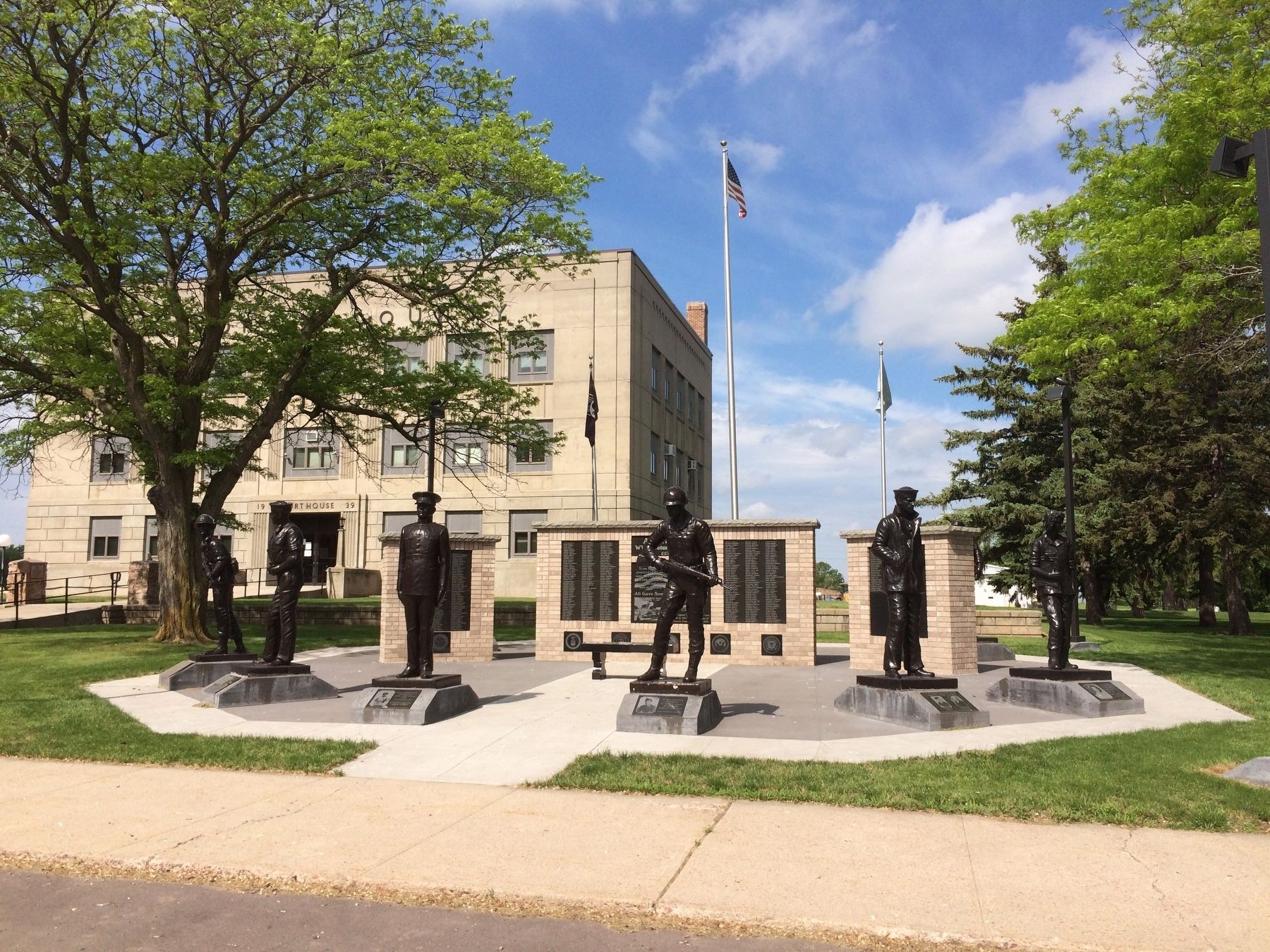
The original WWII Memorial was built in 1947 by the Veterans of Aurora County . . . — — Map (db m101728) HM
On May 24, 2012, the South Dakota DOT's Transportation Commission officially declared Interstate 90 from the Minnesota border to the Wyoming border as South Dakota's segment of the National Purple Heart Trail. The Purple Heart Trail was . . . — — Map (db m113055) HM
On Nov. 11, 1935, Explorer II, released in Black Hills, bearing Captains Orville A. Anderson and Albert W. Stevens, after a record ascent to 72,395 feet landed here, instruments intact and with a wealth of new scientific knowledge. — — Map (db m180701) HM
This is one of the 49 boxcars from the "Gratitude Train" given to the United States by a grateful French people in response to the 700 car "Friendship Train" sent to France after World War II. Each state and the District of Columbia has received . . . — — Map (db m112641) HM
Dedicated to all Beadle County Veterans Who Proudly Served
During the Vietnam War German Shepherds & Labradors were trained & used in the field. They were used to sniff out snipers, alert soldiers to trip wires & booby traps & to sniff out . . . — — Map (db m178934) WM
The Campbell Park Historic District is a residential neighborhood located immediately south of downtown.
The Campbell Park Historic District reflects the community planning and development of Huron during the late nineteenth century and the . . . — — Map (db m185450) HM
Camp SCS-4 (Huron): located on SE corner of State Fair Grounds. Companies: 2770--10/31/35-10/7/37; 4725V--10/7/37-8/15/41.
The Civilian Conservation Corps was a federal work - relief program during the Great Depression. From 1933 to 1942, . . . — — Map (db m179885) HM
Dr. Saylor moved with his family to Huron from Cogswell, North Dakota. He attended Huron schools and later graduated from St. John's Military Academy in Delafield, Wisconsin. Following his graduation, Dr. Saylor received his pre-med education at . . . — — Map (db m205746) HM
Dr. Jeffrey S. Wheeler began practicing internal medicine at Huron Regional Medical Center in October 1991 when he moved his family back to Huron. He practiced at Huron Clinic and served as medical director of the HRMC emergency room and Sunquest . . . — — Map (db m205745) HM
Dr. Karl J. Blessinger began practicing pathology at Huron Regional Medical Center when he moved to Huron in 1998 and served as medical director of both the laboratory and blood bank for 18 years.
Originally from Evansville, Indiana, Dr. . . . — — Map (db m205744) HM
Dr. Paul Hohm believed giving to others was what made life worthwhile. He dedicated his life to medicine for more than six decades and was South Dakota's senior practicing physician at the time of his passing. After graduating from Huron College, . . . — — Map (db m205747) HM
1883 - Presbyterian University of Southern Dakota was born on "Rattlesnake Hill" in Pierre SD with Rev. Thomas M. Findley as President.
1884 - College renamed Pierre university over next 14 years financial support fell below the starvation . . . — — Map (db m178926) HM
The World's Largest Pheasant spans 40 feet in length, stands 28 feet tall, and weighs 22 tons. It was dedicated on October 18, 1959. Sculptor RF Jacobs of Gooding, Idaho completed the project in 4 ½ months, costing $23,000 at that time. The . . . — — Map (db m123909) HM
This marker commemorates the service by Huron College to higher education, the Church, and the people of South Dakota, 1883 - 1984 Presbyterian Church (U.S.A.) — — Map (db m178931) HM
1908 Carnegie Library
At a meeting on March 8, 1883, the Women's Christian Temperance Union and the Young Women's Christian Association donated $38.00 to establish a reading room over Cash & Busby's Store.
In 1907, the public voted to . . . — — Map (db m185456) HM
Mamie Shields Pyle served as president S.D. Universal Franchise League 1910-1919, founding president S.D. League of Women Voters 1919. — — Map (db m205327) HM
While with the Bureau of Reclamation, Glenn Sloan saw the possibility of using mountain water from the Missouri River to develop irrigation in the James River Valley.
His vision and determination made possible the broadened multi-purpose . . . — — Map (db m123908) HM
This park was created in 2007 by leaders in the regional healthcare community. It is intended to be a place of peace and reflection, and honors those individuals whose legacy of caring left a permanent impact on the well-being of our community. . . . — — Map (db m205749) HM
Where Does the West Begin?
Traditionally the American West has begun at the edge of the settled areas, always advancing with the sun. The Delaware River was the West of 1700; the Mississippi of 1820. Then the settlement of the Pacific . . . — — Map (db m179726) HM
Wolsey: A Crossroad of the Heartland
Wolsey has been a crossroad of the heartland of South Dakota from its beginnings. In 1880 the Dakota Central Railway, a subsidiary of the Chicago & North Western, laid track following a wagon trail called . . . — — Map (db m123906) HM
Camp BF-3: located 1 mile E, 4 miles S, 1 mile W & 5 miles S
Company: 4723 May 1937-Fall 1939
The Civilian Conservation Corps was a federal relief program during 1933-1942 that gave jobless men work renovating abused lands. The Army . . . — — Map (db m137082) HM
Dedicated To All Veterans
2000
All Gave Some
Some Gave All
These Gave All
Arthur Wissman ·
Albert Burbeck ·
Henry Giedd
Lester R. Arneson ·
Kenneth Vaughters ·
Cyril Weddell
Proudly Served
Allen Benjamin F . . . — — Map (db m217666) WM
In 1880 Reverend-Doctor Harlan P. Carson, Synodical Missionary for Dakota Territory, arrived from Illinois. In 1886 he established Scotland Academy for pioneering settlers in Bon Homme and surrounding counties to support the two Christian crusades . . . — — Map (db m556) HM
South side:
First Teacher
Emma J. Bradford
Pupils
John Bradford ·
Geo. McDaniels ·
Leanna Bradford ·
Ira Brown ·
Mary McDaniels ·
Melissa Brown ·
Geo. G. Rounds ·
Delia Rounds
East side:
In 1860 near . . . — — Map (db m213909) HM
Lewis and Clark
The Lewis and Clark Expedition, officially the Corps of Discovery, was in what is now South Dakota from August 21 to October 14, 1804 and from August 21 to September 4, 1806.
While here they would make numerous . . . — — Map (db m213911) HM
In Memory of Heroes
Aase, Clifford A. ·
Adam, George S. ·
Adam, Robert J. ·
Adam, Ron D. ·
Adamson, Howard W. ·
Adamson, Shelby D. ·
Adema, Donald G. ·
Adema, James H. ·
Adema, Loren J. ·
Adema, Melvin E. ·
Adema, . . . — — Map (db m217349) WM
Dedicated to those United States servicemen who sacrificed loss of life or limb in defense of their country ....
Plaque donated by Ernest Bowyer Post 791 V.F.W. Yankton, South Dakota
Relocated from the former campus of USD/S by . . . — — Map (db m217452) WM
This museum was built by the Czech Heritage Preservation Society in 2005. Funding for the museum was provided by the Mary Chilton Chapter - National Society Daughters of the American Revolution through the Mary Chilton DAR Foundation, Sioux Falls, . . . — — Map (db m242012) HM
Tabor named for a Bohemian town of that name can well be called “The Mother City of Dakota Czechs”. Frank Bem advertised for Czechs who wanted to take up new land and a large contingent came in 1869 and by April 14, 1872, at a meeting, it was . . . — — Map (db m180970) HM
In the spring of 1873 Tabor's first schoolhouse was built. Logs were cut and hauled from the timber near the Missouri River to erect the building, measuring 18' x 24'. Josef Zitka, the first teacher, received a salary of $20 per month. There were 30 . . . — — Map (db m213814) HM
All Gave Some
Some Gave All
This memorial is dedicated to those men and women who served our country in times of war and peace so we can enjoy the freedom of democracy
Dedicated May 25, 1998 — — Map (db m213813) WM
This memorial was built with the intent to include all veterans from our area that have served our country from all branches of services and from all wars beginning with the Civil War.
American Legion
Pike-Wagner Post #2
Charter Date . . . — — Map (db m179543) WM
Home of roving Indians until 1862. The exploring party of Nicollet, scientist, and Fremont,
‘Pathfinder of the West,’ visited Oakwood Lakes July 1838, leaving the first reliable record.
The region East of the Big Sioux was ceded by the Santee . . . — — Map (db m181268) HM
Brookings: The county seat of Brookings County was platted October 3-4, 1879, when the Northwestern Railroad reached here. Some of the early store buildings were moved overland from Fountain and Medary, which soon became ghost towns. In November . . . — — Map (db m179949) HM
A memorable landmark for South Dakota State University and the city of Brookings, the Coughlin Campanile is the state’s tallest chimes tower. It was built in 1929-30.
Described in the campus newspaper as the most striking structure in South . . . — — Map (db m147593) HM
Downtown Brookings located its commercial, public, and civic buildings in proximity to the railroad depot, creating the main street. As in many towns of that era, Brookings' main street and railroad line formed a "T" shape. The Chicago and North . . . — — Map (db m213617) HM
Created 1862; Organized 1871; Convention 1877
The County, created on paper in 1862, was organized July 3, 1871 and by 1877, there were communities at Lake Hendricks, Oakwood, Lake Village and Medary, and all had delegates to the nominating . . . — — Map (db m179959) HM
Brookings County Courthouse
The Renaissance Revival-style courthouse was built in 1911 for $100,000 to replace the original 1885 two-story $7,000 wooden courthouse. Oscar Lee, an amateur artist from Volga, South Dakota, painted . . . — — Map (db m118947) HM
The Dakota Land Company of St. Paul, hoping to make this site the capital of a proposed
Dakota Territory, started a town here, naming it for Samuel Medary, Governor of Minnesota
Territory. Towns were also begun at Flandreau and Sioux Falls, the . . . — — Map (db m179957) HM
Paul Zantow, successful McPherson County farmer, was born in Germany March 23, 1883, and emigrated to America in 1902 and settled near Leola where he purchased land in 1907. He steadily increased his holdings, farming there almost to the time of his . . . — — Map (db m148215) HM
Originally owned by Jacob Olson Dahl, who was issued a land patent for eighty acres in 1884, the land that became Pioneer Park was the home of the Brookings County Fair from 1907 until 1922. The city purchased the land for $10,000 in 1923 and for a . . . — — Map (db m213618) HM
Today, a grassland mound rises above the nature park, providing a natural setting for people to enjoy. But this has not always been a pretty sight.
In 1960, the City bought this property, a former gravel pit, for the city landfill. For the . . . — — Map (db m237169) HM
These structures were part of an installation called Tangle Town at the Children's Museum of South Dakota. Artist Patrick Dougherty worked with more than 70 volunteers over a three week period to harvest willow saplings and construct this work of . . . — — Map (db m237166) HM
Legend of the Separation of the Lakes
See the narrow waterway between two peninsulas? How do you think it was formed?
A poem written by Professor A.B. Crane offers one explanation. He tells of an American Indian chief who pledged his . . . — — Map (db m179792) HM
Oakwood, called Tetonkaha, Lakes, when visited in 1838 by Nicollet & Fremont, was site of a small Fort, N of Little Round Lake in 1857 and again occupied in 1863-64. The township was surveyed by Richard F. Pettigrew in September 1871 and James . . . — — Map (db m179799) HM
The mounds found in Oakwood Lakes are typical of numerous such mounds in eastern South Dakota. Ten mounds have been located at Oakwood lakes and have been dated about A. D. 300 to A.D. 1400. Probably the remanents of late Woodland or Middle Missouri . . . — — Map (db m179695) HM
Breastworks
Probably built by two companies of the 2nd Infantry, under command of Capt. D. Davidson, in June-July, 1859. Parapets were then about 5 ft. high. A log house once stood in the center, but was razed long ago for firewood. Cannon . . . — — Map (db m179795) HM
This log cabin stands on the original site where it was constructed in 1869 by Samuel "Ol Spot" Mortimer.
Mortimer, a shoemaker from New York, came to Dakota Territory after hearing stories of the rich fur trade in the Big Sioux Valley. In . . . — — Map (db m179782) HM
Settlers arriving in the Oakwood area in the late 1870s desired a place to worship and hold prayer meetings. Lake Oakwood proved to be an ideal location for baptisms and to pitch a tent to shelter worshippers from the weather. As time and finances . . . — — Map (db m179777) HM
Millennium ago, migrating bison herds grazed the tall grass. Ducks, geese and other birds nested in the sloughs, and fish were found in abundance in the lakes and streams in this area known as the Coteau des Prairies.
With all this . . . — — Map (db m179698) HM
C. Z. Sutton came to the Oakwood Village in 1872 and in 1878 built a home on this site. It was dug into the hill so that the back and much of the sides were dirt. The front was field rock with mortar made himself by burning local limestone. The roof . . . — — Map (db m179935) HM
Each leaf on a green ash has 5 to 9 leaflets growing on 8 to 12 inch stems. During fall and winter months, clusters of seeds remain on female ash trees. Note the seed's shape. Indians were inspired to use ash wood for canoe paddles because of the . . . — — Map (db m237244) HM
The tall shrub near this post is a buckthorn. Dark green leaves, marked by prominent veins, cling to the branches long after a frost. Clusters of black, pea-sized berries appear in fall. The berries are a favorite of many birds because they cling to . . . — — Map (db m237238) HM
The cluster of oak trees at this rest spot are representative of the trees that gave Oakwood Lakes its name. In 1870, Samuel "Spot" Mortimer, sold oak trees from his land to other settlers for building their homes. Oak logs were prized for their . . . — — Map (db m237242) HM
The Oakwood Lakes chain was formed more than 10,000 years ago when melting glaciers filled depressions scooped from the earth's surface. The eight lakes, fertile lands and native woods attracted prehistoric Indians. Burial mounds in the park are . . . — — Map (db m237234) HM
There are a number of large cottonwood trees along the west shore of the island. These shallow-rooted giants are exceptionally fast growing and require lots of water. It is one of the most common trees growing along the watercourses and lakeshores . . . — — Map (db m237247) HM
At the edge of the slough behind this post you can see the reddish stems of the dogwood. Notice the white, pea-sized berries. The inner bark of dogwood was used in a mixture with tobacco and called kinnikinnick. Indians favored this in their . . . — — Map (db m237241) HM
This cluster of shrubs is comprised of gooseberries. The plant is easily recognized by the sharp, half-inch spines on its stems. Songbirds seek out the ripe berries for food. Indians used the fruit, which ripens to a deep red in the fall, to flavor . . . — — Map (db m237239) HM
Scout Island was named for the annual Boy Scout encampment once held here. The island is now a peninsula bordered on the east and south by Tetonkaha Lake and on the west by Johnson Lake.
At the flagpole is a plaque dedicated to D.C. Mackintosh, a . . . — — Map (db m237236) HM
Originally from Holland Michigan, Hessel and Charlotte Houtman married in Brookings in 1925 and farmed in various communities in Brookings County. Prior to the formation of Oakwood Lakes State Park, the Houtman family rented this land from the 1930s . . . — — Map (db m245340) HM
Here at the southeastern tip of Scout Island, exposure to wind and waves has washed soil away from the roots of trees and shrubs. The eroded soil settles to the bottom of the lake, eventually filling it in. The same thing that happens when dirt from . . . — — Map (db m237243) HM
From this vantage point, you can see the land formations described by explorer Joseph N. Nicollet and John Fremont when they camped at Oakwood Lakes in 1838. In Nicollet's words, "Wood is less scarce here. It is on all the tongues of land which . . . — — Map (db m237248) HM
Captain DeLozier Davidson and his soldiers from Fort Randall constructed this military fort in 1859. It served as a supply post for Fort Wadsworth, now called Fort Sisseton. Soldiers manned the fort, also called a breastwork, until December 1864 . . . — — Map (db m237191) HM
You are about to enter
Brookings County
home of roving Indians until 1862. The exploring party of Nicollet, scientist, and Fremont, "Pathfinder of the West," visited Oakwood Lakes, July 1838, leaving the first reliable record.
The . . . — — Map (db m181265) HM
All early maps (1838-1879) showed the Hole-in-The-Mountain or Mountain Pass where Coteau Perce creek drained SW from Lake Benton to the Big Sioux. It is 8 miles SE. Nicollet & Fremont, first explorers, visited the "Hole" on July 6, 1838 and . . . — — Map (db m177443) HM
Created with its Twin North Dakota, 2 November 1889. Its 77,047 square miles ranks 15th in size. Those square miles include: exceptional corn land in the SE, grass land in the W, wheat land in the N and productive land all over. Its lowest . . . — — Map (db m179809) HM
The region between Lake Poinsett and Oakwood Lakes was a summer hunting area for the Sioux for over one hundred years. The Sioux who frequented the area used various names for the different features in this area.
* Oakwood Lakes was . . . — — Map (db m238363) HM
The Lake Campbell Lutheran Church was originally the Medary Norwegian Evangelical Lutheran Congregation, Brookings County, Dakota Territory. The congregation was organized June 13, 1870 at the John Thompson home in Sverdrup Township Minnehaha . . . — — Map (db m179962) HM
Oakwood Lakes, called by the Sioux, Te-tonka-ha, meaning the place of the Great Summer Lodge, lie in a scenic state park 7 miles N and 3 W. First visitors of record were Nicollet & Fremont. July 8, 1838.
During the Indian Disturbances of . . . — — Map (db m179802) HM
Lake Hendricks Norwegian Colony of 1873
The first settlers at Lake Hendricks were 31 Norwegians, arriving July 14, 1873, with 11 covered wagons and 30 cattle. On May 14, 1873 they left Houston County, Minn., and Allamakee and Winneshiek . . . — — Map (db m179811) HM
Lake Hendricks State Park
This lake was named for Thomas A. Hendricks (1819-1885), Commissioner of the General Land Office, 1855-59, at which time the state boundary was surveyed and the lake named. Hendricks was a Member of Congress, 1851-55; . . . — — Map (db m184234) HM
In memory
of the
soldiers and sailors of
1861—1865.
Erected by
Robert Anderson
W.R.C. No 18.
Mustered Out
"Liberty has been bought with a great price"
"The unselfish workers of our country"
"They are beyond the . . . — — Map (db m112644) WM
(northwest section, side 1)
Day is done. Gone the sun.
From the lake. From the hills. From the sky:
All is well. Safely rest: God is nigh.
Fading light. Dims the sight.
And a star gems the sky. Gleaming bright.
From afar . . . — — Map (db m112664) HM
Albert D. Sahli is a native of Aberdeen and a 1947 graduate of Aberdeen Central High School. Coach Sahli received his bachelor's degree in 1951 and master's in 1956, both from Northern State University.
Coach Sahli's coaching career began in . . . — — Map (db m112035) HM
Dedicated to the memory of
Kent and Vera Baird
Prominent Residents of Aberdeen from 1925 - 1980
This portion of the Baird farm was donated by Roger, Virginia and Howard Baird in 2001 to the citizens of Aberdeen for their use as a park . . . — — Map (db m112670) HM
Brown County Courthouse
has been placed on the
National Register of Historic Places
By the United States
Department of the Interior
Built 1904 — — Map (db m130661) HM
Clark Swisher was a native of Vermillion, South Dakota and graduated from Vermillion High School in 1934. He want on to earn a Bachelor's Degree in 1938 from the University of South Dakota.
Coach Swisher began his coaching career at high . . . — — Map (db m112037) HM
Don Reshetar is a native of Minneapolis, Minnesota and a 1947 graduate of Minneapolis South High School. Coach Reshetar graduated with his bachelor's degree from Augustana College, in 1951 and master's degree from Northern State University in . . . — — Map (db m112036) HM
Two German-language newspapers, Dakota Freie Press (DFP) and Neue Deutsche Presse (NDP), were located a short distance from here at 524 South Main St. Owner and editor, Friedrich Wilheim Sallet, emigrated from East Prussia and published DFP for . . . — — Map (db m90571) HM
First United Methodist Church
has been placed on the
NATIONAL REGISTER
OF HISTORIC PLACES
by the United States
Department of the Interior
Built 1904 — — Map (db m131077) HM
This sculpture was commissioned by Absolutely! Aberdeen for the GROW! Campaign. It symbolizes Absolutely! Aberdeen's commitment to promote growth in and around the Aberdeen area. Each piece of the sculpture represents a specific element that we . . . — — Map (db m229636)
James Kretchman is a native of Faulkton, S.D. He first started his Northern experience as a scholar athlete in the 1950's. While playing football under Coach Clark Swisher Coach Kretchman earned Little All-American honors and he is still amongst . . . — — Map (db m112033) HM
Lyman Frank Baum was born May 15, 1856, in Chittenango, New York. He held a variety of jobs from actor to newspaper man to traveling salesman before settling in Aberdeen with his family in 1888.
Baum first opened a variety store called . . . — — Map (db m210350) HM
The Masonic Temple
Has been placed on the
National Register
Of Historic Places
By the United States
Department of the Interior
Built 1899 — — Map (db m145323) HM
1590 entries matched your criteria. The first 100 are listed above. Next 100 ⊳