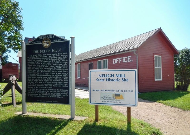
The Neligh Mills, built from locally fired brick in 1873 by John D. Neligh, was the first business and industry in the then newly platted town. Later owners and operators of the mill included William C. Galloway, Stephen F. Gilman and J. W. Spirk. . . . — — Map (db m159000) HM
The Prairie States Forestry Project was initiated by President Franklin D. Roosevelt in 1935 to combat the severe wind-caused soil erosion of the Dust Bowl days. From 1935 through 1942, the U.S. Forest Service, working with the Works Progress . . . — — Map (db m9633) HM
By the mid-1880s the Sandhills had become an important cattle-raising region. The extension of the Burlington and Missouri Railroad westward through the Sandhills in 1877-1888 made ranching more profitable by making more accessible eastern markets. . . . — — Map (db m178801) HM
West-bound travelers will leave the prairie regions of eastern Nebraska and
enter the Great Plains the next within fifty miles. This semi-arid region stretching from Canada to Mexico and westward toward the Rockies was long known
as the Great . . . — — Map (db m228360) HM
In 1888, H. D. Watson established the historic Watson Ranch, at one time containing 8,000 acres, reaching from the fertile Platte Valley on the south to the rolling hills on the north and from downtown Kearney to a point five miles west.
. . . — — Map (db m101853) HM
From 1934 to 1939, Companies 2741 and 2732 of the Civilian Conservation Corps occupied a camp near this site. Barracks housed about 200 men, ages 18 to 25, who built soil conservation dams and planted shelterbelts on nearby farms. The camp moved to . . . — — Map (db m181771) HM
(South Side)
Old block house was built by U.S. War Department on this site in 1855 to protect white colony from Indians.
Crowning achievment of the pioneers was a gold medal award for best agricultural display at World's Fair 1893 . . . — — Map (db m28077) HM
The first ranch in this area was set up on the Niobrara River about five miles south of here in 1877. E. S. Newman established his ranch to sell cattle to the government for delivery to the Indians at the Pine Ridge Agency to the north.
The . . . — — Map (db m9622) HM
On June 1, 1926, George A. Coulter completed one of the first four irrigation wells in Cheyenne County, among the earliest in western Nebraska, on his farm just south of here. He and his son, James, dug the first twenty-two feet by hand. Charles . . . — — Map (db m231142) HM
Potter began as a small Union Pacific Railroad settlement and depot midway between Kimball and Sidney. The station house was built by Union Pacific in 1870 and, as the only building in the settlement, also served as the post office and school. Its . . . — — Map (db m231144) HM
Cheyenne County was organized in 1870 from lands ceded by the Cheyenne, Arapaho, and Dakota Sioux Indians. In the panhandle of Nebraska, it is part of the Cheyenne tableland portion of the Great Plains. Some fifteen miles west of Sidney lies the . . . — — Map (db m231054) HM
In 1867 an Army tent camp was established near here to provide protection for Union Pacific Railroad construction crews. Three years later it became Fort Sidney, the nucleus for the town of Sidney, county seat of Cheyenne County. The rush to the . . . — — Map (db m231061) HM
The National Grange of the Patrons of Husbandry was organized in Washington, D.C. in 1867. During the 1870's, it was the major voice of the American farmer and its social, educational, and fraternal activities brightened farm life. "Granger Laws", . . . — — Map (db m77761) HM
This camp, constructed to house three thousand men, received the first German prisoners of war in June 1943. Most of the soldiers were members of the Afrika Korps. The prisoners were allowed to work on farms and ranches in the area and
received a . . . — — Map (db m223434) WM
Consisting of four double sets and one single
occupancy dwelling for the post commander,
these were the last officers' homes constructed
at Fort Robinson. They represent the culmination
of Victorian military architecture, with fancy
fireplaces . . . — — Map (db m223437) HM
The 100th longitudinal line west of Greenwich was the major goal set by Congress in building the first transcontinental railroad.
Construction of the Union Pacific track reached the Meridian on October 5, 1866.
To celebrate this record-breaking . . . — — Map (db m123869) HM
The southeast corner of the Nebraska panhandle was organized November 6, 1888 from a part of Cheyenne County. Deuel County has two incorporated towns, Chappell, the County Seat and Big Springs.
Before 1850 Teton Sioux Indians camped on the . . . — — Map (db m119438) HM
Organized May 3, 1873, when Perkins was still a part of Keith County. The southwest corner is the southwest corner section eighteen of township twelve, north, range forty-one of the 6th P.M.
Both the north and south Platte Rivers traverse . . . — — Map (db m119439) HM
Organized on November 8, 1887 from a part of Keith County. Consists of generally prairie land with some sand hills. Its northwest corner is the northwest corner of section nineteen, township twelve, north, range forty-one west of the 6th P.M, . . . — — Map (db m119440) HM
In May 1944 German prisoners of war from Camp Atlanta, Nebraska, were sent to a side camp near here to help area farmers complete the 1943 corn harvest. Seven farmers employed forty-four Germans, who harvested some ten thousand bushels of corn. Six . . . — — Map (db m180995) HM
The Fairmont Creamery Company was incorporated March 29, 1884, as a stock company by Wallace Wheeler and Joseph H. Rushton. This building was the original office and the creamery was half a mile east of town. From a small, part-time business, the . . . — — Map (db m78008) HM
Present Franklin County was formerly a part of the buffalo hunting range of the Pawnee Indians, whose villages were at one time located further down the valley of the Republican River. Cheyenne and Sioux hunting parties also frequented the area . . . — — Map (db m59005) HM
These rambling acres of grass and greenery might not look like a carefully planned landscape. Yet they are part of an ongoing restoration effort begun in 1939 to undo the effects of 76 years of farming, restoring agricultural fields to a diverse . . . — — Map (db m47519) HM
The fenceless plains were vast and open when early homesteaders first came here. But the very nature of homesteading - the possibility of an individual owning 160 acres - meant that somebody had to legally divide and define limits for the land. . . . — — Map (db m47577) HM
George W. Palmer built this log cabin in 1867 in Logan Township, Nebraska, some 14 miles from Beatrice. He used oak, ash, and other hardwoods cut from the banks of Bear Creek for his cabin walls. He made the brick in the gable ends by hand. . . . — — Map (db m47527) HM
Daniel Freeman
Born Preble Co. Ohio Apr. 25, 1826
Filed on First Homestead in U.S.A.
Jan. 1, 1863 and lived on it until
his death Dec. 30, 1908
Soldier, Doctor, Sheriff & Farmer
A True Pioneer. . . . — — Map (db m47585) HM
There’s a good chance you do – Homesteading reached three of every five states. Is yours among them?
The Homestead Act of 1862 offered people 160 acres of free land – if they were willing to live on it, farm it, and build a home. . . . — — Map (db m47512) HM
The Homestead Act of 1862 was one of the most significant and enduring events in the westward expansion of the United States. By granting 160 acres of free land to claimants, it allowed nearly any man or woman the chance to live the American dream. . . . — — Map (db m47619) HM
Look around you. The impact of the Homestead Act is clearly visible. Grain elevators, fertilizer plants, housing developments, state highways, modern farms – these and other features are tangible evidence of the Homestead Act’s success in . . . — — Map (db m47518) HM
Barbed wire proved invaluable for marking boundaries on the open prairie. Soon after its invention in 1874 there were over 570 different patents and thousands of variations. You can examine dozens of them on the fence nearby.
Why so many? Early . . . — — Map (db m47523) HM
You are standing on an old road trace, lined with cottonwood trees, where freight was hauled by wagon. The ability to get goods to market is yet another reason Daniel Freeman homesteaded here, four miles from the town of Beatrice.
Freight roads . . . — — Map (db m47584) HM
Here, in the middle of this restored prairie, you can imagine what homesteaders experienced when they first came to their land - listen to the birds and insects, smell cottonwood in the air, feel the richness of the soil, see the variety nature has . . . — — Map (db m47580) HM
The Homestead Act of 1862 affected millions of lives in the United States and across the world. Homestead National Monument of America exists to document and present these powerful stories of transformation.
The Homestead Heritage Center keeps . . . — — Map (db m47513) HM
What was it like to be a homesteaders? To get an idea, take a walk. The flags around the parking lot enclose an acre.
It may not seem huge. But plowing an acre meant walking about 10 miles. Over uneven soil. Driving a team of oxen. In sun or . . . — — Map (db m47514) HM
One of the worst storms in Nebraska history struck without warning on Easter Sunday, April 13, 1873. Rain began to fall in the afternoon and evening, later changing to snow. By Monday morning heavy, wet snow, driven before howling northwesterly . . . — — Map (db m181900) HM
The North Loup Project was authorized as a multi-purpose flood control and irrigation project by the Flood Control Act of 1944. The Twin Loups Reclamation District, organized in January 1954, and The Twin Loups Irrigation District, organized in . . . — — Map (db m189376) HM
During the 1930’s, Nebraska suffered one of the most serious droughts in its recorded history. In all parts of Nebraska rainfall was far below normal. In 1936, corn yielded only 1/10 as much per acre as it had during the years 1923-1932. The dry . . . — — Map (db m206748) HM
In January 1944 German prisoners of war from the Indianola camp came to a side camp here to help area farmers complete the 1943 corn harvest. Over the next two years the Palisade camp was activated and deactivated as needed to supply labor to . . . — — Map (db m176961) HM
The Irish were a major immigrant group contributing to the settlement of Nebraska. Speaking the English language, they blended into the population and were found in many communities. However, due to ancient animosities with Britain, some of them . . . — — Map (db m179200) HM
The Grand Island and Wyoming Central branch of the Burlington railroad came through this area in 1887 and built a siding here named Mullen after a railroad contractor. In 1888 Trefren and Gandy platted the village of Mullen. Hooker County, named . . . — — Map (db m178920) HM
Frank Zybach, farming near Strasburg, Colorado, patented a "Self-Propelled Sprinkling Irrigating Apparatus” on July 22, 1952. Mobile towers carried a pipeline in a circle around a pivot. Sprinklers on the pipeline distributed the water. In 1954, . . . — — Map (db m147176) HM
The Burlington & Missouri River Railroad entered Nebraska at Plattsmouth in 1870 and built west to join the Union Pacific at Kearney Junction (now Kearney city) on September 3, 1872. The railroad bridge into Kearney was used for 104 years. It . . . — — Map (db m58980) HM
One of the earliest cowboys of the many who rode the long trail north from Texas to Ogallala behind a herd of longhorns. Sanders first arrived here about 1869. He rode for William Paxton during the turbulent open range period of Western Nebraska. He . . . — — Map (db m51225) HM
Before you is a settlement success story resulting from the Homestead Act of 1862 and the Timber Culture Act of 1873.
David A. and Kate E. (Blakely) Clopton came to Keya Paha county from Jefferson, Iowa in 1884. They homesteaded just south of . . . — — Map (db m237138) HM
In 1910 the Kimball Irrigation District voted to construct an irrigation system with a reservoir and two canals. The rough topography traversed by the canals required several aqueducts, which used flumes manufactured in Kimball, Nebraska, by . . . — — Map (db m178497) HM
maN zhaN (the land) is xube' (sacred) to the Ponca People as is Ni' (water). Following forced removal of the Ponca Tribe to Oklahoma, the tribe split into two groups. The members that stayed in Oklahoma are now referred to . . . — — Map (db m192657) HM
The son of a Kentucky frontiersman, Lincoln had to struggle for a living and for learning. Five months before receiving his party's nomination for President, he sketched his life:
"I was born February 12, 1809, in Hardin County, Kentucky. My . . . — — Map (db m179399) HM
The Institute of Agriculture and Natural Resources fulfills the land-grant university mission of the University of Nebraska as mandated by the Morrill Act of 1862 by offering academic degrees through the College of Agricultural Sciences and . . . — — Map (db m66846) HM
This area dedicated to the memory of…
Beloved friend, teacher, dairy products judge and coach, creator of Husker Cheese and a pioneer of the Nebraska Dairy Industry. — — Map (db m66847) HM
The "Haymarket" name can be traced to Lincoln’s first decade. In the capital city’s original plat of 1867, a "market square" was identified, bounded by O and P, 9th and 10th streets. It served as an open-air market for produce and livestock, as well . . . — — Map (db m159097) HM
This capstan was used when marshy ground made direct pulling with oxen impossible. A cable was unwound from the spool in the center of the capstan and attached to the ditch plow. Teams of oxen or draft horses were hitched to the wooden arm of the . . . — — Map (db m191897) HM
Cody, Frank and Luther North were for a time partners in a ranch located along the Dismal River in Nebraska.
This cabin was their headquarters. The cabin was moved from its original location to the Bratt Ranch in 1882.
Nate Trego later . . . — — Map (db m125054) HM
This "crab" is a reproduction of the original used with the ditch plow. It was pulled into the ground as a wedge and a cable was run through a pulley in its center and back to the plow. Using block & tackle and the crab as an anchor, the oxen pulled . . . — — Map (db m191884) HM
This giant plow was used to dig drainage ditches along the Nemaha River in eastern Nebraska, the Platte River here in Lincoln County, the Medicine Creek south of here in Frontier County, near Big Springs, Nebraska, and in Colorado and Wyoming. . . . — — Map (db m191851) HM
The Pawnee were one of the most important Native American tribes of the Plains area. By the late eighteenth and early nineteenth centuries they were living in circular earthlodges in large villages, sometimes including more than a thousand people. . . . — — Map (db m191940) HM
You are standing in front of a typical scene found in most farmyards in Lincoln County. A windmill and cistern were vital to the survival of both humans and livestock, especially during the hot, dry Nebraska summers. The windmill allowed farmers and . . . — — Map (db m191774) HM
In 1908 John Harrop, originally from Roca, Nebraska, filed a homestead claim just west of the
Calamus River about thirteen miles north of Taylor in Loup County. Harrop acquired 640 acres
under the Kinkaid Act of 1904, which had been passed to . . . — — Map (db m77919) HM
[side 1] Built in 1906 and remodeled in 1923, this was the home of cattleman Heber Hord until his death in 1949. Hord was the only son of Thomas Benton (T.B.) Hord, who founded a livestock feeding company based in Central City. T.B. Hord . . . — — Map (db m181600) HM
This was Pawnee Country, the last Nebraska home of an Indian Confederacy which once numbered more than 10,000, consisting of four tribes — Skidi, Grand, Republican and Tapage. Their domain covered a large part of Central Nebraska where they lived in . . . — — Map (db m179389) HM
"The large one-bottom plow cuts a furrow 4 feet wide, 2 feet deep. The "turning under" moldboard is 6 feet high and 6 feet wide. The "landside" is 10 feet long and one foot high. The plow is "foundry" made and was strengthened and mended. The plow . . . — — Map (db m194897) HM
This "ELI" Windmill was the brand name of windmills produced by the Kregel Windmill Factory of Nebraska City. Established in 1879, by George F. Kregel, the factory produced windmills up until World War II. Due to materials rationing for the war . . . — — Map (db m66213) HM
This mural celebrates
100 Years
Time proceeds from top to bottom
Past is dim so colors are more soft and grows intens[e] at the bottom Today
The seasons are from left to right
Restored 1993 + 2011
Mural 12' high . . . — — Map (db m66892) HM
This area of the Little Nemaha Valley was settled in the late 1850's and early 1860's. Many settlers were Northern European immigrants. By 1881, the Missouri Pacific R.R. had begun constructing its Kansas City-Omaha line through the area. The . . . — — Map (db m182086) HM
The jail was originally located just northeast of its current location. For a number of years, a local farmer used it as a grain bin. In 1977, it was moved back to the village and placed adjacent to the Steinauer Community Heritage House. — — Map (db m190301) HM
Named for the beautiful, spirited wild horses so numerous in this area when white men first visited this lush plains, this Spring symbolized the hope and faith its discovery brought to the early pioneers. Though the rich land beckoned them, men . . . — — Map (db m79379) HM
Through this valley passed the Oregon Trail, highway for early explorers, fur traders, California-bound gold seekers, freighters, and brave pioneers seeking new homes in the West. Traffic was especially heavy from 1843 to 1866. At times as many as . . . — — Map (db m45521) HM
Due to the generosity of Mrs. Albert Gehner, Mr. Theodore Friedhof, and many other benefactors, this site has become a focal point of agricultural activity in Platte County.
The donation of this land, formerly known as the Browner Farm, and a . . . — — Map (db m122883) HM
Leo Sokol
Leo Sokol invented and began manufacturing irrigation pumps in 1933 in Duncan. Leo invented the first hydraulic single-cylinder Duncan manure loader. He was a natural inventor who created many other products for the agriculture . . . — — Map (db m58747) HM
Born in 1894, Frank Zybach grew up in Loup Township, Platte County, Nebraska. He began inventing at age 13. In 1948, he developed a prototype of a self-propelled sprinkler irrigation machine. In 1952, the “Zybach Self-Propelled Sprinkling . . . — — Map (db m181698) HM
During the 1950s and 1960s Paul Zimmerer, working in his auto and farm equipment repair shop in Lindsay, Nebraska, invented a series of irrigation products that changed the landscape of Nebraska agriculture. One was the tractor-towed “Towline” that . . . — — Map (db m181350) HM
Welcome to Spring Valley Park. Pioneers of this
region, eastern Rock County, recognized it as a great
natural haying region extending over twenty miles
south down this valley. The nearby village of Newport.
established in 1883, became one of . . . — — Map (db m223476) HM
Pioneers saw the Great Plains as an endless and monotonous "Sea of Grass," but it was much more. It was a land inhabited by nomadic people who followed the immense herds of bison. These Native American tribes knew and understood the prairie, its . . . — — Map (db m191415) HM
”For more than a century, the Platte River provided a natural path for pioneers traveling West, a water source for herds of bison and a harvesting region for fur trappers. Even today, the river’s impact is enormous; it is the single largest source . . . — — Map (db m191406) HM
This landmark is dedicated to Mr. Pascual Huerta and the men who helped build this stone building during the 1930’s. Mr. Huerta and his German Sheperd walked daily from near Stegall, Nebraska to Scottsbluff, gathering stones along the way. Mr. . . . — — Map (db m238879) HM
This millstone is believed to be from the gristmill built by William Smith in 1871 on the Big Blue River south of Beaver Crossing. W. J. Thompson took over the mill in 1873, and it continued to operate until about 1917.
Gristmills were an . . . — — Map (db m76747) HM
Since 1868, Seward has, with but few interruptions, sponsored a yearly 4th of July celebration which has gained national attention. This square, the original site of the festival, is today its focal point. Special trains once brought revelers here . . . — — Map (db m101843) HM
For a few years, the Antioch vicinity was one of the most important potash-producing regions in the nation. Antioch grew from a small village to a town of about 2,000. When the First World War broke out, the United States was cut off from European . . . — — Map (db m178812) HM
Twenty miles northeast of here is Spade Ranch headquarters, a National Register of Historic Places site. In Ellsworth are the business offices (built c. 1890) and home (built 1902) of cattleman Bartlett Richards (1862-1911), a Vermont native. . . . — — Map (db m180899) HM
During the Depression low farm prices, accompanied by dust storms and drought, created unrest among farmers and workers in Sherman County and across Nebraska. The Farm Holiday movement, which encouraged farmers to withhold agricultural products . . . — — Map (db m181102) HM
America's prairies
experienced dramatic change
when thousands of families
migrated west, encouraged by
a series of "Homestead Acts."
These acts required prospective
owners to manage their lands based on farming
and grazing practices in . . . — — Map (db m174962) HM
Large pioneer ranches were established in this region of Nebraska in the 1870's and early 1880's. Charles F. Coffee was one of these pioneers, with ranch headquarters on Hat Creek in Nebraska and Rawhide Creek in Wyoming. By June, 1886, the Fremont, . . . — — Map (db m9584) HM
This sod house is a replica of one built at this site by Kenneth Pelren and Segard
Anderson in 1930. Clay soil held together by a tenacious root system was plowed from the prairie and stacked in a manner similar to modern brick construction. . . . — — Map (db m185043) HM
A railroad camp named Summit (elev. 4876 ft.) was located on this site in 1884. When the Fremont, Elkhorn, and Missouri Valley Railroad reached here in 1886, an unincorporated townsite named Bowen was platted and designated the county seat of Sioux . . . — — Map (db m9593) HM
Named for Secretary of War Edwin M. Stanton in 1862. Jacob Hoffman and Francis Scott filed the first homestead applications in the county on November 18, 1865. The first farms, however, were those of Charles and Mitchell Sharp, who homesteaded near . . . — — Map (db m179371) HM
Bruning Army Air Field, located northeast of here, was one of eleven army airfields in Nebraska during World War II. Construction began in September 1942 on 1,480 acres of farmland, for which the government paid twelve landowners $73,400. The field . . . — — Map (db m206989) HM
The Civilian Conservation Corps (CCC) was authorized by Congress in 1933 to provide employment and vocational training to young men during the Great Depression. The CCC worked on forestry and soil conservation projects across the nation. Company . . . — — Map (db m79890) HM
You are near the center of one of the world’s greatest cattle producing areas — some 13 million acres of deep sands with a high water-table exposed in numerous lakes. This great sea of sand was deposited by winds of a desert climate that ended . . . — — Map (db m180889) HM
The Sandhills, Nebraska’s most unique physiographic feature, covers about one-fourth of the state. The sandy soil acts like a giant sponge, soaking up rain and forming a vast underground reservoir. Hundreds of permanent lakes are found here. . . . — — Map (db m180875) HM
After 1861 an important variant of the overland trails system, the Nebraska City – Fort Kearny Cutoff, passed nearby, over which freight was transported from the Missouri River to western forts and mining camps.
The region’s first . . . — — Map (db m101842) HM
Between 1855 and 1867 companies like Russell, Majors, and Waddell shipped millions of pounds of freight across the plains to supply military posts and mining camps to the West. After 1861 freighters followed the "Nebraska City-Fort Kearney . . . — — Map (db m223482) HM
In 1898 E. C. Bishop, a teacher in nearby Bradshaw, organized student clubs. Through these clubs he planned his school lessons so that they related to the students’ activities on the farm and in the home. The first projects Bishop assigned dealt . . . — — Map (db m181319) HM