By Cosmos Mariner, August 17, 2014
The Neligh Mills Marker
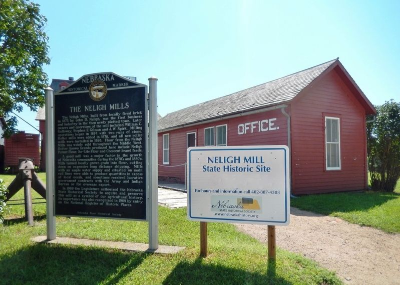
| On East 2nd Street at N Street, on the left when traveling west on East 2nd Street. |
| On 513 Avenue, 1.4 miles north of Orchard, on the left when traveling north. Reported permanently removed. |
| On Box Butte Avenue just south of West 18th Street, on the right when traveling south. |
| On Interstate 80 at milepost 271, on the right when traveling west. |
| On U.S. 30 at 1733 Road, on the right when traveling east on U.S. 30. |
| On State Highway 2, 1 mile east of Ravenna Road (State Highway 68), on the right when traveling east. |
| On U.S. 75, 0 miles north of O Street, on the right when traveling north. |
| On U.S. 20, on the right when traveling east. |
| On Main Street (Lincoln Highway) (U.S. 30) at Road 79, on the right when traveling east on Main Street (Lincoln Highway). |
| On Front Street at Elm Street, on the left when traveling west on Front Street. |
| Near Interstate 80 (at milepost 61), 1.3 miles east of Upland Parkway (Alternate Interstate 80), on the right when traveling west. |
| Near Interstate 80 (at milepost 61), 1.3 miles east of Upland Parkway (Alternate Interstate 80), on the right when traveling west. |
| On State Highway 2 at milepost 273, on the right when traveling east. |
| Near Bridges to Buttes Byway (U.S. 20) 1.3 miles west of 1st Street, on the left when traveling west. |
| Near Bridges to Buttes Byway (U.S. 20) just south of Soldier Creek Road, on the right when traveling west. |
| On U.S. 30 at North Meridian Avenue, on the right when traveling east on U.S. 30. |
| On County Highway 36 at County Highway 63.2, on the left when traveling south on County Highway 36. |
| On County Highway 36 at County Highway 63.2, on the left when traveling south on County Highway 36. |
| On County Highway 36 at County Highway 63.2, on the left when traveling south on County Highway 36. |
| On State Highway 61, 8.5 miles north of U.S. 34, on the right when traveling north. |
| On Fairmont Avenue at F Street, on the left when traveling south on Fairmont Avenue. |
| On 15th Avenue at N Street, on the left when traveling north on 15th Avenue. |
| On Court Street (U.S. 136) at 2nd Street, on the right when traveling west on Court Street. |
| On State Highway 91/11, 0.3 miles east of Windy Hill Road, on the right when traveling east. |
| Near Dam Road (State Highway 96) 7 miles north of State Highway 91, on the left when traveling north. |
| Near Q Street (US HWY 34) (Alternate Interstate 80) at 12th Street, on the right when traveling west. |
| On North Main Street (Nebraska Route 25A) north of East Carrigan Street, on the right when traveling north. |
| On North 4th Street at East Clay Street, on the right when traveling north on North 4th Street. |
| On Northwest 1st Street west of North Cleveland Avenue, on the left when traveling west. |
| Near North Street (U.S. 6) just east of Brown Avenue (State Highway 10), on the left when traveling east. |
| On Harold Warp Memorial Drive (32nd Road) (State Highway 10) near State Highway 50A, on the right when traveling south. |
| On West 1st Street (U.S. 30) at West O Street on West 1st Street. |
| On US 183 (U.S. 183) 2.1 miles south of NE 12 (Nebraska Route 12), on the left when traveling south. |
| On Lincoln Highway (U.S. 30) just west of County Road 29, on the right when traveling east. |
| Near 521st Avenue at 890th Road, on the left when traveling north. |
| Near 521st Avenue at 890th Road, on the left when traveling north. |
| On Pine Lake Road near South 30th Street. |
| On East Campus Loop, on the right when traveling west on East Campus Loop. |
| Near North 7th Street at P Street, on the right when traveling south. |
| Near North Buffalo Bill Avenue, 0.8 miles north of Lincoln Highway (U.S. 30), on the right when traveling north. |
| Near Scouts Rest Ranch Road (State Highway 56E) 0.2 miles west of North Buffalo Bill Avenue, on the right when traveling west. |
| Near North Buffalo Bill Avenue, 0.8 miles north of Lincoln Highway (U.S. 30), on the right when traveling north. |
| Near North Buffalo Bill Avenue, 0.8 miles north of Lincoln Highway (U.S. 30), on the right when traveling north. |
| Near North Buffalo Bill Avenue, 0.8 miles north of Lincoln Highway (U.S. 30), on the right when traveling north. |
| Near North Buffalo Bill Avenue, 0.8 miles north of Lincoln Highway (U.S. 30), on the right when traveling north. |
| On U.S. 183, on the right when traveling north. |
| On 16th Street (Lincoln Highway) (U.S. 30) at 15th Avenue, on the left when traveling east on 16th Street (Lincoln Highway). |
| Near South Park Street (State Highway 39) just south of Ewing Avenue, on the right when traveling south. |
| Near South 1st Street just south of U.S. 136, on the right when traveling south. |
| On Central Avenue east of 15th Street, on the left when traveling west. |
| On Midland Street at 5th Street, on the left when traveling south on Midland Street. |
| On Market Street south of 3rd Street, on the right when traveling south. |
| On 2nd Street just east of Main Street, on the right when traveling east. |
| On State Highway 61, on the left when traveling north. |
| On U.S. 183, 0.3 miles south of Interstate 80, on the left when traveling south. |
| Near 15th Street east of 10th Avenue, on the left when traveling east. |
| On 13th Street (Business U.S. 30) near 27th Avenue, on the left when traveling east. |
| On 28th Street just east of Linden Drive, on the right when traveling east. |
| On Pine Street just north of 1st Street, on the left when traveling north. |
| On U.S. 20, 0.1 miles east of 457th Avenue, on the right when traveling east. |
| Near Old Oregon Trail (Old State Highway 92) 1.8 miles west of Five Rocks Road, on the right when traveling west. |
| Near M Street just west of 10th Street, on the right when traveling west. |
| On East 27th Street just east of Broadway, on the right when traveling east. |
| On U.S. 34 at South 6th Street, on the left when traveling east on U.S. 34. |
| On 1st Street (State Highway 2) 0.3 miles west of 396 Trail, on the right when traveling west. |
| On Mari Sandoz Sandhills Trail (State Highway 27) just north of State Highway 2, on the left when traveling north. |
| On O Street at North 7th Street, on the right when traveling west on O Street. |
| Near Forest Road 902, 1.5 miles west of Toadstool Road, on the right when traveling west. |
| On U.S. 20 at milepost 1,, 1 mile east of the Nebraska/Wyoming State Line, on the right when traveling east. |
| Near Forest Road 902, 1.4 miles south of Toadstool Road, on the right when traveling west. |
| On US 20 (U.S. 20 at milepost 9) at Kate Street, on the right when traveling east on US 20. |
| On North Main Street just south of East 2nd Street, on the left when traveling south. |
| On State Highway 4, 6.8 miles east of U.S. 81, on the left when traveling east. |
| On Holdredge Avenue west of South Avenue, on the left when traveling west. |
| On Mercure Loop (State Highway 2) at U.S. 83 on Mercure Loop. |
| On Mercure Loop (State Highway 2) at U.S. 83 on Mercure Loop. |
| On Lincoln Street, 0.1 miles south of West Jackson Street, on the right when traveling south. |
| On State Highway 93A at Local Road 11, on the right when traveling north on State Highway 93A. |
| Near North Nebraska Avenue at 4-H Drive, on the right when traveling north. |