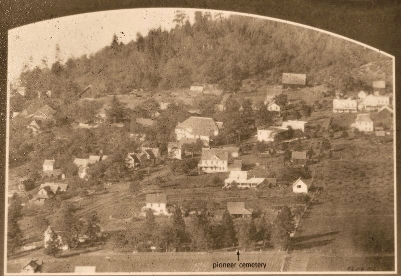
1882 • Earliest burial.
1897 • A.H. and Jennie Jewett deed the property to the Board of School Directors of District #19.
1914 • Property deeded to City of White Salmon.
1922 • Last burial.
1955 • Property converted . . . — — Map (db m129499) HM
This pioneer town founded in 1853 on the donation claim of Louis H. Davis, once was the county seat and an important stop-off for travelers between the Columbia River and Puget Sound. The sturdy little church, built in 1858 with hand-forged nails . . . — — Map (db m129165) HM
Under the provisions of the National Historic Preservation Act of October 15, 1966, this property possesses exceptional value in commemorating, or illustrating American History Placed on the National Register on April 24, 1973 by the National Park . . . — — Map (db m129172) HM
The Oregon Trail, stretching from Missouri to the Pacific, served as the most important route for settlers traveling west. As many as 1600 wagons a day rumbled over the famous route. The northwestern most extension of the Oregon Trail was the . . . — — Map (db m129173) HM
It used to be that you could throw a stick near the headwaters of the Cowlitz River beyond Packwood and it would float past here, to the Columbia River, eventually ending in the Pacific Ocean. Native Americans and pioneers alike not only used the . . . — — Map (db m158980) HM
The community of Mossyrock sits on the eastern edge of the Klickitat Prairie. The prairie, named after the Klickitat Indians, was actually home to the Taidnapam, or Upper Cowlitz Indians. Both spoke a dialect of Sahaptin. Early settlers often . . . — — Map (db m158981) HM
Richard G. Sidley Territorial Police and Customs Collector settled here in 1889. He started an international town, general store, saloon, livery barn, and black smith’s shop. He served as postmaster and kept an eye out for horse thieves. Dominion . . . — — Map (db m154992) HM
Founded by the Molsons of Montreal, Quebec, as a mining and townsite venture, it boomed in 1900 - died in 1901. Homesteaders came, then the railroad came in 1905. Molson built up again to become the commercial center of the Okanogan Highlands - . . . — — Map (db m154989) HM
Before 1900, the cattlemen had the rangeland to themselves, except for wild horses. Then sheep appeared. Tempers flared instantly. Haystacks put up by sheepmen mysteriously burned. The hostility reached its climax one night in the spring of 1903 . . . — — Map (db m154939) HM
Welcome, folks, to Old Molson, founded in 1900. She was a lively mining camp until a farmer claimed the whole town as part of his homestead. While the dispute raged, disgusted citizens founded New Molson half-a-mile north. People, businesses, the . . . — — Map (db m154982) HM
In 1906, 40 acres were set aside for a townsite. A one-room schoolhouse and quarters for a teacher were built. The railroad maintained a crew bunkhouse and quarters for the section foreman’s families. Trains stopped here 20 min. - 1/2 hr. to cool . . . — — Map (db m155004) HM
In 1886, shortly after their arrival, Lee Ives and his wife Rena built two log cabins near the river bank and started taking in travelers. Their cabins were located very near this spot in what was to become Pateros.
Lee Ives built the Ive's . . . — — Map (db m129012) HM
The first to settle in the area were the Methow Indians. Although they moved frequently in summer to take advantage of various foods (berries, deer and roots), they usually wintered less than one mile from the mouth of the Methow River.
The . . . — — Map (db m128998) HM
Below this sign you can see the remnants of the China Ditch built by Chinese miners sometime between 1860 and 1880. This ditch carried water from a diversion point three miles up the Methow River to sluice gold from the Columbia River sandbars a . . . — — Map (db m128997) HM
The head of navigation on the Okanogan River during steamboat days until 1914 when the railroad came. The shrill sound of the boat whistle to open the drawbridge, rattle of freight wagons and ringing of freight bells which served the north half of . . . — — Map (db m207934) HM
In 1886 Wellington French immigrated from Quebec Canada to the Okanagan Valley and homesteaded this ranch on Scotch Creek. He married Mary McCaskill on Nov. 11 1889 in Spokane. She bore four children: Eva, Katie, Robert and Ray, all of whom grew up . . . — — Map (db m207932) HM
Here at the forks of the rushing Methow, Boston-bred Guy Waring founded Winthrop in 1891. Trappers, prospectors and homesteaders tramped into his frontier store. In '95 Colonel Thomas Hart came through to carve a narrow-gauge wagon road across the . . . — — Map (db m36497) HM
A Collision of Cultures
First they came by sea and then by land - the Euro-American presence swelled through the region. The newcomers brought strange illnesses, like smallpox and malaria, and unwittingly spread plagues of death to the . . . — — Map (db m177402) HM
This place — where river meets ocean – is one of many stories. The Chinook people lived here at Qiqayaqilxam, or Middle Village, for countless generations. Qiqayaqilxam is one of several villages that stretched from Cape Disappointment to Pillar . . . — — Map (db m177411) HM
On the hill behind is the grave of Willie Keil, nineteen year old son of Dr. William Keil, leader of the Bethel Colony that came west to settle here in November, 1855.
Willie was to have driven the leading team in the wagon train which was to . . . — — Map (db m129100) HM
The Elbe Lutheran congregation was founded in 1893 by settlers from Germany. For the first 13 years, services were held in members' homes and the town hall.
Elbe Evangelische Lutherische Kirche was built in 1906. The building's dimensions are 18 . . . — — Map (db m129483) HM
"Memory Vessel" was commissioned by the City to honor the Scandinavian heritage of families that influenced early development at the head of the bay. The artwork references the bond between the Scandinavian cultures and the sea. The vessel . . . — — Map (db m179836) HM
The newly built Memorial Presbyterian Church was dedicated on September 13, 1913, under the leadership of Reverend Thomas J. Weekes. Since 1893, Rev. Weekes had been teaching and preaching on the Peninsula. The site for the church was donated by . . . — — Map (db m180044) HM
The settlement of Gig Harbor by white people actually began on the east side of the harbor. Samuel Jerisich arrived in Gig Harbor in 1867 and built a small cabin on the east side of the bay near the sandpit. Later, the Jerisich family moved to . . . — — Map (db m179983) HM
In 1867, Sam Jerisich, Peter Goldsmith, and John Farrague were fishing in Puget Sound when bad weather prompted them to seek shelter in Gig Harbor. They liked what they saw and decided to make it their home, becoming the first three white people . . . — — Map (db m179977) HM
This corner is rich in local history. When the first white men settled in Gig Harbor, they shared the bay with the Native American people who lived in a village on this corner. In the mid 1880s, the Indians permitted the use of one of their . . . — — Map (db m179889) HM
Andrew and Bertha Skansie purchased this property just after the turn of the century, first building a cabin on the beach. In 1910 they constructed the brick home. Andrew was a young but accomplished stone mason, bringing the skill from Croatia . . . — — Map (db m179984) HM
The head of the bay business district included a post office, livery stable, general store, and real estate office. Around 1907, Swedish Captain Axel Uddenberg built his home and opened a meat market near this site. "Front Street", now . . . — — Map (db m179837) HM
This building is dedicated to the Sehmel Family,
pioneers of the Gig Harbor Peninsula
[photo of the Sehmel house]
W.L.C. Henry Sehmel homesteaded in the Rosedale area in 1884. In 1887, Henry married Dora Gummert. Dora made her way to . . . — — Map (db m179887) HM
Front of Marker:
Monument Expedition
Camp One
29 Jan 1906
Left Side of Marker:
This stone is donated by
Gregory L. Meeker
Cousin to Ezra
In honor of Bobby and Helen Meeker who taught their son the love of . . . — — Map (db m39786) HM
For hundreds of years, South Hill has been at the crossroad of some of our nation's most fundamental changes. The South Hill Heritage Corridor traces four historic trade routes the stories of which, contributed to the rich history of our state. . . . — — Map (db m197184) HM
First School Session North of Columbia (River) -1854
Refuge During Indian War 1855-56
Occupied by families of Rev. J.F. Devore 1853
Abram Woolery 1854
Sherwood Bonney 1854-1856 — — Map (db m28031) HM
One person can build a log cabin with very few tools. Carr felled the trees
surrounding his home site. Notched ends fit together, with quartered saplings
to fill the gaps between the logs. Cedar shingles covered the roof. The front porch
and rear . . . — — Map (db m157829) HM
Family and community life were always a part of the Tacoma City settlement.
Residents contributed funds for a school building in 1869. J.P Stewart was the
first teacher for thirteen students. In 1873, mill workers built St. Peter's Church . . . — — Map (db m157747) HM
Job Carr, a recently discharged Union war veteran, came to Commencement Bay in 1864. In the
winter of 1864-65 he began clearing
land for a small log cabin near today's
North 30th and McCarver in an area
now called Old Town Tacoma. By . . . — — Map (db m157618) HM
For thousands of years, S'Puyalupubsh (Puyallup) Indian fisherman camped at this site to fish, dig clams, and preserve their catch. They also rested here to await the changing tide before traveling through the Tacoma Narrows. They called
this . . . — — Map (db m157749) HM
You are standing in the middle of Tacoma City. Morton McCarver laid out the
town in 1869. At that time forests covered the area, but were soon logged by
the Hanson, Akerson mill, located down the hill from this site. There were enough
people . . . — — Map (db m157827) HM
Job Carr and Rebecca Pittman were married in 1840 in Richmond, Indiana where
they raised four children; Anthony, Howard, Marietta, and Margaret. Job, a
Quaker, enlisted in the Civil War at the age of 48 and after three years he was
discharged. In . . . — — Map (db m157745) HM
Morton Matthew McCarver General Iowa and Oregon Militias Born in Madison County, Kentucky, January 14, 1807 Died at Tacoma, Washington, April 17, 1875 Pioneer and founder of Burlington, Iowa – 1883 · Linnton, Oregon – 1843 · Tacoma, Washington . . . — — Map (db m221083) HM
Wife of City of Anacortes founder,
Amos Bowman
Lisa Liedgren, Artist
Mural based on image courtesy of Anacortes Museum
(Wallie Funk Collection - 1890) — — Map (db m74001) HM
Built in 1869 on the North Fork of the
Skagit River. Anderson was one of first settlers in Skagit county. He felled and squared the
logs using hand tools. He rowed to Utsalady for
planed lumber. This cabin was moved to La Conner
in 1952 by The . . . — — Map (db m177968) HM
Indians Had Canoes Of Many Kinds On Skagit Waters
The old-time Indian canoe builders with their crude tools were master craftsmen turning out everything from these utilitarian shovel-nosed Skagit River canoes for poling up stream and . . . — — Map (db m178086) HM
(above photo) La Conner 1873: The first trading post on the Swinomish flats was established in 1867 upon the present site of the Town of La Conner by Alonzo Low.
Thomas Hayes was the next Swinomish trader of record. He arrived shortly after . . . — — Map (db m177974) HM
From Dick Fallis, Historian, Skagit County Pioneer Association
Jasper Gates was born April 9, 1840, in Adair County, Missouri. He grew to manhood at the family farm there, married Clarinda Kimble in 1860, served in the Union Army during the . . . — — Map (db m75484) HM
George Stevenson stood on the north bank of the Columbia River, listening to it roar through this narrow Gorge, and envisioned a community strategically located for commerce. Every person traveling this liquid highway stopped here above the Cascades . . . — — Map (db m158175) HM
Indian name Doksk Ad
First white settlers 1853.
1855 the bark Anandyr sailed
first cargo ship spars to the
French shipyards at Brest.
Saw mill began operation 1857.
First lumber export to Shanghai 1860. By 1870 there were
54 houses and 147 . . . — — Map (db m141229) HM
The first Presbyterian Church of Everett meets here. It was established in February 1892.
In 1897 the wood frame steepled church was moved from Maple Street between Hewitt and Pacific to this location on the corner of Rockefeller and Wall. The . . . — — Map (db m235780) HM
On this scenic knoll about Port Gardner Bay, Wyatt and Bethel Rucker built a large family residence in 1905. This was a visible sign of success for the Ruckers who arrived at the peninsula as pioneers of modest means in 1889.
The Ruckers began . . . — — Map (db m235622) HM
This cottage was built in 1917 by the Puget Mill Company as a residence for the superintendent of the 33-acre Alderwood Manor Demonstration Farm. F.C. McClane was the superintendent until the Company closed the Demonstration Farm in 1933. The . . . — — Map (db m60021) HM
Early Explorers of the Mukilteo Region
We do not know the name of the first man or women to venture into the Mukilteo area, but we do know that the ancestors of today’s Native Americans migrated from Asia to North America at least 12,000 . . . — — Map (db m61041) HM
COMMEMORATING:
The hospitality of early Mukilteo residents to families of Japanese workers at Crown Lumber Co.
The Japanese lived near this marker in an area known as Japanese Gulch from 1903 until the 1930's, when the sawmill closed . . . — — Map (db m178726) HM
Treaty of Point Elliott, 1855
On January 22, 1855, a treaty was negotiated between the United States Government and the Coast Salish tribes of this area. More than 2,000 Indians gathered here from throughout the Northern Puget Sound . . . — — Map (db m178806) HM
Alanson, Elhanan, and Hyrcanus were all born in a town named to honor their grandfather, Bradley. He assumed Leonard's Mill on Nicolas Stream in 1828, and over the next 50 years, the family milling operation grew so successful that even . . . — — Map (db m179120) HM
The cottage you see on the bluff above
was Snohomish County's first courthouse,
first post office and our first city hall.
Originally built in Steilacoom
and delivered by steamship in 1859.
It was also the home of city founder,
Emory . . . — — Map (db m72646) HM
Nina Blackman graduated from Oakland High School in 1883, then studied for and passed the teacher's examination board with a certificate to teach primary school. Surprising both her mother and fiancé, Nina accepted a teaching position in . . . — — Map (db m179072) HM
"There was no time to be lonesome."
Mary Low, age 11, and her family were members of the Denny Party that arrived at Alki Point in 1851. Many of the Denny Party became the first settlers of Seattle. The Lows, however, settled in Port . . . — — Map (db m178945) HM
Jennie and Lot Wilbur celebrated their wedding anniversary on April 8th; she was 24 years old and he was two years younger when they married in 1868. The union produced no children, but together they established the first drug store in . . . — — Map (db m179211) HM
Lucetta Gertrude Morgan was 11 years old when the family moved to Olympia, Washington Territory. Eight years later, she met Emory Ferguson during his service as a legislator.
What a lucky break for both seasoned pioneers: An eligible . . . — — Map (db m179006) HM
The First Lawyer and Doctor Start a Newspaper
The two guiding lights of Snohomish’s first newspaper arrived in town a month apart. Eldridge Morse (1847-1914) trained as a lawyer at the University of Michigan. He and his young family . . . — — Map (db m179210) HM
The town of Stanwood, Washington was named for her. Fifteen days after her death the Stanwood town council honored Mrs. Pearson that referred to her as a "...pioneer and benefactress of our town...(whose) life work and best efforts have been . . . — — Map (db m140756) HM
The city of Spokane Falls was incorporated by the Territorial Legislature of Washington on November 29, 1881. On this site, Frederick Post, the City’s first miller, built a two-story house. His flour mill was situated at the edge of the river. . . . — — Map (db m148400) HM
Prior to 1871, the area where you are now standing was populated by the Upper Band of the Spokane Tribe of Indians. It was one of their most important salmon fisheries. Following the passage by Congress of the 1864 Northern Pacific Railroad Land . . . — — Map (db m148700) HM
In 1877, the few white people living in Spokane Falls, and settlers from the surrounding area came here for protection because the Nez Perce Indians were on the warpath. They chose this island, then known as Big Island, for defense because of the . . . — — Map (db m154270) HM
James Downing and Seth Scranton, founders of Spokane, located a small water-powered sawmill on the south channel of the river in 1872. James Glover expanded the sawmill and enticed Frederick Post to establish a gristmill in 1876. Following in 1885 . . . — — Map (db m148684) HM
Originally referred to as the 'Horse Plains' or 'Wild Horse Prairie' by fur traders from the Hudson's Bay Company. As the Great Northern Railway pushed across Montana, Idaho and Washington in the late 1800's, "James J. Hill" also known as
"The . . . — — Map (db m218967) HM
AS YOU ENTER BUDD INLET...
The Dofflemyer Point Lighthouse greets you. It sits seven miles
north of the Port of Olympia, near the Boston Harbor Marina.
This structure provides the southernmost light in Puget Sound.
‘A JOYFUL NOISE’ - The . . . — — Map (db m234058) HM
Born in Brunswick, Maine, September 4th, 1838. Died in Olympia, Washington, December 26th, 1901. Twice governor of Washington.
Philosopher and statesman. Author of the Barefoot School Boy Law, which gives to every poor son of this . . . — — Map (db m83695) HM
Black pioneer George Bush (c.1790-1863) helped establish the first non-Indigenous American settlement in Washington. George, his wife Isabella and others traveled the Oregon Trail to escape discrimination and prejudice in Missouri, only to arrive . . . — — Map (db m234226) HM
The first William Winlock Miller High School opened on this site in 1907. Known as Olympia High School, it was the first high school building in lower Puget Sound, built on land donated by Mary McFadden Miller. In 1851 her husband William Winlock . . . — — Map (db m128577) HM
Registered State Historic Place
Washington State Advisory Council on Historic Preservation
Crosby House
Under the provisions of the State Historic Preservation Act of 1967, this property possesses particular value in commemorating . . . — — Map (db m118809) HM
This site, long the home and hunting ground of the Indian, was first sighted by white man in 1792 when Lt. Broughton was sent by Capt. Vancouver to verify the Gray’s reported discovery of the Columbia, and visited by Lewis and Clark in 1805 on . . . — — Map (db m116586) HM
Dedicated to the travelers on Old Oregon Trail 1832-1843 when it passed thru
Walla Walla Valley. Robert Newell and Joe Meek brought wagons to Fort Walla Walla in 1840. White, Lovejoy & Hastings led the first emigrants in 1842. Whitman, Applegate . . . — — Map (db m126012) HM
Geology at Wallula
From 15,000-18,000 years ago what many geologists believe were the Earth's largest floods raced through Wallula Gap. Some of these floods were as many as twenty times as large as the combined discharge of all the world's . . . — — Map (db m182195) HM
The Whitman's only child, Alice Clarissa, was born during the mission's first year. She was a delight to her parents and a curiosity to the Indians who were amazed at her size and vitality. They proudly called her "Cayuse girl" because she was born . . . — — Map (db m159357) HM
This was the Oregon Trail. Travelers who made it this far usually drove on to settling places farther west, after stopping for food, medicine, and a brief rest...
...But for seven children who arrived here in October 1844, it was a tearful . . . — — Map (db m159344) HM
Marcus Whitman's assistant, William Gray, completed this 1 1/2 story adobe house for his family in the mission's sixth year. Later it became a guest house and winter quarters for settlers arriving on the Oregon Trail.
Settlers Entering . . . — — Map (db m159427) HM
Fur traders began coming to this area after the 1804-06 Lewis & Clark Expedition. In 1818, the Canadian Northwest Company established Fort Nez Perce, the first trading post in this area, near the confluence of the Walla Walla and Columbia rivers . . . — — Map (db m158756) HM
Marcus Whitman built this whitewashed adobe house in the mission's third year. Pine boards for floors and woodwork were whipsawed in the mountains. Like the other buildings, the roof was made of poles covered with grass and mud. With its painted . . . — — Map (db m159435) HM
(Q & A's presented top to bottom, left to right)
Why is it so small?
A large and heavy wagon could not have made it over the mountains.
Where did people sit?
If they were sick or tired they rode in the back, but . . . — — Map (db m159346) HM
Winter was approaching Old Oregon. Marcus Whitman, having selected this place for a mission, began work on a shelter. In December 1836 he brought his bride, Narcissa, to the crude house he had partially completed at this site. It was the beginning . . . — — Map (db m159352) HM
A short distance to the south, near the Walla Walla River, is Wai-i-lat-pu, "The Place of the People of the Rye Grass,” a mission founded among the Cayuse Indians of the Walla Walla Valley in 1836 by Dr. Marcus Whitman and his wife, Narcissa. . . . — — Map (db m3766) HM
Based on architectural design and textual evidence, the cabin standing before you is believed to have been built in 1837 by Hudson's Bay traders for a Cayuse leader called "the Prince."
The Prince's cabin is thought to be the oldest . . . — — Map (db m158823) HM
This site honors the trading post built by the North West Company of Canada as Fort Nez Percés and rebuilt by the Hudson's Bay Company as Fort Walla Walla in the early 1800's. In 1811, David Thompson of the Northwest Company led a fur trading party . . . — — Map (db m129498) HM
To the west, at the junction of the Walla Walla and Columbia Rivers, is the site of a trading post built in 1818.
Fort Walla Walla was a vital link in the region’s fur trade, and helped open up the Northwest to the white man. From this post . . . — — Map (db m34559) HM
Geology at Wallula From 15,000-18,000 years ago what many geologists believe were the Earth’s largest floods raced through Wallula Gap. Some of these floods were as many as twenty times as large as the combined discharge of all the world’s . . . — — Map (db m129497) HM
Spanish explorers, the first
Europeans to enter this bay in 1791,
named the open, 50-square-mile body
of water Seno de Gaston (Gulf of
Gaston). The following year, on June
11, 1792, the British, under Captain
George Vancouver, put their . . . — — Map (db m178096) HM
One of the original four
communities founded along the shore
of Bellingham Bay, Fairhaven's
colorful history derives much of its
hue from its founder, 'Dirty' Dan
Harris, noted for his plug hat, shabby
frock coat over red undershirt, . . . — — Map (db m177991) HM
This building is dedicated to the memory of
Phoebe Goodell Judson
1832-1926
Phoebe Goodell married Holden A. Judson in Vermillion,
Ohio in 1852. They crossed the Plains by covered wagon in
1853. Their son, La Bonta, was born . . . — — Map (db m177792) HM
Washington Territorial Court House
1308 E Street Bellingham Washington
Washington State's oldest brick building, built in 1858 with bricks made in Philadelphia and shipped around Cape Horn.
Erected as a combination store, commission . . . — — Map (db m53542) HM
Famous for its annual Christmas Lights Celebration, Colton is well situated as a bedroom community between Pullman and Clarkston. Descendants of some of its early German settlers continue to farm wheat, garbanzo beans, peas, barley, and . . . — — Map (db m129097) HM
In the early days of Toppenish history the settlers worked from sunrise to sunset for weeks at a time. Each family pulled and burned acres of sagebrush and greasewood to make room to plant their crops. We salute these pioneers of our area.
This . . . — — Map (db m129699) HM
In the years gone by the entire potato crop was picked from the field by hand. It was backbreaking work and took strong men and women to do the job. Potatoes were one of the first crops to be raised in this valley when it was settled.
Fred . . . — — Map (db m129763) HM
Hops, potatoes, hay, wheat, melons and row crops all were shipped from this area in the early days of Toppenish. Artist Robert Thomas of Kooskia, Idaho shows the various ways the produce was moved at that time.
The Toppenish Mural . . . — — Map (db m129759) HM
Born to parents who arrived in the valley by covered wagon, “Lou” Shattuck grew up here. He loved horses and at age 15 was driving a stage coach. Famous for his six horse hitch, he won many gold medals, blue ribbons and cash prizes. Lou . . . — — Map (db m129698) HM