By Mark Hilton, September 25, 2022
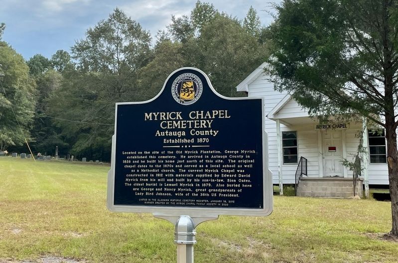
Myrick Chapel with cemetery on far left upper corner and marker.
| On County Road 99 north of County Road 68W, on the right when traveling north. |
| On County Road 21, 0.1 miles south of County Road 40, on the left when traveling south. |
| On Rocky Mount Road, 1.1 miles north of Cobbs Ford Road (U.S. 82), on the right when traveling north. |
| On County Road 21 south of County Road 20, on the right when traveling south. |
| On Daphne Road (County Road 64) near State Route 181, on the right when traveling west. |
| On Pine Grove Drive near Confederate Rest Road, on the right when traveling west. |
| On Canal Road (Alabama Route 180) at Pensacola Avenue, on the right when traveling east on Canal Road. |
| On Larry Dee Cawyer Drive at Old Spanish Trail (U.S. 98), on the left when traveling north on Larry Dee Cawyer Drive. |
| On Alabama Route 225, 4.7 miles north of Spanish Fort Blvd (U.S. 31), on the right when traveling north. |
| On U.S. 82 at County Route 79, on the right when traveling east on U.S. 82. |
| On John Scott Road near Bethel Road, on the left when traveling south. |
| Near Alabama Route 51 north of Clio Short Road, on the right when traveling north. |
| On Alabama 51 (Alabama Route 51) 0.1 miles north of Clio Short Road, on the right when traveling north. |
| On Danny Road, on the left when traveling west. |
| On North Randolph Avenue just south of East Browder Street, on the left when traveling south. |
| Near North Randolph Avenue at East Browder Street. |
| On Springhill Road (County Road 89), on the right when traveling west. |
| On County Road 89 west of County Road 49, on the left when traveling west. |
| Near Mill Street, 0.2 miles south of Walnut Street (State Route 25), on the right when traveling south. |
| On County Route 20, on the left when traveling north. |
| On U.S. 29 just north of Twin Trail, on the right when traveling south. |
| On County Route 19, on the right when traveling south. |
| On U.S. 82 west of Prairie Street, on the right when traveling east. |
| On State Highway 223 at County Road 22, on the left when traveling south on State Highway 223. |
| On Nickquenum Road, 2 miles south of Kirkville Road (County Road 75), on the left when traveling south. |
| On South Park Street at Deming Street, on the left when traveling south on South Park Street. |
| Near South Park Street north of Dunklin Street. |
| On McCullars Lane west of County Road 73, on the right when traveling east. |
| On McKibbon Street, 0.1 miles west of Ross Street, on the right when traveling west. |
| On U.S. 431, 0.1 miles south of County Route 222, on the right when traveling south. |
| On B Street, 0.4 miles south of 2nd Street SW, on the right when traveling south. |
| On Southeast Avenue A (County Route 50) 0.1 miles east of Southeast 3rd Street, on the right when traveling east. |
| On College Street (Route 20) 0.1 miles south of South River Road, on the right when traveling north. |
| Near County Route 587 at Troy Lane, on the right when traveling south. |
| On County Road 63, 0.6 miles north of State Route 143, on the right when traveling north. |
| Near County Road 45 north of County Road 315. |
| On Alabama Avenue, 0.1 miles north of County Road 74. |
| On County Road 752, 0.2 miles south of County Road 480, on the right when traveling north. |
| On Barrytown Road (County Road 14) east of Mosely Bridge Road, on the right when traveling east. |
| On Little Drive (Little Place Cemetery Drive), 0.2 miles east of Ararat Road (County Route 23), on the left when traveling east. |
| On Ararat Road (County Route 23) 7.2 miles north of Pleasant Hill Road, on the right when traveling east. |
| On Mt. Nebo Road, 0.4 miles north of Belqueen Road, on the right when traveling west. |
| On Rockville Road (County Road 15) at Suel Road, on the right when traveling south on Rockville Road. |
| On State Highway 5, 1 mile south of State Route 25, on the right when traveling south. |
| On Winn Road (County Road 3) 0.7 miles north of Zimco Road (Route 23), on the right when traveling north. |
| On Alabama Route 141, 0.4 miles south of County Route 404, on the left when traveling south. |
| Near County Road 484, 0.2 miles east of County Road 473, on the right when traveling east. |
| On Alabama Route 51, on the left when traveling south. |
| On Old Lee Highway (County Road 20) at Garner Lane, on the right when traveling west on Old Lee Highway. |
| On Mhoontown Road, 1.1 miles east of North Pike, on the right when traveling north. |
| On Mt. Pleasant Road (County Road 66) 0.3 miles east of County Line Road (County Road 48), on the right when traveling east. |
| On Old Hwy 20 east of Morgan Drive, on the right when traveling east. |
| On South Commons Street at South Hickory Street, on the right when traveling west on South Commons Street. |
| On SW 14th Avenue near SW 7th Street, on the right when traveling east. |
| Near County Road 15, 0.2 miles south of Doe Lane. |
| On Alabama Route 22 west of Alabama Route 9, on the right when traveling west. |
| On Lee Street (State Road 10) 1 mile west of Montgomery Highway (U.S. 331), on the right when traveling west. |
| Near 9th Street Southeast at Main Avenue Southwest. |
| On County Road 747, 0.1 miles south of County Road 1508, on the left when traveling south. |
| On Wesley Avenue (County Road 1669) 0.1 miles south of Cemetary Road, on the right when traveling north. |
| On County Road 846 north of County Road 844, on the right when traveling north. |
| On Kirby Richardson Road, on the right when traveling south. |
| On County Road 67 at County Road 16, on the left when traveling north on County Road 67. |
| On West Andrews Avenue (Route 249) east of Fairwood Circle, on the right when traveling west. |
| On Marley Mill Road (County Route 36) east of County Road 233, on the right when traveling east. |
| On West Andrews Avenue (Route 249) east of Fairwood Circle, on the right when traveling west. |
| On County Road 23, on the left when traveling south. |
| On Oak Street, 0.6 miles south of Capitol Avenue, on the right when traveling south. |
| On Oak Street, on the right when traveling south. |
| Near Cahaba Road, on the right when traveling north. |
| Near County Road 189, 0.4 miles west of County Road 45. Reported missing. |
| On County Road 9, 0.4 miles north of State Route 22, on the left when traveling north. |
| On County Road 12, 0.1 miles east of County Road 7, on the right when traveling east. |
| On Kings Street south of Dallas Avenue (State Highway 22), on the right when traveling south. |
| On State Highway 22 at County Road 65, on the right when traveling south on State Highway 22. |
| On Kings Street south of Dallas Avenue (State Highway 22), on the right when traveling south. |
| On County Road 37 north of County Road 65, on the right when traveling north. |
| On 38th Street Northeast south of Godfrey Avenue, on the right when traveling south. |
| Near Union Cemetery Road, 0.2 miles north of College Drive, on the left when traveling north. |
| On Alco Drive, 0.2 miles south of Blacksher Lane, on the right when traveling south. |
| Near Union Cemetery Road, 0.2 miles north of College Drive, on the left when traveling north. |
| Near South Sixth Street, 0.2 miles south of Oak Street. |
| On Rainbow Drive (U.S. 411) at Cemetery Road, on the right when traveling east on Rainbow Drive. |
| On Rainbow Drive (U.S. 411) east of Peteet Street, on the right when traveling east. |
| On Rainbow Drive (U.S. 411) east of Peteet Street, on the right when traveling east. |
| On County Road 78, on the right. |
| On North Shiloh Road, on the right when traveling south. |
| Near County Line Drive east of Kelly Street when traveling south. |
| On Stovall Drive, 0.5 miles south of Hayden Street, on the left when traveling south. |
| On Broad Street (Alabama Route 173) 0.8 miles south of County Road 17, on the right when traveling south. |
| On West Columbia Road, 0.2 miles east of County Road 7, on the right when traveling east. |
| On County Road 89 at County Road 109, on the right when traveling south on County Road 89. |
| On County Road 73, 0.3 miles north of County Road 138, on the left when traveling north. |
10932 entries matched your criteria. The first 100 are listed above.
Next 100 ⊳