After filtering for California, 566 entries match your criteria. The first 100 are listed. ⊳
Churches & Religion Topic
By Barry Swackhamer, November 24, 2014
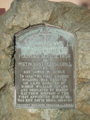
Alameda’s First Church Marker
| 1 ► California, Alameda County, Alameda — Alameda’s First Church — Founded Sept. 11, 1853 — |
| On Central Avenue at Oak Street, on the right when traveling west on Central Avenue. | |||
| 2 ► California, Alameda County, Alameda — First Presbyterian Church — |
| On Santa Clara Avenue at Chestnut Street on Santa Clara Avenue. | |||
| 3 ► California, Alameda County, Alameda — Tonarigumi — Alameda’s Historic Japantown — |
| On Pacific Avenue north of Park Street, on the right when traveling north. | |||
| 4 ► California, Alameda County, Alameda — Tonarigumi — Alameda’s Historic Japantown — |
| On Buena Vista Avenue south of Oak Street, on the right when traveling north. | |||
| 5 ► California, Alameda County, Berkeley, Central Berkeley — Site of Presentation High School and Convent — A City of Berkeley Landmark — |
| On California Street south of Addison Street, on the right when traveling north. | |||
| 6 ► California, Alameda County, Berkeley, Downtown Berkeley — Site of the Kellogg School — Berkeley History — |
| On Oxford Lane at Oxford Street on Oxford Lane. | |||
| 7 ► California, Alameda County, Berkeley, Elmwood — American Baptist Seminary of the West - Hobart Hall — City of Berkeley Landmark - designated in 1999 — Julia Morgan, Architect, 1919 — |
| Near Dwight Way at Hillegass Avenue. | |||
| 8 ► California, Alameda County, Berkeley, North Berkeley — North Berkeley Congregational (Grace North) Church — James W. Plachek, Architect, 1913 — |
| On Cedar Street near Walnut Street, on the right when traveling east. | |||
| 9 ► California, Alameda County, Berkeley, North Berkeley — Site of Napoleon Bonaparte Byrne House — 1868 — City of Berkeley Landmark — |
| On Oxford Street at Codornices Creek on Oxford Street. | |||
| 10 ► California, Alameda County, Berkeley, Northwest Berkeley — Bowen’s Inn/Higgins Grocery — Circa 1854 — City of Berkeley Landmark, designated in 1985 — |
| On Delaware Street east of 6th Street, on the right when traveling east. | |||
| 11 ► California, Alameda County, Berkeley, Northwest Berkeley — Church of the Good Shepherd — Charles L. Bugbee, Architect, 1878 — Listed on the National Register of Historic Places — |
| On Hearst Avenue at Ninth Street, on the right when traveling south on Hearst Avenue. | |||
| 12 ► California, Alameda County, Berkeley, South Berkeley — Lorin Theater — (Philips Temple C. M. E. Church) — City of Berkeley Landmark, designated in 1982 — |
| On Adeline Street south of Alcatraz Avenue, on the right when traveling south. | |||
| 13 ► California, Alameda County, Berkeley, Southside — First Church of Christ, Scientist — Bernard Maybeck, Architect, 1910 — |
| On Dwight Way at Bowditch Street, on the left when traveling east on Dwight Way. | |||
| 14 ► California, Alameda County, Berkeley, Southwest Berkeley — Workingman’s Hall — 1879 — Berkeley History — |
| On Seventh Street south of University Avenue, on the right when traveling south. | |||
| 15 ► California, Alameda County, Dublin — Heritage Park & Museums — |
| 16 ► California, Alameda County, Dublin — Kolb's "Sunday School" Barn — |
| Near Donlan Way. | |||
| 17 ► California, Alameda County, Dublin — Old St. Raymond’s Church — 1860 — |
| On Donlon Way, on the right when traveling south. | |||
| 18 ► California, Alameda County, Dublin — Tom Donlon — 1834 - 1859 — |
| Near Donlan Way. | |||
| 19 ► California, Alameda County, Fremont, Centerville — 246 — Pioneer Schoolhouse & Chapel — |
| On Temple Way near Utah Way, on the right when traveling north. | |||
| 20 ► California, Alameda County, Fremont, Centerville — The Beginnings of Centerville Presbyterian Church — By local historian Phil Homes — |
| On Bonde Way at Post Street, on the left when traveling east on Bonde Way. | |||
| 21 ► California, Alameda County, Fremont, Cherry - Guardino — 490 — Mormon Pioneers / Mormon Pioneer Adobes — |
| On Walnut Avenue at Gallaudet Drive, on the right when traveling east on Walnut Avenue. | |||
| 22 ► California, Alameda County, Fremont, Mission San Jose — Founding of Mission San Jose — |
| On Mission Boulevard at Washington Boulevard, on the right when traveling north on Mission Boulevard. | |||
| 23 ► California, Alameda County, Fremont, Mission San Jose — 334 — Mission San José — |
| On Mission Boulevard at Washington Boulevard, on the right when traveling north on Mission Boulevard. | |||
| 24 ► California, Alameda County, Fremont, Vineyards - Avalon — The Ohlones and the Mission San Jose — Rancho Higuera Historical Park — |
| On Rancho Higuera Road south of Curtner Road, on the left when traveling south. | |||
| 25 ► California, Alameda County, Hayward — 1025 — Honcharenko’s Sanctuary — |
| Near Garin Avenue. | |||
| 26 ► California, Alameda County, Hayward — I.D.E.S. Council Hayward #14 — Irmandade do Divino Espirito Santo — Brotherhood of the Divine Holy Spirit — |
| On C Street at 1st Street, on the right when traveling east on C Street. | |||
| 27 ► California, Alameda County, Hayward — Ukrania — "Revenge on the Wolves that Devour the Lambs" — |
| 28 ► California, Alameda County, Hayward — 1025 — Ukrania — |
| 29 ► California, Alameda County, Livermore — Brushy Peak Regional Preserve — |
| On West Side Loop Trail west of Laughlin Road, on the right when traveling west. | |||
| 30 ► California, Alameda County, Livermore — 391 — First Presbyterian Church Memorial Chapel — Built 1874 — American Presbyterian and Reformed Historical Site — |
| On Fourth Street at S K Street on Fourth Street. | |||
| 31 ► California, Alameda County, Livermore, Brushy Peak Regional Preserve — Brushy Peak Regional Preserve — |
| Near Laughlin Road north of Lake Drive, on the right when traveling north. | |||
| 32 ► California, Alameda County, Oakland, Downtown Oakland — 896 — First Unitarian Church of Oakland — |
| On Fourteenth Street at Castro Street, on the left on Fourteenth Street. | |||
| 33 ► California, Alameda County, Oakland, East Lake — 694 — Church of St. James the Apostle |
| On 12th Avenue at Foothill Boulevard, on the left when traveling south on 12th Avenue. Reported missing. | |||
| 34 ► California, Alameda County, Oakland, Joaquin Miller Park — Pyramid to Moses — 1892 — |
| Near Sanborn Drive east of Lookout Point, on the right when traveling east. | |||
| 35 ► California, Alameda County, Oakland, Mountain View Cemetery — Rev. Laurentine Hamilton — 1826 – 1882 — |
| Near Main Avenue near Piedmont Avenue, on the right when traveling east. | |||
| 36 ► California, Alameda County, Oakland, Mountain View Cemetery — William Taylor — United Methodist Historic Site — |
| Near Piedmont Avenue north of Ramona Avenue when traveling north. | |||
| 37 ► California, Alameda County, Oakland, Pill Hill — St. Augustine's Episcopal Church — Oakland Landmark Number 29 — |
| On 29th Street at Telegraph Avenue, on the right when traveling south on 29th Street. | |||
| 38 ► California, Alameda County, Oakland, Woodminster — Commemoration of Old Redwood Road from Redwood Canyon — |
| Near Mountain Boulevard. | |||
| 39 ► California, Alameda County, Piedmont, Oakmore — Corpus Christi Church — All Are Welcome — |
| On St. James Drive, on the right when traveling north. | |||
| 40 ► California, Alameda County, San Leandro, Old San Leandro — The Little Brown Church — |
| On Clarke Street near West Estudillo Avenue. | |||
| 41 ► California, Amador County, Ione — 506 — Methodist Episcopal Church — |
| On West Marlette Street at South Sacramento St, on the left when traveling south on West Marlette Street. | |||
| 42 ► California, Amador County, Jackson — Archimandrite Sebastian Dabovich — |
| On North Main Street, on the right when traveling north. | |||
| 43 ► California, Amador County, Jackson — 865 — Site of Pioneer Jewish Synagogue — |
| On Church Street at North Street, on the right when traveling north on Church Street. | |||
| 44 ► California, Amador County, Jackson — St. Sava Serbian Orthodox Church — |
| 45 ► California, Amador County, Sutter Creek — 135 Amelia Street — Sutter Creek — |
| On Amelia Street south of Old California 49, on the right when traveling south. | |||
| 46 ► California, Amador County, Sutter Creek — Sutter Creek United Methodist Church — |
| On Main Street (Old Highway 49) near Church Street, on the right when traveling north. | |||
| 47 ► California, Butte County, Chico — The Historic Home of Annie and John Bidwell — A House With a Style — |
| Near Esplanade near Memorial Way. | |||
| 48 ► California, Butte County, Magalia — Magalia Community Church / The Magalia Schoolhouse Bell — |
| On Skyway Road south of Magalia Cemetery Road. | |||
| 49 ► California, Butte County, Oroville — 770 — Chinese Temple — |
| On Broderick Street, on the right when traveling east. | |||
| 50 ► California, Butte County, Wyandotte — 141-04 — Dunstone Memorial Hall — |
| On Foothill Boulevard, 0.2 miles Dunstone Drive, on the right when traveling south. | |||
| 51 ► California, Calaveras County, Copperopolis — Congregational Church — |
| Near Main Street, 0.5 miles south of California Highway 4, on the left when traveling south. | |||
| 52 ► California, Calaveras County, Copperopolis — Copperopolis Armory — |
| On Main Street, on the left when traveling south. | |||
| 53 ► California, Calaveras County, Copperopolis — Copperopolis Historical Plaza — |
| On Main Street, on the right when traveling north. | |||
| 54 ► California, Calaveras County, Murphys — St. Patrick's Catholic Church — |
| Near Sheep Ranch Road, 0.1 miles east of Main Street. | |||
| 55 ► California, Colusa County, Colusa — 8 — Our Lady of Lourdes Church — |
| On Oak Street at 4th Street, on the left when traveling west on Oak Street. | |||
| 56 ► California, Colusa County, Grimes — COL-001 — Grand Island Shrine — |
| On California Route 45, 0.3 miles south of Buster Road, on the right when traveling south. | |||
| 57 ► California, Contra Costa County, Clayton — Endeavor Hall — |
| Near Center Street at Oak Street. | |||
| 58 ► California, Contra Costa County, Danville — First Presbyterian Church of Danville, 1875 — |
| On Front Street. | |||
| 59 ► California, Contra Costa County, Diablo — 905 — Mount Diablo — |
| On Summit Road, on the right when traveling north. | |||
| 60 ► California, Contra Costa County, El Cerrito — Holy Ghost Festa — |
| On San Pablo Avenue near Carlos Avenue, on the right when traveling north. | |||
| 61 ► California, Contra Costa County, Lafayette — Deodar Cedars — |
| On Moraga Road, on the right when traveling south. | |||
| 62 ► California, Contra Costa County, Lafayette — Lafayette Grammar School — |
| On Moraga Road, on the right when traveling south. | |||
| 63 ► California, Contra Costa County, Orinda — Santa Maria Church Bell — 1892 — |
| Near Santa Maria Way north of Altarinda Road when traveling north. | |||
| 64 ► California, Contra Costa County, Orinda — The Santa Maria Chapel, 1892 — |
| On Orinda Way at Santa Maria Way, on the right when traveling north on Orinda Way. | |||
| 65 ► California, Contra Costa County, Pittsburg — St. Peter Martyr of Verona Mission and Parish — 1884 – 1906 First Church — 1910 – 1931 Second Church — |
| On Marina Boulevard at Pelican Loop, on the right when traveling south on Marina Boulevard. | |||
| 66 ► California, Contra Costa County, Richmond, Point Richmond — Our Lady of Mercy Church — 301 West Richmond Avenue — 1902 — |
| On West Richmond Avenue north of Santa Fe Avenue, on the left when traveling north. | |||
| 67 ► California, Contra Costa County, Walnut Creek — 175 — First Church of Christ, Scientist — 1345 Locust St. — 1924 — |
| On Locust Street near Cypress Street. | |||
| 68 ► California, Contra Costa County, Walnut Creek — St. Mary's Catholic Church — |
| On South Main Street near Botelho Drive, on the right when traveling south. | |||
| 69 ► California, Contra Costa County, Walnut Creek — 114 — St. Mary's Catholic Church — 1245 S. Main St. — 1884 — |
| On South Main Street near Botelho Drive, on the right when traveling south. | |||
| 70 ► California, Contra Costa County, Walnut Creek — St. Paul's Episcopal Church (Walnut Creek, California) — |
| Near Trinity Avenue near Oakland Boulevard, on the right when traveling west. | |||
| 71 ► California, Contra Costa County, Walnut Creek — 181 — St. Paul's Mission Chapel — 1604 Locust St. — 1889 — |
| On Locust Street near Civic Drive. | |||
| 72 ► California, Contra Costa County, Walnut Creek — 176 — Walnut Creek Methodist Church — 1370 Locust St. — 1872 — |
| On Locust Street near Cypress Street, on the right when traveling north. | |||
| 73 ► California, Contra Costa County, Walnut Creek — 174 — Walnut Creek Presbyterian Church — 1321 Locust St. — |
| On Locust Street near Mt. Diablo Boulevard. | |||
| 74 ► California, El Dorado County, Coloma — Changing California — |
| Near Coloma Road (California Route 49) north of Mt Murphy Road. | |||
| 75 ► California, El Dorado County, Coloma — Emmanuel Church — |
| On Church Street east of High Street, on the left when traveling west. | |||
| 76 ► California, El Dorado County, Coloma — Saint John's Church — |
| On Church Street at Marshall Park Way, on the right when traveling south on Church Street. | |||
| 77 ► California, El Dorado County, Georgetown — Georgetown Community United Methodist Church — |
| Near Church Street north of School Street, on the right when traveling north. | |||
| 78 ► California, El Dorado County, Georgetown — St. James Catholic Church — Built 1923 — |
| Near Front Street just north of Georgetown Road (California Highway 193). | |||
| 79 ► California, El Dorado County, Placerville — 767 — Methodist Episcopal Church — |
| Near Thompson Way. | |||
| 80 ► California, Fresno County, Clovis — Academy Methodist Church — |
| On Madsen Avenue, 0.2 miles north of State Route 168, on the left when traveling north. | |||
| 81 ► California, Fresno County, Coalinga — “Dr. Bill” — Born August 4, 1904 – Passed September 27, 1963 — |
| On Coalinga Plaza (North 5th Street) north of East Cedar Avenue, on the right when traveling north. | |||
| 82 ► California, Fresno County, Coalinga — First Presbyterian Church of Coalinga — Built 1908 – Dismantled 1981 — |
| On Sunset Avenue just south of West Madison Street, on the right when traveling south. | |||
| 83 ► California, Fresno County, Coalinga — St. Paul’s Catholic Church — Original Church built 1907 – Moved to Huron 1949 — |
| On Sunset Avenue at West Jefferson Street, on the left when traveling north on Sunset Avenue. | |||
| 84 ► California, Humboldt County, Arcata — First Methodist Society on Humboldt Bay — |
| On 8th Street at G Street on 8th Street. | |||
| 85 ► California, Humboldt County, Eureka — Harold G Larsen — 1925 - 1972 — Vista Point — |
| Near Highway 101 at S Broadway Street, on the right when traveling north. | |||
| 86 ► California, Humboldt County, Eureka — Saint Innocent of Alaska — |
| On F Street south of 9th Street, on the right when traveling north. | |||
| 87 ► California, Humboldt County, Eureka — St. Bernard Catholic Church — |
| On H Street at 6th Street, on the left when traveling south on H Street. | |||
| 88 ► California, Humboldt County, Trinidad — Holy Trinity Church — |
| On Hector Street at East Street, on the right when traveling north on Hector Street. | |||
| 89 ► California, Imperial County, El Centro — 1 — Mormon Battalion — |
| On Kumeyaay Highway (Interstate 8) west of Silsbee Road, on the right when traveling west. | |||
| 90 ► California, Imperial County, Holtville — Imperial Valley Church of the Brethren Site - Dunkard Church — |
| On Vanderlinden Road at Interstate 8, on the right when traveling south on Vanderlinden Road. | |||
| 91 ► California, Imperial County, Niland — Leonard Knight's Salvation Mountain — |
| Near Beal Road near Telephone Road, on the right when traveling north. | |||
| 92 ► California, Imperial County, Niland — Salvation Mountain — |
| On Beal Road near Telephone Road, on the right when traveling north. | |||
| 93 ► California, Imperial County, Seeley — Rock Art — California and Baja California Rock Art — |
| Near Kumeyaay Highway (Interstate 8) 3 miles west of Forester Road (County Road S30), on the right when traveling east. | |||
| 94 ► California, Imperial County, Winterhaven — Fray Francisco Hermenegildo Garcés — Born April 12, 1738, Died July 19, 1781 — |
| On Quechan Drive, 0.1 miles north of Quechan Road, on the left when traveling north. | |||
| 95 ► California, Imperial County, Winterhaven — 350 — Site of Mission La Purisima Concepcion — 1780-1781 — |
| On Quechan Drive, 0.1 miles north of Quechan Road, on the left when traveling north. | |||
| 96 ► California, Imperial County, Winterhaven — 921 — Site of Mission San Pedro — Y San Pablo De Bicuner — |
| On West Mehring Road, 0.1 miles west of Imperial Road, on the right when traveling west. | |||
| 97 ► California, Inyo County, Death Valley National Park — Padre Crowley Point — In Memory of the Padre of the Desert — Father John J. Crowley 1891-1940 — |
| On California Route 190, 37 miles east of U.S. 395, on the left when traveling east. | |||
| 98 ► California, Kern County, Arvin — 371 — Francisco Garces O.F.M — |
| Near Bear Mountain Boulevard. | |||
| 99 ► California, Kern County, Bakersfield — First Baptist Church — |
| On Truxton Street near L Street, on the right when traveling west. | |||
| 100 ► California, Kern County, Bakersfield — First Presbyterian Church — |
| On 17th Street at H Street, on the left when traveling west on 17th Street. | |||
566 entries matched your criteria. The first 100 are listed above. Next 100 ⊳