By Forest McDermott, July 11, 2012
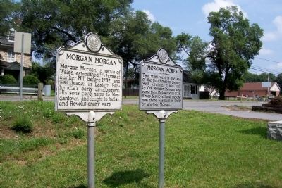
"Morgan Acres" Marker next to Morgan Morgan marker.
GEOGRAPHIC SORT Title Sort Marker Number Sort Marker Number Sort N Marker Number Sort T Publication Order Sort Publication Order Sort A Erected Year Sort Most Viewed Sort Most Recent-Interest Sort Most Recently Changed Sort SEE FAQ #33 FOR DESCRIPTIONS
On Winchester Pike (U.S. 11) north of Old Mill Road, on the right when traveling north. Reported missing.
On Runnymead Road, 0.4 miles west of U.S. 11, on the right when traveling west.
On Winchester Pike (U.S. 11) just north of Old Mill Road, on the right when traveling north.
On Runneymead Road, 0.5 miles west of Goldmiller Road, on the right when traveling east.
On Runnymeade Road (County Route 26) at Soldier Drive, on the right when traveling west on Runnymeade Road.
On Winchester Pike (U.S. 11) north of Old Mill Road, on the right when traveling north. Reported missing.
On Williamsport Pike (U.S. 11) east of Ripple Way, on the right when traveling west.
On Williamsport Pike (U.S. 11) east of Temple Drive, on the right when traveling west.
On Runnymeade Road (County Road 26) 0.4 miles west of Goldmiller Road (County Road 24), on the left when traveling west.
On Dominion Road, 0.1 miles south of Gerrardstown Road, on the left when traveling south.
On Gerrardstown Road (West Virginia Route 51) 0.1 miles east of Reunion Corner Road, on the left when traveling west.
On Runnymeade Road (County Road 26) 0.4 miles west of Goldmiller Road (County Road 24), on the right when traveling west.
On Hedgesville Road (West Virginia Route 9) near Mt. Zion Street, on the right.
On Route 9 Bike Path south of Short Road (County Route 9/19), on the right when traveling north.
On East John Street east of South Water Street, on the right when traveling west.
Paid Advertisement
On Williamsport Pike (U.S. 11) 0.4 miles north of Warm Springs Ave., on the right when traveling north.
On Winchester Avenue (U.S. 11) at Packhorse Ford Road, on the right when traveling south on Winchester Avenue.
On Winchester Avenue (U.S. 11) 0.2 miles south of Specks Run Road, on the right when traveling north.
On Shepherdstown Road (West Virginia Route 45) at Files Cross Road (Local Route 45/2), on the left when traveling east on Shepherdstown Road.
On Main Street (West Virginia Route 2), on the right when traveling north.
On West Virginia Route 2, 0.1 miles north of Cross Creek Road, on the right when traveling north.
On James River and Kanawha Turnpike East (County Route 60/33) at Tyree Street, on the right when traveling east on James River and Kanawha Turnpike East. Reported missing.
On U.S. 60 at West Virginia Route 41, on the right when traveling east on U.S. 60.
On George Washington Highway (U.S. 50) west of Cherry Ridge Road, on the left when traveling west.
On U.S. 220 just south of the city line, on the right when traveling south.
On U.S. 220, 0.2 miles west of Rig Road (County Road 10), on the left when traveling west.
On Virginia Avenue (West Virginia Route 55) east of Main Street (U.S. 220), on the right when traveling east. Reported missing.
On Alta Dr (West Virginia Route 12).
On Jefferson Street (U.S. 219) at Randolph Street, on the left when traveling north on Jefferson Street.
On Court Street north of Randolph Street, on the right when traveling north.
On Main Street West (U.S. 219) at Walnut Street (West Virginia Route 63), on the right when traveling west on Main Street West.
Paid Advertisement
Near Cold Stream Road (County Road 15) just north of Henderson Lane, on the right when traveling north.
On Cold Stream Road just south of Hillside Drive, on the right when traveling north.
Near Cold Stream Road (County Road 15) just south of Clark Hillside Drive, on the left when traveling south.
On Cold Stream Road (County Road 15) just south of Clark Hillside Drive, on the right when traveling north.
Near West Main Street (U.S. 50) at School Street, on the right when traveling west.
On West Gravel Lane just west of South High Street, on the right when traveling west.
On South High Street just north of East Gravel Lane, on the right when traveling south.
On East Main Street, 0.1 miles west of Campus Drive, on the left when traveling west.
On West Gravel Lane just west of South High Street, on the right when traveling west.
On West Virginia Route 2 north of Dry Run Road, on the right when traveling north.
On West Virginia Route 259, 0.6 miles south of Sawmill Lane, on the right when traveling north.
On West Virginia Route 259, 0.1 miles north of Howard's Lick River State Park Road (County Route 12), on the left when traveling south.
On West Virginia Route 220 at Old Fields Road (County Route 2), on the right when traveling north on State Route 220.
On Main Street (U.S. 48), on the right when traveling north.
Near Benedum Drive (West Virginia Route 131) 0.1 miles north of Northwestern Turnpike (U.S. 50), on the right when traveling north.
Near Benedum Drive (West Virginia Route 131) south of Park Avenue, on the right when traveling north.
Paid Advertisement
On Hood Avenue (U.S. 19) 0.2 miles south of Enterprise Road (County Road 19/2), on the right when traveling north.
On S. Pike Street (U.S. 19), on the right when traveling north.
On South Pike Street (U.S. 19) just north of Van Rufus Drive, on the right when traveling north.
On West Virginia Route 68, 0.2 miles east of U.S. 33, on the left when traveling north.
On George Street at Washington Street, on the right when traveling north on George Street.
On George Street at Washington Street on George Street.
On Route 9 Bike Path, 0.8 miles north of Currie Road, on the right when traveling north.
On Middleway Pike (West Virginia Route 51) east of Earle Road (West Virginia Route 51/1).
On Charles Town Rd (West Virginia Route 9) at John Ressler Road on Charles Town Rd.
On Middleway Pike (West Virginia Route 51) east of North Ridge Drive. Reported missing.
On South George Street (West Virginia Route 115) north of West Avis Street, on the right when traveling south.
On Summit Point Road (County Road 13) 0.2 miles west of McCormack Lane, on the right when traveling east.
Near South Potomac Street.
Near Potomac Street, on the right when traveling west.
On Fillmore Street, 0.2 miles east of Columbia Street, on the right when traveling east.
Paid Advertisement
On Public Way at Appalachian Trail, on the right when traveling north on Public Way.
On Charles Town Road (Route 9) 0.1 miles east of Charles Town Road (West Virginia Route 115), on the right when traveling east.
On Potomac Street, 0.1 miles north of Shenandoah Street, on the right when traveling north.
On Bakerton Road at Morning Calm Lane on Bakerton Road.
On Kearneysville-Virginia Line Road, 0.5 miles west of Leestown Pike, on the right when traveling west.
On Kearneysville Rd. at Charles Town Road, on the left when traveling west on Kearneysville Rd..
On Leetown Road at Paynes Ford Road, on the left when traveling north on Leetown Road.
On Route 9 Bike Path, 0.7 miles north of Leetown Road (County Road 1), on the right when traveling south.
On Route 9 Bike Path, 0.4 miles south of Luther Jones Road (County Road 16/4), on the right when traveling north.
On War Admiral Boulevard (West Virginia Route 9) at W. Burr Road, on the right when traveling south on War Admiral Boulevard.
On Ridge Road (County Road 16) 0.6 miles north of Luther Jones Road (County Road 16/4), on the left when traveling north.
Near Katie Lane, 0.1 miles east of Shepherd Grade Road.
On North King Street (West Virginia Route 480) 0.1 miles east of Shepherd Grade Road, on the right when traveling east.
On North Church Street (County Road 480/1) just north of Old Queen Alley, on the right when traveling north.
On German Street (West Virginia Route 230) at King Street, on the left when traveling west on German Street.
On South Duke Street (West Virginia Route 480) at Shepherd Grade Road, on the right when traveling west on South Duke Street.
Paid Advertisement
On North King Street (Route 480) 0.3 miles east of Shepherd Grade Road, on the right when traveling east.
On West German Street at South Church Street, on the right when traveling east on West German Street.
On Summit Point Road, on the right when traveling west.
On Summit Point Road (County Route 13) 0.2 miles east of McCormack Lane, on the right when traveling east.
On U.S. 60 near Kellys Creek Road (County Route 81), on the right when traveling east.
On U.S. 60, 0.3 miles east of Kellys Creek Road (County Route 81), on the right when traveling east.
Near Greenbrier Street (U.S. 60) at Quarrier Street, on the right when traveling north.
Near Greenbrier Street (U.S. 60) at Quarrier Street, on the right when traveling north.
Near Greenbrier Street (U.S. 60) at Quarrier Street, on the right when traveling north.
Near Greenbrier Street (U.S. 60) at Quarrier Street, on the right when traveling north.
On Kanawha Boulevard East (U.S. 60) at Veazey Street, on the right when traveling east on Kanawha Boulevard East.
On Fairlawn Avenue east of Lincoln Avenue, on the right when traveling east. Reported missing.
On Malden Drive (County Route 60/6) at Cypress Drive on Malden Drive. Reported permanently removed.
On MacCorkle Ave (U.S. 60) 0.4 miles east of Sattes Bridge.
On Paint Creek Road (Local Route 83) at Exit 74 (Interstate 77) on Paint Creek Road.
On Main Avenue at 1st Street, on the right when traveling north on Main Avenue.
Paid Advertisement
On 3rd Street (West Virginia Route 310) at Virginia Avenue, on the left when traveling south on 3rd Street.
On Meadowdale Road (County Route 73) at Pricketts Fort Road (County Route 72), on the left when traveling west on Meadowdale Road.
On Overfort Lane, 0.1 miles east of Wildwood Drive, on the right when traveling east.
On Main Street just north of 10th Street, on the left when traveling north.
On Krodel Park Road at West Virginia Route 62, on the left when traveling north on Krodel Park Road.
183 entries matched your criteria. The first 100 are listed above.
The final 83 ⊳