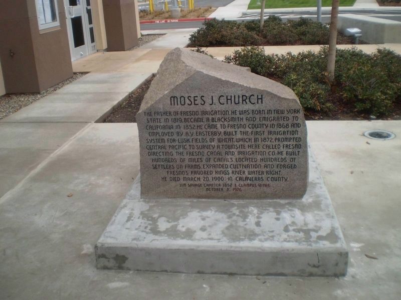
The Father of Fresno Irrigation. He was born in New York State in 1819, became a blacksmith and emigrated to California in 1852. He came to Fresno County in 1868 and employed by A. Y. Easterby, built the first irrigation system for lush fields of . . . — — Map (db m127909) HM
Built in 1883 by Moses J. Church, Fresno's first flour mill operated with Fancher Creek water run through Mill Ditch and down Fresno Street. The original wooden structure was replaced in 1892 by a brick building and was sold to the Sperry Flour . . . — — Map (db m69808) HM
Having water around a sawmill is a good thing. It’s easier to move logs and lumber, and put out fires. The Hume-Bennett Lumber Company found this site near good timber and decided a reservoir would make there operation more efficient. The problem . . . — — Map (db m44303) HM
Five miles southwesterly from this point, on both sides of Fresno
Slough, is the site of Fresno City. Fresno City gradually arose
at the head of navigation of Fresno Slough and existed from
approximately 1855 to 1875. The town served as a . . . — — Map (db m175903) HM
Steamboats carrying supplies for Millerton reached the head of navigation at Sycamore Point on the south bank of the San Joaquin River about one mile upstream from here. In the spring of 1852 and for many years thereafter paddle wheel steamers made . . . — — Map (db m229463) HM
Its waters made possible the irrigation of a million fertile acres, despite a 39 year battle over water rights. From 1882 forward, 150 lawsuits were filed and early irrigators often used armed force to open headgates to water their crops. L. A. . . . — — Map (db m27996) HM
Born in Canada in 1836, orphaned at age 8, he worked at numerous jobs before arriving in California in 1858. In his 40 years here he pioneered in photography, discovered Tehipite Valley and other prominent Sierra features. He led construction of the . . . — — Map (db m28156) HM
Arrived via Panama route, San Francisco Oct. 10, 1849
Arrived Colusi County, July 6, 1850
Ferry boat captain, mail carrier, surveyor, editor, writer, legislator, Surveyor General of the United States, California State Treasurer, irrigationist, . . . — — Map (db m143420) HM
Captain Jonathan Winship made the first recorded entry into Humboldt Bay by sea in June 1806. Encountered in 1849 by Josiah Gregg’s party. New word of its existence reached San Francisco. By 1850 the Laura Virginia Association had founded Humboldt . . . — — Map (db m1555) HM
Fishermen’s Terminal
Before the railroads reached Eureka in 1914, the ocean was the highway. The large green-roofed building to your right is the Fishermen’s Terminal built in the early 2000s. It sits upon the site of the Nelson Steamship Co. . . . — — Map (db m233409) HM
In 1876 John Gardner Kenyon surveyed and laid out this once flourishing southern Humboldt port. The original townsite encompassed 60 acres, subdivided by streets 60 to 80 feet wide. Shipping and other commercial ventures increased steadily from 1878 . . . — — Map (db m176156) HM
The 780 prisms and fresnel lenses in this replica of the original Cape Mendocino Light House were hand ground in France, shipped around Cape Horn and originally placed in operation at Cape Mendocino in 1868. The entire mechanical gear and prisms . . . — — Map (db m189002) HM
To the memory of the
38 pioneers who lost
their lives in the wreck
of the steamer "Northerner"
on January 6, 1860.
By Ferndale Parlor, NSGW, 1921.
Rebuilt because of
the earthquake of 1992.
Rededicated
February 11, 1995
by . . . — — Map (db m239831) HM
Lit Dec. 1, 1868 to Mar. 3, 1951.
Built at 422 ft. elevation, the light swept 30 mi. to sea. The perilous waters here claimed nine ships. Mules took supplies to the site, 15 mi. north, the westernmost in the U.S.
Dedicated to the Keepers of . . . — — Map (db m51954) HM
This propeller and tow bit was salvaged from the Eureka Slough by William Zerlang, where the Ranger had rested since 1926, when she was abandoned after serving on the bay since 1889. She was built up in North Bend, Oregon in 1887.
The propeller . . . — — Map (db m140014) HM
Inside you will interact with stories of the past, discover local culture, and view unique maritime artifacts
A group of local seafarers established the Humboldt Bay Maritime Museum in 1977 so residents and visitors could experience the . . . — — Map (db m81831) HM
The Mendocino presented a huge challenge to the designers of this lighthouse
The lighthouse’s assigned position was a storm-battered, 400-foot cliff prone to frequent earthquakes and landslides. The compact tower, with its lifesaving beacon, had to . . . — — Map (db m1108) HM
Lit Dec. 1, 1868, the light from its first order Fresnel lens swept 30 miles to sea. Decommissioned in 1951, the structure slowly began to inch toward the 422’ cliff. The light was dismantled in 1998 and moved to Point Delgada, Shelter Cove by . . . — — Map (db m1093) HM
1914–1998.
A founder of Shelter Cove with brothers Tony and Babe Machi. A ready smile, a friendly wave, a faraway look waiting for his fishermen to return—we’re thankful we’ve known this gentle man.
A hero in war. Survivor . . . — — Map (db m1057) HM
A new home in Shelter Cove. Shelter Cove is not the original home of the Cape Mendocino lighthouse. The lighthouse operated at Cape Mendocino, 35 miles north of here.
The compact metal tower was installed on a cliff at the cape in 1868 . . . — — Map (db m1107) HM
Founded April 8, 1850, Trinidad is the oldest town on the Northern California coast. During the 1850s, it served as a vital supply link between ships anchored at Trinidad Bay and miners in the Klamath, Trinity, Salmon River, and Gold Bluff mines. It . . . — — Map (db m1188) HM
The Trinidad Memorial Lighthouse is one of the most iconic landmarks on the North Coast and a beloved, historical symbol of the Trinidad community. The structure was built in 1949 as a replica of the original 1871 Trinidad Lighthouse, which . . . — — Map (db m139525) HM
Periodic winter flooding is not uncommon along California's Northcoast, and several floods have been catastrophic!
Try to imagine standing at this exact spot while 33 feet of river water rages overhead. Such was the scene in 1964, when a . . . — — Map (db m176729) HM
At this historic spot the first irrigation water from the Colorado River reached Imperial Valley in 1901, coming from Mexico. This waterway was replaced in 1942 by the All-American Canal. Water has made this once arid area into an agricultural . . . — — Map (db m176186) HM
The largest gravity fed irrigation district in the western hemisphere, established in 1911. They later assumed control of several water companies and were instrumental in getting the Hoover Dam and the All American Canal built.
They commenced . . . — — Map (db m62035) HM
The Alabama Gates and gate house were constructed in 1913 when the Los Angeles Aqueduct was built to dewater the aqueduct when maintenance is necessary. On November 16, 1924, seventy or more local citizens seized the aqueduct at the Alabama Gates . . . — — Map (db m93252) HM
People have long benefitted from the richness of the Owens
Lake area. For at least 10,000 years, American Indians have
lived here and harvested resources, including glass-sharp
obsidian for arrow points and spearheads.
In the . . . — — Map (db m221929) HM
Gordon’s Ferry was an overhead cable type of ferry operated during the 1850’s by Major Gordon. An adobe station house was located on the south bank of Kern River, just a few yards to the west of this marker. It was also a station on the Butterfield . . . — — Map (db m25149) HM
In 1947 the Tehachapi Soil Conservation District was organized to advise the farm industry. It was apparent by the early 1960s that if agriculture were to continue as economic force in the District, additional water had to be found. In the early . . . — — Map (db m135047) HM
1906-1914: City of Los Angeles builds and operates plant to make cement for Los Angeles Aqueduct and also constructs town named Aqueduct to house workers and families.
1910: Aqueduct train station and post office are renamed Monolith. . . . — — Map (db m52988) HM
Founded in 1856 by L.A. Whitmore who operated first Kings River ferry crossing. After 1858 town became stopping place for Butterfield stages. Toll bridge superseded ferry in 1873. On December 26, 1873, Tiburcio Vasquez and bandit gang made bold raid . . . — — Map (db m158224) HM
Baldwin Lake casts a long shadow of history at the core of the Arboretum, its four acres bearing witness to a who's who of settlers and owners of note over the years. Before recorded history, Gabrielino villagers called this home place . . . — — Map (db m177669) HM
The Catalina Island Yacht Club has been a welcoming landmark in Avalon Bay since the building was completed in 1924. One of the oldest and most unique yacht clubs in Southern California, it has a proud history rich in the lore and tradition of . . . — — Map (db m49679) HM
Known to the Mission Padres, Crystal Lake is the only natural lake in the San Gabriel Mountains. R.W. Dawson visited the lake in 1876, and later built a cabin nearby. Pasadena Judge Benjamin Eaton wrote in 1887 that "The water is clear as a crystal . . . — — Map (db m172024) HM
Los Angeles County
Flood Control District -
Cogswell Dam.
Purpose: Flood control and water conservation.
Type: Rockfill.
Drainage Area: 39.2 square miles.
Storage Capacity: 12,300 acre-feet.
Crest Height: 265 feet. . . . — — Map (db m212989) HM
Located about 10 miles south of here between Lake Pyramid and Castaic Lake lies the Castaic Powerplant. This facility, unlike others along the West Branch, is a pumping-generating plant owned and operated by Los Angeles Department of Water and . . . — — Map (db m196318) HM
Created in 1932 for the rowing events of the Xth Olympiad, the Stadium was the first manmade rowing course in the United States. Its width allowed four teams to race abreast, eliminating additional heats and allowing oarsmen to enter the finals at . . . — — Map (db m2614) HM
On the last day of October 1967, the RMS Queen Mary, the world's most famous ocean liner, would leave her native United Kingdom for the last time. Thirty-nine days and 14,500 nautical miles later she would arrive off the Southern California . . . — — Map (db m131292) HM
The Long Beach Navy Memorial pays tribute to the city’s naval heritage
Long Beach's naval history dates back to 1908 with the arrival of President Theodore Roosevelt's 16-ship Great White Fleet. By the 1920s Long Beach established itself . . . — — Map (db m157406) HM WM
The Transpacific Yacht Race, 2,225 nautical miles to Honolulu, is one of the great ocean races of the world. First launched in 1906, the race now features as many as 80 yachts, all completing for a place on the Transpac Walk of Fame. Past winners . . . — — Map (db m72450) HM
This iron cannon was installed on the USS Constitution “Old Ironsides”, which was launched October 21, 1797. First in action against French privateers in 1798, “Old Ironsides” rendered distinguished service against the British in 1812. — — Map (db m122534) HM WM
Water to nourish the City of Los Angeles now comes hundreds of miles via two great aqueducts — from the Owens River of the high sierra and the Colorado River — as well as locally from the Los Angeles River basin, original source of the . . . — — Map (db m163054) HM
Built by United States Work Projects Administration, 1940.
second marker:
Exact Center - City of Los Angeles
Point of balance of the plane of the City of Los Angeles, Lat. 34°07'31"N, Long. 118°23'57"W, Alt. 920 ft, . . . — — Map (db m199910) HM
Hollywood Reservoir
Capacity 2,500,000,000 gallons.
Maximum depth of water 183 feet.
Mulholland Dam
Work started August 1923.
Dam completed December 1924.
172,000 cubic yards of concrete.
Elevation of . . . — — Map (db m167864) HM
In Memoriam - U.S.S. Maine -
destroyed in Havana Harbor
February 15th 1898.
This tablet is cast from metal recovered from the U.S.S. Maine. — — Map (db m227337) HM WM
The Arroyo Seco flows down from the San Gabriel Mountains to join the Los Angeles River on its way to the ocean. This spot, where the two rivers flow together, the “confluence”, is near the birthplace of the city of Los Angeles.
The . . . — — Map (db m145223) HM
In 1893 the Southern Pacific Railroad Company completed its 4,720-foot wharf which served as a deep water port for the Los Angeles area. After San Pedro became Los Angeles' official harbor in 1897, shipping activity at Port Los Angeles declined. . . . — — Map (db m50984) HM
The varied habitats of Guashna, which includes the Ballona Wetlands, nurtures the Gabrielino-Tongva people
of the past, present, and future. Discover how this biodiversity contributes to their rich culture and survival.
Ti'at (Plank . . . — — Map (db m216623) HM
Panel 1: American Merchant Marine Veterans Memorial
The United States Merchant Marine has faithfully served our country in times of war and peace, hauling life and cargo to every corner of the world.
This memorial is dedicated . . . — — Map (db m67059) HM
Dedication: National Maritime Day, May 22, 2003.
[List of state and local government officials]
Gene Frank Construction, Builder. Randall B. Montgomery, Engraver. Jerry Sturm, JSA, Design Architect.
American Merchant Marine Veterans . . . — — Map (db m50928) HM
The Catalina Channel, about 25 miles wide and close to 500 fathoms deep (about 3,000 feet), separates Santa Catalina Island from the mainland. This part of the Pacific Ocean was first visited by Juan Rodriguez Cabrillo in 1542, sailing under the . . . — — Map (db m147299) HM
In 1892 Southern California Fish Corp. was the first cannery in Los Angeles Harbor. In 1903 a technique of preparing and canning was developed to can sardines, mackerel, bluefin tuna, yellowfin tuna and albacore. In 1912 the first fresh fish market . . . — — Map (db m85153) HM
Juan Rodriquez Cabrillo, exploring for Spain, discovered Alta California and named San Pedro Bay, “Bahia de los Fumos” (Bay of Smokes), October 1542. The smoke on the Bay shore came from the native Suang-Na Indian Fires. Sebastian . . . — — Map (db m127129) HM
Panel 1:
Harry Bridges
1901 – 1990
Founder of the ILWU
Panel 2:
Harry Bridges was an Australian seaman who came ashore and started longshoring in San Francisco in 1922. Unsafe working conditions, corrupt hiring . . . — — Map (db m72148) HM
San Pedro Plaza Park, originally known as
Plaza Park, was opened to the public on July
1, 1889, on 5 acres of land which was donated
to the community by Roman Sepulveda.
Though the park has no structures today, it
once contained a bandstand . . . — — Map (db m180628) HM
Panel 1:
1945:
March: Lane Victory is named for the former slave, Isaac Lane, founder of Lane College, in Jackson, Tennessee. The Victory Ship was one of a class of cargo ships designed and built during World War II by the . . . — — Map (db m131429) HM
Commonly referred to as the Great White Steamer, the ship was specially built by William Wrigley to serve his Catalina Island as a passenger ferry. She was christened on May 23, 1924. During World War II, she was requisitioned for use as a troop . . . — — Map (db m113426) HM
Vincent Thomas Bridge
The Vincent Thomas Bridge is considered the Port of Los Angeles' official welcoming monument. It was built in 1963 to connect Terminal Island to San Pedro, replacing municipal ferry service.
Initially . . . — — Map (db m224136) HM
Stephen M. White was elected Los Angeles County District Attorney in 1882, State Senator in 1886 and United States Senator in 1893. During his term in the United States Senate, Senator White’s most notable accomplishment was his successful . . . — — Map (db m52155) HM
Panel 1:
Terminal Island Memorial
From the early 1900s until World War II, the fishing village of "Fish Harbor" on Terminal Island was a thriving community of 3,000 people – primarily Japanese immigrants and their U.S.-born . . . — — Map (db m72145) HM
In 1852 German immigrant Augustus W. Timms obtained Sepulveda's Landing on the mudflats near here. He built a wharf, added a warehouse, corral and other facilities to service shipping and running of stages to Los Angeles. Timms was a pioneer in the . . . — — Map (db m50976) HM
Seal of the U.S.S. Los Angeles: 1945 - 1977 U.S.S. Los Angeles
Naval Monument
Heavy Cruiser CA-135
To the personnel and ships
of the United States Navy
Anchors - loan United States Navy
Mainmast & mooring bitts - donated . . . — — Map (db m71839) HM WM
Panel 1:
On April 19, 1989, a powder explosion occurred in Turret 2 while IOWA was conducting peace-time gunnery drills off the island of Viesques, Puerto Rico. Preparing to fire, the center gun's powder bags exploded before the breech . . . — — Map (db m70263) HM
Where Does Your Water Come From?
Discover the history of water in Los Angeles and learn how the future of water is our future.
The Los Angeles River
About 15,000 years ago, people began moving into the Los Angeles Basin . . . — — Map (db m188162) HM
This is the terminus of the Los Angeles-Owens River Aqueduct, which brings water 338 miles from the eastern slopes of the Sierra Nevada to the City of Los Angeles. Begun in 1905, the great aqueduct was completed November 5, 1913. The Mono Craters . . . — — Map (db m164815) HM
On November 5, 1913, 40,000 people gathered here to witness the dedication of the Los Angeles - Owens River Aqueduct. The terminus of a 233-mile long engineering marvel, the Cascades were the site of William Mulholland‘s famous speech: “There it is, . . . — — Map (db m165409) HM
Today, Ballona Lagoon is a 16-acre remnant of a formerly extensive coastal wetland. Like other southern California wetlands, urbanization has reduced its size and degraded its habitat over the last century. Historically, Ballona was much larger . . . — — Map (db m128456) HM
Inspired by the canals of Venice, Italy. Built 1906. Declared 1983, Historic Cultural Monument No. 270, Cultural Heritage Commission, City of Los Angeles, Cultural Affairs Department. — — Map (db m178246) HM
The historic Gondolas of the Venice Canals were designed by Arthur L. Reese,
who was nicknamed 'The Wizard of Venice' for his many innovative creations and
extraordinary business successes in Venice, Ocean Park, and Santa Monica. Abbot
Kinney . . . — — Map (db m224675) HM
This memorial plaque commemorates the
early struggle of West Coast Longshoremen to establish hours, wages, and
working conditions. It specifically recalls
the day, May 15, 1934, when fighting broke
out on the waterfront near this . . . — — Map (db m180230) HM
On October 10, 1542 famed Spanish explorer Juan Rodriguez Cabrillo discovered a large Chumash Indian Village close to the sea at which he first claimed possession of Alta California lands for the King of Spain. He was greeted by the Indians who . . . — — Map (db m74707) HM
Malibu Lagoon is where Malibu Creek meets the Pacific Ocean. The result is a unique environment of plant and animal life adapted to fresh and salt water. Over two hundred species of birds can be seen here at various times of the year. Down these . . . — — Map (db m237677) HM
Designed by City Engineer A.L. Harris, this pier was constructed by the City of Manhattan beach during the years 1917-1920. The roundhouse building was added a year later. Harris' innovative design featured a rounded end to the pier, which helped it . . . — — Map (db m114457) HM
On December 12, 1957, near this site a groundbreaking ceremony took place to signal the start of construction of the Marina Del Rey small craft harbor, a revenue bond project of the County of Los Angeles.
Under the guidance of the Los . . . — — Map (db m128455) HM
Emerging from a Spanish land grant known as Rancho La Ballona, Marina Del Rey small craft harbor stands in testimony to the ingenuity of man in overcoming a myriad of obstacles posed by nature and artificial barriers raised by man himself. This . . . — — Map (db m138572) HM
The site was explored by Juan Rodriguez Cabrillo on Oct. 9, 1542, and named Pointe Vicente Bante Maria by Captain George Vancouver in 1793. Placed in service by the U.S. Lighthouse Service on May 1, 1926, it was renamed Point Vicente by the Pacific . . . — — Map (db m82001) HM
On the slopes below and west of this plaque stood the quarters of Portuguese whalemen who put out through the surf in boats under oars and sail to harpoon passing gray whales to be towed ashore where the blubber was stripped and "tried out" in large . . . — — Map (db m50975) HM
This is the location where the millrace turned due south, carrying water another 200 feet from this point into Chapman’s grist mill, built in 1822-25. The spring-fed water supply that flowed through the millrace came from two sources: Mission Lake . . . — — Map (db m79460) HM
After a breakwater was built in 1933 & 1934, Santa Monica Harbor became home to a proud collection of yachts, fleets of fishing boats, a cruise liner to Catalina and water taxis which served mobster Tony Cornero's infamous gambling ship, the "SS . . . — — Map (db m185313) HM
This elegant
Victorian social
hall from the
paddle steamer
China was salvaged
in 1886 when the
wood ship became
obsolete and was
burned for scrap
metal in Tiburon
Cove. To provide a
historic glimpse of
old-world . . . — — Map (db m154576) HM
These early photographs from the Belvedere-Tiburon Landmarks Society show Belvedere as a summer resort community. Historic panel provided by the Belvedere Community Foundation.
(Main photo:) Before the 1930s, land access to Tiburon was via . . . — — Map (db m154582) HM
PACIFIC MAIL STEAMSHIP CHINA
1866 - 1886
Length 360.0' Breadth 47.4' Depth 31.5'
William H. Webb designed and built the SS CHINA in New
York City for trans-Pacific passenger, cargo and mail service.
She came to her San . . . — — Map (db m154581) HM
William H. Webb has been called the greatest shipbuilder of the mid-
nineteenth century, an era that saw the development of the clipper ship, the
steam propelled vessel and the ironclad warship. His reputation was based
not only on the number, . . . — — Map (db m154577) HM
Since 1889, United States Life-Saving Service and Coast Guard crews have risked their lives to save shipwreck victims at Point Reyes. Brave crews of highly trained men struggled in some of the worst conditions in North America, sacrificing comfort, . . . — — Map (db m102689) HM
Point Reyes
Light Station
built 1870
has been placed on the
National Register
of Historic Places
by the United States
Department of the Interior — — Map (db m890) HM
No one knows how many cries for help went unanswered along this isolated coast. If shipwreck victims were not overcome by pounding surf, they would perish in a cold sea. But once the Life-Saving Station was established in 1889, victims of the coast . . . — — Map (db m102676) HM
FERRIES ON THE SAN FRANCISCO BAY
Dating back to the 1850s, ferry
service provided a vital link
between Marin County and
San Francisco. This changed
in 1937 when the Golden Gate
Bridge opened and ferry service
gradually declined. Between . . . — — Map (db m153337) HM
The Mighty Vessel
The terror of the Spaniards in the Pacific,
the Golden Hind was about 80 feet long in the
oak hull, 23 feet maximum breadth, and drew
13 feet of water. Her 18 cannons fired 6-pound
shot, outgunning every Spanish . . . — — Map (db m153381) HM
The bell from the James M. Donahue
ferry built in 1875 by Wm. E. Collyer
for the San Francisco & North Pacific
Railroad. Owned by Peter Donahue,
she provided service from Tiburon to
San Francisco until 1922.
Her remains lay under the San . . . — — Map (db m186786) HM
The Grace Quan is a reconstruction of a San Francisco Bay Shrimp junk. Between 1860 and 1910, these were the workhorse of the Bay Area's Chinese-owned dried shrimp industry. The Shrimp Junks closely resembled vessels from the fishermen's home . . . — — Map (db m102478) HM
At left, Angel Island on a clear winter day as the Eureka steams out of Sausalito. Originally named the Ukiah, she was built in 1923 and was once the largest ferryboat to operate on San Francisco Bay. With the capacity to hold 3,300 . . . — — Map (db m232290) HM
Sausalito, like other small coastal towns, had unpaved roads that led though town and up into the hills. The image on the left shows the condition of the streets circa 1890. This would soon change. As travel on the ferries and rails increased, so . . . — — Map (db m232209) HM
Marker One:
Before the Golden Gate Bridge opened in 1937, Sausalito was a transportation hub. In 1868 the Sausalito Land and Ferry Company established itself in a general office building and ferry dock in Sausalito at the foot of . . . — — Map (db m232201) HM
643 entries matched your criteria. Entries 101 through 200 are listed above. ⊲ Previous 100 — Next 100 ⊳