The Albemarle & Chesapeake Canal did not exist at the time of the Battle of Great Bridge…
...but plans for a canal at Great Bridge were in place more than three years before the battle. In 1772, the need for trade and commerce with North . . . — — Map (db m54955) HM
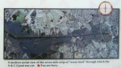
The Albemarle & Chesapeake Canal changed the landscape of this area.
Constructed between 1855 and 1859, the Albemarle & Chesapeake Canal cut through the causeway and marsh lying between the south island and the village of Great Bridge. The . . . — — Map (db m54949) HM
The Albemarle and Chesapeake Canal Gains Steam
By 1850, larger steam driven commercial carriers needed a faster, deeper and wider passage to market than the hand dug Dismal Swamp Canal, a few miles west of here. Digging the Dismal Swamp . . . — — Map (db m211245) HM
Both the Confederacy and the Union recognized the strategic importance of the Albemarle & Chesapeake Canal…and both sides fought for control.
The Albemarle & Chesapeake Canal (A&C) provided the Confederacy the means to avoid the coastal . . . — — Map (db m211943) HM
The village of Great Bridge was located at a strategic crossing of the Albemarle and Chesapeake Canal. This canal, along with the Dismal Swamp Canal, was recognized as being a strategically important corridor by both the Union and Confederate . . . — — Map (db m48919) HM
The Great Bridge village evolved to your left, where a bridge spanned the Elizabeth River. An early battle of the Revolution occurred around the bridge on December 9, 1775. The village grew with the completion of the Albemarle & Chesapeake Canal. . . . — — Map (db m211246) HM WM
The Battle of Great Bridge, in 1775, influenced everything you see today. Location, lives and legends are all here.
A. Great Bridge Lock Park
Enjoy a boat ramp, playground, picnic shelters and the many inviting vistas. Walk the . . . — — Map (db m48955) HM
Why doe the Canal Need a Lock?
The Great Bridge Lock is unique, because it is a guard lock—it guards water quality. Fresh water flows into the lock on your left from Currituck Sound in North Carolina. Salty water flows into the lock . . . — — Map (db m48960) HM
A Safer, Faster Route was Needed
Prior to the Revolutionary War, the most direct routes to transport goods to Norfolk and points north from North Carolina were, either the very slow overland route through the village of Great Bridge, or the . . . — — Map (db m48962) HM
Before you is the Dismal Swamp Canal, a much sought after prize of war during the Civil War. The Confederates made good use of the canal facilities during the initial stages of the conflict. A large volume of supplies passed through in both . . . — — Map (db m211247) HM
(main legend, lower right corner) The Dismal Swamp Canal Trail, a former section of Virginia State Route 17, is now a multi-purpose, linear, nature trail and park traversing some of the most uniquely historic and ecologically significant . . . — — Map (db m114520) HM
The walking path you are standing on right now has quite a history.
In 1804, it was a tow road on the eastern bank of the canal, where laborers, using long wooden poles, ropes or mules, pushed loaded barges full of shingles, lumber, corn . . . — — Map (db m114518) HM
Across the canal lies the US Fish & Wildlife Service's Great Dismal Swamp National Wildlife Refuge.
The Great Dismal Swamp was once a vast ecosystem that covered as much as one million acres of southeastern Virginia and northeastern . . . — — Map (db m114525) HM
Herring Ditch was one of many ditches that connected with the Dismal Swamp Canal. Ditches were used to transport goods to the canal, allow access to swamp timber, and provide drainage. Walter Herron, a Dismal Swamp Canal Company stockholder, began . . . — — Map (db m114521) HM
Approved by the Virginia General Assembly in 1818, the North West Canal was constructed by the Dismal Swamp Canal Company between 1828 and 1830. The canal was intended for carrying timber and farm products between the Dismal Swamp Canal and the . . . — — Map (db m114524) HM
Haphazardly scattered on the ground and under the water along the east bank of the canal, huge monoliths of chiseled stone may be waiting to be discovered. Each one found so far weighs more than 1,000 lbs. and averages 4-6 feet long. Made of . . . — — Map (db m224495) HM
"All persons sending or carrying Boats, Goods, etc. through the Canal must not forget taking money with them to pay the toll." Norfolk Herald, January 22, 1819 The Superintendent's House, is the last standing vestige of . . . — — Map (db m224496) HM
Just north is the birthplace of Commodore Richard Dale (6 Nov 1756 - 26 Feb 1826). He served on the United States brigantine Lexington. The British captured and wounded him several times during the Revolutionary War. Captain John Paul Jones . . . — — Map (db m40678) HM
The story of Dutch Gap demonstrates the importance of the river throughout history revealing a partnership of man’s use of land and water. Today, the river’s commercial and recreational activities continue, providing a backdrop to Dutch Gap’s . . . — — Map (db m16159) HM
Colonel Thomas Lygon, who came to the Virginia colony in the early 1640s from Worcestershire, England, patented several large parcels of land on the north bank of the Appomattox River in an area known as The Cowpens, near Mount My Lady, which was . . . — — Map (db m17131) HM
1611 Sir Thomas Dale and his men, using a tactic developed in the Dutch Low Country, dug a ditch and erected a fence across the neck of the peninsula for the defense of Henricus.
1864 Federal forces under General Benjamin Butler began . . . — — Map (db m87885) HM
With the opposing armies locked in a protracted struggle around Petersburg and Bermuda Hundred, the James and Appomattox Rivers assumed added importance. In August 1864, Union Gen. Benjamin Butler began excavations at Dutch Gap. When completed, . . . — — Map (db m16150) HM
(panel 1)
John Smith Explores the Chesapeake
Captain John Smith explored the Chesapeake Bay in the early 1600s seeking precious metals and a passage to Asia. He traveled the James, Chickahominy, and York rivers in 1607, and led . . . — — Map (db m128321) HM
Photograph of the ironclad ram Atlanta. The Atlanta was built by the Confederacy and was captured at Savannah Ga. by Federal forces in 1863. It saw service on the James River in the US Navy. The ship was decommissioned in 1865 and was . . . — — Map (db m87876) HM
This photograph of the Dutch Gap Canal was taken from near this location in 1865. It shows the canal with a dredge boat in the background. The canal was dug in an attempt to bypass Confederate gun positions at Battery Dantzler approximately one . . . — — Map (db m164325) HM
Photograph of the Union ironclad Saugus taken from near this location in March 1865. The log boom on the bow of the Saugus is a field adaptation to protect it from Confederate mines in the river.
This sign was sponsored by Edwin . . . — — Map (db m87877) HM
Native Americans 1500's
These boats were used by the Powhatan Indians to carry furs, food, and other trading items.
First Settlers 1600's
Shallops were wider and sometimes longer than canoes. They were propelled by oars or by . . . — — Map (db m87886) HM
The foundation is all that remains of the lightkeeper’s house. The lightkeeper had to live on site to maintain the gas-powered lights which were once located on the bluff. Lights were constructed after the first Dutch Gap channel was completed in . . . — — Map (db m16153) HM
The Battle of Trent's Reach
On the night of Jan. 23, 1865, the ironclads Virginia II, Richmond, and Fredericksburg, with five smaller vessels, descended the James River in an effort to attack the Union supply depot . . . — — Map (db m87879) HM
One of the most dramatic changes along the James River is the daily tide. The tides originating in the Atlantic Ocean influence the river all the way to the City of Richmond. Constant sources of freshwater from replenishing rainfalls and streams in . . . — — Map (db m87883) HM
While Union Maj. Gen. Benjamin F. Butler's Army of the James entrenched at Bermuda Hundred on 11 May 1864, Confederate Maj. Gen. Robert F. Hoke led parts of two divisions north from Petersburg to unite with Maj. Gen. Robert Ransom's division near . . . — — Map (db m17123) HM
You are now on Farrar's Island. Here in 1611, Sir Thomas Dale established the "Citie of Henryco", one of Virginia's first four primary settlement areas under the Virginia Company of London. Later, this land was part of a 2,000-acre patent issued . . . — — Map (db m149633) HM
Captain John Smith explored the Chesapeake Bay in the early 1600s seeking precious metals and a passage to the Pacific. He traveled the James, Chickahominy and York rivers in 1607, and led two major expeditions on the Chesapeake from Jamestown in . . . — — Map (db m149625) HM
Explore the places John Smith and the English colonists traveled in the early 1600s. Learn about the thriving American Indian communities and the bountiful richness that still exists in the region today.
For more than 3,000 miles, the . . . — — Map (db m149626) HM
This is a composite of two photographs taken of the Appomattox River from this location. The signal tower in the background was near present day R. Garland Dodd Park at Point of Rocks.
This sign was sponsored by Stewart O'Bannon III . . . — — Map (db m109396) HM
Broadway Landing was located three miles up the Appomattox River from City Point. It was the main supply depot for Federal artillery during the siege of Petersburg. Artillery pieces and ammunition were transported by ship or barge and offloaded . . . — — Map (db m109393) HM
Point of Rocks takes its name from a 60-foot high sandstone cliff located here along the Appomattox River. The site was used by Native Americans as a camp and observation point, and was mentioned by Captain John Smith in his notes on Virginia. A . . . — — Map (db m109399) HM
”On June 26,...just as we were having roll call and the men were about to retire for the night, the boom of a cannon a little way down the river, and the whizzing of a shell as it sped us by, aroused us to the fact that the enemy was . . . — — Map (db m109376) HM
The United States Submarine Propeller Alligator
The green, 47-foot-long Alligator was the U.S. Navy's first submarine—a technological wonder of the Civil War era.
French engineer Brutus de Villeroi designed the . . . — — Map (db m109375) HM
Gabriel Archer wrote about a high rock cliff that projected into the channel of the Appomattox River upstream of its confluence with the James. When exploring the river in 1608, Smith found verdant marshes the likes of which can still be seen here . . . — — Map (db m181457) HM
Directly across the river, Petersburg began to develop into a major industrial and commercial center. The town sprang up at the Appomattox River's fall line, where rocks and shallows prevented cargo boats from sailing upstream. Planters from the . . . — — Map (db m149613) HM
The Virginia State Normal School, now Virginia State University, purchased a two-acre tract with a mill building from John Stearns for the sum of $35,000 in 1922. The mill was used for silk dying and weaving and was one of many water powered mills . . . — — Map (db m149612) HM
Even though mills were thriving along the riverbank, it was not until the 1830s that the village of Ettrick took shape. In 1830, entrepreneur Jabez Smith and partner Edward Stokes purchased the old Campbell mills. By this time, the mill owners had . . . — — Map (db m149609) HM
A mile north, on the site of an important Appamatuck Indian village, Sir Thomas Dale established Bermuda Hundred in 1613. The hundred was a traditional English jurisdiction of one hundred families. Dale, the deputy governor and marshal of Virginia, . . . — — Map (db m11662) HM
Port Walthall, which stood on the banks of the Appomattox River several miles to the south, was a major shipping and passenger embarkation point prior to the Civil War. The railroad tracks leading to the port were melted down to manufacture . . . — — Map (db m11847) HM
(left panel)
Visiting Richmond National Battlefield Park
The concentration of Civil War resources found in the Richmond area is unparalleled. The National Park Service manages 13 sites, giving visitors an opportunity to examine the . . . — — Map (db m37022) HM
“Mr. President, these are the young heroes of Fort Darling…. The President took them all by the hand and personally thanked them for their magnificent conduct and example, ordered that each one should receive a Medal of honor and to be . . . — — Map (db m37027) HM
When Federal gunboats rounded the distant bend in the James, they entered a shooting gallery. Confederate soldiers and Marines along the riverbanks raked the decks with musket fire. Confederate guns here in the fort opened fire. The river . . . — — Map (db m37028) HM
During the Peninsula Campaign in the spring of 1862, a variety of innovative weapons saw action. But nothing captured the public’s attention more than ironclad warships, in particular the USS Monitor. After its epic duel with the CSS . . . — — Map (db m55346) HM
Wheat farming and flour milling were the backbone of the Clarke County economy for more than 150 years. Throughout those years, we were home to at least 60 mills and tiny Clarke County contributed mightily to the Shenandoah Valley's . . . — — Map (db m172247) HM
Ashby’s Gap was named in honor of John Ashby, a leader among local pioneers and reputedly the first person to haul a hogshead of tobacco through this gap. Part of the house standing just to the south may have been erected in the 1740s by Thomas . . . — — Map (db m1333) HM
A short distance east on the Appomattox River stands Confederate Fort Clifton, an important fortification that guarded Petersburg against Union naval attack during the Civil War. On 9 May 1864, Federal gunboats commanded by Maj. Gen. Charles K. . . . — — Map (db m173116) HM
In 1766 John Dix established his ferry approximately three miles south of here on the Dan River. During the American Revolution, in February 1781, the ferry was a strategic site in Gen. Nathanael Greene's “race to the Dan,” the pursuit . . . — — Map (db m108313) HM
[Unfortunately, the marker is heavily unreadable.]
These houses were rented to mill workers for nominal amounts. Records show that in 1933, 100 houses with a total of 588 rooms were rented to 330 workers. This rent comes to 56 cents per . . . — — Map (db m171805) HM
Hoping to cut Lee’s supply route into Petersburg, in February 1865 Grant ordered two army corps led by Major Generals Gouverneur K. Warren and Andrew A. Humphreys to seize the Boydton Plank Road. The Confederate corps commanded by Maj. Gen. John B. . . . — — Map (db m6486) HM
"The railroad bridge was a prime target during the Civil War. The Confederates built three forts on the south side of the bridge and rifle pits and obstructions on the north side. On December 7-12, 1864 the Yankees made their “Hicksford Raid”, . . . — — Map (db m226936) HM
Along the Rappahannock River near here lived the Portobacco Indians, who may have been part of the Portobaccos of Maryland. After moving to Virginia in the 1650's, they lived here in peace with their Indian neighbors, who spoke a similar dialect and . . . — — Map (db m7406) HM
Two miles northeast on the Rappahannock River, at
Coleman's Town, George Southern was operating a ferry by 1679. In the early 1700s, the Ley and Layton families ran the ferry, an ordinary, and a wharf. By midcentury, the community had become
a hub . . . — — Map (db m214590) HM
One mile north, on the Rappahannock River, is Saunders's Wharf, a center of transportation and commerce from the mid-1800s until 1937. Steamboats on the busy route that linked Fredericksburg and Baltimore picked up crops, livestock, raw . . . — — Map (db m214593) HM
At Piscataway, near here, the northern followers of Bacon the Rebel assembled in 1676. On July 10, 1676, an action was fought with Governor Berkeley's supporters, some of whom were killed and wounded. Several houses were burned. Passing here, the . . . — — Map (db m7489) HM
(panel 1)
Bountiful Marshes
Meandering stretches of area rivers, such as this section of the Rappahannock, produce large freshwater marshes. Virginia Indians valued them as rich sources of food, often locating settlements nearby. . . . — — Map (db m97182) HM
Tobacco was currency and the cash crop at the heart of the colonial Virginia economy when Captain Richard Hobbs of the ship Elizabeth and Mary anchored here in the 1660s and received a land patent for 800 acres. Colonel Benjamin Goodrich was . . . — — Map (db m235824) HM
In this region near the Rappahannock River once stood the Rappahannock Indian village of Toppahanock. When John Smith explored this region in 1607 and 1608, he found fourteen Rappahannock villages along both banks of the river. The river was the . . . — — Map (db m7410) HM
The Washington family land south of here, named Mount Vernon in the 1740s, was part of a grant made in 1677 by the Northern Neck proprietors to Col. Nicholas Spencer and Lt. Col. John Washington. George Washington’s great-grandfather. John . . . — — Map (db m794) HM
British warships took advantage of the width and depth of the Potomac River to sail up from the Chesapeake Bay during the War of 1812. Existing defenses were too weak to stop them from shelling Alexandria.
Aware that the nation’s Capitol was . . . — — Map (db m46129) HM
In the distance is Jones Point, designated as the southern corner of the District of Columbia by President George Washington. In 1790 Congress established the nation’s capital with a ten-mile square of land ceded by Virginia and Maryland. Alexandria . . . — — Map (db m154908) HM
"A batteau…is the most proper Vessel for water fencing by being flat bottom'd and will go in Shawl water.."
Anthony Whitting to George Washington, January 16, 1793
Although we do not have a . . . — — Map (db m182618) HM
1. Miller's Cottage, Kitchen, Garden and Orchard
Constructed 1770-1771. From 1770 to 1799, George Washington employed several millers who lived in this cottage.
2. Gristmill
Constructed 1770-1771. The mill had two sets of . . . — — Map (db m140954) HM
A punt is a flat-bottomed boat with a square-cut bow that was designed for use on small rivers or other shallow water. This type of vessel was very common in 18th-century America. George Washington's records show that punts were used by hired and . . . — — Map (db m182619) HM
On July 18, 1861, Gen. Irvin McDowell, the Union army commander, learned that the Confederate army had withdrawn from its Centreville earthworks to a strong defensive position behind Bull Run. McDowell ordered Gen. Daniel Tyler to reconnoiter the . . . — — Map (db m173364) HM
During the American Civil War (1861-1865), soldiers from both the Union North and the Confederate South built huts known as "winter quarters" to live in during the winter months when fighting and troop movements were usually minimal.
The Bull . . . — — Map (db m152386) HM
On the side of the trail, do you see the hill that curves around the path?
By connecting the man made walls on the right side of the trail to the natural hillside on your left, the Machens created an ice pond in the winter of 1853. The . . . — — Map (db m198309) HM
The dwelling house at Sully Plantation was built in 1794 by Richard Bland Lee on land that had been patented in 1725. Lee was the first congressman from Northern Virginia and an early member of Phi Beta Kappa. His vote brought the capital city to . . . — — Map (db m216) HM
These remnant pier stones provide a glimpse back to another century. The bridge across Cain's Branch provided important passage for people crossing during their journey to and from Sully on top of rural stone and mud roads.
This bridge was . . . — — Map (db m198298) HM
Built by Harrison G. Otis. A popular resort hotel during the last quarter of the 19th century, offering health of the 19th century mineral water from its Paradise Spring and the finest in southern cuisine. Presidents Arthur, Grant, Hayes, Roosevelt, . . . — — Map (db m112196) HM
Owned by just two families before its first restoration in 2002 this house was built by J .M. Fulmer just one year after finishing a larger home on Chapel Street next to the Clifton Baptist Church. The Spring House in the front yard once provided . . . — — Map (db m114528) HM
Built by H. Longley. Oscar Woody, who was a member of the railroad and sea postal services, bought the house in 1910. He was on duty on the Titanic when she went down on his 41st birthday. He was buried at sea on April 24, 1912. — — Map (db m112192) HM
Following a victory at the Second Battle of Manassas (Bull Run) and a stalemate at Ox Hill (Chantilly), Gen. Robert E. Lee and the Army of the Northern Virginia turned northward. Near here on 3 Sept. 1862, Gen. Thomas J. "Stonewall" Jackson's corps . . . — — Map (db m182178) HM
Hogsheads were used to transport tobacco to ports for overseas shipment. They were rolled by workers or drawn by ox over several miles to their destinations. A fully loaded hogshead could weigh hundreds of pounds.
Nearby Ox Road and Rolling . . . — — Map (db m194551) HM
Dedicated to Colonel Stephen H. Long (1784–1864), second and last Chief of the Corps of Topographical Engineers (1861–1863). A native of Hopkinton, N.H., Colonel Long spent the first eight years of his military career gathering scientific . . . — — Map (db m220907) HM
Confederate Maj. Gen. J.E.B. Stuart, operating well east of Gen. Robert E. Lee, consolidated three brigades of about 5,000 cavalry and horse artillery here on the evening of 27 June 1863. Separated from Lee by the vast Union army then crossing the . . . — — Map (db m198250) HM
George Washington walked, rode horseback, and boated through this region pursuing his dream of westward expansion—connecting the Atlantic seaboard to the frontier West. His efforts to reengineer, dam, channelize, and straighten the Potomac River . . . — — Map (db m182174) HM
George Washington walked, rode horseback, and boated through this region pursuing his dream of westward expansion—connecting the Atlantic Seaboard to the frontier West. His efforts to reengineer, dam, channelize, and straighten the Potomac River . . . — — Map (db m197946) HM
A mature deciduous forest, rich in American beech, oak, tulip poplar, and hickory trees, blankets and ancient headland of the Potomac River Gorge, white sycamore, silver maple, and boxelder trees dominate the flood-washed lowlands. A quiet . . . — — Map (db m197947) HM
This will become the great avenue into the Western Country. - George Washington
The stone wall you see nearby is not just any stone wall; it was built here in the late 1700s as part of George Washington's . . . — — Map (db m59681) HM
On the hill above stands Huntley, a Federal-style villa built about 1825 for Thomson F. Mason, a grandson of George Mason of Gunston Hall. Thomson Mason, a prominent Alexandria lawyer, served on the city council, as mayor, and also as president of . . . — — Map (db m7909) HM
This unique stone cabin was built c. 1909 by James A. Hawkins, a local banker and farmer. It originally served as the residence for a twenty acre farm that bordered Sugarland Run. The house was later occupied by the Martz and Carroll families up . . . — — Map (db m186876) HM
On St. Patrick's Day, March 17, 1863, Confederate Capt. John S. Mosby and 40 Partisan Rangers attacked the picket post of the 1st Vermont Cavalry guarding this station on the Alexandria, Loudoun and Hampshire Railroad. The detachment commander Lt. . . . — — Map (db m151048) HM
The troop transport Dorchester was crossing the North Atlantic. On February 3, 1943, the deadly enemy submarines struck the Dorchester. The tragedy brought shouts of anger cries of fear, and wails of pain. The Four Chaplains gave their life . . . — — Map (db m145014) HM WM
Rivers have long served as transportation routes for all manner of boats and vessels, for Native Americans and European settlers, to recreational and commercial traffic today. The Occoquan and other rivers flowing eastward from the Virginia piedmont . . . — — Map (db m145082) HM
Colchester, founded in 1753 at the location of a ferry crossing, was the second town established in Fairfax County. Located on the main post road from Boston to Charleston, and at the end of the Ox Road leading west to the Blue Ridge, the town . . . — — Map (db m206) HM
(Panel 1)
The Battle of the White House Gun Battery, September 1-5, 1814, was the first military action in the region after the British attack on Washington. Named for a nearby white house, the battery was located at today’s Fort Belvoir. . . . — — Map (db m98160) HM
Some of the features shown here that were prominent on Mason Neck in Fairfax County during the marches of the Armies of the American War of Independence, exist today through generations of historic preservation efforts. The rich natural . . . — — Map (db m198378) HM
An engineer who believed science must serve people; a citizen who believed one person could make a difference, and did.
The Potomac River in the 1960's was one of the most polluted waterways in the country. The major source of Potomac . . . — — Map (db m8908) HM
Late in the American War for Independence, allied generals George Washington and the Comte de Rochambeau received good news. A French fleet under Admiral de Grasse carrying 3,000 French soldiers was headed for the Chesapeake Bay. Following the . . . — — Map (db m243223) HM
991 entries matched your criteria. Entries 201 through 300 are listed above. ⊲ Previous 100 — Next 100 ⊳