Near Carquinez Scenic Drive near Talbart Street, on the right when traveling west.
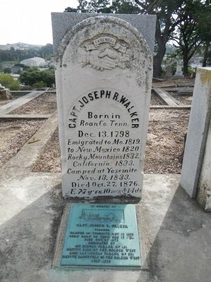
This monument erected in honor of his contributions as a soldier, mountain man, and explorer who through his efforts and those of his breed such as Jim Bridger, Thomas Fitzpatrick, Jedediah Smith, helped explore and open the way to the West. There . . . — — Map (db m93508) HM
Near Alhambra Avenue, on the right when traveling south.
Ranch home of John Muir 1838- 1914, explorer, naturalist, author and foremost advocate of forest protection and of national parks. The John Muir Trail through the High Sierra, Muir Woods National Monument and Muir Glacier in Alaska are named for . . . — — Map (db m51132) HM
Near St. Marys Road, 0.1 miles east of Moraga Road.
Grandfather of the co-grantee of Rancho Laguna de los Palos Colorados, he founded San Francisco by establishing there the Mission and Royal Presidio of St. Francis in 1776. In 1777 he founded the Mission Santa Clara and the Pueblo of San Jose. . . . — — Map (db m91803) HM
"...what we see and have before us is
not a river, but much water in a pond."
In the spring of 1776, Lt. Colonel Jaan Bautista de Anza,
Father Pedro Font, and a small group spent four days
exploring the East Bay. They wished to . . . — — Map (db m190712) HM
The 1775-76 expedition of Juan Bautista de Anza
made this site their one hundred first camp from
Horcasitas, Sonora, Mexico. Anza brought 198
colonists, located for Spain the Presidio of San
Francisco and Mission Dolores, and explored . . . — — Map (db m190721) HM
The Juan Bautista de Anza Expedition of 1775-1776 traveled with
240 settlers, soldiers, and others 1,800 miles from Sonora, Mexico
to Monterey, California. Anza then traveled with a much smaller
group to San Francisco and the East Bay to discover . . . — — Map (db m190230) HM
In 1775 and 1776, Lt. Colonel Juan Bautista de Anza, Father
Pedro Font, along with 240 settlers, soldiers, and others traveled
1,800 miles from Sonora, Mexico to Monterey, California. Anza
and Font, with a small group passed through by horseback . . . — — Map (db m145988) HM
On Parker Avenue south of 4th Street, on the right when traveling north.
Lt. Colonel Juan Bautista de Anza by Decree of Carlo III of Spain led an expedition near this site — the mission being to colonize the San Francisco Bay Area
In the center of the marker is a circular motif, designed by Doris Birkland . . . — — Map (db m24728) HM
Near San Ramon Valley Boulevard south of Pine Valley Road, on the right when traveling south.
Take a walk down the path and imagine what life might have been like here 200 years ago. Oak Creek would have provided fresh water and an abundance of plant material and wildlife for food and shelter. Houses would have been built with willow . . . — — Map (db m202104) HM
Near Coloma Road (California Route 49) north of Mt Murphy Road.
If you had stood on this spot in 1769, 1823, and 1848, you would have been in three different countries! Each time California switched hands, life changed for its people.
Spanish Province
“California” was a Spanish province in 1769. For the . . . — — Map (db m214606) HM
Near Coloma Road (California Route 49) north of Mt Murphy Road.
In the years leading up to the Gold Rush, life changed dramatically for the Nisenan who called this valley home.
Cullumah
To the Nisenan, “Cullumah” was home. For generations, they thrived in the valley and mountains, building large . . . — — Map (db m214607) HM
Near Coloma Road (California Route 49) north of Mt Murphy Road.
John Sutter and James Marshall came to California with dreams of a brighter future, but they never imagined their future would hold gold!
New Beginning
For both Sutter and Marshall, California was a land of opportunity. A persuasive . . . — — Map (db m214608) HM
On Monument Road (California Route 153) at Marshall Park Way on Monument Road.
Panel One:
New Jersey-born James Wilson Marshall came to John Sutter’s fort at Sacramento in July 1845, just a year before the American conquest of California. Trained as a carpenter and wheelwright by his father, Marshall quickly found . . . — — Map (db m215533) HM
Near Coloma Road (California Route 49) north of Mt Murphy Road.
For a brief moment, Coloma was the destination for anyone seeking their fortune in California’s gold fields.
Gold Rush Town
Almost overnight, migrants from around the world turned Coloma into a town of tent dwellings, hotels, and stores. . . . — — Map (db m214630) HM
Near Coloma Road (California Route 49) north of Mt Murphy Road.
In 1946, President James K. Polk authorized the Army to enlist Mormons to fight in the Mexican War. 496 men joined the Mormon Battalion in Council Bluffs, Iowa on July 16, 1846. They marched over 2,000 miles, building a wagon road from Santa Fe to . . . — — Map (db m215525) HM
Near Coloma Road (California Route 49) north of Mt Murphy Road.
Caught up in the frenzied news about the gold discovery, thousand of gold seekers from all corners of the world flooded into Coloma.
Fortune Seekers
California’s gold fields offered boundless opportunity and the hop of a brighter future. . . . — — Map (db m214879) HM
On Pony Express Trail (Lincoln Highway) at Forebay Road, on the right when traveling east on Pony Express Trail (Lincoln Highway).
Shortly after James W Marshall discovered gold at Sutter's Mill, his Mormon laborers were re-called to the Great Salt Lake Valley, Utah. On April, 9, 1848, a plan was devised to cut a wagon trail through the uncharted Sierra Nevada frontier. The . . . — — Map (db m94636) HM
Near West Kearney Boulevard, 0.3 miles west of South Bryan Avenue.
Fremont passed within sight of this spot on April 7, 1844. He was crossing from the San Joaquin River to the Kings River with his mountain men guides, Thomas "Broken Hand" Fitzpatrick, Kit Carson and Alex Godey. Fremont described a vast prairie with . . . — — Map (db m229460) HM
On 6th Street at K Street, on the right when traveling west on 6th Street.
After finding Humboldt Bay from the sand dunes near Fairhaven on December 20, 1849, the Dr. Josiah Gregg exploring party reached the present site of Eureka. December 26, passing an open area near this point, to camp by an Indian village close to . . . — — Map (db m91923) HM
On East 5th Street at Heber Avenue, on the right when traveling west on East 5th Street.
Here on September 23, 1849, Lieut. Cave J. Couts, Escort Commander, International Boundary Commission, established Camp Salvation. From September till the first of December 1849, it served as a refugee center for distressed emigrants attempting to . . . — — Map (db m50586) HM
On Kumeyaay Highway (Interstate 8) west of Silsbee Road, on the right when traveling west.
On Friday January 15, 1847 the Mormon Battalion, a volunteer unit of the Army of the West, crossed Interstate Highway 8 approximately seven miles west of this point. Lieutenant Colonel Philip St. George Cooke commanded this battalion when the . . . — — Map (db m191654) HM WM
On Interstate 8 at milepost 108, on the right when traveling east.
Known as Santa Rosa De Las Lajas (Flat Rocks), this site was used on March 8, 1774 by the Anza exploring expedition, opening the land route from Sonora, Mexico, to Alta California. On December 11 to 15, 1775 the three divisions of Anza's colonizing . . . — — Map (db m62074) HM
Near Center of The World Plaza, 0.1 miles north of Frontage Road, on the left when traveling north.
A 1533 expedition sent by Hernan Cortes discovered Baja California,
leading to the name "California" and the belief that it was the famed
Island of California which then appeared on maps of the era.
Exploration and Cartography
. . . — — Map (db m165827) HM
Juan Bautista De Anza led two groups of Spanish explorers and settlers across this portion of the Colorado Desert from Northern Mexico to San Francisco Bay. During each tortuous passage, the Spanish camped below here in Yuha Wash. The passage in . . . — — Map (db m50683) HM
Used by the Kamias Indians who showed it to Anza's scouts on March 8, 1774. The second Anza Expedition passed here on December 11, 1775. Later an important water source on the trail from Yuma to San Diego. — — Map (db m50363) HM
On Interstate 186, 0.2 miles south of Interstate 8, on the left when traveling south.
Alarcon's mission was to provide supplies for Francisco Coronado's expedition in search of the fabled Seven Cities of Cibola. The Spaniards led by Hernando De Alarcon ascended the Colorado River by boat from the Gulf of California past this point, . . . — — Map (db m88572) HM
As Avi-Milikit of Quechen legends; Picacho noted Spanish arrival in 1640, lured Sonora miners after 1852, brought steamboats to its mining and milling port until 1910. Her mines were never worked to extinction, but Picacho became a squatter haven. . . . — — Map (db m51576) HM
On West Mehring Road, 0.1 miles west of Imperial Road, on the right when traveling west.
To protect the Anza Trail where it forded the Colorado River, the Spanish founded a pueblo and mission nearby on January 7, 1781. Threatened with the loss of their land, the Quechans (Yumas) attacked this strategic settlement on July 17, 1781. The . . . — — Map (db m29057) HM
On Badwater Road, 17 miles south of California Route 190, on the right when traveling south.
Good Life in Badwater
Water is rare and precious in Death Valley. Imagine the disappointment when a surveyor mapping this area could not get his
mule to drink from this pool. He wrote on his map that the
spring had "bad water," and . . . — — Map (db m159465) HM
On California Route 190 at Badwater Road, on the right when traveling west on State Route 190.
Through this natural gateway the Death Valley Forty-Niners, more than one hundred emigrants from the middle west, seeking a shortcut to gold fields of central California, entered Death Valley in
December, 1849. All suffered from thirst and . . . — — Map (db m167508) HM
On Stovepipe Wells Road, 0.8 miles west of Scotty's Castle Road, on the right when traveling west.
This waterhole, only one in the sand dune area of Death Valley, was at the junction of two Indian trails. During the bonanza days of Rhyolite and Skidoo it was the only known water source on the cross-valley road. When sand obscured the spot, a . . . — — Map (db m94591) HM
On Trona Wildrose Road at Ballarat Road, on the right when traveling north on Trona Wildrose Road.
Now a ghost town, Ballarat served nearby mining camps from 1897 to 1917. They produced nearly a million in gold. The jail & a few adobe ruins remain. Seldom Seen Slim, it's last resident, was buried in Boothill in 1968. It had a school but no . . . — — Map (db m159350) HM
On Trona Wildrose Road just north of Valley Wells Road, on the right when traveling north.
In this area, several groups of midwestern emigrants, who had escaped from hazards and privations in Death Valley in 1849, sought to secure water from Searles Lake. When they discovered its salty nature, they turned northward and westward in . . . — — Map (db m93441) HM
Padre Garcés, first recorded non-Indian to visit this locality, came in April of 1776, seeking a new route from Mexico to California. His epic journey covered more than two thousand miles of uncharted wilderness, opening trails that later became . . . — — Map (db m11932) HM
On North Chester Avenue at Golden State Highway (California Route 204), in the median on North Chester Avenue.
Padre Garces seeking a new route between Sonora, Mexico and Monterey crossed Rio de San Felipe (Kern River May 7, 1776) at Rancheria San Miguel now Bakersfield. First recorded white man in this locality, he brought Christianity to the Indian and on . . . — — Map (db m34769) HM
On West Columbus Street at Isla Verde Street, on the right when traveling west on West Columbus Street.
Near this spot stood the last home of Elisha Stevens, noted American pathfinder and scout. Born in Georgia April 5, 1804, he learned blacksmithing during his youth. Drifting west he became a trapper on the Upper Missouri for more than two decades. . . . — — Map (db m231869) HM
Near R Street north of 19th Street. Reported missing.
Near this site stood the home of Alexis Godey, frontiersman and scout, who lived here from 1883 until his death on January 19, 1889. Born in St. Louis, Missouri in 1818, he acted as guide for John C. Frémont's expedition through the Kern area in . . . — — Map (db m51676) HM
On Kern Canyon Road (State Highway 178), on the left when traveling east.
One mile north of here on May 1, 1776, Francisco Garces of the Franciscan Order, crossed Kern River in his search for a shorter route from Sonora, Mexico to Monterey, California. He was the first known explorer to describe this river, which he . . . — — Map (db m24984) HM
On Randsburg Mojave Road at 20 Mule Team Parkway on Randsburg Mojave Road.
The Randsburg Mojave Road was built by Rice & Shippee of Mojave to speed stage transportation from the Southern Pacific railroad station at Mojave, to the rich gold mines in the Randsburg area; service commenced on November 22, 1898. The stage left . . . — — Map (db m143407) HM
On Rosamond Blvd, 4.8 miles east of West Gate, on the left when traveling east.
The SR-71 is long-range Mach 3+ strategic reconnaissance aircraft that was operated by the U.S. Air Force from 1964 to 1998. It was developed as a “black” project of the Lockheed A-12 reconnaissance aircraft in the 1960s by Lockheed and its “Skunk . . . — — Map (db m207916) HM
On California Route 178, on the left when traveling east.
Near this spot at the confluence of the north and south forks of the Kern River the Theodore Talbot Party of Captain John C. Fremont’s third expedition to the West camped for several weeks during December 1845 and January 1846. The river was named . . . — — Map (db m25092) HM
On Lebec Road just west of Interstate 5, on the right when traveling south.
In 1772, Don Pedro Fages, leaving the first written record of explorations in the south San Joaquin Valley, passed this site, traveling from San Diego to San Luis Obispo via Cajón Pass, Mojave Desert, Hughes Lake, Antelope Valley, Tejón Pass, . . . — — Map (db m20132) HM
This military post was established by the United States Army on June 24, 1854, to suppress stock rustling and for the protection of Indians in the San Joaquin Valley. As regimental headquarters of the First Dragoons, Fort Tejón was an important . . . — — Map (db m117523) HM
On Maricopa Highway (Highway 166), on the right when traveling west.
In 1772, Don Pedro Fages, first recorded non-Indian to visit the southern San Joaquin Valley, crossed this spot on his way from San Diego to San Luis Obispo. Near this point crossed Father José María de Zalvidea in 1806, while accompanying the Ruiz . . . — — Map (db m54266) HM
Near Airport Blvd at Sabovich Street, on the left when traveling north.
General Contractor, vintage aircraft re-builder, owner and collector. Al was born in December 1930 and was raised in South Pasadena and moved to Mojave after service in U.S. Army in 1956. He first came to Mojave in 1947 with his father Homer Hansen . . . — — Map (db m233802) HM
Near Airport Blvd at Sabovich Street when traveling north.
Wen Painter was a pilot who exemplified a dedication to community service on the ground and in the air.
Wen served as a NACA and NASA Dryden engineer for decodes, on projects that included the Northrop HL-10 lifting body, which helped . . . — — Map (db m233800) HM
On Manly Road, 0.4 miles north of Truman Road, on the right when traveling north.
Visited by Padre Garces (1776) while following Old Horse Thief Trace later known as Joe Walker Trail. Fremont stopped here (1844). The famished Jayhawk Party (1850) found water here while struggling from Death Valley to Los Angeles. Still later was . . . — — Map (db m156684) HM
On S Green Street, on the left when traveling north.
The first non-Indian man known to visit the local Indians in the Tehachapi area was Father Francisco Garces in 1776. He didn’t record much about them other than to record that they gave him food and were friendly people.
In 1826, mountain man . . . — — Map (db m134566) HM
On Tehachapi-Willow Springs Road, on the right when traveling north.
Father Francisco Garces used the Oak Creek Pass in 1776 to return to the Mojave after exploring the San Joaquin Valley, as did Fremont in 1844-45. Until the building of the railroad through the Tehachapi Pass in 1876, Oak Creek Pass was the only . . . — — Map (db m50250) HM
“In November 1859 – almost half a year after Lassen’s death, another party with Joe Kitts, Antone Storff, and John Tutt, began a new trip back to Black Rock. The men were going to bring the remains of Peter Lassen’s body back to . . . — — Map (db m14233) HM
“When Lassen returned to Sutter’s Fort he was still haunted by memories of the beautiful scenery in the North Valley. He decided to apply for land and settle there. There were no settlements at all in this region, so there would be room enough . . . — — Map (db m14226) HM
“We do not know the exact date on which Peter Lassen arrived in America. Let us suppose that he landed in the early spring of 1831. Most reports say that Lassen arrived in Boston, Massachusetts. Also his passport had Boston written as the . . . — — Map (db m31741) HM
“In Camponit Peter Lassen and his party had been waiting for the winter to be over. Instead of crossing the mountain ranges on their way south, he and six other persons decided to go by ship from Fort Vancouver. A small steamship, . . . — — Map (db m31740) HM
To the memory of Benjamin Davis Wilson, Don Benito, 1811 – 1878, pioneer trapper and settler who came to California in 1841, and in 1864 blazed the trail up this mountain which bears his name. — — Map (db m123037) HM
On La Cienega Boulevard south of Gregory Way, on the right when traveling south.
The expedition of Don Gaspar de Portolá from Mexico passed this way en route to Monterey to begin the Spanish colonization of California. With Captain Don Fernando Rivera y Moncada, Lieutenant Don Pedro Fages, Sergeant José Francisco Ortega, and . . . — — Map (db m125155) HM
Near Donald Douglas Drive, 0.1 miles west of Barbara London Drive, on the right when traveling south.
Bay of Smokes reflect the historical, cultural, and natural elements of the Long Beach area. San Pedro Bay, discovered in 1542 by Joao Rodriquez Cabrillo, a native of Portugal serving the Spanish Crown under Fernando Cortez carried its name "Bay . . . — — Map (db m189653) HM
On Cover Street at Worsham Avenue, on the right when traveling east on Cover Street.
On March 17, 1924, four Douglas World Cruisers (DWCs) left Santa Monica, CA for Seattle, WA where Boeing exchanged the planes' wheels for pontoon floats. April 6, the Chicago, New Orleans, Boston and Seattle took off. April 30, the . . . — — Map (db m243765) HM
On De Soto Avenue, 0.2 miles south of Nordhoff St, on the left when traveling south.
Dedicated to the employees of Rocketdyne on the tenth anniversary of man’s first lunar landing, July 20, 1979.
A cluster of five Rocketdyne-built F-1 engines lifted the 365-foot-tall Apollo vehicle from Earth, beginning man’s journey to . . . — — Map (db m113129) HM
On McCarthy Vista at Wilshire Boulevard, in the median on McCarthy Vista.
First American to discover a route overland from the east to California.
Explorer - Fur Trader - Missionary.
This boulder was brought from El Cajon Pass through which the pathfinder came in 1826. Placed here A.D. 1924 by Ramona Parlor 109, . . . — — Map (db m106328) HM
On San Vicente Boulevard at McCarthy Vista, on the right when traveling east on San Vicente Boulevard.
Soldier, explorer and discoverer of the overland route from Sonora, Mexico to California. Leader of the first Spanish settlers who came through San Carlos Pass December 1775 on their way to Monterey.
Done for the love of California. — — Map (db m101462) HM
Born in Genoa, Italy, in 1451; Died May 20, 1506, at the age of 55, in Valladolid, Spain; Sailed to the New World under the coat of arms of Castile and Aragon; Landed October 12, 1492 at the isle of San Salvador in the West Indies; Made three . . . — — Map (db m126092) HM
On Los Angeles Street just north of Arcadia Street, on the right when traveling north.
Born on the island of Majorca, off the coast of Spain, Father Serra was ordained in Palma where he taught for fifteen years before being sent to Mexico as a missionary in 1749. In 1769 he became Padre Presidente of the Franciscan . . . — — Map (db m54556) HM
On Elysian Park Drive at North Broadway, on the left when traveling north on Elysian Park Drive.
Spanish colonization of California began in 1769 with the expedition of Don Gaspar de Portolá from Mexico. With Captain Don Fernando Rivera y Moncada, Lieutenant Don Pedro Fages, Sgt. José Francisco Ortega, and Fathers Juan Crespí and Francisco . . . — — Map (db m115177) HM
On Zoo Drive, 0.2 miles east of Riverside Drive, on the left when traveling east.
After successfully locating an overland passage to Alta California in 1774, Juan Bautista de Anza led 300 people and 1000 head of livestock on the first
overland colonizing expedition into California. This expedition resulted
in the . . . — — Map (db m200331) HM
On Crystal Springs Drive, 1.4 miles north of Los Feliz Boulevard, on the right when traveling north.
Enlisted soldier Jose Vicente Feliz, his wife Maria, and their children were among the thirty Anza Expedition families. Maria was one of eight women who were pregnant. On October 23, 1775, the first night after leaving Tubac, tragedy . . . — — Map (db m142836) HM
On Tujunga Avenue at Magnolia Boulevard, on the right when traveling south on Tujunga Avenue.
Amelia Earhart and the Valley Skies
North Hollywood and aviation go way back, and no flyer won local hearts like Amelia Earhart.
"Lady Lindy," as the press nicknamed her, after pioneering aviator Charles Lindbergh, began flying . . . — — Map (db m116360) HM
On San Fernando Road at Avenue 26, on the left when traveling south on San Fernando Road.
The Arroyo Seco flows down from the San Gabriel Mountains to join the Los Angeles River on its way to the ocean. This spot, where the two rivers flow together, the “confluence”, is near the birthplace of the city of Los Angeles.
The . . . — — Map (db m145223) HM
On West Paseo Del Mar, 0.2 miles east of Western Avenue, on the right when traveling east.
The Catalina Channel, about 25 miles wide and close to 500 fathoms deep (about 3,000 feet), separates Santa Catalina Island from the mainland. This part of the Pacific Ocean was first visited by Juan Rodriguez Cabrillo in 1542, sailing under the . . . — — Map (db m147299) HM
On West Paseo Del Mar, 0.2 miles east of Western Avenue, on the right when traveling east.
About 25 miles west of here, across the
channel, lies Santa Catalina Island,
which can be seen distinctly on a clear
day.
Santa Catalina Island, originally
named San Salvador by Juan Rodriguez
Cabrillo in 1542, was later visited . . . — — Map (db m155322) HM
Near Exposition Park Drive west of Figueroa Street, on the right when traveling west.
The external tank (ET) was
the fuel tank for the space
shuttle orbiter. It carried the
propellants — liquid oxygen
and liquid hydrogen — that mixed and ignited in
the space shuttle main
engines (SSMEs) to help
push the shuttle to orbit. . . . — — Map (db m208588) HM
USC alumnus.
MS, Aerospace Engineering, 1970.
American Astronaut.
First person to walk on the Moon, July 20, 1969.
"That's one small step for (a) man;
one giant leap for mankind."
A gift of the Trojan League of Los . . . — — Map (db m234066) HM
Near Barrington Boulevard, 0.3 miles south of Wilshire Boulevard, on the right when traveling south.
Marked this day March 20 1976, as a California Historical Spanish Colonial Landmark “In 1776 Portola encamped at the springs, part of the Rancho San Vicente - Santa Monica, known as the: 1. Junipero Serra Springs; 2. El Berrendo; 3. San Gregorio; . . . — — Map (db m122157) HM
On November 24, 1793, English explorer George Vancouver, commander of an expedition to determine the extent of settlement of the northwest coast of America, named this rocky promontory, Point Dume, after his Franciscan friend, Father Francisco . . . — — Map (db m123039) HM
On Pacific Coast Highway (State Highway 1), on the left when traveling east.
On October 10, 1542 famed Spanish explorer Juan Rodriguez Cabrillo discovered a large Chumash Indian Village close to the sea at which he first claimed possession of Alta California lands for the King of Spain. He was greeted by the Indians who . . . — — Map (db m74707) HM
Near Oak Grove Drive north of Surveyor Road, on the right when traveling north.
Voyagers 1 and 2 were launchd in 1977 to meet a solar-system alignment that occurs only once every 176 years. Both spacecraft sent back valuable pictures and information of Jupiter and Saturn and their satellites. Voyager 2 sailed on to explore . . . — — Map (db m189649) HM
On Palos Verdes Drive South, 0.2 miles east of Sea Cove Drive, on the right when traveling east.
Located approximately 20 miles from the mainland, Santa Catalina Island rises 2000 feet above sea level, approximately 500 feet higher than the Palos Verdes Peninsula. The island is over 20 miles long, making it the longest of the eight California . . . — — Map (db m157646) HM
On Bonita Avenue at Walnut Avenue, on the left when traveling east on Bonita Avenue.
Jedediah Strong Smith,
an American explorer,
was the first man to lead a party of Americans over land into California.
Setting out from near the Great Salt Lake in August, 1826, Smith and his party traveled the entire length of the Great . . . — — Map (db m168938) HM
On south Mission Drive, on the right when traveling south.
In January of 1776, San Gabriel Mission was host to trailblazer Colonel Juan Bautista De Anza and over 200 colonists and soldiers, enroute from Sonora, Mexico, to become the first residents of San Francisco. This was the first overland immigration . . . — — Map (db m67294) HM
On South Mission Drive, on the right when traveling north.
Lt. Colonel Juan Bautista de Anza by decree of Carlos III of Spain led an expedition to this site - the mission being to colonize the San Francisco Bay Area. De Anza Expedition 1775 - 1776 — — Map (db m67293) HM
On Ocean Drive just south of California Avenue / California Incline, on the right when traveling south.
In commemoration of the 400th anniversary of the discovery of Santa Monica by Juan Rodriguez Cabrillo on October 8, 1542, this tablet is erected and dedicated by the Historic Landmarks Committee, Native Sons of the Golden West, with the cooperation . . . — — Map (db m130424) HM
On Arroyo Drive south of Hermosa Street, on the right when traveling south.
panel 1:
Under this oak — the legend runs — the first Easter Services in California
were held by Father Crespi in 1770.
panel 2:
Near this spot the Cathedral Oak stood. Time destroyed its roots. This monument is . . . — — Map (db m134912) HM
SIR FRANCIS DRAKE
Born in 1540, Sir Francis Drake went to sea at about age 12. After Spaniards attacked an English trading fleet, including his ship, at San Juan de Ullua in Mexico, Drake began raiding Spanish ships and coasts. In a . . . — — Map (db m153379) HM
The Mighty Vessel
The terror of the Spaniards in the Pacific,
the Golden Hind was about 80 feet long in the
oak hull, 23 feet maximum breadth, and drew
13 feet of water. Her 18 cannons fired 6-pound
shot, outgunning every Spanish . . . — — Map (db m153381) HM
Near Limantour Road, 8 miles west of Bear Valley Road.
Drakes Bay Historic
and Archaeological District
has been designated a
National Historic Landmark.
This landmark is associated with the 1579 landing of
Francis Drake, the 1595 landing of Sebastián Rodríguez
Cermeño and the wreck of the San . . . — — Map (db m184869) HM
On Drake Beach Road, 1 mile south of Sir Francis Drake Boulevard.
On June 17, 1579, Captain Francis Drake sailed his ship, Golden Hinde, into the Gulf of the Farallones and the bay that now bears his name. He sighted these white cliffs and named the land Nova Albion.
During his 36 day encampment in California, . . . — — Map (db m221808) HM
Two plaques make up this marker. This cove is believed by many scholars to be the site of Sir Francis Drake’s California Harbor, where he careened the Golden Hinde to repair a leak received at sea and replenished his ship from 17 June to 25 . . . — — Map (db m73706) HM
Near Drake Beach Road south of Sir Francis Drake Boulevard.
In Commemoration of
the landing of Francis Drake
upon these shores June 17, 1579
This cross is erected by
The Sir Francis Drake Association
June 1906 — — Map (db m221787) HM
On Bridgeway north of Bay Street, on the right when traveling north.
BCE 2000-1800s
The indigenous Coast Miwok people inhabit Marin County
1769
The Spanish Ship San Carlos becomes the first European vessel to enter San Francisco Bay. The explorers anchor and begin charting the bay
1775
Spanish . . . — — Map (db m232198) HM
In 1775, the packet San Carlos, first known Spanish ship to enter San Francisco Bay, anchored in this cove while her commander, Lieut. Juan Manuel de Ayala, directed the first survey of the bay. Ayala named this island Isla de los Angeles. . . . — — Map (db m143405) HM
Lieut. Juan de Ayala of the Royal Spanish Navy sailed through the Golden Gate on Aug. 5, 1775. He commanded the packet-boat San Carlos, which was the first known ship in the waters of San Francisco Bay. On the 13th day of August, Ayala anchored this . . . — — Map (db m69206) HM
On Tiburon Boulevard (California Route 131) at Main Street, on the right when traveling south on Tiburon Boulevard.
Downtown Tiburon and Harbor
Originally name “Punta de Tiburon” (Shark Point) by Spanish explorers in 1775, downtown Tiburon today is a quaint village in an extraordinary waterfront setting. You’ll find delightful shops and enticing . . . — — Map (db m203883) HM
On Southside Drive, 0.2 miles east of Wawona Road, on the left when traveling east.
El Capitan is famous for its massive bulk of largely unbroken rock and its sheer, vertical face soaring 3,000 feet into the air. This monolith is composed of a particularly durable granite, allowing it to withstand the pressures of glaciers and . . . — — Map (db m81949) HM
On I Street at 6th Street, on the right when traveling west on I Street.
Who giving voice to silence
benefitted the world
irradiating a new glorious
light upon Italy
I Figli D'Italia
of
Los Banos
Devoted to their great country
of adoption but unforgetful
of their mother country,
in perpetual . . . — — Map (db m41187) HM
On 3rd Avenue at Nelander Road, on the right when traveling west on 3rd Avenue.
Portuguese people from the Azores, as well as mainland Portugal, have a long and honored history in California. The first Europeans to land on the West Coast of the new world were Portuguese. Joao Rodrigues Cabrilho explored the coast in 1542 and . . . — — Map (db m243829) HM
“Striking the river this morning I noticed a cluster of
singular shaped rocks sticking up in spires of a conical
shape 20 to 30 feet high” - Andrew Lopp Murphy, Sep 26, 1849 — — Map (db m113025) HM
4064 entries matched your criteria. Entries 201 through 300 are listed above. ⊲ Previous 100 — Next 100 ⊳