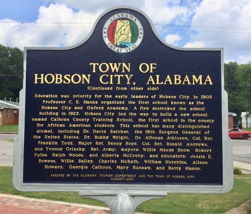
Front
Hobson City is Alabama's first incorporated black city. The area was first known as Mooree Quarter, a black settlement that was part of Oxford, Alabama. After a black man was elected Justice of the Peace in Oxford, one mayor . . . — — Map (db m106598) HM
The Chief Ladiga Trail was named for a Creek Indian leader who signed the Cusseta Treaty in 1832. Under the terms of that agreement, the Creeks gave up claim to their remaining lands in northeast Alabama. Because he had signed the treaty, Ladiga was . . . — — Map (db m36438) HM
Jacob Forney III lived and operated a thriving mercantile establishment at Jacksonville from 1835-56 on the south-east corner of the square. He and his wife Sabina Swope Hoke were the parents of nine children.
1. Daniel Peter - b. Feb. 24, 1819, . . . — — Map (db m36450) HM
Postoffice established July 20, 1833 as Drayton, Benton County, Alabama. Name changed to Jacksonville Aug. 6, 1834 and county changed to Calhoun Jan. 29, 1858. Office maintained by Confederate Government 1861-1865.
Postmasters and dates of . . . — — Map (db m36449) HM
Town first called Drayton.
Renamed in 1834 to honor
President Andrew Jackson.
Seat moved to Anniston in 1899.
Calhoun Co. originally was Benton Co.,
for Col. T. H. Benton, Creek War officer,
later U. S. Senator from Missouri.
. . . — — Map (db m36471) HM
Life here has long centered on education beginning in 1834 when a one-acre plot of land was reserved for a schoolhouse. Through the years, various institutions of higher learning developed that culminated into present-day Jacksonville State . . . — — Map (db m36429) HM
In 1905, local businessman Henry P. Ide joined with out-of-state investors and built the Ide-Profile Cotton Mill. Along with the mill, the company established the Profile Mill Village, which originally began as 40 homes for workers. The company . . . — — Map (db m195730) HM
Profile Cotton Mills Historic District has been placed on the National Register of Historic Places in 2006 by the United States Department of the Interior — — Map (db m195728) HM
The Archaic period covers a vast expanse of time (8,250 years).
Many changes occurred during the Archaic period. For
example, the climate and vegetation that Early Archaic people
saw was much different than the climate and vegetation that
Late . . . — — Map (db m160554) HM
First incorporated as a town, February 7, 1852, in Benton County, Oxford's second incorporation was approved February 21, 1860 in Calhoun County. Long before this territory was “settled”, it was inhabited by Creek Indians. In the time . . . — — Map (db m106589) HM
Welcome! We are the Arbeka (Abihka). This is the ceremonial
ground of our ancestors who once called this valley their home.
When the Arbeka (Abihka) were forced to remove to Oklahoma
they carried the sacred fire from this place to their new home. . . . — — Map (db m144923) HM
The stone mound here once sat on nearby Signal Mountain and is now
understood to be part of a much larger cultural landscape. Working with
the Muscogee (Creek) Nation and the people of the Arbeka (Abihka)
Ceremonial Ground, archaeologist Robert . . . — — Map (db m144927) HM
The town of Oxford was first incorporated by the Alabama legislature in 1852. The original boundaries included a one square mile area enlarged in 1860. Oxford became active as a cotton and trading center but during the Civil War growth slowed, and . . . — — Map (db m106591) HM
Centered around Boiling Spring, the Choccolocco Creek Archaeological Complex once consisted of at least three earthen mounds, a large stone mound, and a large snake effigy (representation) also made of stone. The largest earthen mound once stood . . . — — Map (db m144926) HM
Located at the end of McKibbon Street is on a cedar covered hill with a beautiful view. The cemetery contains the remains of many of Oxford's early settlers. Some markers date in the 1850's. — — Map (db m195727) HM
Today, the people who once inhabited this region of Alabama are recognized
by the federal government as belonging to several tribes: the Muscogee
(Creek) Nation, Alabama-Quassarte Tribal Town, Kialegee Tribal Town, and
Thlopthlocco Tribal Town of . . . — — Map (db m144937) HM
Woodland period people established permanent communities
within a climate and forest that was very similar to that
experienced by today's residents of the Choccolocco Valley. By
AD 100, the residents had started constructing the earthen
mound . . . — — Map (db m144977) HM
Cross Plains citizens voted for incorporation March 10, 1871. A second vote was cast for reincorporation May 15, 1882. By the acts of the Alabama Legislature of 1888, Cross Plains became Piedmont September 30, 1888. Mayors for both Cross Plains . . . — — Map (db m272389) HM
Hiram Dugger came to Benton County, Alabama, in 1832 from Carter County, Tennessee, before the Indians were removed to the west. He worked a year for Joseph Nolen before marrying Mr. Nolen's daughter, Zanna. The couple moved to the base of the . . . — — Map (db m270859) HM
Following the signing of the Creek Treaty in 1832, the early white settlers constructed a 16 by 30 foot hand hewn log fort for protection against a possible Indian uprising from Cussetaw Indian Village on Osanippa Creek just north of here. Walls of . . . — — Map (db m71643) HM
In 1885, Five Points was named because of five roads converging at a single point. Before this, the post office was known as Lystra, operated by Postmaster W.C. Smith. The town was incorporated in 1915, making the town Chambers County's oldest . . . — — Map (db m195788) HM
From its foundation, Fredonia was the educational and trade center for northeast section of Chambers County. "The Southern Military Academy" was established in the village by the state legislature and forced to close by the civil strife. Sixteen . . . — — Map (db m197957) HM
Chambers County, created December 18, 1832 from Creek Indian cession. Named for Dr. Henry C. Chambers of Madison County, member of Constitutional Convention 1819, legislature of 1820, elected U.S. Senator 1825 but died enroute to Washington.
. . . — — Map (db m18162) HM
This structure was built by early settlers from Virginia, Tennessee, and the Carolinas, and subsequently modified. The original building has stood since 1836.
Union Sunday School begun here in 1891. Many eminent ministers have filled the . . . — — Map (db m83264) HM
Known as Bluffton from about 1835-1893. Bluffton was incorporated in 1865. Name changed to Lanett, town of Lanett incorporated 1893. Its charter was approved in 1895. Early records mention academies, two near this site. The Presbyterian Church was . . . — — Map (db m92061) HM
This general area is believed to be the site of the Indian village of Costa visited by DeSoto July 2, 1540. The very old cedar trees may have been here at that time. They are some of the largest in the Southeast. These cedars are among the . . . — — Map (db m114988) HM
Area 575 square miles. Aborigines inhabited area 4000 B.C. Cherokee and Creek Historic Indians about 1300-May 1838. Hernando De Soto-First white man July 1540. First white settlers about 1810 from VA, NC, SC, GA, and Tenn. Formed Cherokee Cession . . . — — Map (db m133321) HM
This area had long been home to the Cherokee Indians and the first white settlers did not arrive until the early 1800's. On December 29, 1835, the Cherokees signed a controversial treaty surrendering their lands here to the U.S. Government. A short . . . — — Map (db m114840) HM
The McClung brothers, J.B. and Thomas, homesteaded land on Johhny's Creek in the 1800s. The two brothers harnessed power from water that flowed over the falls to operate a sawmill and grist mill. The McClung's two mills and blacksmith shop played . . . — — Map (db m212844) HM
Mose Hampton bought his freedom prior to the Civil War. He was a builder, assisted in laying out and surveying the town of Centre, a minister in the Episcopal Methodist North, and an inventor. Mr. Hampton owned land in the vicinity of this marker on . . . — — Map (db m120046) HM
One hundred feet east was one site where "The Trail of Tears" began. On May 23, 1838 the Indians of this general area, who had been held in a chestnut log stockade after being gathered by the U.S. Army, began their long trek to Oklahoma.
The . . . — — Map (db m114398) HM
Post Office est. in 1836. During the Civil War, the main body of U.S. General William Tecumseh Sherman's Army camped around the town in October 1864. A private home served as his headquarters. Despite pleas from citizens, his troops burned the mill . . . — — Map (db m114532) HM
Cherokee County established - 1836
Area Cherokee Indians relocated - 1838
Taff Community established - 1842
Community named in honor of Taff family - 1842
Union and Confederate soldiers occupied the area - 1864
Taff post office established . . . — — Map (db m114743) HM
The town's name was derived from the name of the Henslee Family which were early settlers in the community. A post office was established in 1837. The Rome & Decatur Railroad (later Southern Railway) began rail service through the town in 1888. . . . — — Map (db m261856) HM
In 1835, pioneering families migrated from Morgan County, Georgia to Cherokee County, AL, settling in the Ambersonville area, later renamed Spring Garden. These families were members of Carmel Presbyterian Church in Morgan County and brought their . . . — — Map (db m132792) HM
Located 500 yards southeast of this marker. Incorporated in 1888, Bluffton was promoted as a future iron center of the South, due to large iron ore deposits and four furnaces within a four mile radius. The town soon boomed due to an influx of . . . — — Map (db m140001) HM
Was originally named Ambersonville after one of the early families that settled the community. A post office was established in 1842 as Liberty and changed to Spring Garden in 1844. The Selma, Rome and Dalton Railroad began rail service through the . . . — — Map (db m114959) HM
Clanton, originally named Goose Pond, was founded in 1867 by Alfred Baker Sr. Goose Pond was renamed Clanton in honor of Confederate hero General James Holt Clanton. The city limits cover approximately 18 square miles. Clanton is located near the . . . — — Map (db m54979) HM
Founded in 1895, the Town of Thorsby was the first planned community in Chilton County. The original settlers were people of Scandinavian origin seeking a favorable climate to locate for farming, fruit growing and better health. The original . . . — — Map (db m73231) HM
This cemetery is the final resting place for thirty-seven
members of the Moore Family. John Moore, son of American
Revolutionary War Patriot and Battle of Charleston POW
Obadiah Moore, purchased this land on September 4, 1834.
The Moore family . . . — — Map (db m206684) HM
The only community in the U.S. so designated, Verbena was named for the profuse wild flowers growing in the area. Settlers arrived in the area as early as 1832. Completion of the North-South Railroad and a train depot at Verbena in 1870 enabled . . . — — Map (db m68286) HM
This 4000 acre complex has been recognized for its contribution to our understanding of the history of Monroe County and the State of Alabama. Originally developed as a cotton plantation during the Antebellum period, this farm has been in continuous . . . — — Map (db m80345) HM
The town of Coffeeville began in 1808 as Murrell's Landing, a boat
landing and ferry crossing on the Tombigbee River. William Murrell
was a landowner and state representative for Clarke County. By
1819, the town had been renamed in honor of . . . — — Map (db m285143) HM
This marker stands inside the Mitchell Reserve, created Nov. 16, 1805 by the Treaty of Mount Dexter between the Choctaw Nation & the United States. The Reserve begins at a "post on the left bank of the Tombigbee River opposite the lower end of . . . — — Map (db m244880) HM
Founded in 1809 by George Strother Gaines as Choctaw-Creek Indian Trading Post on Alabama River, now Gainestown Landing. Here lived Alabama Indians for whom State & River named. At Battle of Maubila De Soto's hogs escaped, from whence . . . — — Map (db m101609) HM
Side 1
Near this spot are the graves of American Revolution soldier Elijah Pugh and his son Issac, a War of 1812 veteran. Elijah, born in Guilford Co., N.C. in 1760, was 18 when he joined a patriot band led by Col. Elijah Clarke at the . . . — — Map (db m154482) HM
Grove Hill, first inhabited by Choctaw Indians, was settled by pioneers in the early 1800s. The settlement was called Magoffin's Store after James Magoffin whose shop, two miles from the present courthouse, opened in 1815. Grove Hill has also . . . — — Map (db m47653) HM
Side 1
First home of Creek and Choctaw Indians, Jackson’s first pioneer settlers arrived about 1800. The little village was first called Republicville, then Pine Level, before its incorporation by an act of the Mississippi Territory . . . — — Map (db m101591) HM
First village called Republicville. Town laid out in 1815 by Pine Level Land Company and named Pine Level. Incorporated 1816 and renamed Jackson for General Andrew Jackson. First commissioners, David Taylor, David White, Reuben Saffold, Peregrin . . . — — Map (db m101589) HM
The area from Stave Creek to Jackson Creek was one of sites for the making of salt during the years 1862-64.
Furnaces of native stone were built and salt water from dug wells evaporated by boiling in large kettles.
Amount of salt six hundred . . . — — Map (db m101607) HM
These springs, once called the “celebrated watering place,” believed at one time to have numbered seventeen, all in an area smaller than a baseball diamond, are about ¼ mile south from this point at the headwaters of Tallahatta Creek.
They and . . . — — Map (db m203671) HM
Side 1
In the summer of 1887, a notice was published confirming that the route for the Mobile and West Alabama Railroad would be the Choctaw Corner route. Soon the sounds of building could be heard over the swamp that was the . . . — — Map (db m101601) HM
Settled 1809-1820 in what was Mississippi Territory. Alabama became a state Dec. 14, 1819. Early settlers — Turner-Thornton-Stringer-White-Scruggs-Pace-May. Turner's fort built 1812, located 1½ miles N. W. West Bend Academy est. 1859 and located . . . — — Map (db m203667) HM
Town laid out in 1819 at crossing of Old Line and Old Federal Roads. Named for Wm. Suggs, storekeeper. Site of Clarke County's first newspaper, cotton gin, carriage, shoe and silk factory. Site of extensive aviation experiments by Dr. Denny 100 . . . — — Map (db m47698) HM
Front
Originally home to Creek and Choctaw Indians, Whatley was first settled by pioneers about 1808. Some of the most famous events in Clarke County’s history happened in or near Whatley. A Creek War battle occurred here in 1812 at Fort . . . — — Map (db m110971) HM
Side 1
Clay County was formed by an act of the Alabama General Assembly on December 7, 1866. Less than a year later, Ashland was established as the county seat on land donated by Hollingsworth Watts for the construction of a . . . — — Map (db m95087) HM
Side 1
Clay County and the
Creek Indian War of 1813-14
During the Creek Indian War of 1813-14, a subset of the War of 1812 with England, numerous figures prominent in American history marched over what would become Clay . . . — — Map (db m95100) HM
Side 1
Union Baptist Church. later named the First Baptist Church of Ashland, was founded with 23 charter members in 1865, six years before the town was incorporated. Members met in a log cabin in the southwestern part of Ashland. From . . . — — Map (db m95101) HM
The forests near Cheaha have been inhabited for thousands of years. Trade
routes brought other native and non-native people to the area searching for
ore, gemstones, venison, hides, furs, honey, beeswax, hickory nut oil, and
other medicinal and . . . — — Map (db m175335) HM
Native Americans were the first to inhabit the area known as
Lineville. The Creek Indian War of 1812, however, resulted in their
removal. The first white settlers here were William and Thomas
Lundie. Their settlement became known as Lundie's . . . — — Map (db m175281) HM
This historic site marks the first
settlement known as "Lundie's
Crossroads" settled in 1838. The name
changed to "County Line" in 1856. Clay
County was formed on this line from
Randolph and Talladega Counties in
1866. The . . . — — Map (db m95103) HM
The first of three Baptist Churches was built on
this site about 1842 as white pioneer settlers
increased. The present building was constructed
about 1895. The only surviving church book,
begun in 1898, shows sixty-eight male and
seventy-six . . . — — Map (db m288228) HM
In the 1830s, a group of people from Edgefield, South Carolina
settled in the lowlands of what is now Cleburne County. Among
them were Frederick Ross and John and Nancy Ross. John and
Nancy had 13 children, some of whom were born in . . . — — Map (db m285178) HM
Elba began circa 1840. A ferry had been started across Pea River, thus beginning the town’s first name, Bridgeville. In 1850, the town’s name was changed to Bentonville in honor of a Missourian who had distinguished himself in service to Alabama in . . . — — Map (db m54201) HM
The first Coffee County Courthouse was at Wellborn and burned in 1851. This site given by John B. Simmons when Elba was selected the county seat polling 58 more votes than Indigo Head (Clintonville) in a county election on October 5, 1852. The first . . . — — Map (db m54804) HM
The first seat of justice for Coffee County was located approximately 500 yards southeast of this site. The community was named for Gen. William Wellborn, an Alabama commander during the Creek Indian War of 1836-37.
Under the Act of December . . . — — Map (db m95355) HM
Established here about 1871 and served as educational, cultural, religious and social center of this community until consolidation in 1934. School land was donated by George and Georgie Arwood. Early teachers included W.E. Andrews, Mrs. M.E. Fleming . . . — — Map (db m95354) HM
was moved by Benjamin Smith from Pontotoc, Miss. in 1825 to this site, known as Bennkhinnah, where it remained until 1837. Bennkhinnah Post Office, established at the Agency in 1829, was renamed Newport in 1837. In 1856 with D. C. Oates as . . . — — Map (db m156992) HM
Side 1 By 1805, half-blood Chickasaw leaders George and Levi Colbert were operating inns and a river ferry nearby on the Natchez Trace. The Chickasaw Indian Agency was moved to Agency Creek, now Malone Creek, (3.8 miles east) in 1825. Caney . . . — — Map (db m41132) HM
Frontier America once walked along the Natchez Trace.
The Chickasaw and Choctaw used the Trace for transportation and trade. After 1801, with tribal permission, post riders who rode the Trace connected isolated settlements in Mississippi and . . . — — Map (db m107257) HM
In the early 1820s, wealthy landowners in the Leighton, Alabama, area established a village on the crest of the mountain to the southwest of this site. This community eventually had about 400 inhabitants and became known as LaGrange. In the 1820s, . . . — — Map (db m141747) HM WM
(side 1)
After LaGrange College moved to Florence in January 1855, a group of LaGrange citizens organized a college in the vacant buildings under the old name. Rev. Felix Johnson was elected president. To increase the patronage, a . . . — — Map (db m278612) HM
FrontByler Road
Pioneer's settled path to new lands, agriculture, transport and commerce that began in Northwest Alabama.
140 mile corridor/route designated on December 19th, 1819 by the State Legislature. This was . . . — — Map (db m205287) HM
Side 1
Leighton developed at the intersection of the Byler Road (1819) and
the Tuscumbia - Courtland Stage Road (1820), where the Jeffers/Gregg
Tavern served the needs of travelers as early as 1810. Leighton was
named for William . . . — — Map (db m153259) HM
Baldy Shaw purchased this property from the state of Alabama in 1830. In 1844, he constructed this home. Over the years, various property owners made changes and addition to the Shaw Home and its outbuildings. The canning building is directly north . . . — — Map (db m209816) HM
The town of Leighton was named in honor of the Reverend William Leigh, son and grandson of Revolutionary War veterans. He was born in Amelia County Virginia, Oct 4, 1790 and moved to Alabama about 1823. Leigh settled nearby at “Jeffers Cross . . . — — Map (db m278611) HM
(side 1)
Capt. Benjamin F. Little, a former Confederate soldier, opened a store here after the railroad from Tuscumbia to Russellville was built in 1887. A train station and several houses were soon erected. A rail spur provided access to . . . — — Map (db m68954) HM
The town of Bainbridge was located at the head of navigation on the Tennessee River. The first state highway called the Byler Road was built through Bainbridge. A ferry was located here where the water was deep and the current not as strong as other . . . — — Map (db m205286) HM
The city of Muscle Shoals began with the construction of U.S. Nitrate Plant No.2 and Wilson Dam for defense purposes in 1918. The name came from the great stretch of rapids in the Tennessee River that contained rocky shoals and an abundance of . . . — — Map (db m83388) HM
Marker Front:
Muscle Shoals City was incorporated on April 24, 1923. Among the leading developers were New York realtors A.L. Howell and C.T. Graves. Their interest in Muscle Shoals was inspired by the vision of Henry Ford to use power from . . . — — Map (db m28580) HM
Side A Prehistoric man arrived in this area bout 10,000 years ago.
Later Indian cultures left many stone artifacts and pottery vessels.
In the 1780s, a French trading post and Indian village were located near the mouth of Spring Creek. . . . — — Map (db m83389) HM
Side 1
Oka Kapassa (Ococoposa), meaning "Cold Water", was the Chickasaw name given to Spring Creek and to a trading post established near the Tennessee River about 1780. About 1817, Michael Dickerson and others were greeted at what by . . . — — Map (db m83393) HM
First Presbyterian Church was organized April 13, 1824, by Scots-Irish settlers. The sanctuary, erected in 1827, is the oldest in continuous use in Alabama. Its Georgian Gothic style remains essentially unchanged. The brick walls are laid in . . . — — Map (db m40429) HM
(Obverse):
The area around the Big Spring was inhabited by prehistoric Native Americans as early as 10,000 years ago. The first settlement was a French trading post and Indian village about 1780 on Cold Water Creek (Spring Creek) near the . . . — — Map (db m83396) HM
The Family Home of Captain Arthur M. & Kate Adams Keller was built 1820, being the second house erected in Tuscumbia.
Here on June 27, 1880 was born America's First Lady of Courage Helen Adams Keller.
This Property has been placed on . . . — — Map (db m29089) HM
Big Spring (average daily flow 35,000,000 gallons) provided water for town founded on its banks.
Michael Dickson of Tennessee was first settler (about 1817). Town laid out in 1819 and incorporated as Ococoposo (Cold Water, 1820).
Name changed to . . . — — Map (db m83453) HM
A settlement originally located at the mouth of Ard and Bottle Creek, three miles northwest of the current site, is one of the oldest communities in Conecuh County. Brooklyn was founded by Edwin Robinson in 1820 and named for his hometown in . . . — — Map (db m193084) HM
The first known school in Conecuh County, "Students Retreat," was located near this site. The land was owned by John Green, who also was the school’s first teacher. Green served the county in the state House of Representatives and the 1861 Secession . . . — — Map (db m81295) HM
War of 1812 veteran John Green (1790-1882) settled in Burnt Corn in 1816. He held many public offices, established the first school, and represented Conecuh County in the state legislature in 1824 and 1829. He was the Conecuh delegate to the . . . — — Map (db m81285) HM
Garrett Longmire had an early trading center, tavern and stage stop near here. He served as the postmaster when his store became a post office in 1818, one of the earliest in what was then the Alabama Territory. The Burnt Corn Post Office served as . . . — — Map (db m81298) HM
In the fall of 1817 Reverend Alexander Travis settled his affairs in South Carolina and immigrated to Conecuh County, where, in the spring of 1818, Beulah Baptist Church was constituted. In rapid succession, Travis’ firm resolve and his devotion to . . . — — Map (db m86270) HM
Evergreen, the county seat of Conecuh County, is located in the central part of the county on the Louisville & Nashville Railroad. Founded in 1819 by James Cosey, George Andrews and the Clough Brothers, Evergreen was originally known as "Cosey’s . . . — — Map (db m81287) HM
Side 1
Doctor Reverend Hillary James Hawkins, who was affectionately known throughout the community as “Brown,” dedicated most of his adult life to providing spiritual guidance to blacks in Evergreen and surrounding . . . — — Map (db m81292) HM
Midway was one of the first settlements established in Conecuh County along the Post Road which later became the Old Federal Road. Long serving as a hub for Indian trails branching out to the north, northeast and northwest, the Midway town site once . . . — — Map (db m81277) HM
Stephen Decatur Miller Jr., namesake of a former governor and U.S. Senator from South Carolina, moved to rural Conecuh County in 1850. He brought with him to this place at least thirteen enslaved people. Within a decade, farming interests enriched . . . — — Map (db m305848) HM
Immigrants from South Carolina settled in this area of Conecuh
County in the 1870s. As the local population increased, residents
needed a local post office. David Robinson submitted a petition to
the U.S. Postal Service requesting a post office . . . — — Map (db m167702) HM
In the early 1900s, Repton was a bustling railroad town along the Louisville and Nashville Railroad. Among other businesses, it boasted several hotels, banks, stores, a livery stable, cotton gin and the only hospital with a Board Certified . . . — — Map (db m100840) HM
Duncan MacMillan’s stage stop was located near here. According to traveler James Stuart in 1830, he (Duncan) “did not taste fermented liquor” and “thought coffee was the best stimulant.” Mr. McMillan came from Scotland and like many early settlers . . . — — Map (db m81278) HM
Although the Creek Indians retained ownership of this territory after the Treaty of Fort Jackson ended the Creek War of 1812-14, whites began settling here before Alabama achieved statehood. This site included a Native American village, frontier . . . — — Map (db m96064) HM
41410 entries matched your criteria. Entries 101 through 200 are listed above. ⊲ Previous 100 — Next 100 ⊳