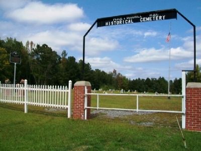
By William Fischer, Jr., October 7, 2012
Peace & Goodwill Cemetery and Marker
| On Alabama Route 22 west of Route 9, on the right when traveling west. |
| On Historical Central Street at Tisdale Street, on the right when traveling east on Historical Central Street. |
| On North Court Square at Crescent Street, on the right when traveling west on North Court Square. |
| On 5th Street at 5th Avenue (U.S. 331) on 5th Street. |
| On River Falls Street (U.S. 84) 0.2 miles east of Heath Road (County Route 70), on the right when traveling east. |
| Near County Road 67 at U.S. 84, on the right when traveling west. |
| On Dozier Highway (U.S. 29) 0.1 miles south of School Street, on the right when traveling south. |
| On Dozier Highway (U.S. 29) 0.1 miles north of Sports Road, on the right when traveling north. |
| On U.S. 331 north of 9th Street, on the right when traveling north. |
| On School House Circle at Community House Rd, on the right when traveling north on School House Circle. |
| On Lee Street (State Road 10) at North Watts Avenue, on the right when traveling west on Lee Street. |
| On County Road 747 at County Road 1616, on the right when traveling north on County Road 747. |
| On 3rd Street Northeast (U.S. 278) at 4th Avenue Southeast, on the right when traveling east on 3rd Street Northeast. |
| Near 9th Street Southeast at Main Avenue Southwest. |
| On Arnold Street NE close to 2nd Street NE, on the right when traveling west. |
| On 4th Street Southwest at 5th Avenue Southwest, on the right when traveling east on 4th Street Southwest. |
| On County Road 747 0.1 miles south of County Road 1508, on the left when traveling south. |
| On 2nd Avenue Southeast north of 6th Street Southeast, on the right when traveling north. |
| On 1st Avenue Southeast at 4th Street Southeast, on the right when traveling south on 1st Avenue Southeast. |
| On Main Street Northeast (U.S. 31) south of Arkadelphia Road (State Route 91), on the right when traveling south. |
| On New Hope Road (County Road 1809) 0.2 miles south of County Road 1816, on the right when traveling south. |
| On County Road 846 north of County Road 844, on the right when traveling north. |
| On Clio Road (State Highway 51) at Powell Circle, on the right when traveling east on Clio Road. |
| On Alabama Route 85 at Auburn Parker Road, on the right when traveling south on Alabama Route 85. |
| On South Daleville Avenue (Alabama Route 85) south of Jennifer Lynn Drive, on the right when traveling south. |
| On Joe Bruer Road (County Road 114) at Elna Street, on the right when traveling west on Joe Bruer Road. |
| On Alabama Route 134 at Parramore Road, on the right when traveling east on Alabama Route 134. |
| On U.S. 231 0.6 miles north of County Road 14, on the right when traveling north. |
| On College Street (Alabama Route 134) at Queen Street, on the right when traveling south on College Street. |
| On Andrews Avenue (Alabama Route 249) west of Meadowlake Drive, on the right when traveling west. |
| On South Union Street, on the right when traveling north. |
| On South Union Avenue (Alabama Route 123) north of Reynolds Street, on the left when traveling north. |
| On Unnamed road west of Myrtle Drive, in the median. |
| On County Road 33, on the right when traveling north. |
| On State Road 22 at County Route 9, on the right when traveling west on State Road 22. Reported missing. |
| On Oak Street south of First Street South, on the right when traveling south. |
| On Capitol Avenue near Vine Street, in the median. |
| Near Vine Street south of Capitol Avenue. |
| On Capitol Street at Cahaba Road, on the right when traveling east on Capitol Street. |
| On Vine Street, on the right when traveling north. Reported permanently removed. |
| On Second Street North at Vine Street, on the left when traveling west on Second Street North. |
| On Vine Street south of 2nd Street North, on the right when traveling north. |
| On Vine Street 0.1 miles south of Capitol Street, on the left when traveling south. |
| On Oak Street (County Road 155), on the left when traveling north. Reported permanently removed. |
| On Mulberry Street south of First South Street, on the left when traveling south. |
| Near Cahaba Road at Capitol Street, on the right when traveling north. Reported permanently removed. |
| On Oak Street, on the right when traveling south. |
| Near Cahaba Road, on the right when traveling north. |
| On 6th South Street. Reported permanently removed. |
| On 1st Street North, on the left when traveling west. Reported permanently removed. |
| On Vine Street at 1st Street North, on the right when traveling south on Vine Street. |
| On Capitol Street, on the right when traveling east. Reported permanently removed. |
| On Vine Street, on the left when traveling south. Reported permanently removed. |
| Near 2nd Street North. Reported permanently removed. |
| On Oak Street north of Fifth North Street, on the left when traveling north. |
| Near Second North Street east of Vine Street. |
| On Vine Street at Capitol Avenue, on the right when traveling north on Vine Street. |
| Near 2nd Street North near Vine Street. Reported permanently removed. |
| On Vine Street at Capitol Avenue, on the right when traveling north on Vine Street. Reported permanently removed. |
| On Vine Street at Capitol Street, on the right when traveling north on Vine Street. Reported permanently removed. |
| On Vine Street at Capitol Street, on the right when traveling north on Vine Street. |
| On Capitol Street east of Cahaba Road, on the right when traveling east. |
| Near Oak Street south of 1st Street North. |
| On Capitol Street at Walnut Street, on the right when traveling west on Capitol Street. |
| On Main Street (Alabama Route 22) east of Church Street South. |
| On Union Street at McLeod Avenue, on the left when traveling south on Union Street. |
| On Martin Luther King Jr. Street north of St. Johns Street, on the right when traveling north. |
| On Broad Street (U.S. 80), on the right when traveling north. |
| On Kings Street south of Dallas Avenue (State Highway 22), on the right when traveling south. |
| Near County Road 16 0.4 miles west of Alabama 22, on the right when traveling west. |
| On Alabama Route 22 south of Old Stage Road, on the right when traveling north. |
| On West Main Street, on the right when traveling east. |
| On East Main Street, on the left when traveling east. |
| On Alabama Route 68, on the right when traveling west. |
| On Main Street (Alabama Route 68) at Gaines Street, on the right when traveling east on Main Street. |
| On Grand Avenue Northwest at 3rd St NW, on the right when traveling south on Grand Avenue Northwest. |
| Near Little River Falls Overlook Trail 0.1 miles west of State Road 35. |
| On County Road 52 at County Road 293, on the left when traveling west on County Road 52. |
| On Alabama Route 75 0.1 miles east of Main Street ( Route 227), on the right when traveling north. |
| On State Highway 117, on the right when traveling north. |
| Near Interstate 59 1 mile north of County Road 140, on the right when traveling south. |
| On Winston Street at Sulphur Springs Road, on the right when traveling north on Winston Street. |
| On Holtsville Road (State Road 111) west of Coosa River Road, on the right when traveling west. |
| On Monument Drive 0.1 miles west of Main Street ( Route 143), on the right when traveling west. |
| On Tukabatchee Road (State Highway 229) at Taylor Road, on the right when traveling south on Tukabatchee Road. |
| On West Fort Toulouse Road 0.1 miles west of U.S. 231, on the right when traveling west. |
| Near West Fort Toulouse Road 0.3 miles west of Jackson Park Road, on the right when traveling west. |
| On Weoka Road (County Road 211) south of Grier Road, on the right when traveling south. |
| Near West Fort Toulouse Road 0.6 miles west of Jackson Park Road. |
| Near East Commerce Street at Court Street, on the right when traveling east. |
| On Dixon Center Road 1.6 miles north of U.S. 29, on the right when traveling north. |
| On U.S. 31 at Baker Street, on the right when traveling east on U.S. 31. |
| On East Nashville Avenue (U.S. 31) 0.1 miles west of Presley Street, on the right when traveling west. |
| On Damascus Road at Well Road (County Route 71), on the right when traveling east on Damascus Road. |
| On Sidney E Manning Blvd (U.S. 29) at Houston Street, on the right when traveling north on Sidney E Manning Blvd. |
| On Butler Road (County Road 45) 0.1 miles south of Neuschwander Road, on the right when traveling south. |
41684 entries matched your criteria. Entries 201 through 300 are listed above.
⊲ Previous 100 —
Next 100 ⊳
