After filtering for Utah, 548 entries match your criteria. The first 100 are listed. ⊳
Settlements & Settlers Topic
By Jeremy Snow, October 14, 2023
The Grist Mill Marker
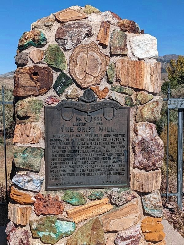
| 1 ► Utah, Beaver County, Adamsville — 255 — The Grist Mill — |
| On West 1100 South, on the right when traveling west. | |||
| 2 ► Utah, Beaver County, Beaver — Early Sawed Log Farm Cabin — (circa 1890-1900) — |
| On East Center Street (Utah Route 21) east of Main Street (Utah Route 160), on the right when traveling east. | |||
| 3 ► Utah, Beaver County, Beaver — 68 — Lee’s Ranch Indian Raid — |
| On Main Street (U.S. 91), on the left when traveling south. | |||
| 4 ► Utah, Beaver County, Beaver — 147 — Pioneer First Camp Ground — |
| On South Main Street, on the right when traveling north. | |||
| 5 ► Utah, Beaver County, Beaver — Pioneer Park — |
| On North 400 East Street south of East 400 North Street, on the right when traveling north. | |||
| 6 ► Utah, Beaver County, Cove Fort — Fort Willden — A Farm and Way Station — |
| Near Utah Route 164, 1 mile north of Interstate 70. | |||
| 7 ► Utah, Beaver County, Frisco — 268 — Frisco — |
| On Ely Highway (Utah Route 21), on the left when traveling north. | |||
| 8 ► Utah, Beaver County, Milford — 91 — Milford Stamp Mill — |
| On South 100 West Street, on the right. | |||
| 9 ► Utah, Beaver County, Minersville — 17 — The Lincoln Mine — First lead mine in Utah — |
| On Main Street at N 100 W Street, on the right when traveling west on Main Street. | |||
| 10 ► Utah, Box Elder County, Beaver Dam — 334 — Hansen Cooperative Dairy — |
| On West Beaver Dam Road, on the left when traveling west. | |||
| 11 ► Utah, Box Elder County, Brigham City — 482 — A Pioneer Home — |
| On West Forest Street. | |||
| 12 ► Utah, Box Elder County, Brigham City — 55 — Box Elder Fort — |
| On 275 North 200 West. | |||
| 13 ► Utah, Box Elder County, Brigham City — 74 — Brigham City Co-Op — |
| On West Forest Street. | |||
| 14 ► Utah, Box Elder County, Brigham City — 22 — Call's Fort — |
| On Highway 69, on the right when traveling south. | |||
| 15 ► Utah, Box Elder County, Brigham City — 69 — Erected in Honor of Brigham Young — |
| On Forest St, on the left when traveling east. | |||
| 16 ► Utah, Box Elder County, Brigham City — 148 — Historic Brigham City Relief Society Granary — |
| On East 100 North at North 400 East, on the right when traveling east on East 100 North. | |||
| 17 ► Utah, Box Elder County, Brigham City — Lorenzo Snow Burial Site — |
| On East 300 South on East 300 South. | |||
| 18 ► Utah, Box Elder County, Brigham City — 25 — Pioneer Care Center — |
| On South 200 West, on the left when traveling south. | |||
| 19 ► Utah, Box Elder County, Brigham City — 1 — The Davis Fort-Built 1851 — Brigham City Historic Tour — |
| On 400 West 700 North at 400 W 700 N, on the right when traveling east on 400 West 700 North. | |||
| 20 ► Utah, Box Elder County, Corinne — BBU-7 — Bidwell/Bartleson Trail - Monument Point — First Overland Emigrant Party — |
| On Transcontinental Railroad Back Country Byway, on the right when traveling west. | |||
| 21 ► Utah, Box Elder County, Corinne — Corinne - Pioneer Railroad Town — |
| On Promontory Road (Utah Route 13) 0.1 miles south of North 3900 West, on the right when traveling south. | |||
| 22 ► Utah, Box Elder County, Honeyville — 10 — In Honor of James Bridger — 1804 - 1881 — Early Western Fur Trapper, Frontiersman, Scout and Guide — |
| On 5200 West, on the right when traveling north. | |||
| 23 ► Utah, Box Elder County, Lucin — Lucin — |
| On Grouse Creek Road, 0.2 miles north of Tucoma Road, on the left when traveling south. | |||
| 24 ► Utah, Box Elder County, Perry — 439 — Three Mile Creek Settlement — |
| On Elm Grove Dr. south of W 2400 S, on the right when traveling north. | |||
| 25 ► Utah, Box Elder County, Snowville — 435 — Curlew Valley — |
| On North Stone Road, on the left when traveling south. | |||
| 26 ► Utah, Box Elder County, Willard — 48 — North Willow Creek Fort — |
| On S 100 W at South Street, on the right when traveling north on S 100 W. | |||
| 27 ► Utah, Box Elder County, Willard — 507 — Willard Pioneer Cemetery — |
| On North Main Street at W 300 N, on the right when traveling north on North Main Street. | |||
| 28 ► Utah, Cache County, Hyde Park — In Memory Of The Hyde Park Settlers — |
| On Center Street at 200 West, on the left when traveling east on Center Street. | |||
| 29 ► Utah, Cache County, Hyrum — Hyrum Smith — Feb. 9, 1800 — June 27, 1844 — |
| On West Main Street (Utah Route 101) west of South Center Street, on the left when traveling west. | |||
| 30 ► Utah, Cache County, Hyrum — 55 — The Great Fur Cache — |
| On West Main Street (Utah Route 101) west of South Center Street, on the left when traveling west. | |||
| 31 ► Utah, Cache County, Logan — 5 South Main — Thatcher Brothers Bank & Opera House — Logan Historic Site — |
| On Main Street at Center Street, on the left when traveling north on Main Street. | |||
| 32 ► Utah, Cache County, Logan — 75 South Main — Utah Historic Site — |
| 33 ► Utah, Cache County, Logan — 9 — Cache County Relic Hall — |
| On 100 W 100 S. | |||
| 34 ► Utah, Cache County, Logan — Julia Budge Nibley House — Logan Historic Site — |
| On W. Center Street at S 300W on W. Center Street. | |||
| 35 ► Utah, Cache County, Logan — 63 — Logan Community Center — |
| On 400 East, on the right when traveling north. | |||
| 36 ► Utah, Cache County, Logan — 174 — Pioneer Mills of Cache Valley — |
| On Main St., on the right when traveling north. | |||
| 37 ► Utah, Cache County, Logan — Thatcher-Young Mansion — |
| On 100 South, on the right when traveling west. | |||
| 38 ► Utah, Cache County, Logan — 9 — The First Settlers of Logan — |
| On Main St., on the right when traveling north. | |||
| 39 ► Utah, Cache County, Mendon — Restoration of the James G. Willie Home — |
| On North 100 West (Utah Route 23) at West 100 North, on the right when traveling south on North 100 West. | |||
| 40 ► Utah, Cache County, Millville — Millville — |
| On 206 W 100 S at 100 S, on the right when traveling east on 206 W 100 S. | |||
| 41 ► Utah, Cache County, Nibley — 68 — Original Church Farm — |
| On West 3200 South west of South 600 West, on the right when traveling west. | |||
| 42 ► Utah, Cache County, Providence — 110 — Providence Pioneers — |
| On 10 S Main, on the right when traveling south. | |||
| 43 ► Utah, Cache County, Providence — The Old Rock Church — |
| On 10 S Main St. at Center St., on the left when traveling south on 10 S Main St.. | |||
| 44 ► Utah, Cache County, Providence — 143 — The Providence Players — |
| On Main Street at Center Street, on the right when traveling south on Main Street. | |||
| 45 ► Utah, Cache County, Richmond — 15 — Richmond Fort — |
| On South 200 West (U.S. 91 at milepost 40) near West Main Street, on the right when traveling north. | |||
| 46 ► Utah, Cache County, Smithfield — In Memory of Ira Elias Merrill — |
| On Main St., on the left when traveling north. | |||
| 47 ► Utah, Carbon County, East Carbon — 272 — Settlement of East Carbon — |
| On U.S. 6 at Utah Route 123, on the right when traveling north on U.S. 6. | |||
| 48 ► Utah, Carbon County, Helper — Helper City — |
| On South Main Street, on the right when traveling north. | |||
| 49 ► Utah, Carbon County, Helper — Pleasant Valley Junction — |
| On U.S. 6 at milepost 217.5, on the right when traveling west. | |||
| 50 ► Utah, Carbon County, Helper — Rainbow Inn — |
| On North Main Street, on the left when traveling west. | |||
| 51 ► Utah, Carbon County, Price — Abraham Powell 1877 Cabin — |
| 52 ► Utah, Carbon County, Price — 197 — First Meeting House — |
| On East Main Street at North 200 East, on the right when traveling west on East Main Street. | |||
| 53 ► Utah, Carbon County, Price — Harding School — |
| On North 200 East. | |||
| 54 ► Utah, Carbon County, Price — 564 — Pioneer Women — |
| 55 ► Utah, Carbon County, Price — 1900 — The Nine Mile Road — |
| 56 ► Utah, Carbon County, Soldier Summit — Soldier Summit - A Failed Experiment — |
| On State Street (Utah Route 6), on the left when traveling east. | |||
| 57 ► Utah, Carbon County, Spring Glen — Frances Marion Ewell — 1835-1905 — First Presiding Elder, Johnson and Black Hawk War Veteran — |
| On U.S. 6 at milepost 234, on the right when traveling south. | |||
| 58 ► Utah, Carbon County, Wellington — Jefferson Tidwell — Early Settlers of Wellington — |
| On Main Street at 100 East, on the left when traveling west on Main Street. | |||
| 59 ► Utah, Carbon County, Wellington — 354 — Pioneer Cabin — |
| On Main Street at 100 East, on the left when traveling west on Main Street. | |||
| 60 ► Utah, Daggett County, Dutch John — William H. Ashley — |
| Near U.S. 191, 7 miles north of State Route 44, on the left when traveling north. | |||
| 61 ► Utah, Davis County, Bountiful — Bountiful Centennial Monument — |
| On North Main Street, on the right when traveling south. | |||
| 62 ► Utah, Davis County, Bountiful — 45 — Daniel Davis — |
| On Orchard Drive at Mill Street, on the right when traveling north on Orchard Drive. | |||
| 63 ► Utah, Davis County, Bountiful — Daniel Wood — Pioneer Founder of Woods Cross, Utah — |
| On South 500 West, on the right when traveling south. | |||
| 64 ► Utah, Davis County, Bountiful — 542 — Daniel Wood Cemetery — |
| On South 500 West, on the right when traveling south. | |||
| 65 ► Utah, Davis County, Bountiful — 44 — Heber C. Kimball — |
| On Orchard Drive at Mill Street, on the right when traveling north on Orchard Drive. | |||
| 66 ► Utah, Davis County, Bountiful — 110 — Jeremiah Willey Cabin — |
| On North Main Street, on the left when traveling north. | |||
| 67 ► Utah, Davis County, Centerville — Kilbourn-Leak House — National Register — Centerville City Historic Site — |
| On North 200 East, on the right when traveling north. | |||
| 68 ► Utah, Davis County, Centerville — 66 — Memorial to Centerville Pioneers — |
| On North Main Street, on the right when traveling north. | |||
| 69 ► Utah, Davis County, Centerville — 93 — The Old Mill — |
| On East 100 South, on the left when traveling west. | |||
| 70 ► Utah, Davis County, Centerville — Thomas & Elizabeth Whitaker House — National Register — Centerville City Historic Site — |
| On North Main Street, on the right when traveling north. | |||
| 71 ► Utah, Davis County, Farmington — Captain Daniel C. Davis — |
| On North Main Street, on the left when traveling south. | |||
| 72 ► Utah, Davis County, Farmington — Clark Lane National Historic District — Utah Historic Site — |
| On West State Street at North 200 West, on the right when traveling west on West State Street. | |||
| 73 ► Utah, Davis County, Farmington — 349 — Pioneer Cabin — |
| Near North 100 West. | |||
| 74 ► Utah, Davis County, Layton — Elias Adams — Settler of East Layton — |
| Near North Eastside Drive (U.S. 89), on the right when traveling north. | |||
| 75 ► Utah, Davis County, Layton — 251 — Stage Coach Station — |
| On South Main Street, on the right when traveling south. | |||
| 76 ► Utah, Davis County, Syracuse — “Our Home So Dear” — |
| Near Antelope Island Road. | |||
| 77 ► Utah, Davis County, Syracuse — Antelope Island — |
| Near West 1700 South. | |||
| 78 ► Utah, Davis County, Syracuse — Historical Wilcox Cabin — William H. & Emily Barber Wilcox — |
| Near 1700 South, on the right when traveling east. | |||
| 79 ► Utah, Davis County, Syracuse — Island Adventures — |
| Near Antelope Island Road. | |||
| 80 ► Utah, Davis County, Syracuse — Our Desert Island Home — |
| Near Antelope Island Road, on the right when traveling south. | |||
| 81 ► Utah, Davis County, Syracuse — 154 — Syracuse First Social Center — |
| On 1700 South, on the right when traveling east. | |||
| 82 ► Utah, Davis County, Syracuse — Welcome to the Frary Homestead — Antelope Island State Park — |
| Near Antelope Island Road. | |||
| 83 ► Utah, Davis County, West Point — Hensley / Salt Lake Cutoff-Bluff Road — |
| On North 4000 W, 0.2 miles south of Lake Park Court, on the right when traveling north. | |||
| 84 ► Utah, Davis County, West Point — Hensley/Salt Lake Cutoff Ruts — |
| On 1800 North (Utah Route 37 at milepost 4), 0.2 miles east of 4325 West, on the right when traveling west. | |||
| 85 ► Utah, Duchesne County, Duchesne — 207 — Duchesne — |
| On West Main Street (U.S. 40) at N 100 West Street, on the right when traveling west on West Main Street. | |||
| 86 ► Utah, Duchesne County, Duchesne — 16 — Father Escalante — |
| On U.S. 40, 0.1 miles east of East Third Avenue, on the right when traveling east. | |||
| 87 ► Utah, Duchesne County, Duchesne — Saint Rose Philippine Duchesne — Aug. 29, 1769 – Nov. 18, 1852 — |
| On U.S. 40, 0.1 miles east of East 3rd Avenue, on the right when traveling east. | |||
| 88 ► Utah, Duchesne County, Myton — 388 — Myton — |
| On East Main Street, 0.1 miles west of South 100 East, on the right when traveling east. | |||
| 89 ► Utah, Emery County, Castle Dale — 152 — First Settlers in Castle Dale — |
| On Main Street at 300 East, on the left when traveling east on Main Street. | |||
| 90 ► Utah, Emery County, Cleveland — 179 — Cleveland — |
| On West Main Street west of South 300 West Street, on the right when traveling east. | |||
| 91 ► Utah, Emery County, Elmo — Charles Winder and Caroline Mills — |
| On North Desert Lake Road, 1 mile east of County Route 211, on the left when traveling east. | |||
| 92 ► Utah, Emery County, Elmo — 256 — First Public Building — |
| On East Main Street east of South 100 East, on the right when traveling east. | |||
| 93 ► Utah, Emery County, Elmo — 351 — Tithing Granary — |
| On South 100 East south of East Main Street, on the left when traveling south. | |||
| 94 ► Utah, Emery County, Emery — A Place Nobody Wanted — |
| Near Interstate 70 at milepost 106, on the right when traveling west. | |||
| 95 ► Utah, Emery County, Emery — Early Castle Valley — |
| Near Interstate 70 at milepost 105, on the right when traveling east. | |||
| 96 ► Utah, Emery County, Ferron — 117 — Ferron Pioneers — |
| On West 100 North west of State Street, on the right when traveling west. | |||
| 97 ► Utah, Emery County, Huntington — Desert Lake-Victor — |
| Near Mohrland Road. | |||
| 98 ► Utah, Emery County, Huntington — 105 — Huntington — |
| On State Highway 31, on the left when traveling south. | |||
| 99 ► Utah, Emery County, Orangeville — 111 — First Public Building in Orangeville — |
| On West Center Street at South 100 West, on the left when traveling west on West Center Street. | |||
| 100 ► Utah, Emery County, Woodside — Woodside / Price River Ranches / D & RGW Narrow Gauge — |
| On Horse Canyon Road, on the left when traveling east. | |||
548 entries matched your criteria. The first 100 are listed above. Next 100 ⊳