After filtering for Oregon, 322 entries match your criteria. Entries 101 through 200 are listed.⊲ Previous 100 — Next 100 ⊳
Settlements & Settlers Topic
By Cosmos Mariner, July 2, 2015
Fort Umpqua Marker (wide view)
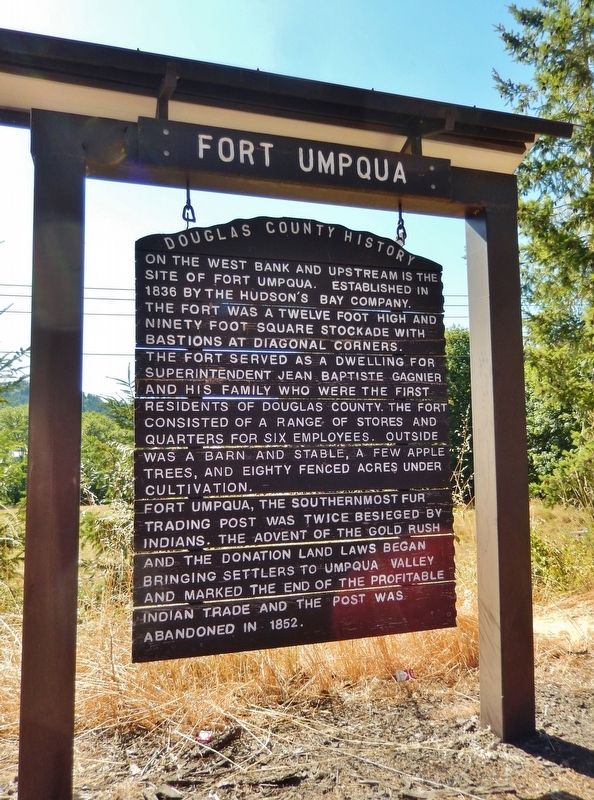
| 101 ► Oregon, Douglas County, Elkton — Fort Umpqua — Douglas County History — |
| On Elkton-Sutherlin Highway (Oregon Route 138) south of Mehl Creek Road, on the right when traveling south. | |||
| 102 ► Oregon, Douglas County, Gardiner — Gardiner — |
| On Oregon Coast Highway (U.S. 101) at Jewett Lane, on the right when traveling south on Oregon Coast Highway. | |||
| 103 ► Oregon, Douglas County, Glendale — City of Glendale — |
| Near 3rd Street at Pacific Avenue. | |||
| 104 ► Oregon, Douglas County, Oakland — Applegate Trail - Oakland — Southern Route to Oregon — |
| On NE 1st Street at SE Maple Street, on the left when traveling north on NE 1st Street. | |||
| 105 ► Oregon, Douglas County, Oakland — Historic Oakland — |
| On 1st Street at Locust Street, on the left when traveling north on 1st Street. | |||
| 106 ► Oregon, Douglas County, Oakland — The First Cabin in Douglas County — |
| On Old Highway 99 North north of North Old Town Road, on the right when traveling north. | |||
| 107 ► Oregon, Douglas County, Roseburg — The Mill-Pine Historic Neighborhood District — |
| On SE Pine Street south of SE Woodward Avenue, on the left when traveling south. | |||
| 108 ► Oregon, Douglas County, Scottsburg — Scottsburg — Oregon History — |
| On Umpqua Highway (Oregon Route 38) at Main Street, on the left when traveling west on Umpqua Highway. | |||
| 109 ► Oregon, Gilliam County, Arlington — Arlington Oregon Trail Kiosk — |
| On Beech Street at Locust Street, on the right when traveling west on Beech Street. | |||
| 110 ► Oregon, Gilliam County, Arlington — This Marks the Crossing of the Old Oregon Trail — Used by Pioneers and Settlers of the Oregon Territory — This Marker in Honor of W.W. Weatherford 1844 - 1926 — |
| On Oregon Route 19, 0.4 miles south of Montague Lane, on the right when traveling south. | |||
| 111 ► Oregon, Grant County, Canyon City — Canyon City Mural — |
| On Park Street at Highway 395, on the right when traveling east on Park Street. | |||
| 112 ► Oregon, Grant County, Canyon City — St Thomas Episcopal Church — National Register of Historic Places — |
| On Washington Street, on the left when traveling south on Washington Street. | |||
| 113 ► Oregon, Grant County, Canyon City — Welcome To Canyon City — Gold Discovered Here In 1862 — |
| On South Washington Street at Park Street, on the left when traveling south on South Washington Street. | |||
| 114 ► Oregon, Grant County, Dayville — An Oregon Fossil Rush — |
| Near John Day Highway (Oregon Route 19) 2 miles north of U.S. 26, on the left when traveling north. | |||
| 115 ► Oregon, Grant County, Dayville — James Cant Ranch Historic District — |
| On State Highway 19 near U.S. 26, on the right when traveling north. | |||
| 116 ► Oregon, Grant County, Dayville — James Cant Ranch Historic District — |
| Near State Highway 19 near U.S. 26, on the right when traveling north. | |||
| 117 ► Oregon, Grant County, Granite — Granite, Oregon / Leaving Granite — |
| On West Center Street at Forest Road 73, on the right when traveling east on West Center Street. | |||
| 118 ► Oregon, Grant County, John Day — John Day/Canyon City — |
| On Northwest Bridge Street just north of West Main Street (U.S. 26), on the right when traveling north. | |||
| 119 ► Oregon, Grant County, John Day — Welcome to Kam Wah Chung — |
| On NW Canton Street when traveling north. | |||
| 120 ► Oregon, Grant County, Prairie City — Sumpter Valley Railroad Hiking Trail — Dixie Pass interpretive site — |
| On John Day Highway (U.S. 26), on the right when traveling east. | |||
| 121 ► Oregon, Harney County, Burns — The Terrible Trail — Oregon History — |
| On U.S. 20 at South Harney Road, on the right when traveling east on U.S. 20. | |||
| 122 ► Oregon, Hood River County, Cascade Locks — Cascade Falls Portage — |
| Near Southwest Cascade Avenue near Wa Na Pa Street. | |||
| 123 ► Oregon, Jackson County, Ashland — A-74 — Applegate Trail - A Pretty Location — |
| On East Main Street, on the right when traveling west. | |||
| 124 ► Oregon, Jackson County, Ashland — A-75 — Applegate Trail - Ashland Creek — |
| On E Hersey Street, on the right when traveling west. | |||
| 125 ► Oregon, Jackson County, Ashland — Ashland Creek — The Ashland Creek watershed has always played and important role in the human history of this region — |
| Near Granite Street. | |||
| 126 ► Oregon, Jackson County, Ashland — Greensprings — |
| On Greensprings Hwy (U.S. 66). | |||
| 127 ► Oregon, Jackson County, Ashland — McCall Magnolia — Magnolia grandiflora — Oregon Heritage Tree — |
| On Oak Street, on the right when traveling south. | |||
| 128 ► Oregon, Jackson County, Ashland — Site of Old Ashland Mill — |
| Near Winburn Way just south of North Main Street, on the left when traveling south. | |||
| 129 ► Oregon, Jackson County, Central Point — A-81 — Applegate Trail - We Took Breakfast — |
| On Old Stage Road at Taylor Road, on the right when traveling north on Old Stage Road. | |||
| 130 ► Oregon, Jackson County, Central Point — Dardanelles — |
| On Old Stage Road near Access Road. | |||
| 131 ► Oregon, Jackson County, Central Point — Hanley Farm Willow — Salix babylonica — Oregon Heritage Tree — |
| Near Hanley Road (Oregon Route 238) 0.5 miles Rossanley Drive (Oregon Route 238), on the right when traveling west. | |||
| 132 ► Oregon, Jackson County, Eagle Point — Eagle Point — |
| On North Royal Avenue near Napa Street. | |||
| 133 ► Oregon, Jackson County, Gold Hill — City of Gold Hill — |
| On 2nd Avenue west of Dardanelles Street, on the right when traveling west. | |||
| 134 ► Oregon, Jackson County, Gold Hill — Rock Point Hotel — Stage Stop and Telegraph Office — |
| On North River Road west of Oregon Route 99, on the right when traveling west. | |||
| 135 ► Oregon, Jackson County, Gold Hill — Rock Point, Oregon — |
| On North River Road west of Oregon Route 99. | |||
| 136 ► Oregon, Jackson County, Gold Hill — The Lure of Gold — |
| On Rogue-Umpqua Scenic Highway (Oregon Route 234). | |||
| 137 ► Oregon, Jackson County, Gold Hill — Valley of the Rogue Applegate Trail Kiosk — |
| Near Interstate 5 at milepost 458, on the right when traveling north. | |||
| 138 ► Oregon, Jackson County, Jacksonville — China Quarter — Jacksonville, Oregon 1865 — |
| On West Main Street. | |||
| 139 ► Oregon, Jackson County, Jacksonville — History Right Here - Going for the Gold — |
| Near West C Street. | |||
| 140 ► Oregon, Jackson County, Jacksonville — Peter Britt: Man of Culture and Commerce — |
| 141 ► Oregon, Jackson County, Medford — A Town is Born — |
| On North Central Avenue at East Main Street, on the left when traveling south on North Central Avenue. | |||
| 142 ► Oregon, Jackson County, Medford — A-78 — Applegate Trail - A Fine Prairie — |
| On Mace Road. | |||
| 143 ► Oregon, Jackson County, Medford — A-77 — Applegate Trail - Down Bear Creek — |
| On South Pacific Hwy (U.S. 99), on the right when traveling north. | |||
| 144 ► Oregon, Jackson County, Medford — A-79 — Applegate Trail - Towards Jacksonville — |
| On South Stage Road, on the left. | |||
| 145 ► Oregon, Jackson County, Medford — Medford Townsite — |
| Near S Ivy St at W 8th St. | |||
| 146 ► Oregon, Jackson County, Pinehurst — Crossing the Siskiyous — |
| Near Green Springs Highway (Oregon Route 66), on the right when traveling west. | |||
| 147 ► Oregon, Jackson County, Pinehurst — Historic Applegate Trail — Tub Springs — |
| On Green Springs Highway (Oregon Route 66), on the right when traveling west. | |||
| 148 ► Oregon, Jackson County, Pinehurst — The Applegate Trail — Tub Springs — |
| Near Green Springs Highway (Oregon Route 66), on the right when traveling west. | |||
| 149 ► Oregon, Jackson County, Rogue River — Crossing the Rogue — |
| On Rogue River Highway (Oregon Route 99) near North Star Lane, on the right when traveling west. | |||
| 150 ► Oregon, Jackson County, Rogue River — Evan's Ferry — |
| On Rogue River Hwy (U.S. 99). | |||
| 151 ► Oregon, Jackson County, Rogue River — Fort Birdseye — |
| On Rogue River Hwy (U.S. 99). | |||
| 152 ► Oregon, Jackson County, Rogue River — The City of Rogue River — |
| On Rogue River Highway (Oregon Route 99) near North Star Lane, on the right when traveling west. | |||
| 153 ► Oregon, Jackson County, Ruch — Ruch — 1976 — |
| On Upper Applegate Rd. | |||
| 154 ► Oregon, Jackson County, Talent — A-76 — Applegate Trail - Bear Creek — |
| On Talent Avenue, on the left when traveling west. | |||
| 155 ► Oregon, Jackson County, Talent — Fort Wagner — 1854 — |
| On Talent Avenue east of Holiday Lane, on the left when traveling west. | |||
| 156 ► Oregon, Josephine County, Cave Junction — Fort Briggs — |
| On Holland Loop Rd, on the right when traveling east. | |||
| 157 ► Oregon, Josephine County, Cave Junction — Oregon Caves National Monument — |
| On Caves Highway (Oregon Route 46). | |||
| 158 ► Oregon, Josephine County, Grants Pass — No Land is Free — |
| Near Interstate 5 at milepost 62 near Merlin Road, on the right when traveling north. | |||
| 159 ► Oregon, Josephine County, Grants Pass — The 1846 Applegate Trail — Southern Route to Oregon — |
| Near Interstate 5 at milepost 62 near Merlin Road, on the right when traveling north. | |||
| 160 ► Oregon, Josephine County, Grants Pass — The First Brick Building in Grants Pass — |
| On Southeast G Street at Southeast 6th Street, on the right when traveling east on Southeast G Street. | |||
| 161 ► Oregon, Josephine County, Kerby — Kerby(ville) 1850's to Present — |
| On Redwood Highway (U.S. 199), on the right when traveling north. | |||
| 162 ► Oregon, Josephine County, Merlin — Rogue River Wars — 1852 to 1856 — |
| On Haines Lane near Pleasant Valley Road, on the right when traveling south. | |||
| 163 ► Oregon, Josephine County, Selma — Fort Hay — |
| On U.S. 199, 0.1 miles south of Draper Valley Road, on the right when traveling north. | |||
| 164 ► Oregon, Josephine County, Sunny Valley — Grave Creek Ranch — 1851 - 1918 — Grave Creek Covered Bridge Historical Site — |
| On Sunny Valley Loop south of Placer Road. | |||
| 165 ► Oregon, Josephine County, Wolf Creek — A-90 — Applegate Trail - Grave Creek — |
| On Sunny Valley Loop, on the left when traveling north. | |||
| 166 ► Oregon, Josephine County, Wolf Creek — Canyon Creek — Oregon History — |
| On I-5 Frontage Road at Ritchie Road, on the right when traveling north on I-5 Frontage Road. | |||
| 167 ► Oregon, Josephine County, Wolf Creek — Feeble, Hungry, and Haggard — |
| On Old State Highway 99 South at Front Street, on the left when traveling north on Old State Highway 99 South. | |||
| 168 ► Oregon, Josephine County, Wolf Creek — GOLD! — |
| On Coyote Creek Road near Bear Gulch Road, on the left when traveling east. | |||
| 169 ► Oregon, Josephine County, Wolf Creek — Golden — |
| On Coyote Creek Road near Bear Gulch Road, on the left when traveling east. | |||
| 170 ► Oregon, Josephine County, Wolf Creek — The Applegate Trail — Southern Route to Oregon — |
| On Sunny Valley Loop north of Interstate 5, on the left when traveling north. | |||
| 171 ► Oregon, Josephine County, Wolf Creek — The Applegate Trail — |
| Near Sunny Valley Loop near Placer Road (Route 34-5-10), on the right when traveling north. | |||
| 172 ► Oregon, Josephine County, Wolf Creek — Wolf Creek Tavern — Wolf Creek Inn — |
| On Front Street at Lower Wolf Creek Road, on the right when traveling south on Front Street. | |||
| 173 ► Oregon, Klamath County, Bonanza — Bonanza — "The Cloverleaf City" — |
| On Main Street at E Langell Valley Rd (Oregon Route 70), on the right when traveling north on Main Street. | |||
| 174 ► Oregon, Klamath County, Bonanza — Gerber Ranch — |
| On Gerber Dam Road. | |||
| 175 ► Oregon, Klamath County, Bonanza — Haynesville — |
| On East Langell Valley Road, on the right when traveling east. | |||
| 176 ► Oregon, Klamath County, Crescent — "Little Meadows" — |
| On Crescent Cutoff Rd (Oregon Route 61) at Riverview Street, on the left when traveling west on Crescent Cutoff Rd. | |||
| 177 ► Oregon, Klamath County, Fort Klamath — Fort Klamath Military Cemetery Memorial — |
| Near Oregon Route 62, 0.1 miles west of County Route 623. | |||
| 178 ► Oregon, Klamath County, Fort Klamath — Ft. Klamath Frontier Post — |
| Near Crater Lake Highway (Route 62). | |||
| 179 ► Oregon, Klamath County, Fort Klamath — Site of Fort Klamath — Established 1863 — Abandoned 1889 — |
| On Crater Lake Highway (Route 62), on the left when traveling north. | |||
| 180 ► Oregon, Klamath County, Fort Klamath — The Town of Fort Klamath — |
| On Oregon Route 62. | |||
| 181 ► Oregon, Klamath County, Keno — Applegate Trail — |
| On Green Springs Highway (Oregon Route 66 at milepost 44) at Toby Grade Road, on the right when traveling west on Green Springs Highway. | |||
| 182 ► Oregon, Klamath County, Keno — Parker Station — |
| Near Green Springs Highway (Oregon Route 66). | |||
| 183 ► Oregon, Klamath County, Keno — Topsy Grade — Stage Coach and Freight Road — |
| On an un-named dirt road south of Green Springs Highway (Oregon Route 66) when traveling south. | |||
| 184 ► Oregon, Klamath County, Klamath Falls — George Nurse — City Father - Arrived 1866 — |
| Near Upham St. | |||
| 185 ► Oregon, Klamath County, Klamath Falls — George Nurse (In Memory of) — June 4, 1820-November 26, 1895 — Founder and Benefactor of Linkville - (Klamath Falls) — |
| On Main Street near Klamath Avenue, on the right when traveling west. | |||
| 186 ► Oregon, Klamath County, Klamath Falls — Klamath County's First White Settler — |
| On Lakeshore Drive, on the right when traveling west. | |||
| 187 ► Oregon, Klamath County, Klamath Falls — Merganser — |
| On Memorial Drive, on the right when traveling west. | |||
| 188 ► Oregon, Klamath County, Klamath Falls — Merganser — |
| On Memorial Drive, on the right when traveling west. | |||
| 189 ► Oregon, Klamath County, Klamath Falls — Pioneer Furtrader — |
| On Main Street, on the right when traveling west. | |||
| 190 ► Oregon, Klamath County, Klamath Falls — Stukel Ranch — 1868 — |
| On Eberlein Ave, on the right when traveling west. | |||
| 191 ► Oregon, Klamath County, Klamath Falls — The River Link — Link River Connecting the Past With the Present — |
| On Link River Trail. | |||
| 192 ► Oregon, Klamath County, Klamath Falls — White Lake City — |
| On Lower Klamath Lake Road, on the right when traveling east. | |||
| 193 ► Oregon, Klamath County, Worden — Applegate Trail — Klamath County — |
| Near U.S. 97, on the right when traveling south. | |||
| 194 ► Oregon, Klamath County, Worden — Western International History — Applegate Trail — |
| On U.S. 97. | |||
| 195 ► Oregon, Lake County, Fort Rock — A Path to the Past — 10,000 Years of Homesteading — |
| On Old Fort Rock Road (County Route 5-10) west of County Route 5-13, on the right when traveling east. | |||
| 196 ► Oregon, Lake County, Fort Rock — Claiming the Desert — |
| On Old Fort Rock Road (County Route 5-10) west of County Route 5-13, on the right when traveling east. | |||
| 197 ► Oregon, Lake County, Fort Rock — Fort Rock — |
| Near County Road 5-11A west of Cabin Lake Road. | |||
| 198 ► Oregon, Lake County, Fort Rock — Fort Rock Grange # 758 — |
| On Fort Rock Road, on the left when traveling east. | |||
| 199 ► Oregon, Lake County, Fort Rock — Home Sweet Home — |
| On Old Fort Rock Road (County Route 5-10) west of County Route 5-13, on the right when traveling east. | |||
| 200 ► Oregon, Lake County, Lakeview — Chandler State Park — |
| Near Fremont Highway (U.S. 395) south of Forest Road 3630, on the left when traveling north. | |||
322 entries matched your criteria. Entries 101 through 200 are listed above. ⊲ Previous 100 — Next 100 ⊳