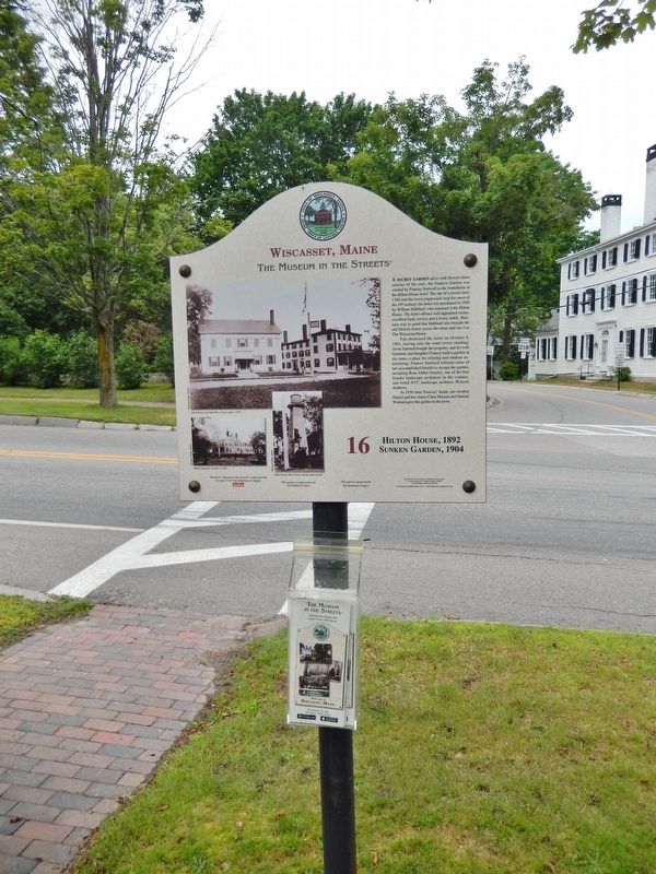
On Main Street (U.S. 1) at Fort Hill Street, on the right when traveling north on Main Street.
A secret garden alive with flowers three seasons of the year, the Sunken Garden was created by Frances Sortwell in the foundation of the Hilton House hotel.
The site of a tavern since 1766 and the town stagecoach stop for most of the 19th . . . — — Map (db m116040) HM
On Main Street (U.S. 1) at Federal Street (Maine Route 218), on the left when traveling north on Main Street.
In 1807, Captain William Nickels
built one of the finest examples of high Federal style architecture in New England, a mansion of beauty, style, and sophistication.
From the elegant entrance to stunning interior detailing, this is a house . . . — — Map (db m116039) HM
On Main Street (U.S. 1) east of Middle Street, on the right when traveling east.
Richard Hawley Tucker Taylor was one of 14 children of James and Harriet Taylor. James was an English mariner who emigrated to the United States. He named his son after his employer, Captain Richard H. Tucker, Sr. When James fell on hard . . . — — Map (db m116045) HM
On Main Street (U.S. 1A/202) near Emerson Street, on the left when traveling north.
This statue, reputed to be the largest of Paul Bunyon in the world, stands facing the Penobscot River. The legendary giant woodsman is a symbol of the great era in the late 1800's when Bangor, Maine was acclaimed to be "The Lumber Capitol of the . . . — — Map (db m4938) HM
On Main Street (U.S. 1A) north of Bass Park Boulevard, on the right when traveling south. Reported permanently removed.
• This permament statue of Paul Bunyon, 31 feet tall and weighing 3700 pounds is made of reinforced fiberglass and internally braced with steel. It stands on a solid concrete foundation the top of which is 6 feet above ground level. Built into the . . . — — Map (db m242468) HM
This scenic overlook named in memory of Maine Highway Pioneer A. J. “Allie” Cole. In 1917 Allie began horse drawn mail, freight and passenger service between Enfield and Burlington, Maine. By the 1920’s he hauled freight in motor trucks . . . — — Map (db m2087) HM
On Millinocket Lake Road, on the right when traveling west.
Welcome to the Golden Road, a 96-mile private road built by the Great Northern Paper Company that stretches from the Canadian border crossing to Millinocket, Maine. The road, which parallels the West Branch of the Penobscot River, was built . . . — — Map (db m136220) HM
On Katahdin Iron Works Road, 6 miles west of Route 11, on the right when traveling west.
Though it has all but vanished, this is the scene that would have appeared directly in front of you had you visited this spot in the 1880’s.
The stone furnace still standing today was once enclosed within a group of buildings that housed each . . . — — Map (db m102285) HM
The white-painted steel structure in front of you is a sculpture representing the bow and stern of the six-mast schooner Wyoming, the largest wooden vessel built in the United States. The sculpture stands where the schooner was built in . . . — — Map (db m52033) HM
The white-painted steel structure in front of you is a sculpture representing the six-mast schooner Wyoming, the largest wooden vessel built in the United States. The sculpture stands where the schooner was built in 1909, but somewhat closer . . . — — Map (db m52038) HM
Known locally as "BIW" or "The Yard," Bath Iron Works has been building ships on the same site since 1890. Over 420 vessels have been built there, including cargo vessels, fishing vessels, yachts, tugs, barges, and naval vessels. Between 1984 and . . . — — Map (db m52032) HM
On Front Street at Centre Street, on the right when traveling north on Front Street.
This marker has two plaques mounted on the same base
Family traditions built this city with blocks of charity.
The old city hall’s shortcomings had been obvious for years, but it took bequest of land and money by George Patten . . . — — Map (db m77084) HM
On Lambard Street near Front Street, on the right when traveling east.
This marker has two plaques mounted on the same base The home of Kings once stood here.
In 1798 William King bought land in the new downtown, just starting on Shaw’s Point, and began to build a home close to the Kennebec River and . . . — — Map (db m77089) HM
In 1920, the Percy & Small shipyard did its last significant ship work. The steamer Winapie, built in New Hampshire during World War One, visited for conversion into a tank barge. The shipyard removed this three-compartment deckhouse, . . . — — Map (db m52056) HM
This major waterway, although in places still undeveloped, remains an important artery for water traffic. The river flows 164 miles from its source at Moosehead Lake to the Atlantic Ocean, 12 miles south of here at Popham. Kennebec is a Wabanaki . . . — — Map (db m52051) HM
Launching featured tradtion, ritual, spectators, and celebration. But it also brought technical challenge and danger to workers and vessel alike.
In preparation, a launching crew built a pair of sliding (or launching) ways beneath the . . . — — Map (db m52059) HM
This sturdy industrial building housed a sawmill for cutting and shaping ship timbers and planks, and a joiner shop for the finer woodworking that went into vessels' cabins, deckhouses, railings, and interiors.
In 1909, the shed addition on . . . — — Map (db m52084) HM
William T. Donnell married Henry P. Hitchcock's daughter Clara in 1860, and bought this house and shipyard from Clara's mother in 1869. The proximity of residence to workplace was unusual. From this house, W. T. Donnell overlooked his shipyard, . . . — — Map (db m52082) HM
The blacksmith shop was the first building constructed by Percy & Small after they purchased the old Blaisdell shipyard site from William Donnell in 1896. It was furnished with forges, bellows, and anvils for fabricating large quantities of . . . — — Map (db m52095) HM
Two building slips, or ways, were important features of the shipyard. The North Ways were prepared as a second building slip, on land purchased in a 1901 expansion. They measured at least 350' long by 50' wide - the largest wooden shipbuilding . . . — — Map (db m52053) HM
A good shipbuilding site has a natural 4° to 12° slope down to deep water.
Using this grade, building slips (ways) were constructed on cleared and graded areas. These were wooden foundations to accommodate the hull under construction and the . . . — — Map (db m52036) HM
This workshop was built in 1899 for Charles Oliver and his caulking gang. Here they stored their tools and some of the miles of oakum and cotton yard needed to make vessels' seams watertight. From the steps, Mr. Oliver could keep an eagle eye on . . . — — Map (db m52031) HM
At the fitting-out pier new vessels received their equipment and finishing work. This pier had a ramp built into its southern side, to land the large timbers and spars that were floated down the river from the railroad yards.
The original 1898 . . . — — Map (db m52048) HM
Design is the first step in shipbuilding, and it took place in a mould loft. Skilled modelers shaped the schooner's hull in miniature by carving a half-model. They scaled the model's lines full-size on the loft floor, then transferred these lines . . . — — Map (db m51988) HM
Caulkers used huge quantities of pitch to pay (or seal) the vessels' deck seams. In the kettles set into this freestanding brick oven, they melted crystallized pine resin over scrap-wood fires, which they carried in buckets to the decks of the . . . — — Map (db m52007) HM
The Percy & Small shipyard was electrified from its establishment in 1896. In 1909, the Sagadahoc Power & Light Company began delivering higher-voltage power to the shipyard on a separate industrial line. The transformer stepped down the voltage . . . — — Map (db m52083) HM
On Church Street east of Main Street, on the right when traveling west.
Welcome to Belfast
In the spring of 1770 Belfast was settled by Scots-Irish families from Londonderry, New Hampshire.
Legend has it that the name Belfast, after the Northern Ireland city, was chosen by a coin-toss.
Fear of . . . — — Map (db m116117) HM
On Footbridge Road, on the left when traveling west.
Despite the decline in ship building, the port of Belfast remained busy at the turn of the 20th century. Rapid industrial development took place all along the west side waterfront, and steamships and railroads became the primary . . . — — Map (db m59508) HM
Belfast in the mid-20th century was firmly established as "Broiler Capital of the World". Hundreds of thousands of chickens were raised in giant barns throughout Waldo County. At the peak of the industry 22,000 birds per hour were . . . — — Map (db m59548) HM
The Downtown Historic District is recognized as a 19th century architectural gem that is included in the National Register of Historic Places. Main Street provided an early route through the dense forests, allowing the farmers and . . . — — Map (db m59495) HM
A brief shipbuilding boom following WWI put the shipyard owned by the Mathews Brothers woodworking mill back in business. The building of the Jennie Flood Kreger, Belfast's largest and only five-masted ship, was overseen by . . . — — Map (db m59549) HM
On Main Street at High Street, on the right when traveling south on Main Street.
The intersection of Main and High Streets formed the commercial crossroads of Belfast and in 1799 it was the site of the first store. Sometimes known as City Block in honor of the impending new city charter, the James Y. McClintock . . . — — Map (db m59388) HM
On Main Street south of Front Street, on the right when traveling south.
Colonel Philo Hersey (panel #9) and two business partners built this imposing shoe factory during the post Civil War period of industrial expansion. At peak production, over 500 workers stood side by side producing several thousand . . . — — Map (db m59382) HM
On this site generations of workers made windows, built ships, and processed poultry. Passengers and freight were carried by sailing ships and steamships to the four corners of the world. In 1999 Belfast Commons was generously given to the citizens . . . — — Map (db m59658) HM
The Post Office and Customs House was built in 1857. Until then offices were housed in various businesses around town. The building still has many original features, including ornate fireplaces and iron fireproof shutters. Post . . . — — Map (db m59494) HM
Steamboats first made scheduled stops in Belfast in 1824, carrying passengers and freight along the coast. The Eastern Steam Ship Company of Boston built the wharf pictured here in 1888. The "Great White Flyer" steamer Belfast . . . — — Map (db m59550) HM
On Market Street at Church Street, on the right when traveling south on Market Street.
When James Langworthy built this Federal style structure in 1835, Market Street, which the building faces, was little more than a cow path leading to a watering hole. But as both a home and store, it was one of more than thirty businesses in . . . — — Map (db m59501) HM
The abundant lumber, steam-powered sawmills and stretches of wide, flat beach, Belfast became a ship building center with shipyards lining the waterfront. In 1793, Robert and James Miller built the schooner Jenny Miller, the . . . — — Map (db m59531) HM
Near Searsport Avenue (U.S. 1), on the right when traveling west.
Originally a cigar making factory, the building shown became Perry's Tropical Nut House when owner Irving Perry started selling pecans in 1926. The business flourished as automobile traffic along Route 1 grew and it soon became . . . — — Map (db m59506) HM
Mathews Brothers Company, started in 1854 by Spencer Mathews and his two brothers, is the oldest manufacturing company in Belfast. After fire destroyed the original factory in 1873 (panel #24), the company reopened just 70 days later . . . — — Map (db m59547) HM
On High Street east of Market Street, on the right when traveling south.
The burgeoning appeal of the silver screen led to the construction of the Colonial Theatre which opened the night the Titanic set sail from England in April 1912. A fire in 1923 following a showing of the film "Way Down East" . . . — — Map (db m59500) HM
On High Street east of Main Street, on the right when traveling west.
By the mid-19th Century Belfast was becoming a popular destination for travelers. The
Windsor Hotel, originally built as a private home in 1807, was enlarged to accommodate the influx of guests and lodgers. First known as the New . . . — — Map (db m59385) HM
On East Main Street (Rt. US-1) at Mosman Street, on the right when traveling east on East Main Street (Rt. US-1).
Early financial business in Searsport was transacted in Counting Houses. The growth of commerce and industry in the mid 19th Century created the need for a bank. On August 1, 1853, Jeremiah Merithew organized the Searsport Bank which . . . — — Map (db m46652) HM
On East Main Street (U.S. 1) at Knox Bros. Avenue, on the left when traveling east on East Main Street.
In the 19th Century, Searsport was a busy prosperous town. Although best known for shipbuilding and its supporting industries, there was a barrel factory, a spool factory and grain and lumber mills. In one block on Main Street there . . . — — Map (db m46648) HM
On East Main Street (Rt. US-1) at Leach Street, on the right when traveling east on East Main Street (Rt. US-1).
For the better part of the 19th Century Searsport shores were busy with shipbuilding and supporting industries. Close to the yards were steam sheds for bending timbers and planking, blacksmith shops, oakum shops, an iron foundry and . . . — — Map (db m46651) HM
On East Main Street (Rt. US-1) at Pike Street, on the right when traveling east on East Main Street (Rt. US-1).
Searsport House was one of the best hotels to be found outside the larger cities, according to The Industrial Journal, Dec. 1909. Built in 1831, the original building was occupied as a private dwelling until 1835 when it was . . . — — Map (db m46654) HM
On East Main Street (Rt. US-1) at Mortland Road, on the left when traveling east on East Main Street (Rt. US-1).
Until 1800, Settlers in the area were occupied in establishing themselves on the land. At the same time trade up and down the coast and with Massachusetts was by water in sloops and small schooners. These coastal farmers were as much . . . — — Map (db m46659) HM
On West Main Street (Rt. US-1) west of Steamboat Avenue, on the right when traveling east.
On the site across the stream, there was first a grain and then a lumber mill. The dammed up stream provided power to turn the wheel to grind the grain or saw the logs. The stream also provided a conduit for logs floated down to the . . . — — Map (db m46657) HM
On Maine Route 190, 0.1 miles east of Kendall’s Head Road, on the right when traveling east.
Cobscook Bay is one of Maine’s special places. Its huge tides (averaging 28 feet but sometimes surging to 30 feet) its cold nutrient rich waters, convoluted and largely undeveloped shoreline, vast intertidal areas provide habitat for a wide array . . . — — Map (db m183678) HM
On Water Street at Furniture Avenue, on the right when traveling south on Water Street.
By: Samuel Bartlett Wadsworth (9/1/1791- 10/2/1874)
Son of: General Peleg Wadsworth
Uncle to: Henry Wadsworth Longfellow
★ Formerly Located: Central Wharf 1818- 1976 ★
(left plaque)
This property has been placed on . . . — — Map (db m207785) HM
On Water Street at Furniture Avenue, on the right when traveling north on Water Street.
Eastport's fishing industry has sustained the area from the city's beginning. Originally, shallow-water fish harvesting was adapted from Passamaquoddy Indians' use of weirs. Eventually, Eastport became the Sardine Capital of the World, at onetime . . . — — Map (db m183641) HM
On Harrington Road (U.S. 1) at Station Road, on the right when traveling north on Harrington Road.
An 1836 evaluation of Maine's mineral resources found granite to be one of the state's most important commodities. Jonesboro was one of the hubs of granite production in eastern Maine. Fletcher Granite Company described granite from the Bodwell . . . — — Map (db m183769) HM
On Harrington Road (U.S. 1) south of Whitney Road, on the left when traveling north.
Schoppee's Garage Founded circa 1928 by Harrison (Hassey) Schoppee, Schoppee's Garage was originally on the south side of the Chandler River. When he learned that construction of a new bridge would realign Rt. 1 through his business, Hassey . . . — — Map (db m183739) HM
On Harrington Toad (U.S. 1) at Station Road, on the right when traveling north on Harrington Toad.
Early Jonesboro, known as Chandler's River, was one of the best timbered in the area of what is now the state of Maine. A heavy growth of old pine lined its banks for miles up and down the river. In 1764 an early pioneer, Judah Chandler, built the . . . — — Map (db m183790) HM
On Harrington Road (U.S. 1) at Station Road, on the right when traveling north on Harrington Road.
Shipbuilding was an important enterprise in the early history of Jonesboro. The types of vessels built from 1816 through 1887 were varied and included schooners, sloops, brigs and barks. Accounts as to the number of ships built in the town of . . . — — Map (db m183782) HM
Native Americans called the falls next to this sign Machias, the popular translation of which is "bad little falls." The name Machias now applies to the nearby towns and rivers. South of Bad Little Falls, river water mixes with sea water brought in . . . — — Map (db m54743) HM
On U.S. 1, 0.3 miles north of Cropley Road, on the right when traveling south.
Rural Weston, once home to classic farms: Big house, little house, outhouse, barn.
In this sparsely-populated town of several hundred, look for a few remaining farms perched amidst fields slowly returning to forest. Local settlers like . . . — — Map (db m125267) HM
On U.S. 1 north of Moody Lane, on the right when traveling north.
In the 1880's, leather production was one of Maine's largest industries
An industry built on Hemlock, plentiful pure water and rail. Hemlock tan-bark makes a "tea" high in tannin used to cure raw animal hides. Entrepreneurs located . . . — — Map (db m125308) HM
On Alfred Street (Maine Route 9) at Main Street (Maine Route 9), on the left when traveling south on Alfred Street.
The construction of Alfred Street was ordered by the County Court in 1828. It was intended to pass through the center of valuable mill sites and connect directly to Main Street, Saco. Protests and petitions over this originated in . . . — — Map (db m186157) HM
On Water Street at Sullivan Street, on the right when traveling east on Water Street.
Welcome to Biddeford
An early Industrial Revolution site, Biddeford was settledin 1630 by proprietors John Oldham and Richard Vines. They received their land grant as payment for services to the Plymouth Company in 1629. John . . . — — Map (db m186151) HM
On Main Street at Adams Street, on the left when traveling west on Main Street.
Welcome to Biddeford
An early Industrial Revolution site, Biddeford was settledin 1630 by proprietors John Oldham and Richard Vines. They received their land grant as payment for services to the Plymouth Company in 1629. John . . . — — Map (db m186168) HM
On Alfred Street (Maine Route 9) just south of Main Street (Maine Route 9), on the right when traveling north.
Alfred Bonneau started publishing La Justice, a weekly French-language newspaper, in 1893. It was published until 1950. Joseph C. Bolduc was the last editor. Alfred Bonneau was a prominent citizen and one of the foremost . . . — — Map (db m186160) HM
On Adams Street south of Main Street, on the right when traveling south.
The Biddeford Daily Journal as a weekly abolitionist paper. Saco publishers Cowen and Noyes purchased the Eastern Journal which became the Union Journal in 1858, then the Biddeford Daily Journal in 1858, . . . — — Map (db m186172) HM
On St. Mary's Street at Hazel Street on St. Mary's Street.
In 1848, Irish Catholics celebrated their first mass in the Emery House at the foot of Emery Street in Biddeford with Father McGuire of the parish of St. Dominic's in Portland. Around 1850, Catholics started to congregate . . . — — Map (db m186182) HM
On Water Street at Sullivan Street, on the right when traveling west on Water Street.
The Water Street area once had several shipyards. The painting is of the Mt. Washington clipper ship done while in Canton Harbor, China. Built in 1867 at the height of the China trade, the ship was the largest built on the Saco . . . — — Map (db m186152) HM
On Main Street at Laconia Street, on the right when traveling west on Main Street.
The first mill in Biddeford was the Laconia Compny founded by Samuel Batchelder in 1841. Production of cloth began in 1845. Some twelve million bricks were used in the construction. A large machine shop and foundry were constructed . . . — — Map (db m186156) HM
On Main Street at Lincoln Street, on the right when traveling west on Main Street.
The Lincoln Street Mill went into production in 1853. With additions it contained eight million square feet of floor space. Power from the Saco river arrived in 27-foot diameter brick-lined tunnels. Turbines converted the flow into . . . — — Map (db m186164) HM
On Main Street at Adams Street, on the left when traveling west on Main Street.
Hotel Thacher was built in 1847 by the Saco Water Power Co. and was originally known as the Biddeford House. It was renamed Hotel Thacher in 1894 in honor of Judge George Thacher. The lines of the block, its roof, and its windows . . . — — Map (db m186166) HM
On Stone Street west of Lincoln Street, on the right when traveling north.
Reverend Tracy of the second Congregational Church and later Pastor of the Second Parish Congregational Church of Saco built this large late Federal style house in 1826. Reverend Tracy came to Biddeford from Cambridge, Massachusetts . . . — — Map (db m186180) HM
On Main Street (U.S. 1) just south of Fletcher Street (Maine Route 35), on the right when traveling south.
This Federal home was built in 1799 for Nathaniel Frost by Thomas Eaton who was responsible for many residential and commercial buildings in Kennebunk. The original building on this lot was built by Theodore Lyman in 1770 and later . . . — — Map (db m186320) HM
On Depot Street at Summer Street (Maine Route 9A/35), on the right when traveling north on Depot Street.
This depot was constructed in 1872 when the Boston & Maine Railroad operated a branch line between Portland and South Berwick, Maine. It is an example of Stick-style architecture. During the late 1800, tourists to the area were met . . . — — Map (db m186335) HM
On Main Street (U.S. 1) just south of Elm Street (Maine Route 9A/35), on the right when traveling south.
This quartet of buildings, which now forms the Brick Store Museum, was operated as separate businesses throughout the decades. The brick building was erected in 1825 by wealthy merchant and ship owner, William Lord. In 1936 Lord's . . . — — Map (db m186324) HM
On Summer Street (Maine Route 9A/35) just west of Durrell's Bridge Road, on the left when traveling west.
The Hugh McCulloch home was actually built in 1787 for Tomas Wiswell. The home ha a massive center chimney and three upstairs bedrooms have hinged walls which can be swung upward and secured to the ceiling to create a large ballroom. . . . — — Map (db m186345) HM
On Main Street (Route 1) at Water Street, on the left when traveling west on Main Street.
Welcome to Kennebunk
The Native American word “Kennebunk” means “long cut bank” and likely refers to Great Hill at the mouth of the Mousam River which would have been an important landmark to those traveling the coast in their . . . — — Map (db m186306) HM
On Summer Street (Maine Route 9A/35) at Elm Street, on the right when traveling east on Summer Street.
Welcome to Kennebunk
The Native American word “Kennebunk” means “long cut bank” and likely refers to Great Hill at the mouth of the Mousam River which would have been an important landmark to those traveling the coast in their . . . — — Map (db m186327) HM
Near Friendly Pines Lane south of Constitution Road, on the right when traveling east.
More than 20 vessls were built on the Mousm River between the years of 1760 and 1790. Most vessels were built here at what was then "The John Butland Shipyard." The largest vessel weighed nearly 240 tons. Many of the earliest . . . — — Map (db m186348) HM
On Dane Street at Elm Street, on the right when traveling north on Dane Street.
The Dr. Lemuel Richards home was originally built in 1800 for William Taylor who lived here until 1815. After suffering financial losses, due to the War of 1812, Taylor sold the home to William Hackett and Timothy Frost who were . . . — — Map (db m186326) HM
On Summer Street (Maine Route 9A/35) at Sea Road, on the right when traveling east on Summer Street.
This Second Empire style home with mansard roof was built for merchant George Wise in 1868 just three years after the Civil War ended. This home occupies the site which was previously owned by George's father, Captain Daniel Wise, . . . — — Map (db m186338) HM
On Main Street (U.S. 1) just north of Bourne Street, on the left when traveling north.
This Greek Revival home was built by Beniah Littlefield for Horace Porter in 1848. The land was originally owned by Horace’s father, Joseph Porter, who operated a tin shop on the premises. Horace was a wealthy merchant who had this . . . — — Map (db m186319) HM
On Main Street (U.S. 1) at Water Street, on the left when traveling west on Main Street.
Numerous manufacturers have occupied this site throughout Kennebunk’s history. Since the first settlement of Kennebunk in the mid 1600s, until now, the Mousam River has been the site of many industries including sawmills, textile and . . . — — Map (db m186307) HM
On Summer Street (Maine Route 9A/35) at Moulton Farm Road, on the right when traveling east on Summer Street.
The depression in the bank across the street is one of the last visible remains of a once thriving shipbuilding industry which existed along the western banks of the Kennebunk River. Prior to 1790, most shipbuilding was done on the . . . — — Map (db m186344) HM
On Main Street (U.S. 1) at Wells Court, on the right when traveling south on Main Street.
This brick building was built by Dr. Frank Ross in 1885 following destructive fires which destroyed the two previous wooden buildings that stood here. This brick building, originally only two stories tall, initially housed Dr. Ross’s . . . — — Map (db m186310) HM
On Storer Street just north of Berry Court, on the right when traveling north.
This home was constructed in 1758 by Joseph Storer and his wife Hannah. Storer was the wealthiest man in Kennebunk at the time and owned a saw mill, country store and grist mill. He entered into the Revolutionary War in 1777. He was . . . — — Map (db m186308) HM
On Summer Street (Route 9A/35) just east of Gilpatrick Shiphard Lane, on the right when traveling east.
Originally this Federal style, brick home was undadorned when built by George Washington Bourne in 1826. The main structure is brick. Following a fire in 1852 which destroyed the original barn, Bourne decided to rebuild it. He added . . . — — Map (db m186343) HM
On York Street (U.S. 1) just north of Swan Street, on the left when traveling north.
This Federal home was designed by Thomas Eaton in 1804 for George W. Wallingford. George Wallingford was born in 1775 and was a graduate of Harvard College in 1795. He was admitted to the bar in 1798 and began practicing law in . . . — — Map (db m186301) HM
On Summer Street (Maine Route 9A/35) at Park Street, on the right when traveling east on Summer Street.
The upper section of Summer Street was settled by wealthy ship builders and business men, many belonging to the Lord and Thompson families. It became known as "Zion's Hill" in 1833 when the sale of liquor was debated by the . . . — — Map (db m186334) HM
Near Mac Donough Avenue near Charles/Morris Avenue.
The Shipyard Mall has been a gathering area since the Civil War when Shipyarders took their oath of allegiance here. The shipyard flagpole stands majestically in its center and numerous monuments are located throughout the park. The sail of the USS . . . — — Map (db m31696) HM
On Colby Avenue east of Clover Street, on the left when traveling west.
Opened as the Granite State House by Mrs. I.C. Estes, the hotel was purchased in 1911 by Frank Hale Thurston. Renamed, it was enlarged to include forty-four guest rooms, a bakery, a soda fountain, a barbershop, telegraph and post offices, and two . . . — — Map (db m156357) HM
On Portland Avenue at Imperial Street, on the right when traveling south on Portland Avenue.
The original Staples Inn was erected circa 1730. It was acquired by Elisha Staples in the 1790's. His grandson, Ebenezer C. Staples, opened the farmhouse to visitors circa 1840, and is believed to be the first person in town to take in boarders. . . . — — Map (db m205656) HM
On Beach Street (Maine Route 9) at Main Street, on the right when traveling east on Beach Street.
Saco native Samuel Brannan became one of the country’s richest men promoting the California gold rush, and one of the most colorful figures in California history, but he wasn’t a gold miner and he died in poverty.
Brannan was born in Saco in . . . — — Map (db m55699) HM
On Main Street (Maine Route 4A) at School Street, on the right on Main Street.
Front and Rear Erected by the citizens of Sanford to the memory of Thomas Goodall founder of the Sanford Mills and the Goodall Worsted Company Born in Dewsbury Yorkshire England 1823 Died in Sanford Maine 1910
Side A
The Sanford . . . — — Map (db m96209) HM
Near Skinner Mill Road north of Laudholm Farm Road, on the right when traveling north.
Robert W. Lord imported Guernsey cows from England in 1892. Guernseys were rare in Maine, but produced rich milk and displayed gentle dispositions.
In the early 20th century, this area was a fenced yard for cows. Prospective buyers inspected . . . — — Map (db m186473) HM
Near Skinner Mill Road north of Laudholm Farm Road, on the right when traveling north.
The creamery was used for bottling and canning milk, making cheese, and churning cream into butter. The original creamery was attached to the Maine Coastal Ecology Center in 2001.
Neighbors who stopped by to pick up their milk would mark off . . . — — Map (db m186468) HM
Near Skinner Mill Road north of Laudholm Farm Road, on the right when traveling north.
Farmhands cut blocks of ice from a nearby mill pond, packed them in sawdust, and stored them in this building. Ice was vital for keeping the evening's milk and cream fresh for summer morning deliveries.
Even after automobiles became . . . — — Map (db m186470) HM
On York Street (U.S. 1A) at Long Sands Road, on the left when traveling north on York Street.
During the first half of the twentieth century the triangle created by the intersection of York Street and Long Sands Road was a busy village center where people came for their groceries, sundries, and hardware.
There were taverns, a barber . . . — — Map (db m116000) HM
200 entries matched your criteria. Entries 101 through 200 are listed above. ⊲ Previous 100