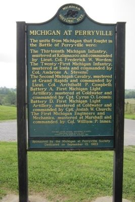
Among the 61,000 Union soldiers who at the Battle of Perryville ended Confederate attempts to gain control of Kentucky were six Michigan units. The most heavily engaged of these were Coldwater’s Loomis Battery (Battery A of the . . . — — Map (db m46357) HM
(Obverse Side)
Michigan Light Artillery Regiment
During the Civil War more than three thousand men served in Michigan's First Regiment of Artillery. The twelve batteries saw action in both major theaters. Unlike in infantry . . . — — Map (db m66937) HM
Side 1
During the first week of July 1863, while the people of the North and the South focused their attention on Gettysburg and Vicksburg, five Michigan companies defended the bridge across the Green River here at Tebbs Bend. They were . . . — — Map (db m99030) HM
More than 90,000 Michigan men served in the Union Army and Navy during the Civil War. The 17th Michigan Volunteer Infantry Regiment was mustered at the Detroit Barracks in August 1862 under the command of Colonel William H. Withington. The . . . — — Map (db m158389) HM
Built in 1870, across from the township hall, Greenbush School is one of Alcona County’s pioneer schools. It remained a part of the Alcona County educational system until 1947. The school began with twenty-five students, kindergarten through . . . — — Map (db m121967) HM
Le lac supérieur the French called it, meaning only that geographically it lay above Lake Huron. In size, however, Lake Superior stands above all other freshwater lakes in the world. The intrepid Frenchman Brulé discovered it around 1622. . . . — — Map (db m41968) HM
Swedish pioneer Charles Paulson purchased one hundred acres of land here in 1884 and constructed this cabin for his family home. Built of hand hewn cedar logs securely dovetailed at the corners, the house was occupied by Paulson and his wife until . . . — — Map (db m206179) HM
Allegan County's name was coined by the noted student of the Indians, Henry Schoolcraft. The county was set off in 1831 and organized in 1835. Settlement of the county seat, Allegan, was promoted in 1835 by eastern capitalists who were attracted by . . . — — Map (db m69891) HM
On June 15, 1858, the Episcopal Church of the Good Shepherd was organized; its parish was admitted into the Diocese of Michigan two years later. Built in 1866-69, this Gothic structure was designed by Gordon W. Lloyd and first used for Divine . . . — — Map (db m69890) HM
This simply ornamented wrought-iron bridge was built in 1886. It replaced an earlier wooden one that had begun to fall into disrepair. Designed by the King Iron Bridge and Manufacturing Company of Cleveland, Ohio, the double-intersection Pratt . . . — — Map (db m69901) HM
Side 1
In 1866, faced with the growth of what were then the separate villages of Douglas and Dudleyville, Saugatauk Township Districts No. 3 and 4 merged forming Union District No. 3. The Douglas Union School opened for classes in . . . — — Map (db m45325) HM
Dutcher Lodge No. 193
Masons from Douglas, Fennville, and Saugatauk chartered Dutcher Lodge No. 193 on January 19, 1867. From 1867 to 1870 they held meetings in a building owned by Worshipful Master Thomas Dutcher. In 1875, the western . . . — — Map (db m45393) HM
From about 1854 to at least 1863, this surfboat was used for lifesaving purposes near the Saugatuck Lighthouse. It was one of 48 used on the Great Lakes and one of 137 used nationally. Joseph Francis, owner of the Francis Metallic Lifeboat Company, . . . — — Map (db m182126) HM
Surveyed in 1839, the village of Pier Cove was once hailed as "the busiest port between St. Joseph and Muskegon." Before the Civil War, Pier Cove was a bustling community and a major point for lumber distribution, with ships departing daily carrying . . . — — Map (db m73498) HM
Spanning the Kalamazoo River, this 422-foot bridge is one of Michigan’s longest pony truss highway bridges, and among the oldest surviving swing bridges in the United States. The Milwaukee Bridge and Iron Company fabricated the $5,000 structure, . . . — — Map (db m73574) HM
A Dutch settlement known as Oakland sprang up in this area about a decade after the founding of nearby Holland in 1847. Many residents worshipped with the Vriesland and Drenthe congregations until they formed their own churches. One group, North . . . — — Map (db m73681) HM
Members of the First Reformed Church in Holland founded this congregation in 1866 to provide a place of worship for the settlers living southeast of town. Heavy immigration from the Netherlands prompted this move. The Dutch language was used . . . — — Map (db m73682) HM
(Side One)
Erected in 1862, this church was the center of the Dutch immigrant community. The first settlers in this area arrived in early 1847 led by the Reverend Albertus C. V. Raalte. In June of that year a separate group of seventy . . . — — Map (db m73685) HM
The main portion of this building was the residence of George N. Smith, a Congregational missionary to the Indians in this area and at Waukazoo's Village on nearby Lake Macatawa. The mission was named after an Indian convert. Built in 1844-45 by . . . — — Map (db m73683) HM
Laketown Township was settled by Dutch immigrants who arrived in the area in 1847. Originally part of Newark Township, Laketown was set off in 1858 and named for its proximity to Lake Michigan. Officials did not have a meeting hall until 1884 when . . . — — Map (db m73641) HM
The Otsego Methodist Church was organized in 1842 and served by a traveling minister. The first church was built on this site in 1847. On December 22, 1889, over 900 townspeople attended the dedication of the present church. Many donated money . . . — — Map (db m69960) HM
(Side One)
Overisel
Seeking religious liberty and better economic opportunity in a new land, the Reverend Seine Bolks and a congregation of about two dozen families, left Hellendoorn, Province of Overisel, The Netherlands, on . . . — — Map (db m73646) HM
All Saints Episcopal Church An Episcopal parish was organized in Saugatauk on All Saints Day, November 1, 1868. Services were held at various locations until 1873. In 1871 the parish purchased property. Detroit architect Gordon W. Lloyd . . . — — Map (db m45324) HM
Chicago inventor and businessman Dorr Felt built this house as a summer home for his wife, Agnes. Felt held numerous patents, mostly notably for the Comptometer, the first machine to do complex calculations. In 1919 Felt purchased more than 750 . . . — — Map (db m73640) HM
On January 11, 1860, eight years before Saugatuck was incorporated as a village, a council of area Congregational leaders met in the Pine Grove schoolhouse and organized a church. During the summer the congregation built a church on this site, which . . . — — Map (db m45457) HM
Roger E. Reed, whose father was a blacksmith and carriage maker, built this structure in 1905. The front of the building housed an office and carriages, while the back was a stable of 25 stalls. Here travelers boarded stages bound for Holland, Grand . . . — — Map (db m45238) HM
The village of Saugatuck built this structure in 1904
to house the community’s first water pumps. The
building’s construction cost about $720.
The pumps were part of a water system designed by
John W. Alvord, an engineer from Chicago. The
two . . . — — Map (db m154313) HM
Beneath the sands near the mouth of the Kalamazoo River lies the site of Singapore, one of Michigan's most famous ghost towns. Founded in the 1830's by New York land speculators, who hoped it would rival Chicago or Milwaukee as a lake port, . . . — — Map (db m45269) HM
When Allegan county was organized in 1835, the only road from the interior to Lake Michigan followed an Indian Trail along the Kalamazoo River. In 1838 Ralph Mann of Connecticut was supervising improvements at the short-lived town of Richmond. He . . . — — Map (db m73603) HM
Upon her death in April 1899, Julia Robinson Henika bequeathed two thousand dollars to the Wayland Ladies Library Association for construction of a library building. Her husband George H. Henika, and mother, Mary Forbes, later donated additional . . . — — Map (db m73679) HM
Located on the Government Square, City Hall remains one of Alpena’s most prominent structures. In 1904 when the city council chose to construct the building of Bedford (Indiana) limestone rather than local limestone or concrete from Alpena’s . . . — — Map (db m121900) HM
"Alpena has blazed a new trail in construction," architect William H. Kuni of Detroit declared at the opening of the Alpena County Courthouse on October 21, 1935. Calling it "the first monolithic building erected in a cold climate," Kuni designed . . . — — Map (db m66795) HM
In 1861 Bishop Frederic Baraga (1797-1868) trod through snow and icy waters from Sault Ste. Marie to Alpena where he founded a Catholic church. However, it was not until 1866 that Father Patrick Murray became the first resident pastor of the church . . . — — Map (db m121899) HM
In 1891-92 the Chicago and West Michigan Railway, precursor to the
Pere Marquette Railroad, extended the line between Traverse City and
Petoskey through Spencer Creek. William Alden Smith, the railway's
general counsel, advocated building the . . . — — Map (db m190676) HM
In the late 1850s traveling pastors
began to conduct Methodist services in
Elk Rapids and nearby communities.
First Methodist Episcopal Church was
organized in the early 1870s. Services
were held in a former school and then a
former . . . — — Map (db m234753) HM
Edwin S. Noble (1838-1922) designed
and built this house for his family in
1865. Noble, an expert accountant,
was associated with the Dexter Noble
Company, first as secretary-treasurer
and later as a full partner. The company
was involved in . . . — — Map (db m234603) HM
Designed by Charles H.Peale
and built in 1883 near the
site where the earliest
white settler, Abram Wadsworth had lived, the Elk
Rapids Township Hall has
served as a social and
political center
center for over
ninety years. Largely due
to . . . — — Map (db m234752) HM
On November 10, 1881, the Antrim County Herald ran an advertisement about the village of Wetzell that read: "New Town, New Store; Everything New!" Earlier that year the Wetzell brothers had platted the village and opened a sawmill. As the . . . — — Map (db m215768) HM
This churchlike white frame structure with its graceful cupola was built in 1890 as the second Arenac County Courthouse. The first courthouse on this site burned the previous year. Omer had been a part of Bay
County until Arenac was organized in . . . — — Map (db m70969) HM
This region's history is long and rich. Father Ménard, the Jesuit missionary, wintered near what is now L'Anse in 1660-1661. Near here Father Baraga set up his mission in 1843. He and the head of the neighboring Methodist mission, the Rev. J. . . . — — Map (db m76282) HM
Central School Hastings built the first school on this site in 1852. It burned in 1871, and the second school was constructed. Hailed as a "landmark of progress," the new building served until 1930 when it was razed. Bucks from that structure . . . — — Map (db m216612) HM
Barry County, organized in 1839, was named after U.S. Postmaster General William Barry. Hastings, the county seat, was platted in 1836 and chartered as a village in 1855. The present courthouse was completed in 1892. A newspaper was published here . . . — — Map (db m150276) HM
Oakland County physician
George W. Lowry (1850-1922)
purchased this lot and a
medical practice from Dr.
William A. Upjohn in 1887.
In 1892-1894 he built one of
Hasting's finest residences,
which also housed his medical office. The . . . — — Map (db m216360) HM
Kim Sigler (1894-1953), a native of Schuyler, Nebraska, received his law degree from the University of Detroit in 1918. While attending law school, Sigler worked at Henry Ford’s Highland Park plant. He first practiced law in Detroit, where he . . . — — Map (db m150275) HM
On April 5, 1885, the Michigan Mutual Tornado, Cyclone, and Windstorm Insurance Company became the first mutual windstorm company incorporated by the state of Michigan. Starting in a one-room office above Grant's store, the company occupied and . . . — — Map (db m33250) HM
From 1872 to 1963 Hope Township children attended school in this building, known as the Hinds School because of its location at the crossroads community of Hinds Corners. The school had stood vacant for almost twenty years when Robert Casey, a Hinds . . . — — Map (db m191509) HM
In the early nineteenth century the Thornapple band of Ottawa Indians established a village a short distance from Thornapple Lake. It was served in the 1840s by a Methodist mission and school conducted by the Reverend Mannaseh Hickey. Trails leading . . . — — Map (db m191511) HM
This steel Pratt through truss bridge was erected for Hastings Township in 1903. The township contracted with the Massillon Bridge Company of Massillon, Ohio, for $2,090, to fabricate and erect the steel bridge. In operation from 1869 to the 1930s, . . . — — Map (db m191510) HM
The first Methodist Episcopal Society, the oldest congregation in Hastings, erected this Greek Revival structure in 1860. In 1911 the Methodists built a new church on the northwest corner of Green and Church Streets. The following year it sold the . . . — — Map (db m199125) HM
Hastings was first linked
with Jackson and Grand
Rapids by the Grand River
Valley Railroad in 1870.
The Michigan Central Railroad leased the line that
same year. At first located
elsewhere, a passenger
station was built on this
site in . . . — — Map (db m216359) HM
Built in the 1880s by Daniel Striker, this Queen Anne-style building was once considered the "handsomest residence in Hastings." Born in New York State in 1835, Striker moved as a child with his family to Michigan. He was elected to several . . . — — Map (db m216572) HM
In 1850 George Thomas operated a sawmill here, and in the next decade as settlers began to arrive he built a gristmill. The new village, also known as Gull Lake, was a few miles south of the Reverend Leonard Slater’s Baptist Indian mission. Thomas . . . — — Map (db m191508) HM
In 1878 twelve persons organized the Parmelee Methodist Church. The small congregation met at various locations until 1884, when this church was built on land given to the Methodist Trustee Board by Oliver and Bernice Carpenter. On September 15, . . . — — Map (db m215391) HM
Settlement began here in the mid-1830s, and in 1850 a post office known as Gun Lake was established. The village, never over 100 population, contained a sawmill, general store, blacksmith shop, and several other businesses. E. H. Bowen constructed . . . — — Map (db m216624) HM
Emory Parady was born in New York in 1844. On April 24, 1865, he was one of twenty-seven men from the 16th New York Cavalry Regiment who rode with the two detectives tracking John Wilkes Booth after the assassination of President Abraham Lincoln. On . . . — — Map (db m191499) HM
Built in 1884/85, this red-bricked Italianate structure was the home of Charles W. and Agnes Putnam. Mr. Putnam was a hardware merchant and banker; Mrs. Putnam taught music and was the first public school teacher in Nashville. Around the turn of the . . . — — Map (db m191514) HM
This village was settled in the mid-nineteenth century, and in 1857 a post office was opened. By 1860 a town of several blocks was established, and the businesses included a gristmill, hotel, and sash factory. The gristmill, run by Melatiah J. . . . — — Map (db m216525) HM
Near here once stood one of the most famous inns west of Detroit. It was run by “Yankee Bill” Lewis, a New Yorker who came here in 1836. His establishment, located on the main road from Grand Rapids to Battle Creek and Kalamazoo, was an unimposing . . . — — Map (db m216617) HM
In 1868 the Williams Township Board of Health authorized a township burial ground and voted to purchase land for that purpose. In 1871 the board purchased five acres previously designated for school purposes from the state of Michigan for twenty . . . — — Map (db m163589) HM
When Bay City's sawmills opened in 1885, mill owners notified workers that wages would be 12 to 25 percent lower than in 1884. On July 6, 1885, Bay City millhands began to walk off the job. Their slogan, "Ten Hours or No Sawdust," represented . . . — — Map (db m162453) HM
Center Avenue presents one of the most spectacular displays of late nineteenth and early twentieth century residential architecture in Michigan. Between 1870 and 1940 Bay City's prominent citizens favored Center Avenue as "the" place to live. Early . . . — — Map (db m33961) HM
Center Avenue presents one of the most spectacular displays of late nineteenth and early twentieth century residential architecture in Michigan. Between 1870 and 1940 Bay City´s prominent citizens favored Center Avenue as "the" place to live. Early . . . — — Map (db m161001) HM
Side 1
In 1848, James G. Birney and his wife led Bay City's earliest Presbyterian services in a schoolhouse. Birney, an elder in the church, twice ran unsuccessfully for president on the antislavery ticket. The Reverend Lucius Root organized . . . — — Map (db m33696) HM
Frankenlust
One of four colonies in Michigan settled by people from Franconia, Germany, Frankenlust was founded by Pastor Ferdinand Sievers and fourteen immigrants who established Saint Paul Evangelical Lutheran Church in June 1848. On July . . . — — Map (db m138097) HM
The Midland Street Commercial District comprises fifty buildings in a four-block area that was the business hub of West Bay City. Prior to 1830 the area was occupied by Sauk and Chippewa Indians. In response to depleted eastern timberlands resulting . . . — — Map (db m163221) HM
Established in 1847, the Ogaukawning Indian Mission, the first church in present-day Bay County, served Chippewa Indians at the nearby Kawkawlin settlement. First ministered by Methodist missionaries, it soon came under Indian trusteeship and still . . . — — Map (db m182297) HM
Henry W. Sage (1814-1897) founded the village of Wenona (later West Bay City) in 1863. A merchant and philanthropist, he was also a founder of the Sage, McGraw and Company sawmill. In 1881 he donated property, building funds and $10,000 for books to . . . — — Map (db m163167) HM
This bay derives its name from the Sauk Indians who once dwelt by its shores. Adrien Jolliet, on his voyage down Lake Huron’s western shore in 1669, first made it known to the white man. In the late 1800's an immense lumber industry flourished in . . . — — Map (db m182360) HM
St. Joseph was the first Catholic parish in the Saginaw Valley when it was founded in 1850-51 by missionary Joseph Kindekens. Dedicated on March 19, 1911, this building is the third to serve St. Joseph. During the late nineteenth century St. Joseph . . . — — Map (db m162342) HM
St. Stanislaus Kostka Roman Catholic Church
In the second half of the nineteenth century, Polish refugees who escaped Prussian domination settled in Bay City. In 1874 they formed a society under the patronage of Saint Stanislaus Kostka of . . . — — Map (db m161004) HM
During the 1870s, Swedish immigrants arrived in Bay County. By 1880 many Swedes had settled in West Bay City. In October of that year, fifty people organized the Swedish Evangelical Lutheran Sion Church, affiliated with the Augustana Synod. A year . . . — — Map (db m163096) HM
Trinity Church
Trinity Church grew from a small group of settlers served by Episcopal missionaries beginning around 1842. Church records credit William and Ann Fitzhugh with founding the church. On March 4, 1854, fourteen people, led by the . . . — — Map (db m33912) HM
St. John Evangelical Lutheran German missionary Pastor Ferdinand Sievers organized St. John Church in June 1852 to serve a colony of German migrants, some fleeing the turmoil that followed the European revolutions of 1848. Initially, the church . . . — — Map (db m180379) HM
In 1894 William Jennison, a yachtsman for fifty years, founded the Bay City Boating and Fishing Club. The first clubhouse, located on the Saginaw River, was moved across the ice to this site around 1902. A larger, stylish building was soon erected. . . . — — Map (db m163334) HM
In 1858, in what was then a remote wilderness, the Rev. Charles E. Bailey and four families from his Ohio Congregational parish founded Benzonia colony. It was to be an "educational Christian colony" modeled after the earlier Congregational . . . — — Map (db m97478) HM
Historian, author, editor, Bruce Catton (1899-1978) is best known for his two Civil War trilogies -- The Army of the Potomac and The Centennial History of the Civil War. Born in Petoskey, Catton spent most of his childhood in Benzonia, . . . — — Map (db m97480) HM
This building was a girls dormitory erected in 1909 for the Benzonia Academy. Named Mills Cottage in honor of the Reverend Harlow S. Mills, pastor of Benzonia Congregational Church from 1896 to 1916, it became property of that church when the . . . — — Map (db m97479) HM
William Davis. the son of
a plantation owner and a
slave woman, came here
with his wife. Mildred
Brand, and their children
in 1863. They were among
the area's first black
landowners. Upon the
death of his daughter in
1870, William Davis . . . — — Map (db m192394) HM
On January 26, 1868, twenty-three early Frankfort residents founded First Congregational Church of Frankfort. They received guidance from an established Congregational Church in Benzonia, Michigan. In accordance with the practices of . . . — — Map (db m168222) HM
On May 18, 1675, Father Jacques Marquette, the great Jesuit missionary and explorer, died and was buried by two French companions somewhere along the Lake Michigan shore of the lower peninsula. Marquette had been returning to his mission at St. . . . — — Map (db m97466) HM
Thompsonville Junction
Constructed in 1889, Thompsonville Junction’s diamond crossing formed the intersection of the Chicago and Western Michigan Railroad (eventually the Chesapeake and Ohio) and the Frankfort and Southeastern Railroad . . . — — Map (db m228950) HM
(Obverse Side)
Israelite House of David
Based on the teachings of the Christian Israelite tradition begun by Joanna Southcott in England in 1792. Benjamin and Mary Purnell founded the House of David communal religious community in . . . — — Map (db m64809) HM
Because of Lake Michigan's moderating effect, a narrow coastal strip from Indiana to Grand Traverse Bay, 300 miles north, is blessed by a climate uniquely suited to fruit growing. This fact was observed by the 1840's when peaches already were being . . . — — Map (db m64812) HM
This house built in 1849, by Eleazar Morton and his son Henry, was occupied until 1936 by four generations of Mortons. The oak-framed barn was built in 1840. Members of the Morton family, pioneers in this area, were prominent in Benton Harbor's . . . — — Map (db m43844) HM
This, the oldest Seventh-day Adventist college and the pioneer in a world-wide system of Christian education, was chartered in 1874 at Battle Creek as Battle Creek College. It was moved to Berrien Springs in 1901 where its name was changed to . . . — — Map (db m64917) HM
This building, a fine example of the Greek Revival style, was designed by Gilbert B. Avery in 1838. James Lewis, the contractor, agreed to complete the building by April, 1839. Built almost entirely of whitewood, the courthouse has hand-hewn . . . — — Map (db m64918) HM
In 1857 Protestants of different denominations established a church and cemetery on property purchased from Zera and Eliza Wright. They dedicated the Greek Revival-style Union Church on July 4, 1858. The denominations held services on alternating . . . — — Map (db m64939) HM
Nearby French and English trading posts were known as parc aux vaches or “cowpens” for the wild buffalo once found here. Joseph Bertrand, an early trader, married the daughter of a Potawatomi chief and through her acquired land in . . . — — Map (db m1604) HM
Known as Parc aux Vaches, or “cow pasture,” this area was named by the French for the wild buffalo that once grazed here. Two major Indian trails crossed here: the Sauk Trail, also called the old Chicago Trail, which linked Detroit and . . . — — Map (db m64552) HM
Here, in 1837, in the then flourishing settlement of Bertrand, a fine brick church, dedicated to St. Joseph, was built to serve the Catholics of this area. In this church, on September 8, 1844, the habit of the Sisters of the Holy Cross was given . . . — — Map (db m64931) HM
Commerce and Industry have characterized the Buchanan Downtown Historic District since mill owner Charles Cowles settled here in the 1830s. McCoy's Creek supplied millraces for fifteen mills. The circa 1840 Day and Hamilton Race supported William . . . — — Map (db m155293) HM
(Side 1)
Persuaded by reports of good land from the Reverend John Seybert, Bishop of the Ohio Conference, the Jacob and David Rough families came to Portage Prairie from Pennsylvania in the spring of 1849. In 1851 they organized the Zion . . . — — Map (db m64835) HM
People have lived on the terrace between Moccasin Bluff and the St. Joseph River for eight thousand years. The first inhabitants stayed in small temporary camps as early as 6300 B.C. The residents of A.D. 500 traded with groups in Indiana and . . . — — Map (db m217846) HM
Built in 1910 by the Benton Harbor-St. Joe Railway and Light Company, this station served passengers and freight until 1928.
The station’s transformer provided Coloma’s first source of electricity. The electrified interurban rail line originally . . . — — Map (db m184099) HM
Carl Sandburg
In 1926. author and poet Carl
Sandburg (1878 -1967) and his family
rented a summer home on Lake
Michigan, near the town of Sawyer.
Two years later, Sandburg purchased
several lots in Harbert. His wife Lilian
(1883-1977), . . . — — Map (db m165338) HM
Known as Ames Grove, this property served as a picnic ground and recreation area beginning in the 1880s. John Aylesworth purchased the property in 1901 and opened the Lakeside Inn in this building as early as 1915. The hotel once had its own zoo and . . . — — Map (db m64830) HM
The nation’s first Highway Travel Information center opened on May 4, 1935, on US-12 at New Buffalo, not far from here. Other states followed Michigan’s lead, and by 1985 there were 251 travel information centers across the nation. The New Buffalo . . . — — Map (db m1593) HM
(side 1)
At the turn of the twentieth century, deep ruts and sand made West Michigan roads nearly impassable. In 1911 the West Michigan Lakeshore Highway Association was founded to promote the construction of the first improved highway . . . — — Map (db m60839) HM
Constructed in 1867 at a cost of nearly $3,000, the Ferry Street School opened in January, 1868 as Niles’s school for “colored children.” In 1870 the Niles school system was integrated, and this facility closed. It reopened as an integrated school . . . — — Map (db m1635) HM
1551 entries matched your criteria. The first 100 are listed above. Next 100 ⊳