By Cosmos Mariner, July 24, 2018
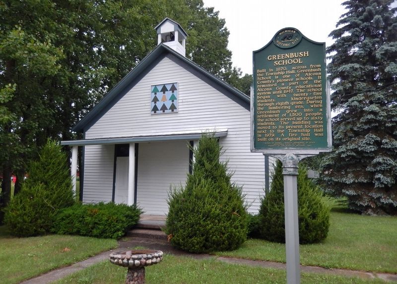
Greenbush School Marker (wide view; school building in background)
| On Campbell Street west of State Street, on the right when traveling west. |
| On North Lake Street 0.1 miles north of East Main Street, on the left when traveling north. |
| On Point Road east of Sturgeon Trailways Road, on the left when traveling east. |
| Near North 5th Street just north of West Jefferson Street, on the right when traveling north. |
| On East Dock Street 0.1 miles east of North Lake Street, on the left when traveling east. |
| On East Main Street east of North Lake Street, on the left when traveling east. |
| On West Main Street (Michigan Route 72) at North State Street (U.S. 23), on the right when traveling west on West Main Street. |
| On Point Road east of Spruce Trailways Road, on the left when traveling east. |
| On Point Road east of Spruce Trailways Road, on the left when traveling east. |
| Near Point Road east of Sturgeon Trailways Road, on the left when traveling east. |
| On Point Road east of Spruce Trailways Road, on the left when traveling east. |
| On Point Road east of Spruce Trailways Road, on the left when traveling east. |
| Near Point Road near Spruce Trailways Road, on the left when traveling east. |
| On Point Road east of Spruce Trailways Road, on the left when traveling east. |
| On Point Road east of Spruce Trailways Road, on the left when traveling east. |
| On Point Road east of Spruce Trailways Road, on the left when traveling east. |
| On Point Road east of Spruce Trailways Road, on the left when traveling east. |
| Near Point Road east of Sturgeon Trailways Road, on the left when traveling east. |
| On Dune Lane near Alcona Road and North Lake Shore Drive. |
| On Dune Lane at Alcona Road on Dune Lane. |
| On Point Road east of Spruce Trailways Road, on the left when traveling east. |
| Near State Highway 28 1 mile east of Arbutus Street (Autrain Forest Lake Road), on the left when traveling east. |
| Near State Highway 28 1 mile east of Arbutus Street (Autrain Forest Lake Road), on the left when traveling east. |
| On Autrain Forest Lake Road 2.2 miles south of State Highway 28, on the right when traveling south. |
| Near State Highway 28 1 mile east of Arbutus Street (Autrain Forest Lake Road), on the left when traveling east. |
| On Arbutus Street at Route 28, on the right when traveling north on Arbutus Street. |
| Near 2275B north of 2275. |
| Near Forest Road 2275B north of Forest Road 2275. |
| Near Forest Road 2275B north of Forest Road 2275. |
| On Log Slide Road north of County Route H58, on the right when traveling north. |
| Near Log Slide Road north of County Route H58. |
| On Grand Marais Avenue (County Road H-58) at Randolph Street and Crawford Street, on the right when traveling north on Grand Marais Avenue. |
| On Grand Marais Avenue (County Road H-58) at Randolph Street and Crawford Street, on the right when traveling north on Grand Marais Avenue. |
| On Grand Marais Avenue north of Randolph Street. |
| On Randolph Street at Crawford Street and Grand Marais Avenue (County Route H-58) on Randolph Street. |
| On Randolph Street at Lake Avenue ( Route 77), on the right when traveling east on Randolph Street. |
| On Veterans Drive east of Maple Street, on the left when traveling east. |
| Near Miners Castle Road north of Miners Beach Road. |
| Near Miners Castle Road north of Miners Beach Road. |
| Near Miners Castle Road near Miners Beach Road (County Route H11). |
| On West Munising Avenue (Michigan Route 28) near Hemlock Street, on the right when traveling west. |
| Near Miners Castle Road north of County Route 58. |
| Near Sand Point Road near Washington Street. |
| Near Elm Avenue 0.1 miles north of East Munising Avenue (State Highway 28), on the right when traveling north. |
| On Elm Avenue at East Chocolay Street, on the right when traveling north on Elm Avenue. |
| On East Superior Street at Elm Avenue, on the right when traveling east on East Superior Street. |
| Near Elm Avenue 0.1 miles north of East Munising Avenue (State Highway 28), on the right when traveling north. |
| On Sand Point Road near Washington Street, on the left when traveling north. |
| Near Chapel Road near Melstrand Road. |
| On Au Sable Point Trail (County Road H-58) 1.9 miles east of Sullivans Landing, on the left when traveling east. |
| On Traunik Road (County Road H-44) at E T Road (County Road H-01), on the left when traveling east on Traunik Road. |
| On Traunick Road (County Route H-44) just west of E T Road (County Route H-01), on the right when traveling west. |
| On Trowbridge Street at North Walnut Street, on the right when traveling west on Trowbridge Street. |
| On North Walnut Street at Trowbridge Street, on the right when traveling north on North Walnut Street. |
| On Hubbard Street at Chestnut Street, on the right when traveling west on Hubbard Street. |
| On Chestnut Street at Hubbard Street, on the right when traveling south on Chestnut Street. |
| On North Walnut Street 0.3 miles south of Trowbridge Street, on the right when traveling south. |
| On Walnut Street at Hubbard Street, on the right when traveling south on Walnut Street. |
| Near Brady Street east of Riverfront Plaza, on the right when traveling east. |
| On Hubbard Street at Chestnut Street, on the right when traveling east on Hubbard Street. |
| On North Walnut Street north of Hubbard Street, on the right when traveling south. |
| On State Street (2nd Street) south of Brady Street, on the left when traveling south. |
| On Riverfront Plaza west of Brady Street, on the right when traveling east. |
| On Center Street at Mixer Street, on the left when traveling east on Center Street. |
| Near West Center Street at Mixer Street. |
| On Center Street at Union Street, on the left when traveling east on Center Street. |
| On Center Street west of North Union Street, on the right when traveling west. |
| Near W. Center Street west of N. Union Street. |
| On Hamilton Street west of North Union Street, on the right when traveling east. |
| On Lakeshore Drive south of 123rd Avenue, on the right when traveling south. |
| Near W. Center Street at Blue Star Highway. |
| Near W. Center Street west of N. Union Street, on the right when traveling west. |
| On W. Center Street west of N. Union Street, on the right when traveling west. |
| Near Old Allegan Road 0.3 miles east of 58th Street. |
| Near Blue Star Highway (County Road A-2) 0.4 miles south of 124th Avenue (State Highway 89), on the left when traveling south. |
| Near Old Allegan Road 0.2 miles north of 57th Street, on the left when traveling north. |
| Near Old Allegan Road 0.3 miles east of 58th Street. |
| Near Old Allegan Road 0.3 miles east of 58th Street. |
| On W. Main Street (State Highway 89) west of Maple Street, on the right when traveling west. |
| On 38th Street 0.3 miles north of 144th Avenue, on the left when traveling north. |
| On Lincoln Road (Michigan Route 40) 1 mile north of 143rd Street. |
| On Ottogan Street (E. 32nd Street) 0.2 miles east of 52nd Street, on the right when traveling east. |
| On Church Street 0.1 miles south of 146th Avenue, on the left when traveling south. |
| On East 147th Avenue 0.5 miles east of South Waverly Road (54th Street), on the right when traveling east. Reported damaged. |
| Near Church Street 0.1 miles south of 146th Avenue, on the left when traveling south. |
| On 142nd Avenue 0.1 miles west of Beeline Road, on the right when traveling east. |
| On E. Main Street at Franklin Street, on the right when traveling east on E. Main Street. |
| On E. Main Street at Clark Street, on the right when traveling east on E. Main Street. |
| On E. Main Street at Franklin Street, on the right when traveling east on E. Main Street. |
| On 10th Street at Templeton Street, on the right when traveling north on 10th Street. |
| Near 10th Street north of Lee Street, on the right when traveling north. |
| Near N. Farmer Street (15th St) 0.2 miles north of River Street, on the right when traveling north. |
| On E. Allegan Street (State Highway 89) east of N. Fair Street, on the left when traveling east. |
| On Jefferson Road 0.1 miles west of 19th Street, on the right when traveling west. |
| Near N. Farmer Street south of Helen Avenue, on the left when traveling north. |
| On 142nd Avenue at 47th Street, on the right when traveling east on 142nd Avenue. |
| Near N. Main Street north of E. Bannister Street, on the right when traveling south. Reported permanently removed. |
| Near North Main Street just north of East Bannister Street, on the left when traveling north. |
| Near W. Allegan Street (State Highway 89) at W. Bridge Street, on the right when traveling east. |
| On Grand Street at Hoffman Street, on the left when traveling north on Grand Street. |
5972 entries matched your criteria. The first 100 are listed above.
Next 100 ⊳
