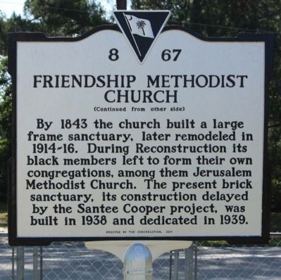
On Ranger Drive (State Highway 6), on the right when traveling south.
(Front text) This church, one of the oldest Methodist organizations in Berkeley County, was formally
organized about 1825. Circuit riders had preached in the area for more than forty years, and services held under a
brush arbor here . . . — — Map (db m55867) HM
On Black's Camp Road near lake front, west shore of Lake Moultrie, in the median.
Commander of Fort Sullivan and
the S.C. 2nd Regiment Jun. 17, 1775 to
Sept. 16, 1776. Governor of South
Carolina 1785-1787 and 1792-1794.
Defeated the British ships in 1776
in the invasion of the Charleston
Harbor. The fort's name was . . . — — Map (db m29432) HM
On South Carolina Route 45 at General Frances Marion Avenue, on the left when traveling north on South Carolina Route 45.
( Front Text ) Francis Marion
Brigadier General of S.C. militia during the American Revolution, Francis Marion, was one of the partisan leaders who kept the war alive during the British occupation of the state. His elusive . . . — — Map (db m22549) HM
Near end of General Francis Marion Avenue, on the right when traveling north.
(North face) Sacred to the Memory
of
Genl. Francis Marion,
Who departed his life, on the 27th of February, 1795,
in the sixty-third year of his age
Deeply regretted by all his fellow-citizens.
History will record his worth . . . — — Map (db m23902) HM
On Colonel Maham Drive at Westfield Drive, on the right when traveling south on Colonel Maham Drive.
Burial place of Col. Hezekiah Maham A native of St. Stephen's Parish Berkeley County, South Carolina Born 1739 Died 1789 He was a distinguished soldier and patriot of the American Revolution — — Map (db m54777) HM
On South Carolina Route 45 0.2 miles west of Colonel Maham Drive, on the right.
Maham Plantation. North of here was a plantation
owned by Hezekiah Maham (1739-1789). A legislator, soldier, and planter, Maham owned 500 acres in St. Stephen’s Parish by 1771 and eventually held dozens of enslaved people who grew rice in . . . — — Map (db m270287) HM
On South Carolina Route 45 0.1 miles west of Tower Hill Plantation Drive, on the left when traveling west.
Maude E. Callen (1898-1990) was born
in Quincy, FL. She received formal
training at Florida A&M Univ. and the
Tuskeegee Institute. In 1923, she and
her husband moved to Pineville, S.C..
where she worked as an Episcopal
missionary and one of . . . — — Map (db m270288) HM
On South Carolina Route 35 0.1 miles north of Route 45, on the right when traveling north.
In 1965, this was the Berkeley County
headquarters of Summer Community
Organization and Political Education
(SCOPE), a voter registration project
of the Southern Christian Leadership
Conference (SCLC). SCOPE recruited
volunteers from colleges . . . — — Map (db m270277) HM
On General Francis Marion Avenue, on the left when traveling north.
Disastrous American defeats during the Revolutionary War at Charleston and Camden in the summer of 1780 led many South Carolinians to give up the fight for independence. But Francis Marion carried on the struggle, waging a guerrilla war in the . . . — — Map (db m53957) HM
On General Francis Marion Avenue, on the left when traveling north.
For what he did in less than three years during the Revolutionary War, Francis Marion won enduring fame. By the nineteenth century he was remembered as the Swamp Fox, the partisan commander who always eluded the British and their Loyalist allies. . . . — — Map (db m53956) HM
On State Highway 45 at Old Canal Road, on the left when traveling north on State Highway 45.
“The Village of Eadytown is the site of the last known Indian tribe in Upper St. John’s Parish. In early 1700 American Settlers, moving inland, settled here and eventually became a vital part of the Community. Fort Schinkin, located on the . . . — — Map (db m54974) HM
On Matilda Circle Road (State Highway 8-204) at Walnut Way, on the left when traveling south on Matilda Circle Road.
(Front text)
Pineville, established in 1793-94, was one of the first planters' retreats in the South. James Sinkler built the first summer house here in 1793. Pineville, named for its "religiously preserved" pines and known for its "sweet . . . — — Map (db m23199) HM
On Pinopolis Road (State Highway 8-5) north of Fishburne Drive, on the right when traveling north.
Plantation owners began this pineland village in 1830s to escape lowcountry plantation summer nights, thought to cause "country fever" (malaria). By 1844 Pinopolis comprised about 12 homes. The village served as a shelter for refugees during the . . . — — Map (db m23422) HM
On Sugar Hill Drive (State Highway 8-5) near West Duke Road, on the right when traveling north.
This baptist Church, constituted 1851, constructed the present building here in 1881 on land donated by A.D. Hare, a church trustee. — — Map (db m23900) HM
On Ravenell Drive (South Carolina Route 45) at Pitts Street, on the left when traveling west on Ravenell Drive.
St. Stephen High School was
the first public H.S. for
white students in the town
of St. Stephen. The current
building was built 1928-29
and designed by Florence-
based architect Leon McDuff
Hicks. Bricks were made
locally at the . . . — — Map (db m270275) HM
On Old State Road (US 176), on the right when traveling south.
This county was designated a court and land conveyance district in 1682, and an election district in 1683. It was named for two brothers, Lord John and Sir William Berkeley, both Lord Proprietors of Carolina. Over the years, functions of this early . . . — — Map (db m30738) HM
On Old Gilliard Road (State Highway 27) north of Spring Hill Church Road, on the left when traveling north.
According to tradition, Methodists worshiped here under a brush arbor as early as 1800. On August 2, 1814, Phillip Keller deeded one acre for a Methodist Church and burying ground. Eden and Rebecca Green Thrower deeded an additional acre in 1839. A . . . — — Map (db m29703) HM
On State Highway 45, on the right when traveling west.
Named in honor
of
St. Stephen Native
Teacher and Principal
For Over 30 Years
Member
St. Stephen Town Council
1970-1979
Mayor Pro Tem
1974-1979
9th District member
S.C. Highway Commission
1972-1982
Member
House of . . . — — Map (db m29419) HM
On Mendle Rivers Road (State Highway 8-351) at Brick Church Circle, on the right when traveling south on Mendle Rivers Road.
Lucius Mendel Rivers (1905-1970), state representative 1933-36 and U.S. Representative 1940-70, was born in nearby Gumville and grew up on the family farm on Bonneau Road (now Mendel Rivers Avenue). Rivers attended the College of Charleston and the . . . — — Map (db m29330) HM
On Russellville Road (State Highway 8-18) at Cedar Drive, on the left when traveling west on Russellville Road.
St. Stephen Colored School St. Stephen Colored School, the first public African American school in St. Stephen, was built here in 1924-25. A three-room frame building, it was one of almost 500 schools in S.C. funded in part by the Julius . . . — — Map (db m29334) HM
On Church Road (State Highway 45) near Brick Church Circle Drive, on the right when traveling west.
St. Stephen’s, built 1767-69, is a fine example of the rural churches built in the S.C. lowcountry before the Revolution. “The Church is one of the handsomest Country Churches in So. Ca. and would be no mean ornament in Charleston,” the Rev. . . . — — Map (db m29329) HM
On Colonel Mamham Dr. at U.S. 52, on the right when traveling east on Colonel Mamham Dr..
The grave of Thomas Walter (c. 1740-1789), pioneer botanist, is 9 mi. W at his Santee River plantation. A native of England, Walter came to S.C. by 1769. He collected and catalogued many plants native to the lowcountry. His catalog Flora . . . — — Map (db m39003) HM
On North Main Street (U.S. 17A), on the right when traveling north.
This county was designated a court and land conveyance district in 1682, and an election district in 1683. It was named for two brothers, Lord John and Sir William Berkeley, both Lord Proprietors of Carolina. Over the years, functions of this early . . . — — Map (db m22948) HM
On Old State Road (U.S. 176) at Jericho Road (State Highway 9-26), on the right when traveling north on Old State Road.
Bishop Francis Asbury stopped in this region in 1801 and 1803. About 1811, a congregation was organized and by 1815 Jericho Meeting House was standing on land given by Jacob Felkel. The present building there was apparently erected before 1850. A . . . — — Map (db m26875) HM
On Mt. Lebanon Road 0.5 miles west of Old State Road (U.S. 176), on the right when traveling west.
This is the original site of Mt. Lebanon Lutheran Church, organized January 13, 1844, as an extension of the St. Matthew's Church, Creston. Later, Mt. Lebanon Church moved to Cameron about 2 miles NW, dedicated its new building in 1917, and was . . . — — Map (db m27239) HM
On Cameron Road (State Highway 33) near Nate's Store Road (State Highway 9-27), on the right when traveling east.
Shady Grove Methodist Church was an outgrowth of Tabernacle Church, the parent Methodist body of this area. It was built in the early 1800s on land of Adam Holman, has a framework of hewn logs held together with wooden pegs, and has been . . . — — Map (db m26201) HM
On Old State Road (U.S. 176) north of Old Orangeburg Road, on the left when traveling north.
This African Methodist Episcopal (AME) congregation organized in 1880 when five trustees acquired one acre of land at this site. The first church was a simple wood frame building. It was replaced by a more substantial wood structure, which had a . . . — — Map (db m292417) HM
On Old Number 6 Highway (State Highway 6) near Sherlock Road, on the left when traveling north.
In 1737-38, the elder Rev. John U. Giessendanner
from Orangeburg began Lutheran work in this
area; this was continued by his nephew until 1749.
By the 1760s, St. Matthew's Lutheran Church near
here was in use. A later building erected at . . . — — Map (db m26240) HM
On Fort Motte Road at Red Clay Road, on the right when traveling north on Fort Motte Road.
St. Matthew's Parish was established by the S.C. Colonial Assembly between 1765 and 1768. The first of four church buildings was erected in Amelia Township c. 1765. The parish church was incorporated by the S.C. General Assembly in 1788 as the . . . — — Map (db m237357) HM
On Old State Road (U.S. 176) at Old Swamp Road (State Highway 9-353), on the right when traveling west on Old State Road.
Sandy Run Church. This Lutheran church, one of the oldest in the state, is thought to have been organized ca.1765. By 1774, the Rev. Lewis Hochheimer was minister here. The church was incorporated in 1788 as "The German Lutheran Church of . . . — — Map (db m28827) HM
On Old State Road (U.S. 176) near Old Swamp Road (State Highway 9-353), on the left when traveling east.
Lutheran and Reformed (Calvinistic) Congregations were worshiping in a church three miles north of this site prior to the year 1751. The church was incorporated in 1788 under the name German Lutheran Church of Salem on Sandy Run but later came to . . . — — Map (db m28386) HM
On Old State Road (U.S. 21) 0.8 miles north of Savany Hunt Creek Road (County Highway 9-86), on the right when traveling north. Reported permanently removed.
This stream was originally called Savannah Hunt, but German-speaking settlers about 1740 corrupted the first word and Savany Hunt became the permanent name. — — Map (db m264926) HM
On McCord’s Ferry Road (State Highway 267) at Friendly Lane, on the right when traveling north on McCord’s Ferry Road.
The Good Hope Picnic, a celebration of the end of the planting season, is the oldest African-American event in the Lone Star community. Founded in August 1915 by farmers to market their produce and held on the second Friday in August, it has . . . — — Map (db m27879) HM
On McCords Ferry Road (South Carolina Route 267) at Dusty Lane, on the right when traveling south on McCords Ferry Road.
(side 1)
In 1841, St. Matthews Lutheran Church (5 mi. W) directed Rev. J.P. Margart to begin holding services in the nearby Pine Grove community. On September 27, 1847, congregants
formally organized as Pine Grove Lutheran Church. They . . . — — Map (db m220281) HM
On F R Huff Drive (State Road 9-46) south of Mill Road, on the right when traveling south.
Bethel A.M.E. Church was established in 1865 and held its early services under a brush arbor. Bethel was the first A.M.E. Church in Lewisville (now St. Matthews). Trustees Robin Amaker, Jack Dantzler, and Frank Keitt purchased land from Jacob G. . . . — — Map (db m292419) HM
On South Railroad Avenue (State Highway 9-48) at Dantzier Street, on the right when traveling south on South Railroad Avenue.
First settled in 1704, this region by 1733 included Amelia and lower Saxe Gotha townships. In 1765 much of it was made part of the new St. Matthew's Parish and was so named until 1865. Efforts in 1890 and 1896 led to an act signed on Feb. 14, 1908 . . . — — Map (db m26057) HM
On Old Number 6 Highway (State Highway 6) near Bluebird Trail, on the right when traveling south.
George Sterling was granted 570 acres of land here on March 14, 1704. During the lifetime of his daughter, Mary Sterling Heatly Russell, the plantation was a stopping place for Indians and travelers on the Cherokee Path. The Rev. John . . . — — Map (db m27218) HM
On Old Number 6 Highway (State Highway 6) at Bluebird Trail, on the right when traveling south on Old Number 6 Highway.
Ca. 1699 D. 1754
Mary Sterling Heatly
Russell Chapter
Honoring a pioneer woman
Mother of first white child
Born in
Calhoun - Orangeburgh Area — — Map (db m27215) HM
On Belleville Road (State Highway 9-45) at State Highway 601, on the right when traveling south on Belleville Road.
Governor of Georgia, 1777
A stern Revolutionary patriot
Born at Berchtesgaden, Austria in 1726
Brutally murdered by Tories
about 1782 near this spot — — Map (db m51711) HM
On Agnes Street at Buyck Street, on the right when traveling west on Agnes Street.
In 1954, this became the new site of John Ford High School, a segregated high school for African Americans. Previously known as St. Matthews Colored School and located on Herlong Ave., it was renamed for longtime principal John Andrew Ford . . . — — Map (db m292421) HM
On Fort Motte Road (State Highway 419), on the left when traveling south.
The first church built by African Americans at Fort Motte grew out of services held by slaves at nearby Bellville, Goshen, Lang Syne, and Oakland plantations. It was formally organized in 1867 by Caleb Bartley, Israel Cheeseborough, Cudjo . . . — — Map (db m26789) HM
On Old Belleville Road (County Route 24) north of Road 9-25, on the right when traveling north.
Organized in 1870 by freed slaves, this Baptist congregation is said to have first met in a brush arbor before temporarily worshipping in the balcony of nearby Buckhead Baptist Church, the nearby disbanded congregation of their former . . . — — Map (db m292422) HM
In Grateful Appreciation of the Services of the Patriots of Calhoun County 1775 - 1781
Gov. John Adams Treutlan •
Col. Wm. Thompson •
Maj. Lewis Colson •
Maj. Jacob Geiger •
Capt. Jacob Rumph •
Com. Alexander Gillam •
Capt. . . . — — Map (db m51702) WM
On Old State Road (U.S. 176) north of Shrike Road, on the right when traveling north.
Burial place of Lt. Col. Olin M. Dantzler, C.S.A. Appointed Brigadier General 1 June 1864 Defender of Charleston, SC and Petersburg, VA His recorded notes to General P.G.T. Beauregard led to the location of the submarine H.L. Hunley in 1995 Killed . . . — — Map (db m134424) HM
On Calhoun Road (State Road o-21) at Carr Street, on the right when traveling east on Calhoun Road.
In 1950, West End Calhoun County Library opened in a rented 4-room building off Calhoun Road to serve Black residents of Calhoun County. It was organized by local African Americans, who sought Calhoun County Co. Public Library (CCPL) support to . . . — — Map (db m292420) HM
On Sumter Highway (U.S. 521) at Brogdon Road, on the right when traveling north on Sumter Highway.
Wrongfully convicted,
illegally executed by South Carolina
Conviction vacated by court order
Dated December 16, 2014
A.N.D. June 2014 — — Map (db m252987) HM
On North Brewington Road (State Highway 14-50) 1.7 miles north of U.S. 301, on the right when traveling north.
On the night of October 25, 1780, Col. Francis Marion with 150 men surprised and completely routed 200 Torries under Col. Samuel Tynes near here. Marion's forces suffered no casualties. With the dispersion of Tynes's troops, Lord Cornwallis became . . . — — Map (db m261625) HM
On Kenwood Road near Henry Road, on the left when traveling west.
(Front) This cemetery was established about 1739 by Joseph Cantey (d. 1763), planter and member of the Commons House of Assembly. It is on the site of Mount Hope, Cantey's plantation near the Santee River. Cantey served what was then Craven . . . — — Map (db m53882) HM
On Patriots Road (State Highway 14-410) near Lesesne Drive (State Highway 14-480), on the right when traveling west.
During Francis Marion's 1781 campaign to drive the British from the Pee Dee, he and his men clashed near here in March with British and Tory forces numbering more than 500 men. During the Wyboo skirmish a Marion private, Gavin James, single-handedly . . . — — Map (db m24530) HM
Near Sunset Drive (U.S. 301) at South Boundary Street, on the right when traveling east.
William Dobein James, who rode with General Francis Marion during the Southern Campaign of the American Revolution, wrote in 1821 about L/C Tarleton following Marion "...as he (Tarleton) says, 'for seven hours, through swamps and defiles.' In fact . . . — — Map (db m161310) HM
On North Brooks Street (US 301 / 521) near West Rigby Street, on the left when traveling north.
During the American Revolution, December 1780, over 750 recently arrived British fusiliers were marching from Nelson’s Ferry on the Santee River. Major McLeroth’s British troops from Moncks Corner joined them as an escort to Camden. General Marion’s . . . — — Map (db m24370) HM
On Bozard Street east of South Mill Street ( Highway 260), on the right when traveling east.
During the American Revolution, the Bridges Campaign began March 6, 1781, with the Battle of Wyboo Swamp. Colonel Watson and British troops from Fort Watson were sent to crush General Marion. Marion’s Militia challenged them on the ¼ mile causeway . . . — — Map (db m227902) HM
On South Mill Street near Sunset Drive (U.S. 301), on the right when traveling south.
During the American Revolution, the militia like Marion's Brigade was totally dependent on a man with a horse and a gun who tended his farm and responded to Marion's call to arms. Marion rides this horse before battle at Black Mingo. Marion and . . . — — Map (db m24092) HM
On West Boyce Street (State Highway 261) at South Mill Street (State Highway 260), on the left when traveling west on West Boyce Street.
Clarendon County Five SC governors have come from this area, which was part of the Parish of St. Mark (1757) and Camden District (1769) before becoming Clarendon County in 1785. The county was then part of Sumter circuit court district (1799) . . . — — Map (db m23494) HM
On West Boyce Street (State Highway 261), on the left when traveling west.
(North face) CSA
Erected
to the
soldiers
from Clarendon
County
Who served in The War
for Southern
Independence.
Charleston - 1861
Appomattox - 1865.
(East face)
Hope, like the eastern sun,
rose bright in . . . — — Map (db m23744) HM
On West Boyce Street (State Highway 261), on the left when traveling west.
Emblem: American Legion
US Coast Guard - US Merchant Marine
Dedicated to the Memory of
all members of
the Armed
Services who
gtave their lives
in service of
their county
and to all
members of the
Armed Services
who . . . — — Map (db m224598) HM
On Dinkins Street near Grace Street, on the right when traveling west.
(Front text)
This church was founded about 1869 by Mary Scott “Aunt Mary” Harvin, and held its first services in a nearby brush arbor. In 1881 church trustees purchased a one-half acre lot here from Dr. J.G. Dinkins for . . . — — Map (db m51850) HM
On North Mill Street at Rigby Street, on the left when traveling south on North Mill Street.
During the American Revolution, 1780, General Marion and the men of his Brigade pushed back the British forces in the Black and Santee River Basins. It is unlikely that they thought they would be remembered by future generations. It may be that . . . — — Map (db m49051) HM
On East Rigby Street at North Brooks Street, on the left when traveling west on East Rigby Street.
The photograph above, taken about 1935, depicts the original gasoline station on this site. In 1939, Gulf Oil Corp. replaced it with a “modern” porcelain station, complete with wash and grease bays, and it occupied this corner until it, . . . — — Map (db m52265) HM
On North Brooks Street (U.S. 301/521) near Oak Street, on the left when traveling north.
Hanna Levi Memorial Library
The Hannah Levi Memorial Library, built
in 1909-1910, grew out of a library fund
begun in 1905 by the children of Moses
and Hannah Levi, along with proceeds
from the sale of Moses Levi Memorial
Institute. A . . . — — Map (db m24625) HM
On South Mill Street (State Highway SC260) at W. Hospital Street, on the left when traveling north on South Mill Street.
During the American Revolution, General Marion and his Militia needed help from local farmers for food, horses and medical care for wounds and diseases. Those shot or sick were left at the mercy of comrades and sympathy of Patriots. Medical care was . . . — — Map (db m93817) HM
On Greeleyville Highway (U.S. 521) at Mallett Road (State Highway 14-384), on the right when traveling east on Greeleyville Highway.
Named in 1979 in honor
of
Jesse Lywood Mallett
Born 1924 Died 1979
Deputy Sheriff
Clarendon County
1975 — 79
Killed in line of duty
April 28, 1979
in truck - patrol car
accident
through no fault of his
A dedicated, . . . — — Map (db m24851) HM
Near Old Georgetown Road west of North Brooks Street (U.S. 301), on the left when traveling west.
(side 1)
The Manning Collegiate Institute, the town’s first public school opened here in early 1890. The two-story frame school with a bell tower, built in 1889-1890, was called “one of the most handsome and imposing” buildings in . . . — — Map (db m224596) HM
On Weinberg Street north of West Boyce Street, on the left when traveling north.
(side 1)
Manning Training School has origins in the early 20th century with the Slater Fund helped finance Clarendon County Training School. This facility provided both education for black students and advanced training for African . . . — — Map (db m224599) HM
On North Brooks Street (U.S. 301) north of West Boyce Street ( Highway 261), on the left when traveling north.
Chartered by acts of the General Assembly beginning March 8, 1741 with title vested successively in Joseph Murray • Theodore Gaillard • James Hunter, Trustee • Adam McDonald • Theodore Gourdin and William Staggers.
Upon the death of Staggers . . . — — Map (db m227893) HM
On US 301 & US 521, on the left when traveling north.
On the night of November 7, 1780, Lt. Colonel Banastre Tarleton and his Green Dragoons—together with Harrison’s Provincials, a large unit of Tories from the area between the upper Santee and Wateree Rivers—camped at the plantation of the late . . . — — Map (db m51985) HM
On L and H Pearson Road 0.1 miles south of Costello Road, on the right when traveling south.
Pearson Family Homesite. This farm was home to the family of Levi Pearson (1894-1970), who with his brother, Hammett Pearson, joined other African American parents in Davis Station and Jordan protesting Clarendon Co. schools' refusal in the . . . — — Map (db m199865) HM
On US 301 at Joe Marie Road, on the right when traveling south on US 301.
Black institute built soon after school district purchased the land in 1933. School closed in 1953 with 5 teachers/ 159 students. Now a community center. — — Map (db m24158) HM
After the American Revolution, General Marion’s militiamen re-built his home. Francis Marion, at age 53, married Mary Esther Videau, April 20, 1786. They lived at Pond Bluff, on the south edge of the Santee Swamp and raised pineland cattle. With . . . — — Map (db m43156) HM
On South Boundary Street at West Boyce Street ( Highway 261), on the right when traveling north on South Boundary Street.
During the American Revolution, on Nov. 8, 1780, General Francis Marion and his brigade lured British Colonel Tarleton and his Green Dragoons about 26 miles from Jack's Creek through the swamps to Ox Swamp, less than 1 mile east of here. After . . . — — Map (db m227852) HM
On North Brooks Street (U.S. 301/521) near Rigby Street, on the right when traveling south.
During the American Revolution, after the fall of Charleston in 1780, Francis Marion burst forth to lead the Williamsburg militia. He was the senior Regimental Continental Officer not captured or paroled. He recruited patriots, ambushed the British . . . — — Map (db m23987) HM
On West Rigby Street near North Mill Street, on the right when traveling west.
This church was founded soon after the Civil War
by 50 freedmen and woman who held their first
services in a stable donated to them by S.A. Rigby.
In 1869 the church trustees bought a half-acre lot
for a school, and in 1870 they bought a . . . — — Map (db m24626) HM
On Patriot Road (State Highway 14-410) at Wyboo Road on Patriot Road.
In March 1781, Lord Francis Hastings Rawdon, the British commanding officer in Charleston, designed a two-pronged assault against the forces of General Francis Marion. From Camden, Col. Welbore Ellis Doyle and the Volunteers of Ireland moved east . . . — — Map (db m51986) HM
On Black River Road (South Carolina Route 527) 0.1 miles south of June Burn Road, on the right when traveling south.
Midway Presbyterian Church overlooks the cemetery where two Revolutionary War soldiers are buried, William McIntosh and John J. Reardon. At age 16, McIntosh joined General Francis Marion's "Little Band of Patriots." In 1801 he helped organize and . . . — — Map (db m258651) HM
On Paxville Highway (State Highway 261) at U.S. 15, on the right when traveling east on Paxville Highway.
During the American Revolution, November 1780, Colonel Tarleton with his Green Dragoons hunted General Marion. Tarleton encamped at the late General Richardson’s home. Marion was warned by the widow's son and quickly withdrew to the east of Jack's . . . — — Map (db m23958) HM
On Old River Road (State Highway 14-76) 1 mile south of Governor Richardson Road, on the right when traveling south. Reported permanently removed.
(front)
Encounter at Halfway Swamp
On December 12, 1780, according to tradition, British Maj. Robert McLeroth was surprised near here by Gen. Francis Marion. The British first agreed to a staged combat with twenty men on each side, . . . — — Map (db m43328) HM
On Old River Road (State Highway 14-76) 1 mile south of Governor Richardson Road, on the right when traveling south.
(side 1)
Encounter at Halfway Swamp
On December 12, 1780, according to tradition, British Maj. Robert McLeroth was surprised near here by Gen. Francis Marion. The British first agreed to a staged combat with twenty men on each . . . — — Map (db m227896) HM
On Old River Road at Elliots Landing Road, on the right when traveling south on Old River Road.
In December 1781, Maj. Robert McLeroth and the 64th Regiment were conducting newly-arrived British army recruits of the Royal Fusiliers from Charleston to the High Hills of Santee. Learning of McLeroth’s movement, Col. Francis Marion led some 700 . . . — — Map (db m227715) HM
On Old River Road (State Highway 14-76), on the right when traveling south.
Three hundred yards west is the site of one of the earliest graveyards in St. Mark's Parish.
In the cemetery are buried Richard Richardson, Brigadier in the Revolution, James Burchell Richardson, South Carolina Governor 1802-04, and John Peter . . . — — Map (db m23495) HM
On State Highway 527, on the left when traveling north.
Midway Presbyterian Church, named because of its location halfway between Salem and Williamsburg Churches, traces its beginning to 1801, when services were being held under a brush arbor. The earliest building was erected in 1802, and the Rev. G. G. . . . — — Map (db m27780) HM
On Liberty Hill Road (State Highway 14-373) near Old River Road, on the left when traveling north.
Liberty Hill ChurchIn 1867, five years after the Emancipation Proclamation, Thomas and Margaret Briggs gave four acres of land to this African Methodist Episcopal church. The present building, completed in 1905, has been brick veneered. Meetings . . . — — Map (db m24058) HM
On Larry King Jr. Drive near 4th Street, on the left when traveling east.
"Together let us sweetly live" Distinguished Followers of Justice Briggs VS. Elliott Rev. Joseph A. Delaine; Mr. Hammett Pearson; Mr. Levi Pearson; Mr. Harry Briggs; Mr. Joseph Lemon; Pioneers in the School Desegregation Case; Historical plaintiffs . . . — — Map (db m52315) HM
23 April 1781
American Forces
led by
Brig. Gen. Francis Marion
"The Swamp Fox"
South Carolina Militia -
Commander [Marion picture included]
LTC Henry "Lighthorse Harry" Lee
Lee's Legion
British Forces
led by . . . — — Map (db m24418) HM
On H.T. Everetts Road (State Highway 14-306) near Pulitzer Road , Richbourg Lane (State Highway 14-258), on the right when traveling east.
According to local tradition, this Methodist congregation was organized in 1786 and pioneer American bishop Francis Asbury later visited the area a number of times. The church stands today on land given by Ellis R. and Mary A. Richbourg in 1880. . . . — — Map (db m24465) HM
On Church Street (U.S. 301) near Burgess Street, on the right when traveling north.
This is the childhood home of Anne Custis Burgess, who was born in 1874 in Mayersville. After receiving a diploma from Converse College, she taught music at Summerton, Williamston, and Winthrop College. At the time of her death in 1910 she was . . . — — Map (db m24528) HM
On Delaiane Street at Hill Street, on the left when traveling west on Delaiane Street.
(Side 1)
Briggs Family House
On November 11, 1949, local African American families came to this house to sign a petition demanding equal resources in Summerton's racially segregated schools. Believing the homes isolated location . . . — — Map (db m199859) HM
On Liberty Hill Road (State Road 140373) 0.8 miles north of Bynum Road, on the left when traveling north.
Butler Cemetery. This cemetery dates to at least the 1860s and likely began as a burial ground for white members of the Butler and Nelson families. By the turn of the 20th century it was a community cemetery for local African Americans who . . . — — Map (db m301500) HM
On South Church Street (U.S. 15) near Main Street (U.S. 301), on the right when traveling north.
During the American Revolution, General Marion’s Brigade eluded the British invaders. Marion’s Militia slipped through swamps, trees and grasslands, enticing the British to follow and search along the Santee.
In November 1780, the British sent . . . — — Map (db m93772) HM
On Fort Watson Road (State Highway 14-803) 1 mile west of St Paul Road (U.S. 15/301), on the left when traveling west.
One of the chain of British posts in South Carolina. Located on this Indian Mound. Besieged April 15-23, 1781 by use of Maham's tower, Francis Marion forced the British to surrender and secured for his men badly needed ammunition and supplies. — — Map (db m300988) HM
On Fort Watson Road (State Highway 14-803), on the left when traveling west.
The first post in S.C. retaken from the British, the stockade fort on this old Indian mound had controlled the road from Charleston to Camden as well as the Santee River. On April 15, 1781, Gen. Francis Marion and Lt. Col. Henry Lee encircled it . . . — — Map (db m301930) HM
On St. Paul Road (U.S. 301/15), on the right when traveling north.
Assigned to hold all of eastern South Carolina but with only a small force at his disposal, Col. John Watson needed to build a fort to protect the vital transportation corridor between Charleston and Camden, the British inland headquarters. The spot . . . — — Map (db m51477) HM
On 4th Street at Larry King Highway, on the left when traveling north on 4th Street.
Mr. Harry and Eliza Briggs, a family of strong faith, were one of the first families to sign the petition. Meetings were held in their homes as well as St Mark AME, and Liberty Hill AME. These gatherings were held in secrecy to find twenty parents . . . — — Map (db m233255) HM
On 4th Street at Larry King Highway, on the left when traveling north on 4th Street.
Mr. Levi Pearson, Sr. was a farmer and a humble man of strong faith and integrity, who believed in fairness. He initiated the fight to improve educational opportunities in Clarendon County in 1947 by asking Clarendon School District 26 to provide . . . — — Map (db m233256) HM
[Front] This church, organized about 1865, held its early services in a nearby brush arbor but built a permanent sanctuary here soon afterwards. Rev. Daniel Humphries, its first pastor, served both Mt. Zion and its sister church St. James . . . — — Map (db m27783) HM
307 entries matched your criteria. Entries 101 through 200 are listed above. ⊲ Previous 100 — Next 100 ⊳