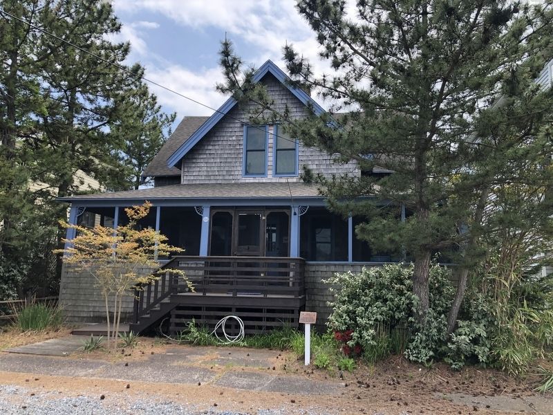
The first of 5 houses built by John M. Addy of Pittsburgh, PA. It later became "Williams Inn," renting room from the 1930's until 1975. — — Map (db m150143) HM
The 4th of 5 houses built by John M. Addy, Pittsburgh, PA — was one of the "Six First Families". Considered as his masterpiece, it was one of the 1st homes to have indoor plumbing. In 1935 it was converted to a guest house and is now operated as a . . . — — Map (db m198878) HM
Completed July 8, 1910, the Loop Canal marked the end of a long journey for vacationers traveling to Bethany Beach in the town’s early days. Arriving in Rehoboth by railroad, travelers would continue their voyage by boat, crossing Rehoboth and . . . — — Map (db m37155) HM
Built in 1930 by Thomas Granville Walston and his wife Minnie Ann and located on the boardwalk between First and Second Streets. Later owned and operated by their daughter and son-in-law, Zada and Bill Wilgus who occupied the apartment above. It . . . — — Map (db m150140) HM
Surf fishing is a Delaware tradition older than the beach parks themselves.
Decades of cooperation between surf anglers, DNREC Division of Parks and Recreation, elected officials, and other concerned citizens have created perfect conditions . . . — — Map (db m206352) HM
Built by Senator Louis Drexler, Pittsburgh, PA. Moved back from the beach 3 times. A 2nd floor balcony surrounds the living room. — — Map (db m150145) HM
Built in 1903 by William R. Errett, Pittsburgh, PA, one of the "Six First Families." Its original design has been maintained and is the only one of the first cottages still in the same family. — — Map (db m150144) HM
The Indian River Inlet has not always existed in its current location. This barrier beach environment is dynamic, and the opening to the inlet has opened and closed at different locations.
When the inlet closed, navigation, water quality, . . . — — Map (db m206345) HM
Originally owned by Robert Lattimer, whose will bequeathed the house to Ethel Palmer and Caroline Sloan on condition they remain unmarried. As Caroline Sloan eventually married, Ethel Palmer became heir to the home that has continued to remain in . . . — — Map (db m150142) HM
Built in 1923 by Raymond Ringler at this location. Movies were shown, accompanied by refreshments, followed by dancing to the music of a local band. Destroyed during the storm of 1944, it was later replaced by the "Blue Surf" motel until 2008. — — Map (db m150138) HM
There is an ocean current that moves sand parallel to the coast known as the "littoral drift" or "longshore current." Along most of coastal Delaware, this current moves in a northward direction. As it moves north, it moves sand. There is so much . . . — — Map (db m206344) HM
Built in the early 1900's at 2nd Street and the beach by R.R. Bulgin, a Disciples of Christ Preacher and named the Bellevue-Atlantic Hotel. 1915 purchased by John Addy and renamed Seaside Inn. Subsequent owners Cal and Alice Jagger provided room and . . . — — Map (db m150141) HM
Built in the mid-1920's by Priney Townsend, Ocean View, DE. In 1950 the house was turned 180° and a full length deck facing the ocean was added. — — Map (db m150146) HM
The first restaurant on Bethany's boardwalk. Built in 1933 and destroyed by fire in 1953. Became the Holiday House under owners Karl Klais and James Popham who rebuilt again after the storm of 1962. 1984 owned by Arnold Brown it became the first . . . — — Map (db m150139) HM
Since World War I, more than 92,000 American soldiers are unaccounted for.
This unoccupied seat is dedicated to the memory of these brave men and women and to the sacrifices each made in serving our country.
God Bless You. God Bless . . . — — Map (db m150137) WM
The present inlet was formed in 1929 and was widened and stabilized by the Corps of Engineers from 1938-1940. The first three bridges that spanned the inlet were plagued by a series of failures due to environmental and meteorological conditions. . . . — — Map (db m108109) HM
The Faithful Steward, bound from Londonderry, Ireland to Philadelphia, ran aground on a shoal September 1, 1785 with 249 passengers aboard. Stormy weather drove the vessel toward shore where it became stranded in 4 fathoms (24 feet) of water . . . — — Map (db m108226) HM
Prior to 1775 this hundred was claimed as part of
Worchester County, Maryland being named for Lord
Baltimore. After boundary line between Maryland
and Delaware was confirmed, Baltimore Hundred became
part of Sussex County, Delaware. — — Map (db m37404) HM
Not so long ago—around the 1920's—the shores of Pepper Creek were lined with abundant saltmarshes. These tidal wetlands stabilized coastal woodlands like you are walking through today at DBG, which in turn protected inland properties. . . . — — Map (db m302733) HM
Settled at the site of a gristmill on Pepper Creek,
this village was originally known as Blackfoot
Town. The present name of the community is
derived from that of John Dagsworthy. A New
Jersey native who moved to this area in the
mid- 18th . . . — — Map (db m37239) HM
For many years local Methodists were forced to
travel a considerable distance to attend services.
In 1873, Houston’s School House was established
as a preaching place within the local circuit.
The success of this effort stimulated interest
. . . — — Map (db m61105) HM
A Garden to Teach and Inspire
Dogfish Head Craft Brewery made the Learning Garden a possibility when they purchased the naming rights to make this critical DBG educational venue. Construction of the Dogfish Head Learning Garden began on . . . — — Map (db m302731) HM
Since World War II, more than 82,000 American soldiers are unaccounted for.
This unoccupied seat is dedicated to the memory of these brave men and women and to the sacrifices each made in serving our country.
God bless you. God bless . . . — — Map (db m198873) WM
Before the settlement of the boundary dispute between Delaware and Maryland, this area was considered to lie in Maryland. On July 5, 1755, responding to the request of members of the Church of England residing in the upper portion of Worcester . . . — — Map (db m39556) HM
In 2020, in partnership with the Center for the Inland Bays (CIB) and DNREC, over 300' of DBG's Pepper Creek southeast edge was restored using a natural living shoreline approach to preserve and protect the eroding tidal saltmarsh. In 2023, a . . . — — Map (db m302735) HM
The Rev. Edward Dingle of England settled at Dagsboro, Del. Nov. 11, 1753, also built St. Martin's Church, Worcester Co. MD. 1756 completed 1759. He died 1763 and was buried with his wife under St. Martins pulpit as was the English custom. — — Map (db m190339) HM
Named in honor of notable Delawarean. John M. Clayton, the Clayton Theatre was first owned and operated by Alvin "Sheet" Campbell and wife Marjorie, with brother-in-law Elwood "Pete" Hancock and wife Marian. Constructed in 1948 by W. Benjamin Dorey, . . . — — Map (db m245582) HM
A Garden to Teach and Inspire
Dogfish Head Craft Brewery made the Learning Garden a possibility when they purchased the naming rights to make this critical DBG educational venue. Construction of the Dogfish Head Learning Garden began on . . . — — Map (db m302732) HM
A Model for Stormwater Management
You are viewing the Delaware Botanic Gardens "Rhyne Garden," designed in the likeness of the original Delaware system of drainage conveyances and named for the Welsh "rhewyn," a canal whose function was . . . — — Map (db m302736) HM
In honor of those who paid the supreme sacrifice in World War II
Reginald M. Layfield • William H. Morris • Randall C. Joines
and in memory of those who served in World Wars I and II — — Map (db m198874) WM
“…whenever they sounded the alert button, bells rang or something went off. I had to run there to the tower up the ladders.”
—William Smith, 261st CA, remembering his role as a range sergeant in a 2004 interview
For generations, this tower . . . — — Map (db m268383) HM
The Indian River Inlet has not always existed in its current location. This barrier beach environment is dynamic, and the opening to the inlet has opened and closed at different locations.
When the inlet closed, navigation, water quality, . . . — — Map (db m150130) HM
There is an ocean current that moves sand parallel to the coast known as the "littoral drift" or "longshore current." Along most of coastal Delaware, this current moves in a northward direction. As it moves north, it moves sand. There is so much . . . — — Map (db m150128) HM
Built from 1939 to 1942, the 11 concrete observation towers along Delaware's coast were built to protect the shores during World War II - and to last about 20 years. They are still standing after 60 years. The towers were the eyes for the guns of . . . — — Map (db m268382) HM
In the 1870s, the United States Life-Saving Service (USLSS) was established to aid the victims of shipwrecks on American shores. The service featured a network of stations, with seven or eight men — called surfmen — who lived . . . — — Map (db m150127) HM
The smallest, flattest and driest continent on earth is about the same size as the United States. Settled 200 Years ago by a contingent of outcasts and criminals from Great Britain, Australia is now populated by 16 million "ockers" and ten times . . . — — Map (db m206327) HM
On December 29, 1858, the Lighthouse Board issued the following announcement:
“Notice to Mariners
New Light-House
at
Fenwicks Island, Delaware”
Notice is hereby given that the new tower at Fenwicks Island, Delaware, is finished, . . . — — Map (db m63345) HM
This is the marker from which Charles Mason and Jeremiah Dixon started the survey for the famous Mason-Dixon Line that separates Delaware from Maryland, Pennsylvania, and New Jersey.
This marker was settled in 1750 by John Emory and Thomas . . . — — Map (db m95336) HM
The Fenwick Island Lighthouse
Erected 1858
In operation from 1859 to 1978
as an official aid to navigation
Transferred to Delaware, 1981
Restored, 1982 – 1983, by The Friends of
the Fenwick Island Lighthouse under the
leadership of . . . — — Map (db m3027) HM
The Fenwick Island Lighthouse was listed in the National Register of Historic Places by the Department of Interior in 1979 in recognition of its significance of the rich maritime history of Delaware.
In 1852, responding to pressure to . . . — — Map (db m63347) HM
This stone monument, erected April 26, 1751, marks the eastern end of the Transpeninsular Line surveyed 1751-1751 by John Watson and William Parsons of Pennsylvania and John Emory and Thomas Jones of Maryland. This line established the east-west . . . — — Map (db m1234) HM
In the 17th century, the colony of Maryland was founded as a refuge for Catholics and members of other religious faiths then subject to persecution. Many of the early settlers of this region, then a part of Maryland, were Presbyterians who had been . . . — — Map (db m122258) HM
In the heart of the untamed wilds, nestled amidst dusty plains and giant critters, lay the peculiar town of Nugget Hollow. Founded by a motley crew of adventurous guinea pigs, Nugget Hollow boasted a bustling community centered around a . . . — — Map (db m302725) HM
The roots of this congregation can be traced to the late 1700’s, when Methodist pioneers such as Francis Asbury and Freeborn Garrettson visited this area to propagate the faith. Meetings were held in the open air and in private residences. By 1816 a . . . — — Map (db m38381) HM
The roots of African-American Methodism in this area can be traced to the late 18th century when Methodism pioneers such as Francis Asbury and Freeborn Garrettson traveled locally organizing black “classes” for worship. Over time some groups chose . . . — — Map (db m37844) HM
A "society" of the African Methodist Episcopal Church was established in this area by the 1830's. The first church was purchased in 1857. On February 28, 1890 land was purchased at this site for the purpose of construction of a new church. Annual . . . — — Map (db m37323) HM
After adventurous service as a sea captain during the late 19th and early 20th centuries, Captain Ebe Townsend Chandler returned to his hometown of Frankford and purchased what is now known as the Captain Chandler House in 1918. Built by Captain . . . — — Map (db m190329) HM
In 1819, a group of Methodists purchased a parcel of land north of present-day Frankford. A frame chapel was erected, and on March 4, 1820, the members of the congregation met there to elect trustees and formally organize themselves as Antioch . . . — — Map (db m37256) HM
By the 1840’s, a group of local Methodists were meeting nearby in Jones School. Desiring a permanent place of worship, the congregation built a church in 1857
at a site one-half mile west of here. In 1861, Jacob Jones and his wife, Love . . . — — Map (db m48566) HM
In 1881 the Nanticoke Indian people constructed
this church to provide a place to join for religious
devotions. Known as “Johnson’s Chapel,” the church
was affiliated with the Methodist Protestant
denomination. On March 27, 1884, the land . . . — — Map (db m37564) HM
During the late 17th and early 18th centuries,
a great number of settlers came to this area
from the lower Eastern Shore counties of
Maryland and Virginia. They brought many
elements of their culture including an
affiliation with the . . . — — Map (db m38196) HM
Part of the 'Youngs Hope' Plantation granted by Gov. Andros of New York in 1675. Peter Marsh purchased a portion & built the Homestead in 1743. From 1871 William A. Dodd and his heirs owned and farmed it. In 1929 W. S. Corkran acquired it & during . . . — — Map (db m258116) HM
This Memorial Garden Honors all of the American Military Men and Women who have Paid and Continue to Pay the Ultimate Sacrifice to Protect our Country and Ensure our Freedom.
The centerpiece of this memorial, a beautiful obelisk atop a structure of military sandbags, was built by the 512th Maintenance Squadron, Dover Air Force Base, Delaware, and retired Chief Master Sergeant, First Sergeant, Michael Bellerose. The . . . — — Map (db m272544) HM WM
Delaware State Senate President Pro Tempore David B. McBride served as chair of the Senate Natural Resources Committee for 25 years. Before, during and after his time as chair, the senator, a life-long Delawarean, has been a steadfast and unwavering . . . — — Map (db m272527) HM
Built from 1939 to 1942, the 11 concrete observation towers along Delaware's coast were built to protect the shores during World War II - and to last about 20 years. They are still standing after 60 years. The towers were the eyes for the guns of . . . — — Map (db m272521) HM
On February 9, 1838, a meeting was held at the Angola Schoolhouse for the purpose of formally organizing a Methodist Episcopal Church to serve the needs of local residents. On that same day the congregation's newly-elected trustees received a deed . . . — — Map (db m232972) HM
Theodore C. Freeman – Lewes Native
Ted Freeman was born in Haverford, Pennsylvania on February 18, 1930 but his family moved to Lewes, Delaware before he was 18 months old. Freeman was educated at Lewes schools and graduated in 1948 from . . . — — Map (db m227859) HM
In 1840, Israel United Methodist Church formed in the Belltown community west of Lewes. Israel established a cemetery in 1854 and formally incorporated in 1877. The congregation rebuilt the church in 1890 and again in 1916. Over time, the 1916 . . . — — Map (db m227870) HM
Located within this neighborhood, a short distance south of here, is the burial ground of the Coursey and Daisey families, members of the Nanticoke Indian tribe.
The graveside is unmarked except for a family tombstone noting the site.
It . . . — — Map (db m104206) HM
In 1769, an international scientific effort was organized to observe a transit of Venus in order to determine the size of the solar system. This rare event, when Venus passes in front of the Sun's disk, makes such calculations possible when measured . . . — — Map (db m228456) HM
Guns such as these were used as field artillery. There were four 155mm guns placed at Fort Miles and four more placed across the Delaware Bay at Cape May, NJ to limit access to the bay. The concrete pads the were placed on were called "Panama . . . — — Map (db m150111) HM
When Fort Miles was completed, its two 16-inch guns were some of the largest artillery ever engineered by the United States and were placed here to defend the coastline from enemy battleships.
This particular gun barrel is Barrel 371, . . . — — Map (db m150114) HM
This gun is known as a 3"/50, which specifies diameter of the gun's bore and it's caliber. The 3-inch guns that were placed at Fort Miles were mounted on a pedestal to allow them to be easily aimed and follow the target. Throughout their use, . . . — — Map (db m150104) HM
The gun before you is a 6-inch pedestal-mounted deck gun. This gun could fire two types of rounds, a 105-lb. armor-piercing round and a 90 lb. high-explosive round.
The model 1903-A2 guns that were at Fort Miles would have been mounted on . . . — — Map (db m150115) HM
The 8-inch guns placed at Fort Miles were each mounted on a railcar, making the large guns very mobile and easy to position for firing. The gun was able to turn in a 360° circle at an elevation of 45°. This made them difficult targets for enemy . . . — — Map (db m150112) HM
During World War II, the U.S. Coast Artillery used batteries, or groups, of four 90mm guns (two mobile and 2 fixed) in Anti-Motor Torpedo Boat/Anti Aircraft roles. Fort Miles had three such batteries during the 1940s. Batteries 5A and 5B were . . . — — Map (db m272522) HM
From the end of World War I until the beginning of World War II, advances in design and engineering led to advances in aircraft and military transportation in general. This progress created more versatile vessels such as aircraft carriers and . . . — — Map (db m150107) HM
This casemate, named Battery Hunter was built in World War II to house two 6-inch guns. The bunker, 15 acres of surrounding land and 500 feet of beach surrounding it was occupied by the Navy from 1950 until 1981.
Many of the European immigrants who came to this country at the end of the nineteenth century brought with them a variety of epidemic diseases including cholera, typhus, smallpox and bubonic plague. This posed a serious threat to urban areas such as . . . — — Map (db m39387) HM
Each spring, upon arrival from their Central and South American wintering grounds, Delaware beachnesters establish colonies and take part in courtship rituals. The birds lay their eggs in shallow nests scraped into the sand mostly between the . . . — — Map (db m94322)
Long ago, this area was a freshwater marsh. It lay protected from ocean storms by the Great Dune and barrier beaches. As sea levels rose, saltwater marshes replaced freshwater marshes.
Starting in the 1800s, locals extracted salt from . . . — — Map (db m232983) HM
The guns in this park serve as representations of the artillery that was here throughout Fort Miles' World War II years; these are not the actual guns and not the same models as the guns that were placed here.
Fort Miles was part of the . . . — — Map (db m150109) HM
This small group of buildings, or cantonment, provided living space and necessary services for the troops assigned to operate the guns of Fort Miles. Concrete barracks were more comfortable than the canvas and wood structures that were . . . — — Map (db m150102) HM
The troops stationed here during World War II were part of the nation's coastal defense system that protected the mouth of the Delaware Bay and industries located up the Delaware River. Later the U.S. Army used the area as a recreation center . . . — — Map (db m150103) HM
Just before World War II, the U.S. War Department began upgrades of the harbor defenses that protect the Delaware Bay. They built new fortifications here at Cape Henlopen that became known as Fort Miles. The fort grew as the members of the . . . — — Map (db m150101) HM
On May 14, 1945, the officers and crew of the German submarine, U-858 gave themselves up to U.S. Marines after hearing of Germany's surrender to Allied troops. They and their vessel were escorted here to the Fort Miles Army dock. Crew members . . . — — Map (db m39382) HM
Herring Point is named for Battery Herring, which housed two 6-inch guns during World War II as part of the United States coastal defense. At the close of that war and during the Cold War, the site was used for top secret military tests and . . . — — Map (db m272539) HM
Noted painter Howard Schroeder (1910-1995) was assigned to Fort Miles in 1941. That first winter, soldiers lived in tents or a large warehouse because barracks were still under construction. Schroeder painted fellow soldiers as well as the . . . — — Map (db m272540) HM
The piece of steel before you is a 48-inch section of armor plate that is 17.5 inches thick. The hole in it was created by a Mark 8, 16-inch armor piercing shell weighing 2,700 lbs. fired at point blank range. Firing shells at a piece of . . . — — Map (db m150113) HM
In 1880, the fear that foreigners were bringing epidemic diseases to the United States led the federal government to create the National Quarantine System. Around the country, from stations like the one that was here, doctors were dispatched to . . . — — Map (db m39385) HM
Civilian volunteers of the U.S. Army Ground Observers Corps (GOC), a branch of the Aircraft Warning System (AWS) used buildings like this during World War II. The AWS used different types of buildings, including dedicated office buildings, . . . — — Map (db m150106) HM
Built from 1939 to 1942, the 11 concrete observation towers along Delaware's coast were built to protect the shores during World War II - and to last about 20 years. They are still standing after 60 years. The towers were the eyes for the guns of . . . — — Map (db m39595) HM
Built from 1939 to 1942, the 11 concrete observation towers along Delaware's coast were built to protect the shores during World War II - and to last about 20 years. They are still standing after 60 years. The towers were the eyes for the guns of . . . — — Map (db m232986) HM
For more than 150 years, the Cape Henlopen Lighthouse guided ships into Delaware Bay on their way to the ports of Wilmington and Philadelphia.
The Cape Henlopen Lighthouse had its beginnings in 1761. Philadelphia merchants and ship owners . . . — — Map (db m79167) HM
Cape: a piece of land jutting into a body of water beyond the rest of the coast line; a headland; a promontory. Delaware's coastline is constantly changing. The daily effects of wind, tidal currents, and wave action are reshaping and redesigning the . . . — — Map (db m39388) HM
You are standing on the Great Dune, the largest sand hill between Cape Cod, Massachusetts, and Cape Hatteras, North Carolina. This is the dune's highest point, about 80 feet above the Atlantic Ocean.
It took thousands of years and the . . . — — Map (db m79166) HM
The Osprey or Fish Hawk is found April through October in both salt and freshwater areas of the state. Almost as large as a Bald Eagle, the Osprey looks like a cross between a hawk and a gull.
Osprey can spot fish from extreme heights. . . . — — Map (db m94323)
The United States Navy's ties to Cape Henlopen spanned nearly 100 years. The Navy first came to the Cape in 1898 to build a signal tower during the Spanish American War. In the 20th century, the Navy kept a communications station he, beginning with . . . — — Map (db m79201) HM
This stretch of shoreline is known to many as "Whiskey Beach." The history behind that name is a little cloudy. Some say that during Prohibition days in the 1920s, this was a rendezvous for rumrunners. Such an isolated site could have been an . . . — — Map (db m232978) HM
When Bill Hopkins came to Delaware in 1964 as the first superintendent for Cape Henlopen State Park, he brought with him a vision that would shape preservation in the state for years to come. For more than forty years he has been a driving force . . . — — Map (db m150116) HM
Named for the river branch which runs along its northwest edge, Cool Spring Presbyterian Church was established circa 1726. Many of its members were Ulster Scots who had come to America from Ireland seeking religious freedom and economic . . . — — Map (db m150096) HM
Established in 1870, the Cool Spring Station operated as a freight stop on the Junction & Breakwater Railroad (J&BRR) at the northeast corner of the present-day intersection of Cool Spring Road and Lewes Georgetown Highway. During the late . . . — — Map (db m190425) HM
302 entries matched your criteria. The first 100 are listed above. Next 100 ⊳