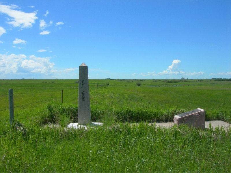
The monument erected here marks the intersection of the boundary between Manitoba and Saskatchewan with the International Boundary and was placed by joint effort of the International Boundary Commission and the Manitoba-Saskatchewan Boundary . . . — — Map (db m285368) HM
This plaque and gateway are dedicated to the memory of the pioneers of the Winlaw District who with faith and foresight planned this church and cemetery in 1886. Erected on land donated by I. Guthrie, Winlaw Presbyterian Church
was officially . . . — — Map (db m286081) HM
Erected to Commemorate
Winlaw School and District No. 143 Organized 1888.
Classes held in Winlaw Church until school built
1900, S.E. 20. Moved to this
site 1925. Closed 1958. — — Map (db m286082) HM
The 250 mile trail linking Wood Mountain with Fort Qu’Appelle passed this site. From about 1850, Indians, hunters, traders, missionaries, mounted police and pioneers transported pelts, pemmican and provisions over its length. From Wood Mountain . . . — — Map (db m203787) HM
In memory of 1914 — 1918 Askin R. • Bowden J. S. • Green H. • McCrady R. E. • McGillivray G. A. Perkins F. G. • Perkins T. A. • Reid D. P. • Walker F. Erected & unveiled by Milestone Community Club June 3, 1928. 1939 . . . — — Map (db m209030) WM
The unusual circular lake seen to the west, was created as the
result of collapses in the geological formation beneath the lake. A
potash-rich, prairie evaporite salt formation 915 metres below the
surface underlies most of southern . . . — — Map (db m286089) HM
”Let those not be forgotten who bravely took part in the fight for Democracy.” Anderson, Carl • Armstrong, Allan • Armstrong, Douglas • Armstrong, Kenneth • Bachorcik, Paul • Bachorcik, Steve • Barbour, Archie • Barnstable, Orville • Berg, . . . — — Map (db m203767) WM
In 1931, the coal miners of South East Saskatchewan organized to improve conditions in the mines for themselves and their families. On September 29th, on this site brothers Peter Markunas, Nick Nargan and Julian Gryshko died in the struggle and . . . — — Map (db m203782) HM
This building, completed in 1930, is the last court house designed by Saskatchewan’s Provincial Architect, Maurice Sharon. Faced with Estevan pressed brick, it is a fine example of the Colonial Revival style. In 1931, miners in the Estevan area . . . — — Map (db m203775) HM
One of the most important early trails passed at this point. Linking the early Metis settlements at Wood Mountain and Fort Qu'Appelle, it was in frequent use from the 1860's. In 1881 Sitting Bull, the famous Sioux Leader. Passed over this trail . . . — — Map (db m205104) HM
The Bell Farm once occupied the surrounding district. It was controlled by the Qu’appelle Valley Farming Company and managed by Major W. R. Bell. Between 1882 and 1889 the company settled more than 100 tenant farmers on 53,000 acres. Farming was . . . — — Map (db m200759) HM
In 1882 the Qu'Appelle Valley Farming Company launched an ambitious 53,000 acre (21,500 hectare) corporate farming enterprise in the Indian Head district. The operation quickly became known as the Bell Farm, after the company's major shareholder . . . — — Map (db m200761) HM
In 1925 Provincial Architect Maurice Sharon developed a standard plan for judicial buildings in smaller urban centres. Half the size of his previous court houses, these structures were erected at Gravelbourg (1926), Shaunavon and Wynyard (1927), . . . — — Map (db m205157) HM
The beautiful Qu’Appelle Valley was formed by the waters of Glacial Lake Regina and the South Saskatchewan River which cut into the deposits left by the glacier to form the valley. Glacial Lake Regina was formed along a part of the front of a . . . — — Map (db m211647) HM
To commemorate one hundred years of Confederation July 1, 1867 — July 1, 1967 the following projects were constructed in Crescent Park Art Museum • Outdoor Swimming Pool • Natatorium Renovations • Park Lighting • Park Sprinkling System • Landscape . . . — — Map (db m289134) HM
The opening of Moose Jaw's central fire hall in 1910 was a long-awaited event. The fire hall was designed in 1907 but construction was delayed when city council spent two years searching for the right building site.
At the time of its opening, . . . — — Map (db m196929) HM
Architect: David Ewart, Ottawa • Contractor: McDiarmid & Co., Winnipeg
The Dominion of Canada's Chief Architect adapted his standard Public Building design (similar buildings remain in Vancouver, Lethbridge and Regina) to create a . . . — — Map (db m196925) HM
Architects: Sholto Smith, Moose Jaw • W.A. Elliott, Brandon
Contractor: Navin Brothers
After a 2-year delay in building, while city council searched for an appropriate site, the Fire Hall was constructed featuring a 60-foot hose . . . — — Map (db m196928) HM
When CPR construction reached here in September 1882, this view was part of a hay flat in the broad valley of Thunder Creek.
Main Street divided the two sections of land reserved for the Moose Jaw townsite. In the beginning, the thoroughfare “was . . . — — Map (db m196924) HM
[left side] Originally constructed by the Royal Bank of Canada in 1914, at a cost of $100,000, this terra cotta clad Beaux-Arts structure subsequently served for a time as home to the Bank of Montreal until 2008, when it was . . . — — Map (db m288898) HM
The Moose Jaw courthouse, completed in January 1909, is the oldest continuously functioning provincial court building in Saskatchewan. It replaced an earlier wood frame Court House at High Street and 9th Avenue which was built in 1893 and demolished . . . — — Map (db m288976) HM
Moose Jaw Court House
This building is the first example of the system of new
district facilities commissioned by the Government of
Saskatchewan after the formation of the province in
1905. Completed in 1909, it is atypical of . . . — — Map (db m288977) HM
Private George Price was born on December 15th 1892 in Kings County, Nova Scotia. As a young man he moved to Moose Jaw, Saskatchewan. He enlisted in the 210th Infantry Battalion (Frontiersmen), Canadian Expeditionary Force (C.E.F.) in Moose Jaw on . . . — — Map (db m202457) HM
Architect: Reid & McAlpine, Moose Jaw • Contractor: Peter Lyall & Sons, Montreal
In1911, the Andrew Carnegie Foundation, skeptical of Moose Jaw's population claims, refused a request for a $50,000 library grant. Undaunted, the city . . . — — Map (db m196926) HM
Erected by the Pense Branch Canadian Legion in lasting memory of their comrades who made the supreme sacrifice 1914-1918 1939-1945 lest we forget. — — Map (db m201009) WM
In 1883, the famous Cree Chief Piapot came into conflict with the CPR in this vicinity. He and his people camped in the middle of the projected right-of-way and refused to move. Construction was held up for some time until the Crees were persuaded . . . — — Map (db m289821) HM
In 1883 Piapot led his band in an act of non-violent resistance against the railway and the Europeans coming into Cree Lands. They would pull up the survey stakes and place teepees in the path of the Canadian Pacific Railway track laying crews. He . . . — — Map (db m290054) HM
The "76" Ranch took its name from the brand used by the Powder River Ranch in Wyoming. When Sir John Lister-Kaye bought the ranch’s entire herd of cattle for his land development, he kept the brand and took the name “76”. This was the site of the . . . — — Map (db m201571) HM
In 1884, Sir John Pepys Lister-Kay, a Yorkshire Baronet, arrived in the Northwest from California, bought 7,000 acres of land near Balgonie, and started a farm. In 1886, Lister-Kaye became interested in the Swift Current area. He bought ten . . . — — Map (db m201573) HM
During the 1870’s, as the vast buffalo herds disappeared, ranchers came to this area to fill the empty prairie with cattle and horses. The arrival of the North-West Mounted Police, who established posts at nearby centres like Fort Walsh, helped . . . — — Map (db m201581) HM
Albert Branch Library was built in 1927 on the site of one of Regina's first branch libraries. The architect Joseph Warburton used a Gothic theme in the entranceway with Tyndal stone details highlighting the windows and roofline.
This plaque was . . . — — Map (db m196918) HM
Connaught Branch Library was built in 1930 to provide a public library service in this area. The architect Joseph Warburton highlighted this public building with classical Tyndal stone details details surrounding the entranceway.
The building is . . . — — Map (db m196919) HM
[English] Residence of the Lieutenant Governors of the North-West Territories (1891-1905) and Saskatchewan (1905-1945), Government House is one of the few surviving territorial buildings and was for many years the hub of official social life . . . — — Map (db m196906) HM
[English] Thousands of Canadian nurses have provided skilled and compassionate care to the sick and wounded in battle since 1885. In 1904, professional nurses entered the Canadian Army Medical Corps as Nursing Sisters. They were the . . . — — Map (db m201376) HM WM
Constructed between 1907 and 1910, the Regina Land Titles Building was the first public building commissioned by the newly-established Province of Saskatchewan. Designed by the prominent Toronto architectural firm of Darling and Pearson, the . . . — — Map (db m196921) HM
Originally, settlers in and around Regina thought of Wascana Creek in practical terms. The creek was first dammed in 1883, creating the reservoir now known as Wascana Lake. The reservoir provided the settlement with the only substantial body of . . . — — Map (db m196903) HM
In 1903 the Province of Saskatchewan was created from the North-West Territories. Three years later the government Premier Walter Scott chose the form of Edward and W.S. Maxwell of Montreal to design a new legislative building for the Province. . . . — — Map (db m289887) HM
This building, designed by Regina architects Storey and Van Egmond, was constructed in 1914 as the head office of the Saskatchewan Co-operative Elevator Company. Established in 1911, the company was one of the first major farmer co-operatives and . . . — — Map (db m196920) HM
In 1883 the CPR and its business partner, the Canada North-West Land Company, spent more than $14,000 in the new Regina town site digging a well, grading five streets, and building a dam. That dam was the first control structure on Pile of Bones . . . — — Map (db m196905) HM
Telephones were introduced into Saskatchewan in the early 1880’s, but it was not until 1908 that a government agency was created to manage them. Constructed in 1924, this structure was the first official head office for Saskatchewan Government . . . — — Map (db m289100) HM
This bridge was built as an unemployment relief project during the Great Depression and was formally opened on November 10, 1930, by Premier J.T.M Anderson. It was dedicated as a memorial to the Saskatchewan soldiers who fell in the First World . . . — — Map (db m291198) HM
Chief Payepot was a proud leader known for his wisdom, spirituality and fearlessness. As the leader of the Young Dog Society, he led buffalo hunting parties across the Western Plains. Herds of buffalo in the millions roamed the prairies and were . . . — — Map (db m289145) HM
[English] The province of Saskatchewan, formerly of the North West Territories, was created on 1 September, 1905, and inaugurated on this site by Governor General Earl Grey and Prime Minister Sir Wilfred Laurier on 4 September, . . . — — Map (db m201271) HM
Walter Scott, a prominent journalist and politician, was raised in rural Ontario. In 1885 he moved west and, as a member of Parliament (1900-1905), played a leading role in achieving provincial status for Saskatchewan. Appointed its first Premier . . . — — Map (db m215979) HM
This 1894 parish church was built for the Anglican Diocese of
Qu'Appelle to replace the original church built in 1883, and
dedicated on Thursday January 24, 1895, the Eve of the Feast of
the Conversion of Saint Paul. It was never intended to be . . . — — Map (db m289895) HM
The Metropolitan Methodist Church was constructed in 1906 and partially destroyed by the Regina tornado of 1912. The present building, designed by architects Francis Portnall and J.H. Puntin, represents a traditional blend of Norman and Gothic . . . — — Map (db m291195) HM
In 1906 the Winnipeg-based Northern Bank commissioned its architects, Blair and Northwood, to design its new Regina Branch building. The result was this structure, with its classical revival facade. It is Regina’s oldest downtown commercial . . . — — Map (db m291197) HM
Between 1857 and 1860 a British funded expedition led by Captain John Palliser sought to increase scientific knowledge of the Canadian west. When the group reached what is now the Regina area their September 1857 journal entry talked about . . . — — Map (db m291280) HM
Seat of Territorial Government
On March 27, 1883, Regina was named capital of the North-West Territories, and on August 20 Lieutenant Governor Edgar Lewdney first met with his council in the Council Chamber constructed on this . . . — — Map (db m288974) HM
You are standing on the second meridian, which is one of the main control lines for surveys in this Province. The second meridian is a true north line established from the Canada - United States boundary to Saskatchewan's North-East corner. From . . . — — Map (db m288795) HM
The Saskatchewan Air Ambulance service, born under the reign of T.C. (Tommy) Douglas, Premier of Saskatchewan made its' first flight February 3, 1946. The crews faced the extremes of Saskatchewan weather, often flying in near impossible . . . — — Map (db m205049) HM
This cairn marks the site of the village of Ettington and where for 20 years McGuire’s Store was the heart of the community. Formed in 1913 with the arrival of the C.N. rail line, Ettington at one time had a population of 130 people. The community . . . — — Map (db m205018) HM
An Indian legend from the 1800s reveals how Old Wives Lake, to the west, was named. One winter a Cree party went beyond their traditional area in search of buffalo. They ventured into territory claimed by both the Cree and Blackfoot.
The Cree were . . . — — Map (db m204855) HM
Weyburn Court House was designed by Provincial Architect Maurice Sharon in a distinctive Colonial style. Constructed in 1928, this elegant building expressed the confident aspirations of Saskatchewan towns in the last good harvest year before the . . . — — Map (db m203784) HM
The Mortlach Fire Hall and the bell played an important part in the early days of Mortlach's settlement and development. The Fire Hall was built in 1911.
The lower hall housed the horse drawn water tank and hose, which along with volunteers was . . . — — Map (db m196922) HM
This marker at the Third Meridian, which is a major control survey line upon which the survey of Saskatchewan’s lands to the west depends, honors the work of pioneer surveyors who overcame great difficulties in establishing a vast survey system on . . . — — Map (db m202460) HM
(top plaque)
Gondney School District 3781 br>
Established in June 1916. This school district was named from Goudney, Manitoba. The 'u' being mistaken for 'n'. The school, contracted by Waterman-Waterbury, was built in 1917 one mile . . . — — Map (db m205154) HM
Born on January 9, 1881 at Willow Bunch (Talles Des Saules). Edouard was the eldest son of Gaspard Beaupre and Florentine Piche, Willow Bunch pioneers.
He died of lung hemorrhage, caused by tuberculosis while working for Ringling Brothers at . . . — — Map (db m205162) HM
Trader and pioneer settler of Willow Bunch, where he opened a post in 1880, Jean-Louis Légaré, a native of Québec, had entered the fur trader at Wood Mountain in 1870. He became the trusted friend and unofficial spokesman for the . . . — — Map (db m205198) HM
This park dedicated by the Town of Whitewood to Mayor Fred J. Hack, founder, in appreciation of his outstanding contributions to the community. July 15, 1973. — — Map (db m209039) HM
In early twentieth century Saskatchewan, optimism was a chief driving force for many communities. Reflecting the view that growth was inevitable, many towns and cities built elaborate Town Hall-Opera House structures. Wolseley commissioned Manitoba . . . — — Map (db m200632) HM