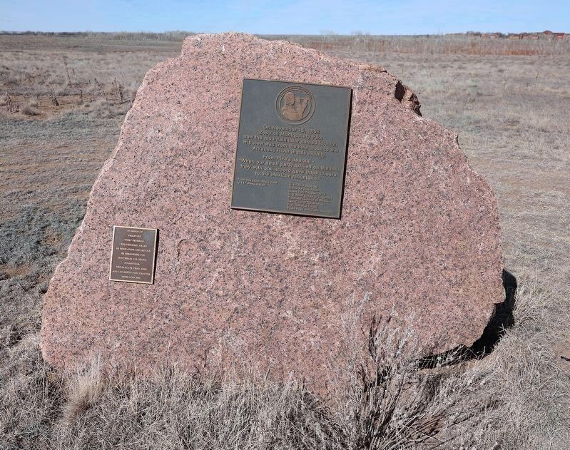
Near County Road Ff.5 5 miles east of Colorado State Highway 101 and Bent County Road FF.
On November 15, 1806, Zebulon Montgomery Pike saw the mountain later named for him. His view was from the hills close to the Arkansas River in this vicinity.
From Pike's journal—
“When our small party arrived on the hill, they with one . . . — — Map (db m268907) HM
Dinosaur Freeway Geology of John Martin Reservoir
is part of the Dakota sandstone
formations which extend from Denver,
Colorado to Tucumcari, New Mexico.
In the Cretaceous period the region
was bordered with lakes, swamps . . . — — Map (db m181091) HM
On Colorado Route 101 0.6 miles south of County Road 10.75, on the right when traveling north.
This tablet is the
property of the State of Colorado
—
Boggsville
Established in 1866.
Named for Thomas O. Boggs,
first settler on this site.
Home of Kit Carson and
John W. Prowers, noted . . . — — Map (db m119664) HM
Near Colorado Route 101 1 mile south of County Road 10.75.
"...On crossing the river [Purgatoire] we found a large well-filled ranch...which had only just been built by two enterprising Yankees.:"
–William Bell, railroad surveyor, 1867
Boggsville was established in the early . . . — — Map (db m120701) HM
Near Carson Avenue (Colorado Route 101) north of 8th Street, on the right when traveling north.
This region was once buffalo hunting grounds for the Cheyenne, Apache, Arapaho, Kiowa and Comanche. Tribes followed the buffalo throughout the plains and controlled the land. During this time, everything south of the Arkansas river was Mexico and . . . — — Map (db m120709) HM
Near Colorado Route 101 1 mile south of County Road 10.75, on the left when traveling south.
The Arkansas River Valley is a historical frontier in both the American and European sense. Americans view the frontier as unsettled or a sparsely settled area lands on the edge of "civilization." To Europeans, frontiers are boundaries or borders . . . — — Map (db m120698) HM
On Highway 160 at County Road 450, on the right when traveling east on Highway 160.
Slow down! Take time to taste the Cuchara River Valley Cuisine and enjoy the talents of more than 100 working artists. A remarkable system... of more than 500 igneous dikes that radiate out 25 miles from the Spanish Peaks led to the . . . — — Map (db m281409) HM
On U.S. 160 at County Road 450, on the right when traveling east on U.S. 160.
The Legend of El Grandote When the young Mexican, El Grandote, left his home to look for gold in the Wayatoyas (The Spanish Peaks), leaving behind Nana, his wife, and their unborn child. One night he saw Nana in a dream, and realized she was . . . — — Map (db m281298) HM
On Interstate 25 at milepost 59, 0.3 miles north of County Road 103, on the right when traveling north.
Here, in the shadow of the Spanish Peaks and the Wet Mountains, stands El Huerfano - "the orphan." This stark and lonely volcanic outcrop, named in the late 1700s by an unknown Spanish trader, had for centuries guided earlier Hispanos and . . . — — Map (db m97717) HM
On John F. Kennedy Memorial Highway (Interstate 25), on the right when traveling north.
The isolated cone-shaped butte, east of this point and 10 miles north of Walsenburg, was named El Huerfano, “The Orphan,” by early Spaniards. The name appeared in Spanish records as early as 1818. This butte was near the Trappers’ Trail . . . — — Map (db m64793) HM
On Main Street (Business Interstate 25) just north of East 5th Street (U.S. 160), on the right when traveling north.
This pioneer Huerfano County family, whose political, business, and social contributions were a major factor in the growth and development of Walsenburg, were in continuous residence here from 1872 to 1980. — — Map (db m281294) HM
On Main Street (Business Interstate 25) just north of East 5th Street (U.S. 160), on the right when traveling north.
Walsenburg is named for Fred Walsen, a German immigrant who settled here in 1870 and leased the land for the first major coal mine. But the community was actually founded by Don Miguel Antonio Leon, a rancher who led several dozen Mexican . . . — — Map (db m281301) HM
Near Forest Road 2185 east of Rourke Road (County Highway 25).
This replica is an exact copy of a large dinosaur bone unearthed in 2008 from a quarry located in Picket Wire Canyonlands. Apatosaurus is among the most massive land animals ever to exist. A member of the long-necked, plant-eating dinosaur is called . . . — — Map (db m184919) HM
Near Forest Road 2185 east of Rourke Road (County Highway 25).
This Catholic church and cemetery are important components of the small Hispanic community in Picket Wire Canyonlands dating from the late 1870s through 1890s. In 1889, Damacio Lopez, the original owner, sold this land to Reverend Bishop Mattz of . . . — — Map (db m182455) HM
Near Forest Road 2185 east of Rourke Road (County Highway 25).
Farmhand to Cattle Baron Eugene Rourke was born on St. Patrick's Day in 1849 in Wicklow County, Ireland. The younger of 10 children, Eugene and his
family immigrated to La Salle, Illinois in 1852. Tragically, his
parents died . . . — — Map (db m181884) HM
Today the Purgatoire River rolls through a rugged, arid landscape in a deeply carved
canyon—but imagine a lush conifer forest and verdant ferns right where you're standing!
Learning from the Layers
The layers of rock at the . . . — — Map (db m181056) HM
Near Forest Road 2185 east of Rourke Road (County Highway 25).
The Rourke Ranch Historic District, listed on the National
Register of Historic Places in 2000, is a striking example of a late
19th century cattle ranching enterprise. The ranch played a significant role in the settlement and . . . — — Map (db m181947) HM
A famous discovery was made right here along the Purgatoire River! During the Jurassic Period, hundreds of dinosaurs once inhabited this area when it was a vast lake. As they plodded through the mud along the lakeshore, the dinosaurs left behind . . . — — Map (db m181254) HM
From the air, you can see
the tracks of two sauropod
dinosaurs walking side by side
along the ancient lakeshore. The
discovery that some types of
dinosaurs lived in large herds like
modern animals happened because
of parallel tracks . . . — — Map (db m181013) HM
A day of festivity was followed by one of the darkest in American Labor history.
The state militia was on guard
Because tensions between the strikers and the company had been steadily escalating, the state militia was stationed on . . . — — Map (db m100513) HM
On County Highway 44 at County Highway 61.5, on the right when traveling west on County Highway 44.
Most miners lived in company-owned towns like Berwind.
The miners often lived in company-owned towns near the mines where they worked.
Because of their isolated location, miners were forced to buy provisions at company stores, live in . . . — — Map (db m193636) HM
On County Highway 44 at County Highway 61.5, on the right when traveling west on County Highway 44.
Excavations of the Ludlow tent cellars permitted archaeologists to contribute to the historical record.
The cellars provided the most comprehensive snapshot of daily life in the tent colony.
The goals of archaeology at Ludlow were to . . . — — Map (db m193557) HM
On County Highway 44 at County Highway 61.5, on the right when traveling west on County Highway 44.
The legacy of those who fought and died in the strike is evident in workplace rights enjoyed today.
Miners lost the strike but paved the way for labor reform.
The coalfield strike ended in December, 1914, when the UMWA was forced to . . . — — Map (db m193556) HM
On County Highway 44 at County Highway 61.5, on the right when traveling west on County Highway 44.
Between 1997 and 2002 archaeologists studied the living conditions of miners in southern Colorado.
Archaeologists carried out excavations at the Berwind coal camp and the Ludlow tent colony - two sites from the 1913-1914 Colorado coalfield . . . — — Map (db m193558) HM
On County Highway 44 at County Highway 61.5, on the right when traveling west on County Highway 44.
Even though conditions were harsh, colonists forged friendships and a sense of community.
Approximately 1200 people lived in 200 tents made of canvas and wood.
Based on excavations, tents averaged 10 x 14 feet in size and were . . . — — Map (db m193627) HM
On County Highway 44 at County Highway 61.5, on the right when traveling west on County Highway 44.
The following statements are from people who were involved with the tragedy. They come from official records and oral histories.
"They used to scrub by hand, go fetch the water a mile [or] two, [at] 3:00 in the morning. We used to make . . . — — Map (db m193570) HM
On April 20, 1914, the State Militia unleashed an un-warranted attack on striking coal miners and their families living in a tent colony at this site. Eleven children and two women suffocated in a cellar beneath a tent when flames engulfed the . . . — — Map (db m100509) HM
On County Highway 44 at County Highway 61.5, on the right when traveling west on County Highway 44.
History often neglects or omits the 1913-1914 Colorado coalfield strike and massacre
Looking onto this prairie, you see one of several places where coal miners lived during the strike.
Miners demanded better wages, an eight-hour work . . . — — Map (db m193668) HM
On County Highway 44 at County Highway 61.5, on the right when traveling west on County Highway 44.
The United Mine Workers of America has fought for workers rights at home and abroad.
The UMWA accepts all mine workers regardless of race, religion or national origin.
The UMWA was founded in Columbus, Ohio, on January 22, 1890. It . . . — — Map (db m193590) HM
On U.S. 350 at milepost 15, on the right when traveling north.
On the morning of 21 August 1944, two B-24 Liberator Bombers collided in mid-air and plunged to earth killing eighteen men.
Crew of 42-51517
Lt. Horace M. Jenkins, Cheyenne, WY
Capt. Royal J. Brock, Columbus, OH
Lt. Clair A.Clark, . . . — — Map (db m77885) HM WM
On U.S. 350 at milepost 15, on the right when traveling north.
Trail of Commerce
The heavily laden freight wagons traveled in parallel columns to minimize dust and for convenience when circling the wagons at night or when danger threatened. A circle of wagons provided a fine defensive position. But the . . . — — Map (db m77883) HM
On U.S. 350 at milepost 15, on the right when traveling north.
Bent's Ranch on the Purgatoire River
In the fall of 1846, William Bent, supervising partner of Bent's Fort, selected a site on the Purgatoire River, about five miles downstream from here, to create one of Colorado's first farming-ranching . . . — — Map (db m77886) HM
On East Main Street (Business Interstate 25) at North Commercial Street, on the right when traveling west on East Main Street.
Before homesteaders began farming the plains, before barbed wire sliced the prairies into neat squares, and before windmills spiked the horizon, huge open-range ranching operations controlled thousands of square miles of grasslands. Enormous herds . . . — — Map (db m280698) HM
On West Main Street (U.S. 160) at North Beech Street, on the right when traveling west on West Main Street.
In the late 1860s, directly across the street stood the Colorado Hotel, a two-story adobe building fronted by a wooden arcade. It was the station for the Denver Santa Fe Stage Line and, for several days, the refuge of some 60 Anglo town residents . . . — — Map (db m100505) HM
At a time when the military banned women, former slave Cathay Williams disguised herself as a man and enlisted in the all-Black 38th Infantry in 1866. She served honorably as Pvt. "William Cathay" for nearly two years. Ready to give up army life, . . . — — Map (db m135774) HM
On West Main Street (U.S. 160) at North Convent Street, on the right when traveling west on West Main Street.
South West Side (front)
Coal Miners' Memorial
Southern Colorado Miners Memorial 1996
Ben Johnson - Artist
Thomas S. Espinoza •
Charles Dintelman •
Mike Butero •
Paul Butero, Sr. •
Jasper Butero, . . . — — Map (db m100504) HM
On West Main Street (Business Interstate 25) just west of North Commercial Street, on the left when traveling east.
Established in 1973, this National Historic District encompasses about 40 irregularly shaped city blocks in the Heart of Trinidad. The first log cabins and adobe houses were built here in 1861. Most of the existing buildings were constructed . . . — — Map (db m282383) HM
On South Chestnut Street just south of East First Street, on the right when traveling north.
Erected through the cooperation of Federal, State and local governments by Works Progress Administration. Dedicated to the enrichment of human lives. A record of permanent achievement. — — Map (db m282499) HM
On North Commercial Street just south of Church Street, on the right when traveling north.
From this spot in August 1846, you could have watched a U. S. Military Force invading the Republic of Mexico. The U.S. Army of the West was already well into Mexican territory, for the International Boundary was then the Arkansas River, about 80 . . . — — Map (db m281896) HM
On North Commercial Street at West Plum Street, on the right when traveling south on North Commercial Street.
Commercial Street, which you are now facing, is a paved-over wagon trail that was here before the town was built. It was one path of the Mountain Route of the famed Santa Fe Trail. Thousands of ox-drawn freight wagons rumbled past here from 1821 . . . — — Map (db m281682) HM
On Interstate 25 at milepost 0, on the right when traveling north.
"Raton" is Spanish for "Mouse".
On mountain branch Santa Fe Trail.
Crossed by Kearny's Army of the
west in the Mexican war and by
first regiment, Colorado Volunteers
in the civil war. "Uncle Dick"
Wooten's toll road built 1865.
Railroad . . . — — Map (db m77853) HM
On East First Street at South Maple Street, on the left when traveling west on East First Street.
With the faith and courage of their forefathers who made possible the freedom of these United States, the Boy Scouts of America dedicate this replica of the Statue of Liberty as a pledge of everlasting fidelity and loyalty.
40th . . . — — Map (db m280496) HM
Near Interstate 25 Frontage Road when traveling north.
Panel 1
Road to Santa Fe
"...for it begins upon the outside line of the outside State (Missouri) and runs directly toward the setting sun..." - Sen. Thomas Hart Benton, following the Santa Fe Trail survey, 1825
For . . . — — Map (db m97715) HM
This monument
marks the route of the
Santa Fe Trail
1822 - 1879
placed by the
Daughters of the
American Revolution
and the
State of Colorado
It also commemorates
the faithful work of
Harriett Parker Campbell . . . — — Map (db m77856) HM
On South Maple Street at East 3rd Street, on the left when traveling north on South Maple Street.
Jews have been part of Trinidad's social, economic and political life since first arriving as traders along the Sante Fe Trail. Maurice and Isaac Wise opened a store on Main Street in 1867. The Jaffa Brothers' Trading Company was established in . . . — — Map (db m135690) HM
On East Main Street (Business Interstate 25) just west of North Commercial Street, on the right when traveling west.
Trinidad is uniquely blessed to have over 100 years of its history preserved in photographs taken by a father-son team of camera artists, Oliver and Glenn Aultman, ably assisted by their wife and mother, Jennie. Through the years, their camera . . . — — Map (db m282473) HM
On North Commercial Street just south of West Plumb Street, on the left when traveling north.
The two-story building across the street, with ornate lintels above its windows and a pressed-tin cornice, was built in 1883 by one of Trinidad's most famous citizens, Casimiro Barela. Known as the Perpetual Senator because he served in the state . . . — — Map (db m280697) HM
On West Main Street (U.S. 160) at North Convent Street, on the right when traveling west on West Main Street.
For centuries, miners have been taking canary birds down into their mines to warn them of potential disaster. If a tunnel or shaft collapses or is blocked, thereby diminishing the oxygen supply, the canary will be the first to react, usually dying, . . . — — Map (db m100501) HM
On East Main Street (Business Interstate 25) at North Maple Street, on the right when traveling west on East Main Street.
The first stage line began running past this spot in early 1861, before Trinidad developed. Stages carrying passengers and mail took about two weeks between Independence, Missouri, and Santa Fe. Trinidad's first stage stop, located directly across . . . — — Map (db m280687) HM
On Purgatoire Drive west of North Animas Street, on the left when traveling east.
Engine 638 was manufactured in 1906 and put into service with the Colorado & Southern R.R. for service at Trinidad for hauling coal, cattle, agricultural products and general merchandise.
Later the engine saw service in other areas of . . . — — Map (db m116849) HM
Near El Moro Road (at milepost 18) at Linden Avenue (County Road 71.1).
Panel 1
The Ludlow Massacre
By April 1914, the striking coal miners encamped at Ludlow (ten miles northwest of here) had nothing to lose but their lives. Poor, powerless, largely immigrant, they had held out for . . . — — Map (db m97716) HM
On Broom Street at State Street, on the left when traveling west on Broom Street.
One of the oldest churches in Colorado, and the first of the Protestant faith to be established in this community, was founded by E. J. Rice, pioneer Methodist preacher from Kansas, in October of 1869. The first edifice was erected on what is now . . . — — Map (db m280700) HM
On North Commercial Street just north of Church Street, on the right when traveling south.
The flat-topped mountain visible between the buildings, looking south on Commercial Street, was an important landmark for wagon trains on the Mountain Route of the Santa Fe Trail. This landmark guided them to the foot of Raton Pass over which . . . — — Map (db m280781) HM
On West Main Street at North Commercial Street, on the right when traveling west on West Main Street.
This memorial is the
Property of the State of Colorado
The Santa Fe Trail
1840 - 1878
Two roads or forks of the Mountain Branch
of the Santa Fe Trail-Bent's Old Fort to
Taos and Santa Fe-joined . . . — — Map (db m104912) HM
On El Moro Road at County Highway 71.1 on El Moro Road.
The Santa Fe Trail was a major trade route to and from Santa Fe, New Mexico between 1821 and 1880. Wagon ruts, visible from the highway, evidence the thousands of caravans that traversed the route during its 59-year period of use. The Santa Fe Trail . . . — — Map (db m191749) HM
On University Street just west of Nevada Avenue, on the right when traveling west.
Welcome to Colorado. You have reached a traditional jumping-off point — one used for centuries by people traveling into this region. Native Americans passed this way seasonally on their way to and from hunting grounds. Spanish explorers marched . . . — — Map (db m280682) HM
On East Main Street (Business Interstate 25) just east of North Chambers Street, on the left when traveling east.
The entire block across Main Street from you is the Trinidad History Museum, a complex of three museums and historic gardens overlooking the Mountain Route of the Santa Fe Trail. The Baca House, on the right, was built in 1870 by John Hough, a . . . — — Map (db m282400) HM
On Church Street just west of North Convent Street, on the left when traveling west.
During the first decade of Trinidad's existence, education for children was intermittent and haphazard. Several private schools started, but all lasted only a few weeks or months. Although the creation of Las Animas County, with Trinidad as its . . . — — Map (db m280699) HM
On Interstate 25 8 miles State Route 72, on the right.
Trinidad: A Place to Explore and
Until the 1700s, the Ute people traveled the Mountains of western Colorado, and the Apache controlled the eastern plains. The Apache gave way to the Comanche between 1720 and 1805, and the Ute extended . . . — — Map (db m188717) HM
On North Commercial Street north of Plum Street, on the left when traveling north.
The brick and stone two-story building with a cupola, directly across the street, was Trinidad's first city building, serving not only as Firehouse No. 1 but also as the city hall, police department, and jail. Until it was built in 1888, city . . . — — Map (db m105536) HM
Marker Front:Dedicated to those who gave the supreme sacrifice
Benjamin J. Belarde, USA • Gary V. Orsland, USMC • Roger A. Blatnick • Isamel B. Armanda, USMC • Peter V. Metas, USA • Bennie Romero, USA • Felidephio B. Gomez, USMC • . . . — — Map (db m62861) WM
On Nevada Avenue at North Animas Street, on the right when traveling south on Nevada Avenue.
Panel 1
Welcome to Colorado
Colorado's vast plains, rugged mountains and grand plateaus, so magnificent in their beauty and variety seem at times to overshadow the state's history and people. But look closely. The . . . — — Map (db m97739) HM
On East Main Street (U.S. 160) at South Walnut Street on East Main Street.
During the miners' strike that began in September 1913, when the United Mine Workers of America was trying to unionize the coal mines of Colorado, their most effective public speaker, organizer and morale-booster was nationally famous Mary Harris . . . — — Map (db m100500) HM
Dedicated to all men and women who served in WWII from 1941-1946
Fr. Leo Doyle S.J. · Fr. Joseph Haller S.J.
Fr. Charles Robinson S.J. · Fr. Victor Vifquain S.J.
Fr. Victor Dossogna S.J.
Committee
Nick G. Debono · Frank A. Deluca . . . — — Map (db m62862) WM
A Visionary, An Uncle, and Scandinavians
Fowler
Jackie Moore: A scout for Kit Carson, ox team driver for freight between St Louis to Colorado, cattle herder, wood hauler. “Uncle” Jackie Moore’s life (1821-1927) spanned the . . . — — Map (db m313745) HM
Two Rivers and a Place to Land
Fowler
Two Rivers: It was the water in the Arkansas River and Apishapa River that attracted settlers who wanted to farm. They soon discovered that it took irrigation to raise good crops in this country. . . . — — Map (db m313750) HM
We have here a happy intermixture of nations and languages. French, Spanish, Indian and English salute your ears at one and the same time, and I am often at my wit's end to understand all the appeals made to me by such a Babel-tongued . . . — — Map (db m191922) HM
Near State Highway 194 0.1 miles east of County Road 35, on the right when traveling east.
John C. Fremont
His name appears on almost any roll of Western pathbreakers. Fremont’s expeditions were instrumental in opening the Southwest. He visited the fort on three of his first four expeditions to the West.
Susan . . . — — Map (db m180971) HM
The Arkansas River sustains a
tree-lined swath across the grasslands.
Making use of the trees and plants
available to them was key to the
survival of people on the Plains.
Groves of cottonwood trees offered shade for
people and . . . — — Map (db m180872) HM
Near Colorado Route 194 0.1 miles east of County Road 35, on the right when traveling east.
A Mud Castle Rises
In 1833, Bent, St. Vrain & Company built a trading post on the semi-arid reaches of the Arkansas River on the U.S. border with Mexico. Few if any buildings in the American West approached Bent’s Fort in size and . . . — — Map (db m71847) HM
From 1819 to 1847, the Arkansas River
formed the border between nations. Look across the river. When Bent's Old Fort was
active, you would be looking into a foreign country.
The land on the far side of the river was Mexican
territory . . . — — Map (db m181228) HM
Over the centuries, people living in and
traveling through the Arkansas River
Valley have used the natural resources
of the area to build their homes
and shelters.
Native peoples used bison skins to make tepees.
These cone-shaped . . . — — Map (db m180896) HM
On Colorado 194 0.1 miles east of County Road 35, on the right when traveling east.
Erected at the request of the Daughters of the American Revolution 1910 by A.E. Reynolds
Bent's Fort Santa Fe Trail as shown by ruins of walls in 1909
1822 The Santa Fe Trail 1875
This stone marks the point of the trail where the . . . — — Map (db m192004) HM
On Warren Avenue, on the left when traveling north.
Bent’s Old Fort along the Santa Fe Trail
At a distance, it presents a handsome appearance, being castle-like with towers at its angles…the design…answering all purposes of protection, defense, and as a residence. Second . . . — — Map (db m286236) HM
On Warren Avenue, on the right when traveling north.
City of La Junta
Enjoy the present, Explore the past, Gaze into the future;
The local tradition of studying Native American lore began in 1933 with a group of young boys who gathered to study archaeology and Southwest . . . — — Map (db m286133) HM
Near State Highway 194 0.1 miles east of County Road 35.
Edward Dorris
Died July 21, 1865
Aged 31 years
2 Ms. 28 Ds.
Edward Thou Hast Gone to Rest
In This Far Country of the West
Brothers and Friends Mourn and Weep
Thou in this Tomb Dost Sweetly Sleep
Edward Dorris, a . . . — — Map (db m71850) HM
On Warren Avenue, on the right when traveling north.
Explore the La Junta Region
A Cultural Overview of Southeastern Colorado
Historic Native American
A.D. 1550
Apachean groups arrive
Spanish
1590
Bonilla y Humana expedition (1593)
1680
Pueblo Revolt (1680) . . . — — Map (db m286244) HM
Near State Highway 194 0.1 miles east of County Road 35, on the right when traveling east.
I wish I was capable to do Bent and St. Vrain justice for the kindness received at their hands. I can only say their equals were never in the mountains.
- Christopher “Kit” Carson
Charles Bent
Charles Bent led . . . — — Map (db m71848) HM
Near State Highway 194 0.1 miles east of County Road 35, on the right when traveling east.
The land surrounding the Arkansas River teemed with wildlife. Most numerous were the bison or buffalo. They were the dominant species of the high plains, the emblem of the prairie. The fortunes of Bent's Fort and the neighboring tribes were tied . . . — — Map (db m192001) HM
On Warren Avenue, on the right when traveling north.
Railroads Built this Town!
Modern Rails Mimic the Santa Fe Trail
The town of La Junta was established as a temporary stop on two rail lines.
Atchison, Topeka & Santa Fe Railroad
The Atchison Topeka and Santa Fe Railroad arrived . . . — — Map (db m286240) HM
On Warren Avenue north of Belmont Avenue, on the right when traveling north.
Although some American Indian groups practiced farming and gardening about 2000 years ago, it was not until after the Mexican-American War of 1846-1848, the 1858 Colorado Gold Rush, and the Homestead Act of 1862 that immigrants moved into the . . . — — Map (db m286308) HM
On Warren Avenue, on the right when traveling north.
Recreation on the Comanche National Grassland
Get into the Canyons!
Vogel Canyon
Hike five trails that feature rock art and the remnants of the historic Barlow Sanderson Stage Road. Drive 13 miles south of La Junta on Hwy 109 to the . . . — — Map (db m286306) HM
When the Bents first traveled to this area they may have encountered elk, bighorn sheep, pronghorn, deer, grizzly bears, wolves, beaver, river otters, and the huge herds of bison that once lived here. Bison especially, provided the region's native . . . — — Map (db m180856) HM
The Purgatoire River Region
San Jose Plaza
The largest migration to the Purgatoire Valley of the nineteenth century occurred during the 1860s, as New Mexican frontiersmen and their families headed north in search of available land. . . . — — Map (db m313711) HM
Imagine traveling in the 1840s on the
Santa Fe Trail. You have just spent weeks
crossing hundreds of miles of lonely and
desolate prairie. There would have been
no help if you broke a wheel or an axle,
no help if you ran out of supplies. . . . — — Map (db m180968) HM
On State Highway 194 0.2 miles east of County Road 35, on the right when traveling east.
The Santa Fe Trail was an overland two-way trade road that connected Franklin, Missouri, with Santa Fe, New Mexico. After stopping at Bent's Old Fort for rest and resupply, traders heading east had about 180 miles to cover before reaching the point . . . — — Map (db m289485) HM
On State Highway 194 0.2 miles east of County Road 35, on the right when traveling east.
After a stay at Bent's Fort, traders heading west had a rough road ahead. The Sangre de Cristo Mountains loomed and the main route of the trail was through the rugged Raton Pass. The road was so rocky that in the 1840s a day's progress could be . . . — — Map (db m289395) HM
On State Highway 194 0.3 miles east of County Road 35, on the right when traveling east.
For centuries, the Arkansas River Valley has been an important travel corridor that has shaped our nation’s history.
Long before the fort was built, wildlife, native peoples, European explorers, trappers, and traders traveled through this river . . . — — Map (db m71851) HM
2181 entries matched your criteria. The first 100 are listed above. Next 100 ⊳