By Kevin Craft, July 9, 2017
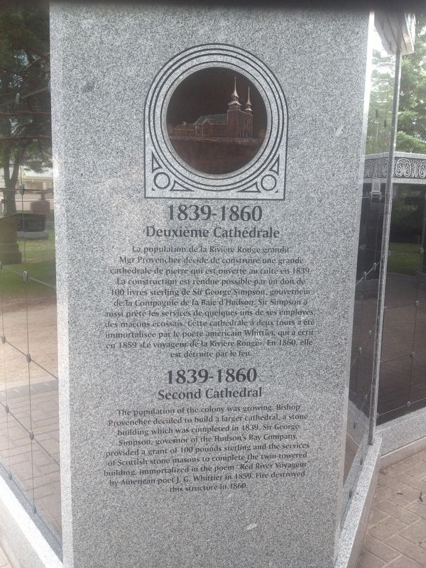
The Second Cathedral Marker
| On Tache Avenue, 0.1 kilometers south of Avenue de la Cathedrale, on the right when traveling north. |
| Near Main Street (Trans-Canada Highway) (Provincial Highway 1) just south of Broadway, on the right when traveling south. |
| Near Assiniboine Avenue at Garry Street, on the right when traveling east. |
| On Broadway (Trans-Canada Highway) (Provincial Highway 1) just west of Donald Street, on the left when traveling west. |
| Near Main Street (Trans-Canada Highway) (Provincial Highway 1) just south of Broadway, on the right when traveling south. |
| On Kennedy Street, 0.2 kilometers south of Broadway (Trans-Canada Highway) (Provincial Highway 1), on the right when traveling south. |
| Near Assiniboine Avenue just west of Main Street (Trans-Canada Highway) (Provincial Highway 1), on the left when traveling west. |
| Near Broadway (Trans-Canada Highway) (Provincial Highway 1) just east of Garry Street, on the right when traveling east. |
| Near Broadway (Trans-Canada Highway) (Provincial Highway 1) just east of Garry Street, on the right when traveling east. |
| Near Main Street (Trans-Canada Highway) (Provincial Highway 1) just south of Broadway, on the right when traveling south. |
| On Qu'Appelle Avenue at Edmonton Street, on the left when traveling east on Qu'Appelle Avenue. |
| On Avenue de la Cathedrale just east of Tache Avenue, on the right when traveling east. |
| Near Avenue de la Cathedrale just east of Tache Avenue, on the right when traveling east. |
| Near Tache Avenue just north of Rue Despins, on the right when traveling north. |
| Near Tache Avenue just north of Rue Despins, on the right when traveling north. |
| Near Tache Avenue just north of Rue Despins, on the right when traveling north. |
| On King Street (Manitoba Route 42) just north of William Avenue, on the right when traveling north. |
| On King Street (Manitoba Route 42) just north of William Avenue, on the right when traveling north. |
| On Main Street (Manitoba Route 42/52) just north of James Avenue (Manitoba Route 42), on the right when traveling north. |
| On King Street (Manitoba Route 42) just north of William Avenue, on the right when traveling north. |
| On Balmoral Street just north of Portage Avenue, on the left when traveling north. |
| On Memorial Boulevard (Provincial Highway 62) just south of Portage Avenue (Provincial Highway 85), on the right when traveling south. |
| On Carlton Street (Manitoba Route 57) just south of Ellice Avenue, on the right when traveling south. |
| On Graham Avenue just east of Edmonton Street, on the right when traveling east. |
| On Main Street (Manitoba Route 52) at McDermot Avenue, on the right when traveling north on Main Street. |
| On Main Street (Manitoba Route 52) at Market Avenue, on the right when traveling north on Main Street. |
| On Market Avenue at Rorie Street, on the right when traveling east on Market Avenue. |
| On Main Street (Manitoba Route 52) just south of William Avenue, on the right when traveling south. |
| On Main Street (Manitoba Route 52) just south of Bannatyne Avenue, on the right when traveling south. |
| On Princess Street just south of Elgin Avenue, on the right when traveling south. |
| On Princess Street just south of Coulter Avenue, on the right when traveling south. |
| On William Avenue at Main Street (Provincial Route 52), on the right when traveling east on William Avenue. |
| On King Street (Manitoba Route 42) at Bannatyne Avenue, on the right when traveling north on King Street. |
| On Main Street (Manitoba Route 52) just north of Bannatyne Avenue, on the right when traveling north. |
| On Lombard Avenue just east of Main Street (Provincial Route 52), on the right when traveling west. |
| On Market Avenue just east of Main Street (Provincial Route 52), on the right when traveling east. |
| On John Hirsch Place at Rorie Street, on the left when traveling east on John Hirsch Place. |
| On Main Street (Manitoba Route 52) just south of McDermot Avenue, on the right when traveling south. |
| On Bannatyne Avenue just east of Main Street (Provincial Route 52), on the right when traveling west. |
| On Main Street (Manitoba Route 52) just south of Market Avenue, on the right when traveling north. |
| On King Street (Manitoba Route 42) just south of William Avenue, on the right when traveling north. |
| On Lombard Avenue just west of Rorie Street, on the right when traveling west. |
| On Market Avenue at Lily Street, on the right when traveling east on Market Avenue. |
| On King Street (Manitoba Route 42) just north of Bannatyne Avenue, on the left when traveling north. |
| On Main Street (Manitoba Route 52) just south of William Avenue, on the right when traveling south. |
| On Main Street (Manitoba Route 52) just south of William Avenue, on the right when traveling south. |
| On Main Street (Manitoba Route 52) at Lombard Avenue, on the right when traveling north on Main Street. |
| On Main Street (Manitoba Route 52) just south of William Avenue, on the right when traveling south. |
| On Arthur Street at McDermot Avenue, on the right when traveling south on Arthur Street. |
| Near Assiniboine Avenue, 0.2 kilometers east of Osborne Street North (Provincial Highway 62), on the right when traveling east. |
| On Broadway (Trans-Canada Highway) (Provincial Highway 1) just west of Memorial Boulevard, on the right when traveling west. |
| Near Assiniboine Avenue, 0.2 kilometers east of Osborne Street North (Provincial Highway 62), on the right when traveling east. |
| On Kennedy Street at Broadway (Trans-Canada Highway) (Provincial Highway 1), on the right when traveling south on Kennedy Street. |
| Near Tache Avenue just north of Provencher Boulevard, on the left when traveling north. |
| On Provencher Boulevard (Manitoba Route 57) at Rue Aulneau, on the right when traveling west on Provencher Boulevard. |
| On Ellice Avenue just east of 335 Donald Street, on the left when traveling west. |
| Near Colony Street (Provincial Highway 62) just south of Webb Place, on the right when traveling north. |
| On Main Street (Manitoba Route 52) at Pioneer Avenue, on the right when traveling north on Main Street. |
| On Donald Street just south of Portage Avenue (Provincial Route 85), on the right when traveling south. |
| On Donald Street just north of Graham Avenue, on the left when traveling south. |
| On Main Street (Manitoba Route 52) just south of William Stephenson Way (Manitoba Route 57), on the right when traveling north. |
| On Graham Avenue just east of Donald Street, on the right when traveling east. |
| On Graham Avenue just east of Donald Street, on the right when traveling east. |
| Near Forks Market Road, 0.3 kilometers east of Fort Gibraltar Trail. |
| Near Chancellors Circle, 0.2 kilometers north of Dafoe Road West. |
| On University Crescent at Dysart Road, on the right when traveling south on University Crescent. |
| Near Chancellors Circle, 0.2 kilometers north of Dafoe Road West. |
| Near Chancellors Circle, 0.2 kilometers north of Dafoe Road West. |
| Near Chancellors Circle, 0.2 kilometers north of Dafoe Road West. |
| Near Chancellors Circle, 0.2 kilometers north of Dafoe Road West. |