808 entries match your criteria. Entries 201 through 300 are listed.⊲ Previous 100 — Next 100 ⊳
Native Sons/Daughters of the Golden West Historical Markers
The NSGW was formed by Albert Maver Winn in 1875 to preserve the California historic buildings and sites of the Gold Rush and prior. The only requirement to be a member is to have been born in California. The sister organization, NDGW, followed soon thereafter.
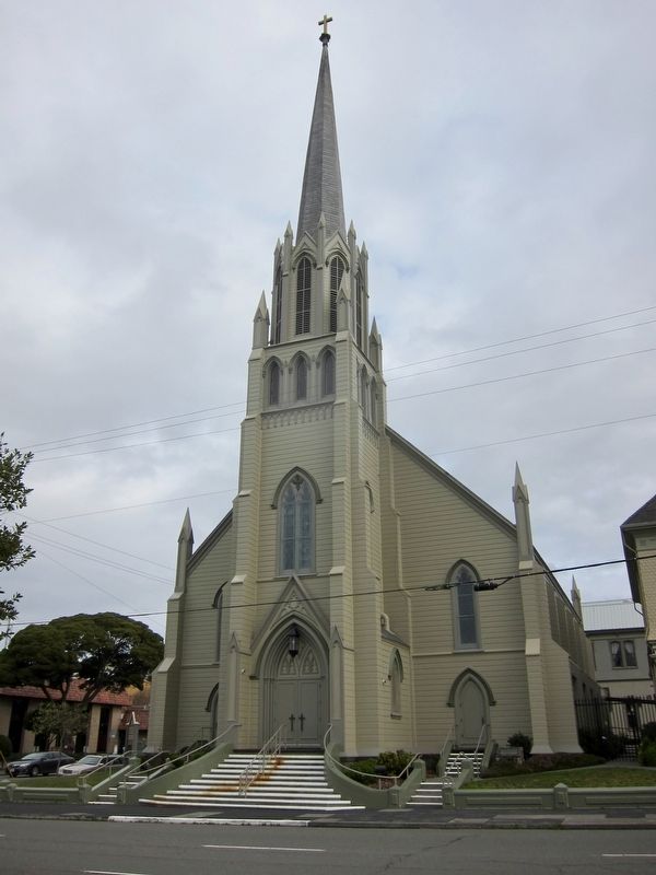
Was consecrated by Bishop Manogue on June 6, 1886 - built by local architect James Simpson under the direction of the pastor, Father John S. Sheridan. It is the second church constructed at this location.
Dedicated by the Grand Parlor . . . — — Map (db m108024) HM
This home, also known as the “Pink Lady,” is a classic Queen Anne/Eastlake Victorian residence designed by the prestigious architectural firm of Newsom Brothers of San Francisco. It was completed in 1889 for William Carson, a pioneer lumber baron . . . — — Map (db m1498) HM
The six Victorian era houses “905-935” Third Steet were developed by Samuel McFarland from 1884 to 1904. Mr. McFarland came to Humboldt County from New Brunswick, Canada in 1866 at the invitation of his brother-in-law, William Carson . . . — — Map (db m71972) HM
The Hotel Vance was built in 1872 by Eureka pioneer & lumberman,
John Vance. It was the area's grandest hotel & the first building in
Eureka with electricity. It was originally designed & built in the
"Modern Italianate style”, which . . . — — Map (db m135459) HM
This was the first building expressly constructed for the Eureka Post
Office Postmaster Frederick Aze, (served as Eureka postmaster for 17
years.) motivated by cramped and ill suited facilities at 612
Second St. had this building constructed at . . . — — Map (db m135482) HM
Dedicated on November 16, 1911 and affectionately known as the "Queen of Bridges", it was the longest reinforced concrete arch structure in the world at the time of its construction. The bridge was designed by John B. Leonard, Civil Engineer, . . . — — Map (db m71907) HM
Erected in the early 1870s, this magnificent structure was a drug store. In 1877 it became known as the Alford Drug Store until 1886. In 1879, Wells Fargo and Co. established an express station in the Alford Drug Store and maintained it through . . . — — Map (db m71959) HM
In 1876 John Gardner Kenyon surveyed and laid out this once flourishing southern Humboldt port. The original townsite encompassed 60 acres, subdivided by streets 60 to 80 feet wide. Shipping and other commercial ventures increased steadily from 1878 . . . — — Map (db m176156) HM
The 780 prisms and fresnel lenses in this replica of the original Cape Mendocino Light House were hand ground in France, shipped around Cape Horn and originally placed in operation at Cape Mendocino in 1868. The entire mechanical gear and prisms . . . — — Map (db m189002) HM
The Ferndale Cemetery Association was organized and incorporated in 1868. This 5 acre tract of land was purchased in 1870 from Francis and Grace Francis for $155.00, as its
steep slopes made it unsuitable for farm land. The first
burials were . . . — — Map (db m142811) HM
Ferndale Meat Market was already in operation at the time of the fire of 1875 and was lost in the fire of April 1881. It was rebuilt at its present location and back in operation by mid May of that same year. Joseph Russ’ involvement in the business . . . — — Map (db m71955) HM
The Memorial Day Parade, previously known as the Decoration Day Parade, in Ferndale began in 1882, when the participants were mainly Civil War Veterans who organized themselves as the Grand Army of the Republic. In the early 1900s, the Native Sons . . . — — Map (db m231396) HM
Circa 1890. Furthest westernly bar in the continental United States.
Dedicated February 13, 1993 by the Native Sons of the Golden West. Harley M. Harty, Grand President
In memory of Joseph G. Oeschger PGP — — Map (db m65266) HM
Also known as the Roberts Hotel, Ferndale Hotel, and the Italian-Swiss Hotel, it was the first and is the last of the original hostelries in Ferndale. Originally built in 1870, burnt to the ground and rebuilt in 1875, then remodeled in the late . . . — — Map (db m71958) HM
Dedicated to Joseph Carl Oeschger in Recognition of his contribution to sports and to the youth who participate.
An all around athlete who began his career in Ferndale, he went on to professional baseball where he distinguished himself as a . . . — — Map (db m246032) HM
Built in 1922, and constructed mainly of old growth redwood by volunteers of the Ferndale Community. Fire destroyed the kitchen in 1963. Rebuilt in 1990-1993 through contributions and community efforts. It has served our community well throughout . . . — — Map (db m65190) HM
Originally constructed as a warehouse in July of 1902; known as the A. Berding Warehouse and housed many businesses. In 1919 Hampton C. Blum acquired the warehouse. In January 1929, The Danish Hall Committee started considerations for pu(r)chase. . . . — — Map (db m71939) HM
This site, originally R.A. Simpson's Ferndale Mechanical Shop, and shared by A. Monroe Cider and Vinegar Company, was chosen in 1904 by Aage Jensen as the founding location of the Central Creamery with first production of butter in September, . . . — — Map (db m65235) HM
Built in 1898 this building is of the East Lake Stick-Style tradition, a fine example of Victorian Architecture. The tapered oriel windows that project from the upper story are Italianate in shape with the overall design being very much English. . . . — — Map (db m71953) HM
Pioneer Seth Louis Shaw began construction of his home, Fern Dale, in 1854.
The town was named after his first permanent home.
The home, in its original condition, is a fine
example of Gothic architecture.
The house is a landmark
and a source . . . — — Map (db m220451) HM
The Victorian Inn was built in 1890 with completion in 1891, and known as the Russ Building. The structure was originally built to house the Ferndale Bank with the Ferndale Enterprise Newspaper following. There were 33 rooms on the second floor; . . . — — Map (db m65289) HM
Built in the late 1870's or early 1880's, the Fields Landing Hotel originally was used house rail train passengers bound for Eureka. They then continued on by boat to Eureka. In 1913 the railroad was extended to Eureka. The Fields Landing Hotel was . . . — — Map (db m108026) HM
The first Fortuna Rodeo was held on August 27 & 28, 1921 in the newly created Rohner Park, and was sponsored by the Humboldt County Stockman’s Association. At this time the rodeo was a pro-am event and saw such talent as Jesse Stahl, Clay Carr, . . . — — Map (db m219693) HM
This is the last lumber camp style cookhouse in operation in North America. This cookhouse was originally opened as part of Samoa, one of the last company owned towns in the United States, established by the Vance Lumber Company. The original . . . — — Map (db m65422) HM
The Scotia Museum is a textbook example of Greek Revival architecture. The natural redwood trunks used for classical columns have an unmistakeable association with the timber industry.
The two-story structure has a low-pitched shingle roof, a . . . — — Map (db m61055) HM
Their first sawmill was built in 1887 at their current location and employed 150 men to turn the giant redwoods into shingles and other products.
Originally named Forestville, the town name was changed to Scotia in 1888. Scotia is one of the last . . . — — Map (db m71988) HM
The Wi'ne'ma Theatre was built in 1919 and named for a young
Indian girl who devoted her life to establishing friendly relations
between her people, the Modoc Indians, and the white men. The
first performance was on November 20, 1920 and tells . . . — — Map (db m142815) HM
At this historic spot the first irrigation water from the Colorado River reached Imperial Valley in 1901, coming from Mexico. This waterway was replaced in 1942 by the All-American Canal. Water has made this once arid area into an agricultural . . . — — Map (db m176186) HM
The Imperial Valley Press was established in 1901 with the aid of W.F. Holt in the town of Imperial and was known as the Imperial Press. Mr. Holt moved the paper to the new city of El Centro in 1906 and changed the name to the Imperial Valley Press. . . . — — Map (db m105982) HM
In 1908 Hardy McConnell and son, Leslie, (A Native Son) left Temescal Canyon, near Corona, enroute to settle in Imperial Valley, driving two teams of horses pulling wagons, hauling farm implements, chickens and leading a cow.
Fourteen days later . . . — — Map (db m81635) HM
Established and organized in 1908 as the Men Club to promote the city of El Centro, their first goal was for El Centro to reach a population of 10,000 residents. On October 30, 1908 the women took over the club and renamed it the Women's 10,000 . . . — — Map (db m101569) HM
Harold Bell Wright rose from poverty to become "America's favorite author" for the first three decades of the 20th Century.
Many of his 19 books were best sellers and made into both "silent" and later "talkies". They include '"The Winning of . . . — — Map (db m62033) HM
E Clampus Vitus marker dedicated 1983
Holtville
W. F. Holt established this townsite in 1903; built the first electric power plant at 3rd and Holt, the Holton Interurban RR; started the first church, the first newspaper and donated . . . — — Map (db m62031) HM
The church was organized January 14, 1911. The building was constructed the same year on one-half acre of land given by W.J. Seat, located one-quarter mile south of this site. The founders saw Imperial Valley as a land of opportunity for their . . . — — Map (db m153393) HM
Emil Schaffner arrived from Rufenach, Switzerland, through Ellis Island, in 1914, bound for Imperial Valley. He began working in Calexico for Judge Towland, insisting on being paid in cattle. In 1921, Emil established "Schaffner Dairy" and it has . . . — — Map (db m219773) HM
The largest gravity fed irrigation district in the western hemisphere, established in 1911. They later assumed control of several water companies and were instrumental in getting the Hoover Dam and the All American Canal built.
They commenced . . . — — Map (db m62035) HM
This highway parallels the old Indian trail, still visible from here, connecting the Imperial and Palo Verde Valleys.
The grateful people of Imperial County honor the memory of our beloved Senator Ben Hulse, who worked untiringly for the people . . . — — Map (db m57702) HM
Padre Garcés, first recorded non-Indian to visit this locality, came in April of 1776, seeking a new route from Mexico to California. His epic journey covered more than two thousand miles of uncharted wilderness, opening trails that later became . . . — — Map (db m11932) HM
Colonel Thomas Baker, Civil Engineer – Lawyer — Farmer – Soldier, 1810 – 1872.
In 1863 Colonel Baker came to this location. A friend to all travelers, his settlement became known at “Baker’s Field.” This civic center is his dream come true. . . . — — Map (db m134436) HM
Oil was discovered at 70 feet in 1899, when Tom Means persuaded Roe Elwood and Frank Wiseman, aided by Jonathan, Bert, Jed, and Ken Elwood, George Wiseman, and John Marlowe, to dig here for oil. On June 1, 1899, 400 feet to the north, Horace and . . . — — Map (db m168102) HM
Gordon’s Ferry was an overhead cable type of ferry operated during the 1850’s by Major Gordon. An adobe station house was located on the south bank of Kern River, just a few yards to the west of this marker. It was also a station on the Butterfield . . . — — Map (db m25149) HM
Near this spot stood the last home of Elisha Stevens, noted American pathfinder and scout. Born in Georgia April 5, 1804, he learned blacksmithing during his youth. Drifting west he became a trapper on the Upper Missouri for more than two decades. . . . — — Map (db m231869) HM
Just south of this point stood the Butterfield Overland Stage site known as Kern River Slough. Operating through present Kern County during 1858 – 1861. This famous line ran from St. Louis, Missouri to San Francisco until the outbreak of the . . . — — Map (db m24946) HM
Near this site stood the home of Alexis Godey, frontiersman and scout, who lived here from 1883 until his death on January 19, 1889. Born in St. Louis, Missouri in 1818, he acted as guide for John C. Frémont's expedition through the Kern area in . . . — — Map (db m51676) HM
One-room school houses dotted the rural Western landscape to serve sparse populations before the automobile made transportation to towns faster and easier.
This one-room school was built in 1882 north of the town of Rosedale on land . . . — — Map (db m25075) HM
Two and one half miles east of this point, on a small flat south of Poso Creek, is the site of one of six stagecoach stations in Kern County belonging to the Butterfield Overland Mail Company. The Butterfield Company operated along a southern route . . . — — Map (db m168620) HM
One mile north of here on May 1, 1776, Francisco Garces of the Franciscan Order, crossed Kern River in his search for a shorter route from Sonora, Mexico to Monterey, California. He was the first known explorer to describe this river, which he . . . — — Map (db m24984) HM
Named for Edward F. Beale, this station on the Southern Pacific rail line was established in 1876 as a depot and telegraph office. Service was discontinued in 1943. Beale was Superintendent of California Indian Affairs during the 1850’s. In 1865 he . . . — — Map (db m119218) HM
Originally known as Allen's Camp after Gabriel Allen, who in the 1870s had a cabin and stock pasture near here, the settlement was named Caliente when railroad construction reached this point in April 1875. The town became a railroad terminal for . . . — — Map (db m157683) HM
Kern County’s oldest residence. Built before Civil War by Thomas Fitzgerald as trading post at junction of two Indian trails. Present Greenhorn Road follows east – west trail (later McFarlane Toll Road) to Kern River mining districts. Town named . . . — — Map (db m25032) HM
In 1854 John C. Reid filed a squatter’s claim on this spot. This same year Kern County’s first school class was held here. In 1859 David Lavers, with his father and brother, John, built a hotel and stage barn on the Old Bull Road. The crossing was . . . — — Map (db m25323) HM
Wm. B. Rose, in 1875, a mile east; built an adobe stage station on the site of the Overland Mail Way Station established 1858. From 1853 to 1875 site was known as Rancho Canoa (trough). Originally vaquero camp of the Sebastian Indian Reservation. . . . — — Map (db m20196) HM
The Sebastian or Tejon Indian Reservation (headquarters 10 miles east of here) was established in 1853 by Gen. Edward Fitzgerald Beale as one of several California Reservations. The number of Indians quartered here varied from 500 to 2000. General . . . — — Map (db m108915) HM
Gold deposits at Havilah were discovered in 1864. Havilah was the county seat between 1866, when Kern County was organized, and 1872, when the government was moved to Bakersfield. Havilah was an active mining center for more than 20 years, and . . . — — Map (db m51821) HM
Near this spot at the confluence of the north and south forks of the Kern River the Theodore Talbot Party of Captain John C. Fremont’s third expedition to the West camped for several weeks during December 1845 and January 1846. The river was named . . . — — Map (db m25092) HM
From 1853 until 1870 Keyesville was a center of both placer and quartz gold mining. On the knoll just below the townsite may still be seen the outlines of an earth-work fort, built to meet a possible Indian attack in 1863. The original Keys Mine is . . . — — Map (db m143331) HM
In 1772, Don Pedro Fages, leaving the first written record of explorations in the south San Joaquin Valley, passed this site, traveling from San Diego to San Luis Obispo via Cajón Pass, Mojave Desert, Hughes Lake, Antelope Valley, Tejón Pass, . . . — — Map (db m20132) HM
This military post was established by the United States Army on June 24, 1854, to suppress stock rustling and for the protection of Indians in the San Joaquin Valley. As regimental headquarters of the First Dragoons, Fort Tejón was an important . . . — — Map (db m117523) HM
Although little is known about Peter Lebec, it is believed that he was killed by a grizzly bear, and buried under this tree. His epitaph was originally carved into the tree. — — Map (db m11092) HM
America's most spectacular gusher blew in here on March 14, 1910. Initially 18,000 barrels per day, the flow later reached an uncontrolled peak of 100,000 barrels per day, completely destroying the derrick. This Union Oil Company well produced nine . . . — — Map (db m54267) HM
Eight miles due west of this marker stood one of California's first commercial oil refineries. Between August 1864 and April 1867, approximately 4,000 gallons of illuminating oil produced there was shipped to San Francisco by the Buena Vista . . . — — Map (db m78295) HM
Located one-eighth mile west of here is an
ancient asphaltum seepage in which hundreds
of Pleistocene Age (15,000-50,000 years ago)
birds, insects, and animals were trapped.
The skeletal remains found in the pit include
giant condors, giant . . . — — Map (db m168958) HM
In 1772, Don Pedro Fages, first recorded non-Indian to visit the southern San Joaquin Valley, crossed this spot on his way from San Diego to San Luis Obispo. Near this point crossed Father José María de Zalvidea in 1806, while accompanying the Ruiz . . . — — Map (db m54266) HM
Six miles east of this point was the site of the Butterfield Stage Line station Sinks of Tejón. Operating through present Kern County during 1858-61, this famous line ran from St. Louis, Missouri to San Francisco until the outbreak of the Civil War. — — Map (db m144943) HM
Just west of this point was the Southern Pacific terminus for the Twenty-Mule-Team Borax wagons that operated between Death Valley and Mojave from 1884 to 1889. The route ran from the Harmony Borax Mining Company works, later acquired by the . . . — — Map (db m123891) HM
Discovered by Joseph R. Walker, American trail-blazer who left the San Joaquin Valley through this pass in 1834. This area was traversed by topographer Edward M. Kern, after whom the Kern River was named, while accompanying the Fremont expedition of . . . — — Map (db m159834) HM
In 1896 Eugene Garlock constructed a stamp mill near this spot for the crushing of gold ore from the Yellow Aster Mine on Rand Mountain. Known originally as Cow Wells, by prospectors and freighters during the 1880’s and early 1890’s, the town of . . . — — Map (db m51672) HM
The Yellow Aster, or Rand Mine, was discovered in April, 1895 by Singleton Burcham and Mooers. The town of Randsburg quickly developed followed by the supply town of Johannesburg in 1896. Both names were adopted from the profusion of minerals . . . — — Map (db m50461) HM
Willow Springs was a stage station on the Los Angeles-Havilah Stage Lines, 1864-1874. From here light traffic went through Oak Creek Pass via Tehachapi to Havilah and Kernville; heavy traffic went northwest to the Inyo mines, or via Jawbone Canyon . . . — — Map (db m156685) HM
Constructed on the basic plan of Sutter’s original fort one hundred years after its erection in Sacramento by that distinguished pioneer Captain John Augustus Sutter. The building of this replica of one of the most outstanding landmarks to the early . . . — — Map (db m130655) HM
The old Yokuts village of Tulamniu was named Buena Vista by Spanish Commander Fages in 1772. (One of first place names in south San Joaquin Valley.) Fr. Zalvidea again recorded the site in 1806. This village was occupied for several centuries. . . . — — Map (db m130232) HM
The oldest settlement in Tehachapi Valley, known as 'Old Town,' was established here during the 1860s. It was long an important station on the road between Southern California and the San Joaquin Valley. The community began to decline when residents . . . — — Map (db m139964) HM
Father Francisco Garces used the Oak Creek Pass in 1776 to return to the Mojave after exploring the San Joaquin Valley, as did Fremont in 1844-45. Until the building of the railroad through the Tehachapi Pass in 1876, Oak Creek Pass was the only . . . — — Map (db m50250) HM
From this spot may be seen a portion of the world-renowned “Loop.” It was completed in 1876 under the direction of William Hood, Southern Pacific Railroad Engineer. In gaining elevation around central hill of loop a 4000 foot train will cross 77 . . . — — Map (db m134430) HM
In the Kawaiisu language, tomo-kahni means winter village. The site's location between the coast and desert allowed the site occupants to hold an important place for trade between these areas and the southern Central Valley. The sacred rock art . . . — — Map (db m92889) HM
On May 3, 1776, three miles north of this point at a Yokut village site in Grizzly Gulch, father Francisco Garcés performed the first recorded baptism in the San Joaquin Valley. The service was held for a dying Yokut boy he called Muchachito (young . . . — — Map (db m168621) HM
One and one-half miles north of this point stood the Mountain House Station on the route of the Butterfield Stage. Operating through present Kern County during 1858-1861, this famous line ran from St. Louis, Missouri to San Francisco until the . . . — — Map (db m168616) HM
Scene of a battle between U.S. soldiers under command of Captain Lyons and Indians under Chief Augustine, April 14th, 1850.
Dedicated as an historical monument by the Native Sons of the Golden West
May 20th, 1942 — — Map (db m1055) HM WM
In memory of
An Unknown Soldier
who was buried here about 1870 on this the Old Military Road which ran from Ft. Bidwell in Modoc Co. to Ft. Crook, Shasta Co. — — Map (db m87821) HM
Built in July 1854 by Isaac N. Roop. First called Roop's House, and used as stopping place by emigrant trains. It was the locale of the "sagebrush war" fought in 1863 between Plumas County and Lassen County citizens. — — Map (db m10266) HM
Constructed and dedicated to honor
the Veterans of World War I
and all future Veterans who have served the
United States of America and Lassen County,
Constructed February through August of 1926 and
Dedicated on August 17, 1926
The . . . — — Map (db m113271) HM WM
The first adobe schoolhouse in 1869 was located near Ravenna, and served the children of miners and ranchers covering a 2,500 square mile area. A subsequent structure, built in 1870, was destroyed by flood in 1880. The present brick schoolhouse, . . . — — Map (db m145704) HM
Contained within this building are the remaining portions of an adobe house built by Francisco Salvador Lugo and his son Antonio María Lugo. Francisco Lugo was a prominent early landholder and Antonio served as the Alcalde of Los Angeles. They . . . — — Map (db m125567) HM
[The arch way leading to the grounds is flanked by two markers:]
Right Marker:
Domínguez Ranch House
Central portion built in 1826 by Manuel Domínguez.
Rancho San Pedro
Ten square leagues granted, . . . — — Map (db m64857) HM
The original house of two rooms was built in 1869 by A.R. Loomis. Other rooms were added by successive occupants. It was marked as the "Oldest House in Compton" in 1955; purchased by the city June 11, 1957; and removed from 209 South Acacia Street . . . — — Map (db m50977) HM
The firehouse-jail was the first civic building
commissioned by the city of Covina. The mission
revival structure was constructed in 1911 by pioneer builder Clarence Allison. When a new city hall and fire station was built in 1930, the fire . . . — — Map (db m138043) HM
San Rafael Rancho, first granted to José Maria Verdugo, Oct. 20, 1784.
Catalina Adobe built about 1828.
And, General Andres Pico oak tree camp site, before he surrendered to General John C. Fremont, 1847. — — Map (db m128201) HM WM
This was the first National Forest in the State of California, second in the United States. Created by proclamation, December 20, 1892, by President Benjamin Harrison. The first name given to the forest was "San Gabriel Timberland Reserve." It was . . . — — Map (db m143501) HM
This house, built in 1868 by Saturnio Carrion, was restored in 1951 by Paul E. Traweek.
California Registered Historical Landmark No. 386. — — Map (db m127951) HM
This buiding, erected by the Gilroy family in 1876, this building was purchased in 1902 by George T. Webber, who operated it as the Western Hotel. The Lancaster Chamber of Commerce was organized in its dining room. Between 1905 and 1913, . . . — — Map (db m53028) HM
[Upper Marker - as seen in 2001] This monument marks the intersection of three original California Ranchos:
Rancho Los Alamitos
Rancho Los Cerritos
Rancho Los Coyotes
[Lower Marker - as seen in 2002]
Ranchos
Los Alamitos . . . — — Map (db m50231) HM
Long Beach citizens built at this location the first publicly owned high school structure in Los Angeles County outside Los Angeles City. The Board of Trustees met here in April of 1893, dedicated the building in May, and opened it to pupils in . . . — — Map (db m72449) HM
William Erwin Willmore who was in this area in 1870 visualized a town would be built here. In 1882 this materialized as Willmore City; becoming the City of Long Beach in 1888. — — Map (db m83523) HM
808 entries matched your criteria. Entries 201 through 300 are listed above. ⊲ Previous 100 — Next 100 ⊳