March 8, 2010
Lieutenant George A. Woodruff Marker
| On Homer Road, on the right when traveling south. |
| On Verona Road at 14 Mile Road, on the right when traveling west on Verona Road. |
| On Michigan Avenue (Business Interstate 94), on the right when traveling east. |
| On West Prospect Street, on the right when traveling west. |
| On Michigan Avenue at South Parkview, on the right when traveling east on Michigan Avenue. |
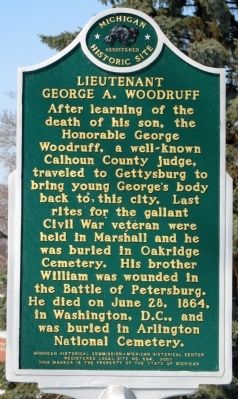
| On South Marshall Avenue at East Green Street, on the right when traveling north on South Marshall Avenue. |
| On West Michigan Avenue, 0.1 miles east of South Eagle Street, on the right when traveling east. |
| On West Mansion Street at North Eagle Street, on the right when traveling west on West Mansion Street. |
| On West Hanover Street at South Linden Street, on the right when traveling east on West Hanover Street. |
| On West Mansion Street at North Eagle Street, on the left when traveling west on West Mansion Street. |
| On Homer Road at Willow Street, on the left when traveling east on Homer Road. |
| On West Hanover Street, 0.1 miles west of South Sycamore Street, on the right when traveling east. |
| On South Eagle Street at West Green Street, on the right when traveling north on South Eagle Street. |
| On Exchange Street at East Green Street, on the right when traveling south on Exchange Street. |
| On Sixteen Mile Road, 0.5 miles south of N-Drive North, on the right when traveling north. |
| On 15 1/2 Mile Road at N-Drive North, on the right when traveling south on 15 1/2 Mile Road. |
| On Michigan Avenue, 0.1 miles west of North Grand Street, on the right when traveling east. |
| On West Michigan Avenue at South Park Avenue, on the right when traveling east on West Michigan Avenue. |
| On Michigan Avenue at North Grand Street, on the right when traveling west on Michigan Avenue. |
| On North Madison Street at East Michigan Avenue, on the right when traveling south on North Madison Street. |
| On East Mansion Street at North Jefferson Street, on the right when traveling west on East Mansion Street. |
| On West Michigan Avenue, 0.1 miles east of South Eagle Street, on the right when traveling east. |
| On 603 North Kalamazoo Avenue, 0.1 miles north of Hobalt Road, on the right when traveling south. |
| On North Shore Drive at U Drive North on North Shore Drive. |
| On East North Street at North Main Street, on the right when traveling west on East North Street. |
| On East Canal Street at North Walnut Street, on the right when traveling west on East Canal Street. |
| On North Broadway Street (State Highway 62) at East State Street (State Highway 60), on the right when traveling north on North Broadway Street. |
| On Chain Lake Street, 0.6 miles east of Carver Road, on the right when traveling east. |
| On Marcellus Highway, 0.2 miles east of Decatur Rd, on the right when traveling east. |
| On Main Street (Michigan Route 62) at North Lowe Street, on the left when traveling west on Main Street. |
| On Middle Crossing Road at Garrett Road, on the right when traveling west on Middle Crossing Road. |
| On School Street at Sink Road, on the right when traveling west on School Street. |
| On Leach Road, 0.2 miles north of Topash Street, on the right when traveling north. |
| On Courtland Street, 0.1 miles west of Center Street, on the right when traveling west. |
| Near U.S. 12 at Kessington Road, on the right when traveling east. |
| Near Redfield Rd, 0.4 miles west of Brush Road, on the right when traveling west. |
| On Lake Street at Church Street, on the right when traveling north on Lake Street. |
| On Born Street at Patterson Hill Road, on the right when traveling west on Born Street. |
| On Vermont Street at Kansas Street, on the left when traveling south on Vermont Street. |
| On Pokagon Highway at Wood Road, on the right when traveling west on Pokagon Highway. |
| On State Street (State Highway 60) at Water Street, on the right when traveling east on State Street. |
| On Green Sky Hill, 0.2 miles east of Old U.S. 31, on the right when traveling south. |
| Near M-66, 0.8 miles north of Lord Road, on the right when traveling north. |
| On Boyne City-Charlevoix Road (County Road 56) east of Lake Street, on the left when traveling east. |
| On South Shore Drive (Michigan Route 75) near State Street and North Shore Drive, on the left when traveling south. |
| On South Huron Street south of Court Street, on the right when traveling south. |
| On Court Street east of South Huron Street, on the right when traveling east. |
| Near State Road, 0.4 miles west of Michigan Highway 68. |
| Near North Nicolet Street at North Huron Avenue, on the right when traveling north. |
| On North Huron Avenue, on the right when traveling east on North Huron Avenue. |
| On South Huron Avenue south of Mackinaw Crossings Drive, on the left when traveling south. |
| Near South Huron Avenue north of Wendell Street, on the right when traveling north. |
| Near North Huron Avenue at North Nicolet Street. |
| Near Old Mackinaw Road, 0.2 miles east of U.S. 23. |
| On Depot Street at East Main Street (County Highway 58), on the right when traveling south on Depot Street. |
| On M-134 (a.k.a.: South Scenic Road) just west of East Lakewood Lane, on the left when traveling west. |
| On State Highway 128 near West South River Road, on the right when traveling north. |
| On North Whitefish Point Road at West Wild Cat Road, on the right when traveling north on North Whitefish Point Road. |
| On North Whitefish Point Road, 0.5 miles north of West North Shore Road. |
| On Michigan Route 123 near North Beaver Road, on the right when traveling north. |
| On East Spruce Street at Bingham Avenue, on the right when traveling west on East Spruce Street. |
| On East Water Street just west of Glenn Avenue, on the right when traveling west. |
| On East Water Street at Bingham Avenue on East Water Street. |
| On East Water Street west of Glenn Avenue, on the right when traveling west. |
| On West Easterday Avenue, 0.1 miles east of Meridian Street, on the right when traveling west. |
| On Riverside Drive, 0.9 miles north of Gardenville Road, on the right when traveling north. |
| On Ryan Avenue at College Drive on Ryan Avenue. |
| On Tuskegee Airmen Memorial Highway (Interstate 75) when traveling north. |
| On East Portage Avenue (U.S. 75 Spur) near Kimball Street, on the right when traveling east. |
| On West 5th Street (State Highway 115) at Beech Street, on the right when traveling west on West 5th Street. |
| On South Clare Avenue, on the left when traveling north. |
| On U.S. 10/127, 0.7 miles north of South Clare Avenue (Business U.S. 127), in the median. |
| On East Clark Road at Wood Road, on the right when traveling west on East Clark Road. |
| On South Grange Road, 0.2 miles south of West Howe Road, on the right when traveling north. |
| Near Interstate 96 at milepost 87,, 1.5 miles east of Wright Road (Michigan Route 100). |
| On West Cirlce Drive, on the right when traveling west. |
| On East Williams Street east of North Main Street, on the left when traveling east. |
| On North Main Street, on the right when traveling north. |
| On Maple Street north of West Cass Street, on the left when traveling north. |
| On Maple Road at G Street, on the right when traveling west on Maple Road. |
| On North Scott Road at West Marshall Road, on the right when traveling south on North Scott Road. |
| On Ingham Street at North James Street (State Highway 72), on the right when traveling east on Ingham Street. |
| On Michigan Avenue at Spruce Street, on the right when traveling north on Michigan Avenue. |
| Near West North Down River Road, 0.2 miles east of South Roberts Road, on the right when traveling east. |
| Near Interstate 75 at milepost 252,, 1.1 miles north of West 4 Mile Road when traveling north. |
| On East County Road 612, on the right when traveling east. |
| On Ogden Avenue south of South 6th Street, on the right when traveling south. |
| On Ludington Street east of South 2nd Street, on the left when traveling east. |
| On Ludington Street east of Third Street, on the right when traveling east. |
| On Ludington Street at Water Plant Road, on the right when traveling north on Ludington Street. |
| On East Ludington Street at Iron Mountain Street, on the right when traveling west on East Ludington Street. |
| Near Kent Street west of Fairbanks Street/Carpenter Avenue, on the left when traveling east. |
| On South Stephenson Avenue (U.S. 2) at East C Street, on the right when traveling north on South Stephenson Avenue. |
| On Blaine Street at Millie Street, on the right when traveling west on Blaine Street. |
| Near North Stephenson Avenue (U.S. 2) 0.2 miles south of Lake Antione Road. |
| On Tanners Alley near East Mill Street, on the right when traveling north. |
| On Cochran Avenue (Business Interstate 69) south of Tirrell Street, on the left when traveling south. |
| On Narrow Lake Road, 0.1 miles east of Brookfield Road, on the left when traveling east. |
1551 entries matched your criteria. Entries 201 through 300 are listed above.
⊲ Previous 100 —
Next 100 ⊳