133 entries match your criteria. The first 100 are listed. ⊳
Historical Markers and War Memorials in Munster
April 9, 2009
Historic Kilfenora / Cill Fhionnúrach Stairiúil Marker
| 1 ► Ireland, Munster, County Clare, Kilfenora — Historic Kilfenora / Cill Fhionnúrach Stairiúil — |
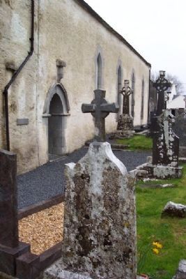
| 2 ► Ireland, Munster, County Clare, Kilfenora — Kilfenora Cathedral and High Crosses — Ardeaglais agus Ardchrosanna Chill Fhionnúrach — |
| 3 ► Ireland, Munster, County Cork, Béal na mBláth — Béal na mBláth Ambush Site — |
| On Local Route L2011, 1 kilometer south of Munster Route R585, on the left when traveling south. | |||
| 4 ► Ireland, Munster, County Cork, Cobh — Bishop Roche Park/ Cove Fort — Páircan Easpaig De Róiste/Dún An Cóibh — Titanic Memorial Garden — |
| Near The Mall. | |||
| 5 ► Ireland, Munster, County Cork, Cobh — Old Church Cemetery — Titanic Trail — Lusitania Victims Mass Graves — |
| Near Hilltop Park at Tay Road. | |||
| 6 ► Ireland, Munster, County Cork, Cobh — S.S. Lusitania — |
| On Strand Road. | |||
| 7 ► Ireland, Munster, County Cork, Cobh — United States Naval Headquarters — Cobh (Queenstown), Co. Cork, 1917-1919 — |
| On Beechmount, 0.1 kilometers east of Thomas Kent Street, on the right when traveling east. | |||
| 8 ► Ireland, Munster, County Cork, Enniskeane — First Meeting of Ból Chumann na hÉireann — (Irish Road Bowling Association) — |
| On Munster Route R588 at Main Street (Munster Route R586), on the left when traveling north on State Route R588. | |||
| 9 ► Ireland, Munster, County Cork, Kilbrittain — Kilbrittain Castle — |
| On Munster Route R603, on the right when traveling north. | |||
| 10 ► Ireland, Munster, County Cork, Kilbrittain — The Book of Lismore — |
| On Munster Route R603, on the right when traveling north. | |||
| 11 ► Ireland, Munster, County Cork, Kilgarvan — Annie Moore Statue — |
| On Lower Road. | |||
| 12 ► Ireland, Munster, County Cork, Killumney — Bride Park Cottage — Birthplace of Major General Patrick Ronayne Cleburne — |
| On Grange Terrace. | |||
| 13 ► Ireland, Munster, County Cork, Kinsale — 4 — Caisleán Deasúnaigh / Desmond Castle — Ceann t-Sáile Baile Stairiúil / Kinsale Historic Town — |
| On Cork Street at Chairmans Lane, on the left when traveling north on Cork Street. | |||
| 14 ► Ireland, Munster, County Cork, Kinsale — 5 — Eaglais Eoin Naofa / St. Johns Parish Church — Ceann t-Sáile Baile Stairiúil / Kinsale Historic Town — |
| On Friar Street just west of Cork Street, on the right when traveling west. | |||
| 15 ► Ireland, Munster, County Cork, Kinsale — 6 — Múseum / Museum — Ceann t-Sáile Baile Stairiúil / Kinsale Historic Town — |
| On Market Lane, on the right when traveling north. | |||
| 16 ► Ireland, Munster, County Cork, Kinsale — Blue Haven Old Fish Market Wall Restoration — |
| On Pearse Street (Munster Route R605) at Market Lane/The Glen, on the right when traveling north on Pearse Street. | |||
| 17 ► Ireland, Munster, County Cork, Kinsale — 12 — Crann Seoil / 1601 Galleon Mast — |
| On Pier Road (Munster Route R600) 0.3 kilometers south of Emmet Place, on the left when traveling south. | |||
| 18 ► Ireland, Munster, County Cork, Kinsale — 16 — Dún Cathal / Charles Fort — |
| On Cork Street (Munster Route R600) at Market Lane, on the left when traveling south on Cork Street. | |||
| 19 ► Ireland, Munster, County Cork, Kinsale — 15 — Dún Shéamais / James Fort — |
| On Pier Road (Munster Route R600) just south of Emmet Place, on the right when traveling north. | |||
| 20 ► Ireland, Munster, County Cork, Kinsale — 1 — Eaglais Multose Naofa / St. Multose Church — |
| On Church Square just west of Cork Street, on the right when traveling west. | |||
| 21 ► Ireland, Munster, County Cork, Kinsale — Fish Shed / Bothán na nÉisc — |
| On Pier Road (Munster Route R600) at Emmet Place, on the right when traveling south on Pier Road. | |||
| 22 ► Ireland, Munster, County Cork, Kinsale — Kinsale — With the Villages of Cove and Scilly — 1846 — |
| On Market Square at Guardwell, on the right when traveling east on Market Square. | |||
| 23 ► Ireland, Munster, County Cork, Kinsale — Kinsale - A Walled Town — |
| On Market Lane at Milk Market, on the right when traveling west on Market Lane. | |||
| 24 ► Ireland, Munster, County Cork, Kinsale — Kinsale Town Wall — Kinsale Tidy Towns 2014 — 3 Year 1601 Wall Town Project — |
| On Market Street at Milk Market, on the right when traveling west on Market Street. | |||
| 25 ► Ireland, Munster, County Cork, Kinsale — Kinsale-Cionn TSáile and Antibes-Juan Les Pins Twinning — |
| On The Glen (Munster Route R605) just north of Market Lane/Pearse Street, on the left when traveling north. | |||
| 26 ► Ireland, Munster, County Cork, Kinsale — Lost Seafarers Memorial — |
| On Pier Road (Munster Route R600) 0.3 kilometers south of Emmet Place, on the left when traveling south. | |||
| 27 ► Ireland, Munster, County Cork, Kinsale — Lt Michael P Murphy — |
| On Pearse Street (Munster Route R605) at Market Lane/The Glen, on the left when traveling north on Pearse Street. | |||
| 28 ► Ireland, Munster, County Cork, Kinsale — Nautical Artefacts at Kinsale Museum — |
| On Market Lane, on the left when traveling east. | |||
| 29 ► Ireland, Munster, County Cork, Kinsale — Peter Barry — |
| On Market Lane, on the right when traveling north. | |||
| 30 ► Ireland, Munster, County Cork, Kinsale — Seafarers Memorial — |
| On Pier Road (Munster Route R600) 0.3 kilometers south of Emmet Place, on the left when traveling south. | |||
| 31 ► Ireland, Munster, County Cork, Kinsale — The History of The Tumble Cart — |
| On Market Lane at Milk Market, on the right when traveling west on Market Lane. | |||
| 32 ► Ireland, Munster, County Cork, Kinsale — The James O'Neill Memorial Building — |
| On Church Street just west of Cork Street, on the right when traveling west. | |||
| 33 ► Ireland, Munster, County Cork, Kinsale — The Pauper's Well / Tobar na mbocht — |
| On Church Square just west of Cork Street, on the right when traveling west. | |||
| 34 ► Ireland, Munster, County Cork, Kinsale — The Town Pound — |
| On Market Square at Guardwell, on the right when traveling east on Market Square. | |||
| 35 ► Ireland, Munster, County Cork, Kinsale — The White House — |
| On Pearse Street (Munster Route R605) at Market Lane/The Glen, on the left when traveling north on Pearse Street. | |||
| 36 ► Ireland, Munster, County Cork, Macroom — ~ The Family ~ — Spirit of Macroom — |
| On West Square just south of Castle Street (National Route N22), on the left when traveling south. | |||
| 37 ► Ireland, Munster, County Cork, Macroom — 300th Anniversary of the Granting of Market Rights to Macroom Town — |
| On West Square just south of Castle Street (National Route N22), on the left when traveling south. | |||
| 38 ► Ireland, Munster, County Cork, Macroom — Macroom and the Beautiful Lee Valley — County Cork • Ireland — |
| On West Square just north of South Square, on the left when traveling north. | |||
| 39 ► Ireland, Munster, County Cork, Macroom — Macroom Castle Demesne — |
| 40 ► Ireland, Munster, County Cork, Macroom — United Irishmen 1798 - 1803 — Grateful Remembrance — Ar dheis Dé raibh a n-anamacha. — |
| 41 ► Ireland, Munster, County Cork, Macroom — War Memorial — For God and Country — |
| On Castle Street (National Route N22) at West Square, on the left when traveling west on Castle Street. | |||
| 42 ► Ireland, Munster, County Cork, Old Head — Bina Fitzgerald — |
| On Old Head Ring Route, on the right when traveling south. | |||
| 43 ► Ireland, Munster, County Cork, Old Head — Lusitania Memorial Garden — |
| On Old Head Ring Route, on the right when traveling south. | |||
| 44 ► Ireland, Munster, County Cork, Old Head — Nineteenth Century Ship's Bollard — |
| On Old Head Ring Route, on the right when traveling south. | |||
| 45 ► Ireland, Munster, County Cork, Old Head — Old Head of Kinsale / An Seancheann — |
| On Old Head Ring Route, on the right when traveling south. | |||
| 46 ► Ireland, Munster, County Cork, Old Head — R. M. S. Lusitania — |
| On Old Head Ring Route, on the right when traveling south. | |||
| 47 ► Ireland, Munster, County Cork, Old Head — RMS Lusitania Lifeboat Davit — gifted to The Lusitania Museum at the Old Head — by Gerry Doyle, his wife Josie and their family — |
| On Old Head Ring Route, on the right when traveling south. | |||
| 48 ► Ireland, Munster, County Cork, Old Head — Triangulation Pillar — Grid Reference No W624409 — |
| On Old Head Ring Route, on the right when traveling south. | |||
| 49 ► Ireland, Munster, County Cork, Old Head — Victims of the RMS Lusitania Sinking — |
| On Old Head Ring Route, on the right when traveling south. | |||
| 50 ► Ireland, Munster, County Kerry, Anascaul — Jerome Connor — Dealbhoir Cumdubh Abhanascaul — 1876 - 1943 — |
| On National Road 86, on the right when traveling west. | |||
| 51 ► Ireland, Munster, County Kerry, Anascaul — Tom Crean — Antarctic Explorer — 1877 - 1938 — |
| 52 ► Ireland, Munster, County Kerry, Beenarourke — Colonel Patrick J. Quinlan — |
| On Ring of Kerry (National Route N70), on the left when traveling west. | |||
| 53 ► Ireland, Munster, County Kerry, Beenarourke — Com an Chiste — |
| On National Route N70, on the left when traveling west. | |||
| 54 ► Ireland, Munster, County Kerry, Caherdaniel — Bóthar an Ime / Bóthar an Chuinsailéara — Butter Road / Daniel O'Connell's Road — |
| On Ring of Kerry (National Route N70) at Butter Road, on the right when traveling north on Ring of Kerry. | |||
| 55 ► Ireland, Munster, County Kerry, Caherdaniel — The Sun / An ghrian — |
| On Ring of Kerry (National Route N70) at Butter Road, on the right when traveling north on Ring of Kerry. | |||
| 56 ► Ireland, Munster, County Kerry, Cahersiveen — Atlantic College of Wireless & Cable Telegraphy — 1911 • 1919 — Atlantic Telegraph Cables Trail .1857-1966. Stop C5 — |
| On Brendan's Terrace, 0.2 kilometers east of Bridge Street, on the right when traveling east. | |||
| 57 ► Ireland, Munster, County Kerry, Cahersiveen — Monsignor Hugh O'Flaherty — 1898 - 1963 — |
| On O'Connell Street just north of Church Street/Ring of Kerry (National Route N70), on the right when traveling north. | |||
| 58 ► Ireland, Munster, County Kerry, Cahersiveen — O'Connell — |
| On National Route N70 at Carhan Road, on the right when traveling east on National Route N70. | |||
| 59 ► Ireland, Munster, County Kerry, Cahersiveen — O'Connell Memorial Church — Daniel O'Connell Heritage Trail Stop 9 — |
| On Church Street/Ring of Kerry (National Route N70) just east of O'Connell Street, on the left when traveling east. | |||
| 60 ► Ireland, Munster, County Kerry, Cahersiveen — O'Connell's Birth Place — |
| On Ring of Kerry (National Route N70) at Carhan Road, on the right when traveling east on Ring of Kerry. | |||
| 61 ► Ireland, Munster, County Kerry, Cahersiveen — Presentation Convent — Daniel O'Connell Heritage Trail Stop 10 — |
| On O'Connell Street, 0.1 kilometers north of Church Street/Ring of Kerry (National Route N70), on the right when traveling north. | |||
| 62 ► Ireland, Munster, County Kerry, Cahersiveen — Primrose Walk — Daniel O'Connell Heritage Trail Stop 4 — 4A Carraig na gConnaill, 4B-D The Race Course, National School & O'Connell Church — |
| On Reenrusheen Road just east of Cois Uisce, on the left when traveling east. | |||
| 63 ► Ireland, Munster, County Kerry, Cahersiveen — Railway and O'Connell — Daniel O'Connell Heritage Trail Stop 2 — |
| 64 ► Ireland, Munster, County Kerry, Cahersiveen — Ringforts — |
| On Brendan's Terrace, 0.3 kilometers east of Bridge Street, on the left when traveling east. | |||
| 65 ► Ireland, Munster, County Kerry, Cahersiveen — Sive Fort — Daniel O'Connell Heritage Trail Stop 3 — |
| 66 ► Ireland, Munster, County Kerry, Cahersiveen — The Abbey of the Holy Cross — |
| On Carhan Road just south of Ring of Kerry (National Route N70), on the left when traveling south. | |||
| 67 ► Ireland, Munster, County Kerry, Cahersiveen — The Barracks Heritage Centre — Daniel O'Connell Heritage Trail Stop 1 — |
| On Bridge Street, 0.3 kilometers north of Church Street/Ring of Kerry (National Route N70), on the right when traveling north. | |||
| 68 ► Ireland, Munster, County Kerry, Cahersiveen — The Daniel O'Connell Memorial Park — Cahersiveen - Cathair Saidhbhin (the Town or Fort of Little Sive) — Twinned with Pluvigner, France. — |
| On National Route N70 at Carhan Road, on the right when traveling east on National Route N70. | |||
| 69 ► Ireland, Munster, County Kerry, Cahersiveen — The Daniel O'Connell Memorial Park — |
| On Ring of Kerry (National Route N70) just east of Carhan Road, on the left when traveling west. | |||
| 70 ► Ireland, Munster, County Kerry, Cahersiveen — The Railway — |
| 71 ► Ireland, Munster, County Kerry, Cahersiveen — War Memorial — |
| On Church Street (National Route N70) just west of Bridge Street, on the left when traveling east. | |||
| 72 ► Ireland, Munster, County Kerry, Castlecove — Church of the Most Precious Blood — |
| On Ring of Kerry (National Route N70), on the right when traveling west. | |||
| 73 ► Ireland, Munster, County Kerry, Castlemaine — Proclamation of the Irish Republic — |
| On National Route N70 at the River Maine, on the left when traveling north on National Route N70. | |||
| 74 ► Ireland, Munster, County Kerry, Coomanaspig Pass — Our Lady of Grace Grotto at Tobairin Holy Well — |
| On Skellig Ring Route, on the left when traveling north. | |||
| 75 ► Ireland, Munster, County Kerry, Derrynane More — Teach do laoch / Home for a hero — Teach Dhoire Fhíonáin / Derrynane House — |
| 76 ► Ireland, Munster, County Kerry, Dunquin — The Blaskets — |
| On Road 559, on the left when traveling north. | |||
| 77 ► Ireland, Munster, County Kerry, Fahan — Dunbeg Promontory Fort / An Dún Beag — |
| 78 ► Ireland, Munster, County Kerry, Gallarus — Gallarus Oratory / Séipéilín Ghallarais — |
| 79 ► Ireland, Munster, County Kerry, Glenbeigh — Glenbeigh — |
| On Ring of Kerry (National Route N70) at Munster Route R564, on the right when traveling east on Ring of Kerry. | |||
| 80 ► Ireland, Munster, County Kerry, Kells — John Golden and the South Kerry Fenians — 1867 - 2017 — Walk of the Ancestors — |
| On Ring of Kerry (National Route N70), on the left when traveling south. | |||
| 81 ► Ireland, Munster, County Kerry, Kenmare — Fair Green — Kenmare Heritage Town — |
| On The Square (National Route N71) just north of Henry Street, on the right when traveling north. | |||
| 82 ► Ireland, Munster, County Kerry, Kenmare — Henry Street — Kenmare Heritage Town — |
| On The Square/Main Street (National Route N71) at Henry Street, on the right when traveling south on The Square/Main Street. | |||
| 83 ► Ireland, Munster, County Kerry, Kenmare — James Joyce Pub Award — The Atlantic Bar — |
| On The Square (National Route N71) just north of Henry Street, on the left when traveling north. | |||
| 84 ► Ireland, Munster, County Kerry, Kenmare — Kenmare Heritage Town — |
| On The Square (National Route N71), on the left when traveling north. | |||
| 85 ► Ireland, Munster, County Kerry, Kenmare — Main Street — |
| On Main Street (National Route N71) at Henry Street, on the right when traveling south on Main Street. | |||
| 86 ► Ireland, Munster, County Kerry, Kenmare — The Market House — Kenmare Heritage Town — |
| On The Square (National Route N71), on the right when traveling south. | |||
| 87 ► Ireland, Munster, County Kerry, Kenmare — War of Independence — 1919-1921 — Kenmare Heritage Town — |
| On The Square (National Route N71) just north of Henry Street, on the right when traveling north. | |||
| 88 ► Ireland, Munster, County Kerry, Killorglin — The Ballykissane Drowning Tragedy: Good Friday 1916 — |
| On New Line Road/Ring of Kerry (National Route N70) just south of Mill Road (National Route N70), on the left when traveling south. | |||
| 89 ► Ireland, Munster, County Kerry, Killorglin — The Ballykissane Tragedy: Good Friday 1916 — |
| On New Line Road/Ring of Kerry (National Route N70) just south of Mill Road, on the left when traveling south. | |||
| 90 ► Ireland, Munster, County Kerry, Killorglin — Townsend Blennerhassett — In memory of — |
| On Mill Road/Ring of Kerry (National Route N70) at Market Street, on the right when traveling east on Mill Road/Ring of Kerry. | |||
| 91 ► Ireland, Munster, County Kerry, Kilmalkedar — Kilmalkedar Church / Cill Mhaoilchéadair — |
| 92 ► Ireland, Munster, County Kerry, Listowel — "River Fort" — |
| On Bridge Road (National Road 69) at the Town Square, in the median on Bridge Road. | |||
| 93 ► Ireland, Munster, County Kerry, Listowel — Maid of Erin — |
| On Main Street (National Road 69), on the right when traveling south. | |||
| 94 ► Ireland, Munster, County Kerry, Listowel — Teampaillín Bán — (The Little White Churchyard) — |
| On Ballybunion Road (Road 553) 0.2 kilometers west of John B. Keane Road, on the right when traveling west. | |||
| 95 ► Ireland, Munster, County Kerry, Moyvane, Cloonbrane — To the People of Ireland — |
| On Listowel Road. | |||
| 96 ► Ireland, Munster, County Kerry, Portmagee — Portmagee — Port Mhic Aoidh — (An Caladh) — |
| On Main Street just west of Munster Route R565, on the right when traveling west. | |||
| 97 ► Ireland, Munster, County Kerry, Portmagee — The Ferryboat — |
| On Main Street just west of Munster Route R565, on the right when traveling west. | |||
| 98 ► Ireland, Munster, County Kerry, Portmagee — Tomás Rua Ó Súilleabháin — (1785 - 1848) — |
| On Main Street just west of Munster Route R565, on the right when traveling west. | |||
| 99 ► Ireland, Munster, County Kerry, Reask — Reask Monastic Site / Láthair Mhainistreach an Riaisc — |
| 100 ► Ireland, Munster, County Kerry, Sneem — Catherine (Brennan) Mulvihille — |
| On Ring of Kerry (National Route N70), on the left when traveling east. | |||
133 entries matched your criteria. The first 100 are listed above. The final 33 ⊳