By Jason Armstrong, October 10, 2009
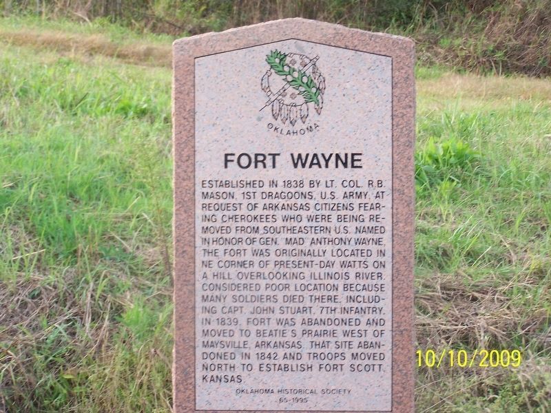
Fort Wayne Marker
| On U.S. 59 at Main Street, on the right when traveling south on U.S. 59. |
| On State Highway 11, 6 miles east of U.S. 64, on the left when traveling west. |
| On State Highway 11 west of County Road 630, on the left when traveling west. |
| On Main Street (U.S. 64) at 1st Street, on the right when traveling west on Main Street. |
| On Harper Road, 1 mile west of State Highway 38, on the right when traveling west. |
| On Court Street east of Delaware Avenue, on the right when traveling east. |
| On Court Street east of Delaware Avenue, on the right when traveling east. |
| On Court Street at Reba McIntire Street, on the right when traveling east on Court Street. |
| Near North Mississippi Avenue (U.S. 69) 0.8 miles north of West Liberty Road (U.S. 75), on the right when traveling north. |
| On Court Street east of Delaware Avenue, on the right when traveling east. |
| On Court Street at Reba McIntire Street, on the right when traveling east on Court Street. |
| On North Mississippi Avenue (U.S. 69) south of Ash Street, on the right when traveling south. |
| On State Highway 23, 8 miles south of U.S. 412, on the left when traveling south. |
| On Main Street, on the right when traveling east. |
| On U.S. 64, on the left when traveling west. |
| On U.S. 64 at State Highway 23, on the right when traveling east on U.S. 64. |
| On U.S. 64 at N1680 Road, on the right when traveling east on U.S. 64. |
| On Mendenhall Street (County Route 12) 0.1 miles north of Panhandle Street (U.S. 64), on the right when traveling north. |
| On County Highway 1230 at County Highway 2000, on the left when traveling west on County Highway 1230. |
| On West 2nd Street, on the right when traveling west. |
| On U.S. 66, on the right when traveling east. |
| On West 2nd Street, on the left when traveling west. |
| On West 2nd Street, on the right when traveling west. |
| On U.S. 66, on the left when traveling east. |
| On U.S. 66, on the left when traveling east. |
| On U.S. 66, on the left when traveling east. |
| On West 3rd Street (Business Interstate 40) west of North Pioneer Road, on the right when traveling west. |
| On West 3rd Street (Business Interstate 40) west of Pioneer Road, on the right when traveling west. |
| On U.S. 66, on the left when traveling east. |
| On U.S. 66, on the left when traveling east. |
| On U.S. 66 near North Pioneer Road, on the left when traveling east. |
| On South Sheb Wooley Street south of West 3rd Street, on the right when traveling south. |
| On East Main Street (U.S. 66). |
| On East Main Street (U.S. 66). |
| On Bank X Road at Bank 19 Road on Bank X Road. |
| On North 4th Street (U.S. 283) at Elm Avenue, on the right when traveling north on North 4th Street. |
| On Old Route 66, 0.2 miles west of Texas Avenue, on the right when traveling west. |
| Near State Highway 58 south of County Highway 990. |
| On N2660 Road, on the right when traveling north. |
| Near Local Road P20, 0.4 miles State Highway 8A, on the right. |
| On State Highway 8A, 3 miles north of State Highway 8, on the left when traveling north. |
| Near P10 Road, 1 mile west of 8A. |
| On U.S. 70, 0.1 miles east of Ballpark Road, on the right when traveling west. |
| On Ford Washita Entrance Road north of State Highway 199 when traveling north. |
| On Buffalo Street (State Highway 22) west of Main Street, on the right when traveling east. |
| On Buffalo Street (State Highway 22) west of Main Street, on the left when traveling east. |
| On Buffalo Street (State Highway 22) west of Main Street, on the right when traveling east. |
| On Buffalo Street (State Highway 22) at Main Street, on the right when traveling east on Buffalo Street. |
| On Buffalo Street (State Highway 22) west of Main Street, on the right when traveling east. |
| On Burney Street at South Franklin Street, on the right when traveling north on Burney Street. |
| On Timothy Drive north of Moore Avenue, on the right when traveling north. |
| On Alternate U.S. 69/75 north of Uptown West River Road, on the right when traveling north. |
| Near Hina Hanta Way east of Cale Switch Road, on the right when traveling south. |
| Near State Highway 199, 3.5 miles west of State Highway 78, on the right when traveling west. |
| On State Highway 199, 3.5 miles west of State Highway 78, on the left when traveling east. |
| Near State Highway 199, 3.5 miles west of State Highway 78, on the right when traveling west. |
| On State Highway 22, 2.3 miles west of State Highway 48, on the right when traveling west. |
| Near Nails Crossing Road, on the right when traveling west. |
| On East Central Boulevard (State Highway 9) 0.3 miles east of Southeast 7th Street, on the right when traveling west. |
| Near East Central Boulevard (State Highway 9) 0.3 miles east of Southeast 7th Street. |
| On East Central Boulevard, 0.3 miles east of Southeast 7th Street (State Highway 9), on the right when traveling west. |
| On West Broadway Street, 0.1 miles west of Southwest 2nd Street, on the right when traveling west. |
| On East Central Boulevard (U.S. 62) 0.3 miles east of Southeast 7th Street, on the right when traveling west. |
| On East Broadway Street at East 2nd Street, on the right when traveling east on East Broadway Street. |
| On East Central Boulevard (State Highway 9) 0.3 miles east of Southeast 7th Street, on the right when traveling west. |
| On East Central Boulevard (U.S. 62) 0.3 miles east of Southeast 7th Street, on the right when traveling west. |
| On East Central Boulevard (State Highway 9) 0.3 miles east of Southeast 7th Street, on the right when traveling west. |
| On West Broadway Street at Southwest 2nd Street, on the left when traveling west on West Broadway Street. |
| On East Central Boulevard (U.S. 62) 0.3 miles east of Southeast 7th Street, on the right when traveling west. |
| On East Central Boulevard (U.S. 62) 0.3 miles east of Southeast 7th Street, on the right when traveling west. |
| On South 1st Street, 0.2 miles north of SW Oklahoma Avenue, on the left when traveling north. |
| On East Central Boulevard (U.S. 62) 0.3 miles east of Southeast 7th Street, on the right when traveling west. |
| On West Broadway Street at North 1st Street (U.S. 281), on the right when traveling west on West Broadway Street. |
| On E. Central Boulevard at Wells Drive, on the right when traveling west on E. Central Boulevard. |
| On East Central Boulevard, 0.3 miles east of Southeast 7th Street, on the right when traveling west. |
| On East Central Boulevard (State Highway 9) 0.3 miles east of Southeast 7th Street, on the right when traveling west. |
| Near East Central Boulevard (State Highway 9) 0.3 miles east of Southeast 7th Street. |
| On East Central Boulevard (U.S. 62) 0.3 miles east of Southeast 7th Street, on the right when traveling west. |
| On East Central Boulevard (U.S. 62) 0.3 miles east of Southeast 7th Street, on the right when traveling west. |
| On West Broadway Street at South 1st Street, on the left when traveling west on West Broadway Street. |
| On East Central Boulevard (U.S. 62) 0.3 miles east of Southeast 7th Street, on the right when traveling west. |
| On East Central Boulevard (State Highway 9) 0.3 miles east of Southeast 7th Street, on the right when traveling west. |
| On East Central Boulevard (State Highway 9) 0.3 miles east of Southeast 7th Street, on the right when traveling west. |
| On East Central Boulevard (State Highway 9) 0.3 miles east of Southeast 7th Street, on the right when traveling west. |
| On East Central Boulevard (U.S. 62) 0.3 miles east of Southeast 7th Street, on the right when traveling west. |
| On West Broadway Street at Northwest 3rd Street, on the right when traveling west on West Broadway Street. |
| On U.S. 281, 0.1 miles north of Wichita Lane, on the right when traveling north. |
| Near East Central Boulevard (State Highway 9) 0.3 miles east of Southeast 7th Street. |
| On East Central Boulevard (U.S. 62) 0.3 miles east of Southeast 7th Street. |
| On East Central Boulevard (U.S. 62) 0.3 miles east of Southeast 7th Street, on the right when traveling west. |
| Near East Central Boulevard. |
| On East Central Boulevard (U.S. 62) 0.3 miles east of Southeast 7th Street, on the right when traveling west. |
| On East Central Boulevard (U.S. 62) 0.3 miles east of Southeast 7th Street, on the right when traveling west. |
| On East Main Street at Northeast 3rd Street, on the right when traveling west on East Main Street. |
1356 entries matched your criteria. The first 100 are listed above.
Next 100 ⊳