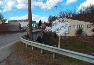
The Broad Run Baptist Church was organized in 1804. (2 Mi.W.) In its cemetery are buried many early settlers. Here is grave of Gen. Jos. A. Lightburn of the Union Army. After the War between the States, he became a Baptist minister. — — Map (db m78394) HM
Pioneer cabin built by Henry McWhorter a Revolutionary soldier, in 1793, at McWhorter's Mill, now Jane Lew and used as home, church, school, and postoffice, was moved to its present site and presented to the state by his descendants August 14, . . . — — Map (db m197580) HM
On September 21, 1833, an arm of Upper Falls of Coal River Church met at the forks of Coal River. The group petitioned, May 1834, and on June 21, 1834, became a distinct church, Forks of Coal River Church, with 25 members. A log meeting house was . . . — — Map (db m137393) WM
Hamlin became county seat, 1869. First court met, 1867, at Hamline Church (1 Mi. away), where, 1852-53, the Virginia Legislature established town of Hamline, named for Bishop Leonidas Lent Hamline of the Methodist Episcopal Church. — — Map (db m126883) HM
Site of Williams Memorial Methodist Episcopal church, now Central United Methodist, where Father’s Day was first observed on July 5, 1908. Reverend Webb conducted the service upon the request of Mrs. Charles Clayton, daughter of Methodist minister . . . — — Map (db m172306) HM
Ahead near Pierpont Avenue stood the home of
Francis Harrison Pierpont, governor of the Restored
Government of Virginia and the “Father of West Virginia.” Here he brought his bride, Julia Augusta Robertson Pierpont, in 1854. Here their . . . — — Map (db m75030) HM
Cast in 1909, by C.S. Bell & Co. Foundry - Hillsboro, OH
From 1911 - 1969 this bell hung in the bell tower over the original St. Anthony Church, 1547 Beverly Rd.
It was moved to this location in 1969 and sat behind the
church under the . . . — — Map (db m181294) HM
This church bell cast in 1892 at McShane Bell Foundry, Baltimore, MD. was refurbished and this bell tower constructed in 2002 to commemorate the founding of
the Church in 1852. It rings in honor of former, present and future parishioners and . . . — — Map (db m175336) HM
Born in 1878 in Basnettville, Marion Co. President of Women's Christian Temperance Union by 1908; led state suffrage movement in 1917, resulting in 1920 passage of 19th Amendment giving women right to vote. She was first woman to chair WV Republican . . . — — Map (db m189043) HM
Born January 20, 1820, Trainer worked as a tailor before becoming a Methodist minister. An opponent of secession, he was a delegate to the state's first Constitutional Convention and served as chaplain of the 12th WV Infantry during the Civil War. . . . — — Map (db m189433) HM
This building was built between 1886-89 for the St. Paul Methodist Episcopal Church, South. In 1942 it was sold to the Church of Christ in Christian Union. An earlier building, built in 1834 on this site was the First Methodist Church, which was the . . . — — Map (db m189709) HM
This church was built in 1884 and was known as the
First Baptist Church. Although not the first church
built in town, it is the oldest church building now
standing. — — Map (db m189746) HM
The Methodist Episcopal Church had this building
erected in 1887. In 1889, the name was changed to
Trinity Methodist Episcopal Church. In 1939, St.
Paul's Methodist Episcopal Church, South, united
with this congregation to form Trinity . . . — — Map (db m189745) HM
Believed to have been a Shawnee altar stone made by the Water Panther Clan, which was Cornstalk's Clan, this stone was found at nearby Leon, WV, at 10-Mile Creek. The spiral shape of the tail is believed to represent the whirlpools that were in the . . . — — Map (db m178630) HM
Old Union Blacksmith Shop on East Street was on this Square, as well as a second one located at 107 West Street. The first school building built for white children stood where the Magistrate Court Annex is now located on West Street. About 1870 a . . . — — Map (db m152820) HM
Oldest church building in Keyser, located on Church Street, built in 1876. It is an active, historically African American United Methodist Church today. — — Map (db m196537) HM
This Memorial is to pay tribute to Keyser's Medal of Honor recipient Jonah Edward Kelley. Born and raised in this area, Ed Kelley represented the best of West Virginia—character, values, hard work and sheer determination to do what's . . . — — Map (db m152792) HM
Located at the top of the Cliffs on Overton Place. During the Civil War, a 9 pound cannon was placed on the large rock facing South, up the New Creek Valley. Standing where Fort Piano can be seen to the left, Fort Fuller (Fort Kelly) to the right . . . — — Map (db m196519) HM
Congregation was organized in 1849. The church, constructed in 1850 of lumber produced on a water-powered sawmill and furnished with seats of chestnut, hand finished, is in an excellent state of preservation. It was first used as a combined church, . . . — — Map (db m36836) HM
The Church was established in 1892 in a little one room
wooden structure. It remained as that structure until around
1919 when a new structure was built to replace it. During
the Matewan Massacre in 1921, the residents of the . . . — — Map (db m164957) HM
Built before the Civil War on land donated by Rufus E. and Elizabeth Conn in 1854, this church was the meetinghouse for congregations of Episcopal, Presbyterian, Methodist Episcopal and Methodist Protestant denominations. It was placed on the . . . — — Map (db m153204) HM
First Methodist Protestant Church
Founded 1830
Old Stone House
Chestnut Street
Cornerstone Laid
September 7, 1907
Spruce and Fayette Streets
Morgantown, West Virginia — — Map (db m172507) HM
Who on the 24th day of March 1846 gave the land on which this church is built to be used to erect a house for the worship of the Holy Creator, God, forever.
This plaque is presented in memoriam by all who have found blessed salvation . . . — — Map (db m173502) HM
This fountain was originally located at Holy Rosary Parish in Clarksburg, WV and was utilized as a baptismal font from 1909 to 1984. When Holy Rosary Parish closed in 1984, the font was relocated to Mary Help of Christians Parish (St. Luke's Mission . . . — — Map (db m175649) HM
The Mt. Tabor Baptist Church was one of the earliest churches established in Monongalia County, VA. Revolutionary War Patriot Benjamin Wilson and his wife Eleanor donated an acre of land for the church and cemetery in 1803. The Works Progress . . . — — Map (db m186234) HM
Oldest stone house in Monongalia County. By legend built by Jacob Nuze on original lot 25. Sold 1795 to tavern-keeper Henry Dering. Owned 1800 - 1813 by potters John Thompson and Jacob Foulk. Bought by Joseph Shackelford who operated a tanyard here . . . — — Map (db m64090) HM
Oldest stone house in Monongalia County. By legend built by Jacob Nuze on original lot 25. Sold 1795 to tavern-keeper Henry Dering. Owned 1800 - 1813 by potters John Thompson and Jacob Foulk. Bought by Joseph Shackelford who operated a tanyard here . . . — — Map (db m235205) HM
On the third day of March 2002, on the feast of St. Casimir, the people of the new Catholic community of
Saint Francis De Sales, Morgantown, West Virginia,
gathered at this site along with their Bishop, Bernard W. Schmitt, to break ground for . . . — — Map (db m178653) HM
William Stewart settled here in 1771. Northeast was Fort Dinwiddie. Pioneer minister John Corbley, whose wife and three children were killed in 1782 Indian raid on Garard's Fort, founded Forks of Cheat Baptist Church here in 1775. — — Map (db m189510) HM
The Forks of Cheat Baptist Church, organized by the Rev. John Corbly on November 5, 1775 with 12 charter members, has the distinction of being the oldest church with continuous records west of the Alleghenies in what is now West Virginia. It . . . — — Map (db m229009) HM
The name Woodburn derives directly from Woodburn Female Seminary, which occupied this site before the university was established in 1867. Woodburn means grove of trees and it described the grove of beech trees which once covered the area. Completed . . . — — Map (db m164635) HM
Neighbors from Across the Pond
Many immigrants that settled in Star City after 1907 came from Italy and Eastern European countries. According to the 1920 census, 802 residents were born in Italy, 106 were born in Czechoslovakia (now The . . . — — Map (db m200205) HM
It was here in Star City that John F. Kennedy announced his intention to enter the West Virginia primary as a candidate for the Presidency of the United States. This decision was motivated by deep concerns within his party that a Roman Catholic . . . — — Map (db m114665) HM
The oldest denomination of Christians west of the mountains on the Waters of the Cheat and Monongahela Rivers in the Commonwealth of Virginia (now West Virginia).
First meeting house erected of logs on the highest point in the graveyard near . . . — — Map (db m74598) HM
The West Warren Baptist Church, originally known as The
West Warren Regular Baptist Church of Christ, was
organized in 1854. Members of the new church body had
been previously affiliated with the Union, St. Paul and
Harmony Baptist Churches. . . . — — Map (db m164946) HM
William J. Humphreys. Nearby noted meteorological physicist born 2/3/8162; died 11/10/1949. John Hopkins U. Ph.D., 1897; Director Mt. Weather Observatory 1905; famous for 1909 research on stratosphere; retired, Weather Service, 1935. Winds . . . — — Map (db m83986) HM
Born at Union, 1865. Converted at 15 at Simpson M. E. Church, Charleston. Licensed to preach; his first parish was Harpers Ferry 1889. His most distinguished pastoral work was the rebuilding of Asbury Church Washington, with a seating capacity of . . . — — Map (db m84106) HM
First bishop of American Methodism, Francis Asbury, was present at the raising of the church, 1785; dedicated this log meeting house, 1786; and held three annual conferences in May, 1792, 1793, 1796.
The church was built chiefly by the means . . . — — Map (db m84023) HM
Oldest extant Protestant church west of the Alleghenies. Erected 1786 on land donated by Edward Keenan. Bishop Francis Asbury preached here in July 1788, held three Methodist conferences in 1790’s, and performed the first Methodist ordination west . . . — — Map (db m59267) HM
Organized Aug. 7, 1783 as good hope meeting house. It was the second church organized west of the Allegheny Mountains by the
Rev. John McGue.
The present church was built in 1922
during the pastorate of Robert Russell Gray, D.D. — — Map (db m243172) HM
Presented by
Fr. Patrick J. Gillooly
Assembly 3214
Knights of Columbus
Dedicated to all Catholic men & woman
who have served God and Country — — Map (db m117299) WM
Harry Dorsey Gough, a wealthy Marylander from Perry Hall and a patron of Methodist Bishop Francis Asbury. Rev. Asbury visited and preached in the Gough house while in Bath. Gen. Horatio Gates was later a resident but never owned the lot. Capt. John . . . — — Map (db m117391) HM
The Town of Bath was plotted on land that had belonged to Thomas Lord Fairfax. These two lots were purchased on August 26, 1777, by six men on behalf of a German church. Although the original plan was to build a church and two houses on these lots, . . . — — Map (db m117409) HM
Site of the Snyders Evangelical Church founded by Jacob Albright in 1850. Merged with United Brethren Church in 1952. Razed in 1957. — — Map (db m97114) HM
On this site, from 1888 - 1996, stood the first African-American Methodist church in Morgan County. Mount Olive United Methodist Church, formerly Paw Paw Methodist Episcopal Church, was built by trustees: William Blue, William Ruebottom, George . . . — — Map (db m148842) HM
1831 - Land made available for a Methodist church.
1867 - Building built on this site as Stroud's Creek Methodist Episcopal Church. Later named for Reverend Samuel Black.
1892 - Church building repaired and enlarged. . . . — — Map (db m178866) HM
Organized on April 17, 1824 by twelve
members from the Hopewell Church in
Fayette County at the home of Henry
Morris on Peter’s Creek. The first
building of frame, constructed in
1840, was destroyed by Union soldiers
in 1861. The building was . . . — — Map (db m138064) HM
Oldest church in Nicholas County. Founded
by Backus, Walker, Johnson, Linager,
Brown, Nutter, dorsey, Simms, Gross
& Hamrick families. Served by circuit
rider meeting in homes until log church
built, 1810. Blacks attended; services
alternated . . . — — Map (db m138060) HM
Brooke County. Formed in 1797 from Ohio County. Named for Robert Brooke, Virginia governor, 1794-1796. Here Alexander Campbell founded the Christian Church and established a college. First Grimes Golden apple tree in this county.
Ohio . . . — — Map (db m176459) HM
The first Catholic nursing sisters in Wheeling, Sisters of St. Joseph, arrived in 1853 to operate Wheeling Hospital. During the Civil War, they nursed Union and Confederate soldiers and military prisoners. In 1864. several Sisters received . . . — — Map (db m189410) HM
This plaque commemorates the first Mass in what is now West Virginia August 13, 1749, and the establishment of the Catholic Diocese of Wheeling July 19, 1850. — — Map (db m196367) HM
Methodist minister and educator Gordon Battelle was a delegate to state's first Constitutional Convention in 1861. Battelle was instrumental in the inclusion of free public education, but his efforts at gradual emancipation of slaves failed. In . . . — — Map (db m142391) HM
Erected by the grateful Parish of
Our Lady of Mount Lebanon
in honor of those who served
their country and dedicated
to the memory of those who
gave their lives for our liberty
World War II
David Brice • Joseph Bryan • Nicholas . . . — — Map (db m83125) WM
Founded 1819
Erected 1866
Consecrated 1888
May the Gospel be preached, the Sacraments administered, and prayers and praises offered in this place, from generation to generation. — — Map (db m176796) HM
This base and fluted columns are from the interior of the first St. Joseph Cathedral which stood on this site from 1849 until it was torn down in 1923. This base and column pieces were discovered in excavations under the Cathedral during the 1996 . . . — — Map (db m176804) HM
They arrived in Wheeling, April 13, 1853 to teach, nurse in hospitals, take care of orphans, and help the poor. They left Carondelet (St. Louis) Missouri by boat, traveling down the Mississippi River to Cairo, Illinois and then up the Ohio River to . . . — — Map (db m196365) HM
Site of 31 acre vineyard owned and operated by Father John Peter Kreusch (1818-88), German priest who served Saint Alphonsus German Catholic Church (1859-83). Vineyard, set circa 1862, yielded from 4,000 to 15,000 gallons of unadulterated altar wine . . . — — Map (db m64228) HM
61 rods west stood original
round log church upon 3½
acre plot, deeded Dec.18, 1769,
by John Michael Propst and his
wife, Catherine, “for the congregation of the South Fork of the
Potowmack for five shillings
current money of Virginia.” — — Map (db m123901) HM
Near this site, in May 1862, following the battle of Mcdowell, General "Stonewall" Jackson received orders to return to the Shenandoah Valley while attending church service with the army. — — Map (db m34530) HM
Following the Battle of McDowell on May 8th 1862, Confederate General "Stonewall" Jackson pursued retreating Union forces under the command of Generals Schenck and Milroy to Franklin. As was his custom, Jackson called for a day of prayer and . . . — — Map (db m180860) HM
“The Wilfong Church.” Four acres of land for church and
cemetery were purchased for one
shilling on October 1, 1794 from
German immigrant couple, Michael
and Sophia Wilfong. Historically and
locally known as “The . . . — — Map (db m123921) HM
Oldest log church building in Pendleton Co. Built in 1848 of hewn white pine logs cut nearby. Served as Methodist Episcopal Church until 1910 when abandoned. Used as community center since rededication in 1936. — — Map (db m50400) HM
Built about 1850 as Methodist Episcopal Meeting House and known as Palestine Church. First trustees: Alfred Kimble, Jacob L. Kimble, J.H. Lantz, Abraham Kile, and Isaac Ault. Bought by Espiscopal Church, 1831; rededicated 1966. — — Map (db m99525) HM
Huntersville JailHuntersville was the county seat of Pocahontas, 1821-1891. Jail was built about 1878 of white Medina sandstone and considered almost an escape-proof structure. It was used until county seat was moved to Marlinton in 1891. . . . — — Map (db m34194) HM
Rev. John Stough and family settled at Mount Carmel about 1787, and about 1790 Stough started the first gristmill. The first church was the Salem Evangelical Lutheran Church, organized between 1792 and 1796. — — Map (db m156431) HM
Rev. John Stough and family settled at Mount Carmel about 1787, and about 1790 Stough started the first gristmill. The first church was the Salem Evangelical Lutheran Church, organized between 1792 and 1796. — — Map (db m235170) HM
Patrick J. Browne 1914-16
Paul D. Othling 1917-33
Paul V. Helsley 1933-50
Joseph A. Brumfield 1950-80
Robert A. Perriello 1980-81
The Passionist Fathers 1981- — — Map (db m182684) HM
Old Rowlesburg Church Property
First School, City Hall, Church
Telegraph Office
Est. c. 1848
Downtown Rowlesburg Historic District — — Map (db m200784) HM
This First Church Building
erected in 1900
has been placed on the
National Register
of Historic Places
by the United States
Department of the Interior — — Map (db m233778) HM
Barbour County
Attractions
Alderson-Broaddus College. This private coeducational college is situated on a beautiful 170-acre campus overlooking Philippi, site of the first land battle of the Civil War. Its excellent performing arts . . . — — Map (db m239336) HM
Chartered in 1837, the town of Buffalo predates the formation of Putnam County in 1848. Possibly named
after the nearby Big Buffalo Creek, the town was from its beginnings inextricably tied to river trade and
to agriculture. In its early days, . . . — — Map (db m137327) HM
Hurricane Baptist Church. Hurricane Baptist Church was founded May 26, 1860, near the old Hurricane Bridge. F. H. Reynolds was first clerk and James Mitchell the first moderator. This log meeting-house was burned in 1863 by soldiers of the . . . — — Map (db m238017) HM
During the deadly Spanish influenza pandemic of 1918-19, a special flu hospital operated on this site in the basement of the First Baptist Church. Volunteers, risking their own lives, tended to the plague victims brought in from throughout Raleigh . . . — — Map (db m159733) HM
Coal Marsh Missionary Baptist Church was built in 1829 of rough logs. Guyandotte Church moved in July 1836 to petition the Greenbrier Convention for a new church at Coal River Marshes, then Fayette County. Upon approval, all members living east of . . . — — Map (db m221285) HM
The Methodist Church had its roots in Beverly from the time of its settlement. Services were first held in the private homes and lawns of congregation members. The first "church" was the log home of Dr. Benjamin Dolbeare, the first physician in . . . — — Map (db m158754) HM
The Beverly Presbyterian Church came into existence as part of the United Congregations of Tygat Valley in 1788 and was formally organized on March 1, 1820 under Reverend Aretas Loomis. Services were held in the 1808 courthouse until the first . . . — — Map (db m24735) HM
Bishop Francis Asbury, famed Methodist circuit rider, often visited the Potomac, Tygart’s, Greenbrier, and Monongahela Valleys. In 1790, on a journey from Georgia to New England, he preached at cabin of Benjamin Wilson in Tygart’s Valley. — — Map (db m82321) HM
Tygart's Valley Presbyterian Church, organized in 1820. A brick building erected three-fourths mile west at the cemetery was destroyed by Union soldiers in 1862-1863 and the bricks used for building flues at the winter quarters. — — Map (db m46331) HM
Formerly
The First Methodist Church
Organized in 1851
and
The Grace Methodist Church
Organized in 1870
Consolidated September 22, 1940 — — Map (db m189970) HM
Forest Hill United Methodist Church, founded in 1835, served as temporary shelter in 1863 for 23rd Ohio Vol. Inf., including Col. R.B. Hayes and Major W. McKinley, later presidents of U.S. Preceding frame church building, 2nd on site, was one of the . . . — — Map (db m99128) HM
1st frame church in the
area, located .8 mi, NW.
Built 1852 in the Greek
Revival style, Prominent
local brothers Gordon &
Thomas Jordan gave land
and lumber. Used by the
Methodists many years. — — Map (db m132566) HM
When you top the steps of the tower,
you will be on Pipestem State Park's
highest point (3,000 feet) and facing east
across the Appalachian Plateau. Looking
through the gap in the mountains to the
southeast you see where New River and
the . . . — — Map (db m166437) HM
Trustees
Thomas Harris •
Alexander Harris •
Dennis Haynes •
Those
Interned
Unknown Tunnel Workers Post 1876 •
Lena Brooks 1901-1953 •
Thomas Harris 1828-1905 •
Jennie V. Brooks 1898-1951 •
John Henry Mann 1862-1923 •
Baby . . . — — Map (db m165204) HM
Opened on this site in 1865 by Free Will Baptists led by local resident Rev. F. J. Cather. Chartered by the legislature June 26, 1868. Rev. A.D. Williams became the first president and served until 1870 when he resigned to become Superintendent of . . . — — Map (db m238019) HM
First Mothers'-Day Service, May 10, 1908.
Founder - Miss Anna Jarvis.
Minister - Dr. H. C. Howard.
Church School Supt. - Mr. L. L. Loar. — — Map (db m176376) HM
Presbyterians first began meeting in the homes of members in Fetterman in 1855. The Presbyterian Church of Fetterman was officially organized through the Presbytery of Redstone on July 27, 1856.
In 1864 it was reorganized and renamed the First . . . — — Map (db m180938) HM
About 500 graves of early Grafton
settlers, dating 1857-1917, are in
old cemetery located on land given
by Sarah Fetterman to St Augustine
Catholic Church. Headstones include
names of Irish and German emigrants.
Buried here is Thomas McGraw, . . . — — Map (db m75019) HM
St. Augustine was the first church built in Grafton,
to serve the many Irish Catholics who had come
to work on the railroad. The first church building
was built in 1857 on land donated by the heirs of
Wilford Fetterman. Reverend Father James . . . — — Map (db m176856) HM
Residential Architecture in Thomas
Modern society places value on home ownership, especially a house with land. However, families that moved from Europe or large cities such as New York in the early 20th century were not necessarily . . . — — Map (db m153071) HM
Settled by colonists from New England. French Creek Academy was important early school. Asa Brooks started religious services here, 1816, from which grew the Presbyterian Church. Here, 1828, was formed early total abstinence society. — — Map (db m178895) HM
Heavner Cemetery is the final resting place of many notable West Virginians, including Daniel D. T. Farnsworth, West Virginia’s second governor; George R. Latham, Union Colonel and statesman; and Laura Jackson Arnold, revered Civil War nurse and . . . — — Map (db m173429) HM