On Barbour County Highway (U.S. 250) at Arden Road (County Route 6), on the right when traveling north on Barbour County Highway.
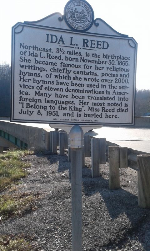
Northeast, 3 1/2 miles, is the birthplace of Ida L. Reed, born November 30, 1865. She became famous for her religious writings, chiefly cantatas, poems and hymns, of which she wrote over 2000. Her hymns have been used in the services of eleven . . . — — Map (db m165045) HM
On College Hill Road south of Circle Drive West, on the left when traveling south.
Named for Dr. Richard E. Shearer, President of Alderson-Broaddus College, 1951-1983.
During the Shearer Administration all the buildings on this quadrangle were erected except one which was completely remodelled. New Main replaced Old Main, . . . — — Map (db m211842) HM
On Runnymeade Road (County Route 26) at Soldier Drive, on the right when traveling west on Runnymeade Road.
300 yards west is one of the oldest Episcopal churches in West Virginia. Built in 1740 by Morgan Morgan. Five Revolutionary soldiers buried in church yard. Used as a barracks during war between the states. — — Map (db m134064) HM
On Winchester Pike (U.S. 11) just north of Old Mill Road, on the right when traveling north.
Nov. 1, 1688 — Nov. 17, 1766. Erected by the State of West Virginia. In commemoration of the first settlement within the present boundaries of said State, which was made by Col. Morgan Morgan, a native of Wales, and Catherine Garretson, his . . . — — Map (db m1169) HM
On Runnymeade Road (County Route 26) at Soldier Drive, on the right when traveling west on Runnymeade Road.
At Bunker Hill in 1726, Colonel Morgan Morgan founded the first permanent settlement of record in what is now West Virginia. In commemoration of this event, the state of West Virginia has erected a monument in Bunker Hill State Park, and has . . . — — Map (db m134056) HM
On Dominion Road, 0.1 miles south of Gerrardstown Road, on the left when traveling south.
Built by John Hays, 1743. Became home of Reverend David Gerard, who founded Gerrardstown in 1787. His father was Reverend John Gerard, the first Baptist Minister west of the Blue Ridge Mountains. — — Map (db m12793) HM
On Gerrardstown Road (West Virginia Route 51) 0.1 miles east of Reunion Corner Road, on the left when traveling west.
Established as a town, 1787. Named for John Gerrard, first pastor of Mill Creek Baptist Church, which was organized by early settlers about 1743. The congregation reorganized after Indian hostilities during the French and Indian War. — — Map (db m12791) HM
On Hedgesville Road (West Virginia Route 9) near Mt. Zion Street, on the right.
Site of stockade fort built during the early Indian wars. Mt. Zion Episcopal Church was built soon after. A mile west is the tavern, built, 1740–1750, by Robert Snodgrass on land patented in 1732 by William Snodgrass, pioneer settler. — — Map (db m990) HM
On South Spring Street at East John Street, on the left when traveling south on South Spring Street.
This structure was originally constructed as a dwelling and was later used as a house of worship from 1812-1842 by the Methodist Episcopal Church. — — Map (db m134000) HM
On South Queen Street (West Virginia Route 9) north of East John Street, on the right when traveling south.
This Romanesque Revival Church was begin in 1845 and dedicated in 1860. George Whitson, local architect, designed the Greek portico with the Gothic spire in 1888.
[Bottom plaque]
Most Reverend Bernard Schmitt, D.D.
Designated . . . — — Map (db m132395) HM
On Tuscarora Pike (County Route 15) west of Lost Road (County Route 13/1), on the left when traveling west.
Tuscarora Presbyterian Church, which was built before 1745 by Scotch-Irish Presbyterians. Rev. Hugh Vance, first pastor, is buried here. During Indian days, worshipers hung their guns on pegs in the walls while they sang and prayed. — — Map (db m92578) HM
On West Virginia Route 85, 0.1 miles north of Country Estates Road, on the left when traveling south.
Born in 1810 in present-day Boone
County, Methodist minister Robert
Hager was a delegate to the state’s
first constitutional convention in
Wheeling. 1861-1863. He supported
including a provision for gradual
emancipation in WV and also a . . . — — Map (db m138447) HM
On Main Street (West Virginia Route 67), on the right when traveling west. Reported missing.
Here lived the leading influence in America's largest indigenous religious movement, Christian Church (Disciples of Christ), and founder of Bethany College. Built in four periods: the John Brown Mansion, completed in 1793; Buffalo Seminary, in 1819; . . . — — Map (db m20826) HM
Born in Prince Edward Island, Canada, September 4, 1849
Died December 15, 1920
Fourth President of Bethany College
For thirty-nine years Chief Executive of the
Foreign Christian Missionary Society
Every missionary sent to . . . — — Map (db m20836) HM
On Main Street at Church Street, on the right when traveling east on Main Street.
Bethany Church of Christ, the oldest church building in Bethany, was built in 1852 according to plans drawn by Alexander Campbell, founder of Bethany College and leader in the Disciples Movement. Its foundation is built of stone from the original . . . — — Map (db m20830) HM
On Main Street (West Virginia Route 67), on the right when traveling east. Reported missing.
Here are buried the Campbell family; the first missionaries, other prominent leaders in the Disciples Movement, presidents and distinguished teachers of Bethany College. The seven foot hand hewed stonewall is a unique feature of Cemetery. — — Map (db m20963) HM
Born in County Down, Ireland, Feb. 1, 1763, and died at the residence of his son Alexander, Jan. 4, 1851, aged 91 years, 11 mthns, five days. Many years a minister of the Secession Presbyterian Church in Ireland and Scotland. In the United States . . . — — Map (db m20835) HM
Near Eldersville Road (West Virginia Route 27) at St. John's Road, on the right when traveling west.
Founded in 1793 by Joseph Doddridge. It is the first Episcopal Church west of the Alleghenies and the oldest continuous worshipping congregation within this religious body in West Virginia. The first church, made of logs, was burned by Indians. . . . — — Map (db m79897) HM
On Charles Street at 11th Street, on the left when traveling north on Charles Street.
Methodism in Wellsburg dates back to 1787 with the establishment of the “Ohio Circuit.” Early services were held in “The Academy” on High Street. Bishop Asbury preached at the courthouse on September 6, 1803.
On April . . . — — Map (db m21635) HM
On Guyan Street north of 5th Avenue, on the right when traveling north.
First located in Gallipolis, Ohio,
the house, owned by James Gallaher.
was floated down the Ohio River to
Guyandotte in 1810. Obtained by the
Carroll family, it was used as an
inn and site for Catholic Mass.
On November l1, 1861, Mary . . . — — Map (db m178157) HM
On 11th Street at Veterans Memorial Boulevard (U.S. 60), on the left when traveling south on 11th Street.
Born 1830 in Utica, NY, Oley was
in that state's National Guard and
came to western Virginia in 1861
to drill Union troops. He rose to
rank of brevet brigadier general
by war's end. In 1871 Oley settled
in Huntington and worked as land
agent . . . — — Map (db m178145) HM
On James River Turnpike Road (County Route 25) 1.6 miles Midland Trail (U.S. 60), on the right when traveling east.
Church completed, 1849. Occupied during the War Between the States by a Federal garrison to protect the one-lane covered bridge, which was a vital link in the James River and Kanawha Turnpike. The soldiers left the Church in shambles. It has been . . . — — Map (db m178194) HM
On Greenbrier Road (County Route 17) 2.2 miles west of Patterson Fork Road (County Route 29) when traveling west.
Crossing rivers and mountains from New Jersey, Seventh Day Baptists came in 1789-90 to Virginia and established their church at New Salem. In 1870 a daughter church was organized on Greenbrier Run, Rev. Jacob Davis first pastor; Rev. Walter B. . . . — — Map (db m228822) HM
On Greenbrier Road (County Route 17) 0.9 miles west of Patterson Fork Road (County Route 29), on the right when traveling west.
Site of Greenbrier Seventh Day Baptist Church, organized Aug. 1870 by members of New Salem church, est. 1792 in Salem. Met in log building; new church dedicated, 1880; razed, 1975. Rev. Peter Davis (1783-1885), original settler & Rev. Jacob Davis . . . — — Map (db m142418) HM
On Rotan Street (Local Road 19/15) at Austin Street and King Avenue, on the right when traveling south on Rotan Street.
At the top of the hill here a community came together to help Jewish soldiers
keep their faith in the midst of war. In early April 1862, Pvt. Joseph A. Joel
and 20 other Jewish soldiers in the 23rd Ohio Infantry asked Col.
Rutherford B. Hayes, a . . . — — Map (db m223876) HM
On Stanford Road (West Virginia Route 41) 0.2 miles north of County Road 41/27, on the right when traveling north.
In 1870 the Quinnimont Charter Oak and Iron Company built an iron furnace on Laurel Creek, which operated for three
years. The main line of the Chesapeake and Ohio Railway was completed through the gorge in the spring of 1873, and by
fall the . . . — — Map (db m165223) HM
On Little Kanawha Parkway, 0.1 miles east of Job Run Road (County Road 35/4), on the left when traveling east.
Begun, 1860; finished after the Civil War; handhewn log church is oldest in Gilmer Co. Job's Temple Class of M.E. Church, South was organized in 1866 by the Rev. G.S. McCutchen, first pastor. First trustees were Levi Snider, Salathiel, Wm. & N.W. . . . — — Map (db m190018) HM
On Little Kanawha Parkway (West Virginia Route 5) 0.1 miles east of Job Run Road (Route 35/4), on the right when traveling east.
Begun. 1860; finished after the
Civil War; handhewn log church
is oldest in Gilmer County. Job’s Temple Class of Methodist Evangelical Church South was organized in 1866 by the Rev. G.S. McCutchen, first pastor. First trustees were Levi Snider, . . . — — Map (db m174391) HM
The brick church formerly on this site was named Mount Zion Presbyterian Church. The congregation stopped meeting here after Federal forces occupied Petersburg in May 1862, took over the church building, and began using it as a commissary. The . . . — — Map (db m58681) HM
On Virginia Avenue (West Virginia Route 55) east of Main Street (U.S. 220), on the right when traveling east. Reported missing.
Settled about 1745. Near by was Fort George, Indian fort. Federal trenches overlooked the town in 1863 and 1864. Here is grave of Rev. W. N. Scott, pioneer preacher, who built churches at Old Fields, Moorefield, and Petersburg. — — Map (db m162730) HM
On Riverview Avenue (West Virginia Route 12) at Monroe Street, on the right when traveling east on Riverview Avenue.
Settled in 1777 by “Elder” John Alderson, the frontier missionary. He organized the first Baptist church in the Greenbrier Valley. In 1763, the Muddy Creek settlements were destroyed by Shawnee Indians under Cornstalk. — — Map (db m76515) HM
On North Monroe Street north of Walnut Avenue, on the right when traveling north.
Alderson Academy opened September 18, 1901, a coeducational secondary school founded mainly through the efforts of Miss Emma C. Alderson. Closely associated with Greenbrier Baptist Church, after 1910 control was assumed by W. Va. Baptist . . . — — Map (db m76519) HM
On Church Street south of Foster Street, on the left when traveling south.
Confederate dead were laid out in the Old Stone Church & then buried in the churchyard without ceremony. After the war their remains were moved to the present Confederate Cemetery. — — Map (db m75375) HM
On Courtney Drive at Washington Street (U.S. 60) on Courtney Drive.
Side A Site of Fort Savannah, built in 1755. Here at Camp Union Gen. Andrew Lewis mustered troops which participated in the Battle of Point Pleasant 1774. Lewisburg was incorporated in October, 1782, by the Virginia Assembly. Side B . . . — — Map (db m21747) HM
Confederate troops under Gen. Henry Heth here, May 23, 1862, were repulsed in attach upon division of Col. Geo. Crook's brigade. The Old Stone Church was used as a hospital. In his retreat, Heth burned bridge over Greenbrier at Caldwell. — — Map (db m19380) HM
On Church Street south of Foster Street, on the left when traveling south.
For sixty two years, the Beloved Pastor of Lewisburg Church. A faithful servant of God and a Pioneer of Presbyterianism in a vast part of Virginia. — — Map (db m75364) HM
On Washington Street (U.S. 60) near Livesay Street, on the right when traveling west.
Named in honor of Jehu Lewis Shuck, first American Baptist Missionary to China in 1835 and a member of Big Levels Baptist Church, established in 1796.
Reorganized in 1927.
This building erected in 1938. — — Map (db m140683) HM
On Kanawha Avenue (U.S. 60) 0.1 miles east of S. Sewell Street (West Virginia Route 20), on the left when traveling east.
Meadow River Lumber CompanyEstablished as Raine-Andrew Lumber Co. concern with purchase of 32,000 ac. (1906-08) by John & Tom Raine, namesake of Rainelle, founded 1908. Used logging railroad from woods to mill & Sewell Valley RR (NF&G) to C&O. . . . — — Map (db m50391) HM
On Midland Trail W Road (U.S. 60) near junction with Sam Black Church Road (County Route 60/5), on the right when traveling east.
Built in 1901, church building was dedicated in memory of the Rev. Sam Black (1813 - 1899). He preached here in the 1880s - 90s. Born in Rupert & licensed in 1840, Black was a Methodist circuit rider almost fifty years. Sam Black Church, a spiritual . . . — — Map (db m55766) HM
On Northwestern Turnpike (U.S. 50) just west of West Gravel Lane, on the right when traveling west.
Mt. Pisgah Benevolence Cemetery, since the 1800's, has been land for cemetery burial for black slaves, men who served in the Armed Forces, a governess who served for 25 years for the late Governor John Cornwell, two brothers who were barbers, . . . — — Map (db m150661) HM
On North High Street (West Virginia Route 28) just south of Larson Place, on the left when traveling north.
This property is listed in the
National Register
of Historic Places
by the United States
Department of the Interior
Old District
Parsonage
c. 1872 — — Map (db m150649) HM
On West Rosemary Lane at North Marsham Street, on the right when traveling west on West Rosemary Lane.
Presbyterian Church was first organized in Romney in 1787, after supplications dating as early as 1740. The present church was erected in 1860. It was used as a stable and hospital during the war between the states. — — Map (db m128846) HM
On South High Street just north of East Gravel Lane, on the right when traveling south.
Francis Taggart (also spelled Tygart) A Quaker, was responsible for the construction of this Clapboard "Half" House on one of the one hundred lots which Lord Fairfax had surveyed to encourage settlement of the western countries. According to his . . . — — Map (db m150639) HM
On Three Churches Hollow Road at Jersey Mountain Road on Three Churches Hollow Road.
The Presbyterians established a church near here in 1792. At first called the Mountain Church in 1808, it became the nucleus of Presbyterian work in Hampshire County under the auspices of the Rev. John Lyle. The Rev. James Black reorganized the . . . — — Map (db m19356) HM
On North River Avenue at Jefferson Avenue, on the right when traveling south on North River Avenue.
Side A:Captain John Porter(August 7, 1838 - February 7, 1893) Early developer of New Cumberland, he operated line of steamboats and barges on Ohio River, Chelsea China Company and glass plants. Known as "brick king" he owned Sligo, . . . — — Map (db m44121) HM
On South 17th Street at Pennsylvania Avenue (West Virginia Route 105), on the right when traveling west on South 17th Street.
100 yards south is site of original log Three Springs Church. Built 1790 on land donated by James Campbell. Elisha Macurdy, first pastor, called Nov., 1799. The mother church of Cove and Paris United Presbyterian churches. — — Map (db m80385) HM
On West Virginia Route 259 at Lower Cove Road (Route 59), on the right when traveling south on State Route 259.
300 yards east is the first Lost River Valley Church. Built of logs, prior to 1797, on land deeded by Anthony Miller, 1831, to the Baptists and Presbyterians “to hold in common for a meetinghouse and graveyard.” — — Map (db m48935) HM
On South Main Street (U.S. 220) at Winchester Avenue, on the right when traveling north on South Main Street.
When the Civil War began, the Greek Revival-style Moorefield Presbyterian Church consisted of the main sanctuary that fronts on Main Street and the small chapel behind it. The chapel was constructed about 1847, and the sanctuary was completed in . . . — — Map (db m47863) HM
On South Main Street (U.S. 220) at Winchester Avenue (Old West Virginia Route 55), on the left when traveling south on South Main Street.
During the Civil War this church was used by both the North and South as a hospital. Union soldiers stabled horses here and burned pews for firewood. Federal government paid $800 indemnity in 1914. — — Map (db m9236) HM
On North Main Street (U.S. 220) just south of Williams Street, on the right when traveling south.
The Parsonage
circa 1853
has been placed on the
National Register
of Historic Places
by the United States
Department of the Interior
— — Map (db m153040) HM
On South Fork Road (County Route 7) 16.7 miles north of U.S. 33, on the right when traveling north.
Last of the Lutheran horseback circuit rides, who was known as a dynamic pastor, theologian, professor of history, philologist and a Christian gentleman.
Died 1952 A.D. — — Map (db m49580) HM
Near Benedum Drive (West Virginia Route 131) 0.1 miles north of Northwestern Turnpike (U.S. 50), on the right when traveling north.
The first building known as the Baptist Meeting House stood on this site. The church was organized about 1770 by Rev. John Sutton and five constituent members. Rev. James Sutton served as pastor for a short period. Rev. John Corbly served as pastor . . . — — Map (db m177155) HM
Near Benedum Drive (West Virginia Route 131) south of Park Avenue, on the right when traveling north.
Original site of the Simpson Creek Baptist Church (organized in 1770). Buried here are James "Peg" Clemens, Pony Express rider and cousin of Mark Twain; Joseph Johnson, the only man west of the Alleghenies to serve as governor of Virginia, and . . . — — Map (db m181303) HM
On Enterprise Road (County Road 19/2) just east of U.S. 19, on the right when traveling east.
Bathsheba Bigler Smith, born May 3, 1822, one mile upstream, was baptized in The Church of Jesus Christ of Latter - day Saints in 1837. Moved to Nauvoo, IL, where she was a founding member of the Relief Society, the LDS Church charitable women's . . . — — Map (db m177224) HM
On Buckhannon Pike (West Virginia Route 20) 0.4 miles south of Cost Avenue (West Virginia Route 58), on the left when traveling south. Reported missing.
Organized in 1818 by 19 members of Simpson Creek Baptist Church wanting a house of worship nearer to their homes. Original log building stood below road. Present structure was erected in 1854. — — Map (db m173715) HM
On Ravenswood Road (Route 68) 0.2 miles south of County Road 4/8, on the right when traveling north.
Erected in 1860 on land donated by Thomas Coleman, who donated half of building cost. Family and community members donated the balance. Service June 22, 1860. Deeded to Methodist Episcopal Church South. During the Civil War, Union Home Guard . . . — — Map (db m189754) HM
On Walnut Street at Ann Street, on the right when traveling west on Walnut Street.
This tablet marks the military grant of land 2448 acres made by King George II of England in the year 1772 to George Washington for his services in the French and Indian War. General Washington bequeathed 1425 acres of this tract to his niece . . . — — Map (db m228080) HM
On Court Street North at North Street West, on the left when traveling north on Court Street North.
Brother Harry Ripley was a circuit-riding minister for the Methodist church. According to legend, he had planned to wed a local girl and build the first church in the community. Tragedy struck, however, when he drowned in Mill Creek with their . . . — — Map (db m10915) HM
On South West Street at West Congress Street, on the right when traveling south on South West Street.
On February 17, 1787, Charles Washington, founder of Charles Town, executed a deed granting a lot to the Board of Trustees of the Charles Town Presbyterian Church. Washington was paid 20 pounds "current money of Virginia" for the lot which was in . . . — — Map (db m170356) HM
On South West Street at West Congress Street, on the right when traveling south on South West Street. Reported permanently removed.
The first school for African-Americans in Charles Town started in December 1865 at the home of Achilles and Ellen Dixon, African-Americans who lived on Liberty Street. It was taught by Freewill Baptist Missionary Anne Dudley.
Between 1868 . . . — — Map (db m132452) HM
On Middleway Pike (West Virginia Route 51) east of North Ridge Drive. Reported missing.
This chapel was built by devout people of (then) Frederick Parish. Frederick County, Virginia joined Col. Robert Worthington in completing it in 1769. It was first called the English Church, then Berkeley Church, then Norborne Chapel, as the parish . . . — — Map (db m2026) HM
On E Congress Street at S Church Street, on the right when traveling east on E Congress Street.
The present church, the fourth on this site, was completed in 1851. Federal troops occupied it during the Civil War and severely damaged it. The churchyard contains the graves of many Washington family descents. They are buried near the eastern . . . — — Map (db m41675) HM
On Fillmore Street east of Columbia Street, on the right when traveling east.
This house was built in 1858 as quarters for the U.S. Armory paymaster's clerk and his family. This clerk helped the paymaster manage the armory's complex budget and payroll, and assisted also with the collection of government quarters' rent and . . . — — Map (db m70750) HM
Near Church Street, on the right when traveling south.
These weathered ruins are all that remain of St. John's Episcopal Church - one of Harpers Ferry's five earliest churches. Built in 1852 with money provided by church fairs, St. John's served as a hospital and barracks during the Civil War and . . . — — Map (db m18790) HM
On Washington Street (Business U.S. 340) east of Boundary Street, on the left when traveling east.
The Reverend Doctor Josiah P. Smeltzer laid the cornerstone of St. John's Lutheran Church on April 30, 1850. The building was completed two years later and dedicated on August 1, 1852. Little more than seven years had passed when, at dawn on . . . — — Map (db m70794) HM
On Church Street, on the right when traveling east.
Construction of the Chesapeake and Ohio Canal and the Baltimore and Ohio Railroad produced an influx of Irish laborers into the Harpers Ferry area during the early 1830's. St. Peter's Catholic Church, completed in 1833, symbolizes America's melting . . . — — Map (db m18789) HM
Near Church Street just west of Public Way, on the right when traveling east.
High above the storied town of Harpers Ferry, with the tranquil waters of the Shenandoah River flowing just below, sits historic St. Peter’s Church. Deeply rooted in the rich history of the Church in West Virginia, the Civil War, and one of the . . . — — Map (db m124619) HM
On East Street (County Road 1/8) 0.1 miles north of Grace Street (County Road 1/8), on the left when traveling north.
Middleway, founded in the late 1700s, flourished as a trading center for most of the 1800s. About 1820 the Lutherans and German Reformed congregations joined together to build this church. Some years elapsed before the building was erected and . . . — — Map (db m157726) HM
On South Fairfax Boulevard (West Virginia Route 115) at Mildred Street and 4th Avenue, in the median on South Fairfax Boulevard.
A distinguished clergyman, humanitarian, and civic leader in the community. Bishop Baltimore served as Senior Bishop & General President of the King’s Apostle Holiness Church of God, Inc. He was Pastor of The Baltimore Temple Church for 51 . . . — — Map (db m2030) HM
On North Church Street (County Road 480/1) just north of Old Queen Alley, on the right when traveling north.
This Old English/Episcopal Cemetery contains the graves of these Revolutionary War soldiers: Maj. Henry Bedinger, Anthony Kerney, Lt. Daniel Bedinger, James Kerney Sr., William Morgan Jr., William Lemen, Caleb Levick, Robert Tabb, and the . . . — — Map (db m157759) HM
On W. German Street near Church Street, on the right when traveling east.
This house was acquired in 1995 by actress Mary Tyler Moore, a descendant of Conrad Shindler, and donated to the Shepherd College Foundation in honor of her father, George Tyler Moore. Between 1869 and 1995, this house served as the Reformed Church . . . — — Map (db m98159) HM
On West German Street at South Church Street, on the right when traveling east on West German Street.
Trinity Episcopal Church was first established in 1745, and its congregation worshiped in three buildings built on the site one block north on Church Street. In 1854, under the leadership of the Rev. Charles W. Andrews, DD, who served as rector . . . — — Map (db m107754) HM
On Stubb Road just south of West Dupont Avenue (County Road 60/12), on the left when traveling south.
This bell was installed in the Methodist Episcopal Church South when the building was completed and dedicated November 27, 1913 and given to the Town of Quincy by John Quincy Dickinson. It was presented to the Old Stone House by Jake Givens in . . . — — Map (db m178857) HM
On U.S. 60, 0.3 miles east of Kellys Creek Road (County Route 81), on the right when traveling east.
Virginia's Chapel was built in 1853 as gift for Wm. Tompkins' daughter, Virginia. Used by both sides during the Civil War, Methodists acquired church in 1901. Building lengthened in 19th cent., cupola added in 1912. Placed on National Register in . . . — — Map (db m50407) HM
On East Dupont Avenue (U.S. 60) at Woodmont Cemetery Drive, on the right when traveling south on East Dupont Avenue.
Founder and defender of Fort Morris, the first fort built on the Great Kanawha River in 1774, near this site. He also built the first church and school house and made the first permanent white settlement in the Great Kanawha Valley.
And of . . . — — Map (db m164712) HM
On Kanawha Boulevard East west of Ruffner Avenue, on the right when traveling west.
To the glory of God in loving memory for the life of Robert A. Pate July 1, 1930 Sept. 11, 1993 Founding pastor of Living Word Christian Center & School 1974 - 1993
My house shall be called the house of prayer Matthew . . . — — Map (db m228723) HM
On Malden Drive south of Wise Drive, on the right when traveling north.
Famous as the church of Booker T. Washington, this church began in 1852 with a group of enslaved Christians. During the Civil War, Pastor Lewis Rice organized them into one of the nation's first churches started and completely controlled by slaves. . . . — — Map (db m237984) HM
On Georges Drive at Malden Drive (County Road 60/6), on the right when traveling west on Georges Drive.
In cemetery nearby is grave of Dr. Henry Ruffner, eminent theologian and writer, called father of Presbyterianism in the Kanawha region. After his ministry, he became head of Washington College, Lexington, Va. Wrote Ruffner Pamphlet. — — Map (db m76879) HM
On North Pinch Road (County Route 47) close to Reunion Road, on the left when traveling north.
Oldest of its kind in nation. Founded in 1902 by William W. Wertz and other Elk River residents to raise the civic, religious and educational standards of the community. The group meets for three days every August at its home site, “Rockwood Glen.” . . . — — Map (db m140132) HM
On Main Street (U.S. 19) at Depot Street, on the right when traveling north on Main Street.
Two miles east stands the Old Harmony Church, built in 1819. In this church in 1829, John Mitchell and David Smith organized the first Methodist Protestant Church. Mitchell was its first pastor. Near the churchyard is his grave. — — Map (db m78396) HM
215 entries matched your criteria. The first 100 are listed above. Next 100 ⊳