Warm days, gold and crimson foliage, and migratory animals mark the season.
Sonoma chipmunks busily prepare for hibernation. They forage through the woods in search of seeds, nuts, and berries. When their cheek pouches are full, they dig a small . . . — — Map (db m92646)
Some of the world’s richest waters exist right off California’s coast. An explosion of life occurs here due to a combination of the sun’s energy, wind, ocean currents, and contours of the sea floor. Microscopic phytoplankton form the base of the . . . — — Map (db m63362) HM
The Marine Mammal Center is built on the site of the former Nike Missile Launch Area, SF 87L. In the 1950s, the army constructed two batteries in the Marin Headlands equipped with surface-to-are missiles, one near Fort Cronkhite and a second across . . . — — Map (db m102832) HM
For thousands of years Native Americans lived in the Bay Area harvesting animals, salt, and acorns. The changes they made to the landscape were limited. They used fire to shape oak woodlands and grasslands. cultivated plants, and collected salt . . . — — Map (db m102474) HM
Center Panel
Shaped by People
Humans changed Angel Island in many ways. We cut trees, brought animals, and plants, dug into the mountain, paved roads, and erected buildings. Yet nature persists, creating habitat for countless plants . . . — — Map (db m203632) HM
This picture, circa 1930, show remnants of oysters beds used by the Morgan Oyster Company. For an unknown reason, oyster spawn (eggs) would not thrive in the bay so oysters were brought in from Washington State and from the East Coast to be fattened . . . — — Map (db m204079) HM
Over 100,000 years ago Angel Island was part of the mainland and the ocean was 26 miles to the west. As glaciers from the last ice age melted, sea levels rose and saltwater filled the ancient river valley below, creating San Francisco Bay and Angel . . . — — Map (db m203781) HM
The view ahead could have looked quite different had the Reeds Port Project, a proposed development of several thousand homes, been built over Richardson Bay in the 1950s. Fortunately, this vital habitat was saved by concerned local residents who . . . — — Map (db m203902) HM
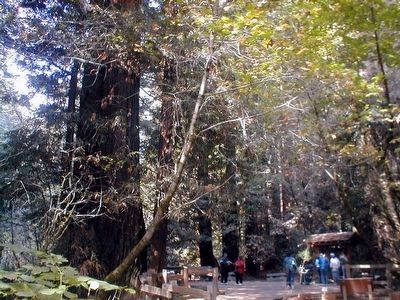
Creating an Experience to Match the Dignity of the Trees People have revered this Grove and its mighty trees for thousands of years. Through ecological restoration, the health and resilience of these giants will be protected and all visitors . . . — — Map (db m160409) HM
Tourism in Yosemite began long before it became a national park. In the 1850s, daring visitors endured long days of rugged travel on foot and horseback. Indian trails led them to never-to-be-forgotten views of Yosemite.
Entrepreneurs were soon . . . — — Map (db m81942) HM
Mirror Lake was once regarded by park scientists as a stream-fed lake slowly filling in to become a meadow. As hydrologists have developed a more complex understanding of the water's dynamics, they now theorize that the "lake" is a pool in a . . . — — Map (db m81952)
Just above Mirror Lake, bracken ferns grow in large tracts. The root-like portion of the fern (rhizome) is favored for making the black designs in Southern Miwok and Mono Lake Paiute baskets. Because of the rich sandy sediments here, bracken fern . . . — — Map (db m81953) HM
At certain times of the year some of the Valley’s waterfalls disappear. Bridalveil keeps flowing even in late summer, when Yosemite Falls begins to dry up.
Above Yosemite Falls the terrain is largely bare granite; runoff is rapid. Bridalveil . . . — — Map (db m63589) HM
El Capitan is famous for its massive bulk of largely unbroken rock and its sheer, vertical face soaring 3,000 feet into the air. This monolith is composed of a particularly durable granite, allowing it to withstand the pressures of glaciers and . . . — — Map (db m81949) HM
Geologic processes that created Yosemite Valley include glaciation, erosion, rockfalls, and earthquakes. Most of these processes are still at work here, shaping and reshaping the land. Ancient glaciers have left dramatic geologic evidence virtually . . . — — Map (db m81948) HM
In 1869, innkeeper James Hutchings hired a young wilderness explorer named John Muir to rebuild and operate his sawmill. Muir worked here for almost two years, milling trees blown down in a storm to build improvements at Hutchings’ Yosemite Valley . . . — — Map (db m66101) HM
For centuries, the local Indians use the bracken fern found above Mirror Lake. In the 1800s, Euro-American entrepreneurs found new uses for the area's resources. Hotel owners marketed the magnificent scenery to an enthusiastic audience or travelers. . . . — — Map (db m81951) HM
Perhaps only three or four hundred years ago, an enormous rockfall dumped boulders across this canyon, damming Tenaya Creek. During spring and early summer, the stream backs up into the two pools on either side of the dam.
Tinkering with . . . — — Map (db m81950) HM
This turnout was named in honor of famed landscape architect, Frederick Law Olmsted (1822-1903), and his son, Frederick, Jr. when Tioga road opened to automobile traffic in 1961. Olmsted senior was considered the father of American landscape . . . — — Map (db m65531) HM
On this site President Theodore Roosevelt sat beside a campfire with John Muir on May 17, 1903 and talked forest good. Muir urged the President to work for preservation and priceless remnants of America’s wilderness. At this spot one of our . . . — — Map (db m62853) HM
Mirror Lake's magnificent scenery was as much a commodity to be harvested as was the ice and sand. In the 1860s, entrepreneurs built a toll road to the lake, and here at the end of the carriage road, they opened an inn in 1870. Later the inn became . . . — — Map (db m81962) HM
Millions of years ago the granite block of Half Dome was larger, but there was never a matching half. Undercut by glaciers near the base, slabs of rock fell away from a broad vertical crack in the granite, leaving a sheer face. Remnants of the . . . — — Map (db m81963) HM
The opening of Yosemite to tourism in the 1850s coincided with America's glorification of nature and fascination with the picturesque. Early accounts of Mirror Lake are full of such sentiments. Visitors today still express many of the same emotions . . . — — Map (db m81961) HM
Nowhere else on earth are there so many spectacular waterfalls in such a concentrated area.
During the spring, torrents of water from melted snow thunder over Yosemite's precipices. By August, the "ephemeral" falls disappear; others, like the . . . — — Map (db m81943) HM
On June 30, 1864 the United States granted the Yosemite Valley and the Mariposa Big Tree Grove to the State of California to "be held for public use, resort and recreation...inalienable for all time." This act, signed by President Abraham Lincoln, . . . — — Map (db m81941) HM
The first Euro-Americans arrived in 1870 when Presley A. Dorris, Henry Fitzhugh, and several other Dorris family members drove cattle and horses into the area. With land granted under the Homestead Act, the Dorris family established a livestock . . . — — Map (db m113039) HM
This steep cliff of nestholes and crevices overlooks the Tule Lake National Wildlife Refuge and Lava Beds National Monument — fruitful hunting ranges for hawks, falcons, owls, and other birds of prey.
A favorable environment here is . . . — — Map (db m151904) HM
In Loving and Grateful Memory of
The C-130 Crew
Steve Wass, Craig Labare and Mike Davis
Who gave their lives to save
our community on June 17, 2002 — — Map (db m23036) HM
The Draw of Creative Minds
Wild ocean vistas, sculpted rocks, bold mountains, secluded arroyos, verdant creeks, fog-shrouded redwoods, and the rugged solitude of Big Sur have inspired artists for generations. Writers, poets, . . . — — Map (db m197751) HM
Limekiln
In the 1870s and 1880s, locally quarried limestone was kilned (smelted) in four huge wood-fired kilns. The powdered lime was then packed in barrels and cabled from the canyon down to the beach and out to ocean-going schooners . . . — — Map (db m196815) HM
Even though Monterey cypress trees prefer this area's rugged bare granite headlands, the Lone Cypress is a testament to the hardiness of these trees. It has withstood Pacific storms and winds for roughly 250 years. Fences and cables now offer added . . . — — Map (db m8476) HM
You are looking at the backyard of Ed Ricketts’s lab, Pacific Biological Laboratories, where Ricketts lived and worked during the 1930 and 1940s. He collected and preserved tide pool plants and animals and sold them to schools around the world. What . . . — — Map (db m55143) HM
Off the coast and beyond the breaking waves, giant kelp provides a lush home for marine life. Holding fast to the rocky bottom, these huge plants grow upward then spread their green-gold fronds across the water, creating a dense canopy of growth . . . — — Map (db m55161) HM
Pictured at the right are scientists Frances Clark, W.I. Scofield, Richard Croker, M.J. Linar and J.B. Philips. Working out of Hopkins Marine Station, this group monitored the growing sardine industry by collecting samples from the canneries and . . . — — Map (db m55140) HM
Left Marker This rift extends from El Centro on the south, 650 miles northwesternly the length of California to Point Arenas, where it continues seaward. The most publicized of California's geologic faults, it is the source of dozens of . . . — — Map (db m111574) HM
History
Clair Tappaan Lodge was hand-built by a hearty group of Sierra Club volunteers in 1934 as a retreat for hikers, skiers and mountain climbers. This rustic building, consisting of post and beam construction, was designed by Walter . . . — — Map (db m129660) HM
History
Summit Valley has been the scene of human activity for thousands of years because it is a natural crossing of the Sierra. Native Americans traveled the valley moving from winter to summer residences. They left grinding rocks and . . . — — Map (db m81971) HM
History
California has some of the most productive farmland in the world and a population of 38 million people. California alone is on of the biggest economies in the world. Water is critical to that economy and Sierran snows are critical . . . — — Map (db m105197) HM
America's Largest Nordic Ski Resort Opens
When Royal Gorge opened in the 70's, Nordic skiing in the U.S. was in its infancy. Since then, the sport has grown to near European popularity and Royal Gorge became renowned the world over, boasting . . . — — Map (db m129654) HM
The Santa Ana River stretches over a distance of 110 miles before reaching the Pacific Ocean at Huntington Beach. It is the largest river entirely within Southern California.
From Dollar Lake and Dry Lake on to Big Bear Lake in the San . . . — — Map (db m224296) HM
While the oilfield here remains active, the earlier community is gone. Dwindling oil reserves and technology reduced the number of employees, flood water from these canyons made life hazardous, and suburban development become increasingly . . . — — Map (db m189675) HM
Local landowners gave Sam Talbert the job of draining "Gospel Swamp." He built a river levee, and dredged huge ditches on the east side of all major roads that ran south to the ocean. — — Map (db m59489) HM
Sam and Hattie Talbert came here in 1897. He built a river levee and huge ditches so that the land would drain to permit regular farming. — — Map (db m59740) HM
History
The Oso Creek Trail started in April 1997 as a community collaboration where volunteers gather in late spring to celebrate the Earth and the arts in Mission Viejo. The trail is nestled along the riparian corridor of the Oso Creek . . . — — Map (db m227360) HM
This pioneering water project, a model of efficiency and economy, was first built of clay in 1879. After flood damage, it was rebuilt with rock and concrete in 1892. Each dam reached down to bedrock, forcing ground water to the surface where it was . . . — — Map (db m50028) HM
In the early 1930’s Clinton C. Clarke offered to the world his vision of a continuous trail stretching from Canada through 3 states to Mexico. “Along the summit divide of the mountain ranges traversing the best scenic areas and maintaining an . . . — — Map (db m66157) HM
Back in its hey-day Eureka Mills, high up on the mountainside, was a primarily a family town. Jamison City, down near the creek, was a place for single miners to live.
The mountainside took on quite a village appearance. There were two stores, . . . — — Map (db m56452) HM
Mr. J.B. Nash, often referred to as “The Father of Recreation” was Superintendent of the Oakland Recreation Dept. from 1917-1926. He recognized the value of people working and playing together in a camp setting & loved the outdoors. In . . . — — Map (db m66158) HM
Winner in 2012 of a
National contest held by Gorilla Glue, for
"The World's best use of Gorilla Glue"
by glueing four (4) Local (Old Growth)
Cedar Trees together
using only Gorilla Glue.
*Look under youtube/Gorilla Glue - David Roy,
Tough . . . — — Map (db m232701) HM
In the Spring of 1905, the Colorado River, swollen by heavy rainfall and snow-melt, surged into an irrigation canal east of where you are standing. The great "red bull" as settler called the river, overflowed the canals banks and spilled into the . . . — — Map (db m210761) HM
Over a century ago, conservationist Aldo Leopold and forester Robert Marshall prompted the Forest Service to consider wilderness preservation as a worthy goal. They argued that wilderness itself was as important a resource as timber, water, or . . . — — Map (db m210760) HM
After nearly a century of timber production, parts of the San Jacinto Mountains looked like nothing more than a logging camp. Where tall trees once stood, stumps and wood debris littered the landscape. Livestock grazing also took its toll. John Muir . . . — — Map (db m210763) HM
This is the place of the Great Oak or Wi’ia$ha (We-awsh-ah). The great oak is a member of the wi’ia$al or Coast Live Oak Family (Quercus Agrifolia). Estimates range anywhere from 500 to 2000 years old. The Great Oak continues to attract people to . . . — — Map (db m36210) HM
In memory of John Guthrie McCallum
January 1985
The wild and open spaces of the desert were home to the McCallum Family who settled in the Coachella Valley in 1884. Preservation of the pristine desert lands protected in the Coachella . . . — — Map (db m214106) HM
When rain falls on a vernal pool grassland, some water sinks into the ground and the rest flows into streams or into depressions in the landscape. The water cannot move deeper into the ground in a vernal pool grassland because a hardpan blocks its . . . — — Map (db m52708) HM
From the upland we descended into broad groves on the river, consisting of the evergreen,
and a new species of white oak.. Among these was no brushwood; and the grassy surface
gave to it the appearance of parks in an old settled country We made . . . — — Map (db m143965) HM
Dedicated on April 14, 1983 by Governor George Deukmejian celebration of the 50th anniversary of the Civilian Conservation Corps — — Map (db m90265) HM
The rocky spires of Condor Crags are seen rising above you, named by those who once saw California condors soaring over these lofty formations. In 2003, Pinnacles National Monument became part of a cooperative program to restore these endangered . . . — — Map (db m41123) HM
Though they comprise less than 9 percent of the 270 million acres of public lands administered by the U.S. Bureau of Land Management, riparian and wetland areas, such as Salt Creek, are considered the most productive resources found on public lands. . . . — — Map (db m72926) HM
Dedicated on this
Saturday, October 11, 2014,
to Willis and Barbara Herron,
original owners / founders of the
World’s Tallest Thermometer.
Facts:
Built in 1991, 134 feet tall,
representative of the world's hottest . . . — — Map (db m159379) HM
The 47,877 square miles of the Mojave Desert occupy a significant portion of southeastern California and extend into southern Nevada, southwestern Utah, and northwestern Arizona. The desert is named after the Mojave Native American tribe and is . . . — — Map (db m229545) HM
Honoring Pres. Franklin D. Roosevelt who established the Civilian Conservation Corps 1933-1942.
Commemorating CCC enrollees and all who were in the CCC camps in San Bernardino County. — — Map (db m172178) HM
Minerva Hamilton Hoyt was a Pasadena, California gardener and civic leader who loved desert landscapes.
She saw beauty in the desert where others saw an empty wasteland or an opportunity for profit.
Mrs. Hoyt believed that outstanding desert . . . — — Map (db m116862) HM
After barnstorming across the United States from his native Wisconsin in 1914 and serving his country in World War I, the urge to homestead brought Bill Underhill to 29 Palms in 1928. He helped build roads and the first swimming pool, and was active . . . — — Map (db m165757) HM
A small piece of history sits here in one of Carlsbad's oldest neighborhoods. Built in 1918, the Buena Vista Reservoir served the surrounding agricultural fields and farming community. Starting in the 1940s, the reservoir stored water pumped via . . . — — Map (db m226584) HM
Livestock has always been the major land use at Daley Ranch. Besides cattle, for dairying and beef, the Daley's would raise horses. Some were specialty breeds, like the Hamiltonians used for pulling carts in a racing walk. When the automobile . . . — — Map (db m79156) HM
Pelican Brown was in search of a home
where he could have fun and relax
he looked for a beach that was pretty
and a sea that was swimming with snacks.
He flew up and down the long coastline
looking both far and quite near
then one . . . — — Map (db m84187) HM
“the heart of a nurse, the courage of an astronaut and a capacity to give both generously and wisely” – Thomas O. Scripps
The philanthropist Ellen Browning Scripps (1836—1932) holds a special and endearing place . . . — — Map (db m142943) HM
Piece by piece through many years he acquired these acres, the site of the first Spanish settlement in California. He erected this building. He planted the trees and shrubs and nurtured their growth with tireless devotion, and when the barren . . . — — Map (db m84997) HM
One of the world’s finest natural harbors plays host above and below the surface
Homeport to America’s Finest City
One of the most beautiful and exemplary natural harbors in the world, San Diego Bay is steeped in rich maritime heritage . . . — — Map (db m73905) HM
He laid the foundation of the National Park Service defining and establishing the policies under which its areas shall be developed and conserved unimpaired for future generations. There will never come and end to the good that he has done. — — Map (db m84892) HM
A statewide network of Marine Protected Areas (MPAs) safeguards California's rich coastal resources. San Diego-Scripps SMCA, the first marine protected area in the state, was established in 1929 as the San Diego Marine Life Refuge. It surrounded the . . . — — Map (db m218330) HM
For thousands of years, the Kumeyaay had called today's Mission Valley home. With the contact of Spanish explorers and establishment of the Mission San Diego de Alcalá by Father Junípero Serra on July 16, 1769, the course of history was . . . — — Map (db m223892) HM
Transformed from an army parade ground to a playground for the children of federal prison guards, the expanse of concrete straight ahead is now a nesting ground for Alcatraz's vast colony of western gulls. Each winter, up to 1,100 pairs of . . . — — Map (db m133765) HM
Historically, the underlying soil of the North Shore
Watershed was primarily sand with serpentine
outcroppings. The basin's shoreline and soil composition
changed when large sections of Yerba Buena Cove
(now the Financial District), Fisherman's . . . — — Map (db m175164) HM
In 1870, the newly established Golden
Gate Park was mostly sand dunes.
When some barley grain spilled from
a horse's feedbag and took root, it gave
park engineers an idea. They planted
barley in abundance, stabilizing the
dunes with a root . . . — — Map (db m176651) HM
Panel One:
A Human-Shaped Landscape
Lands End looks nothing like it did when the Yelamu lived here. The Yelamu were an independent tribe of the Ramaytush Ohlone peoples. After Europeans arrived, the land was grazed over, built upon, . . . — — Map (db m210899) HM
The Channel Watershed was originally comprised of
sand dunes, marshes, and a large bay called Mission
Bay. The waterfront edges of Mission Bay were marked
by Potrero Point, near Pier 70, and Steamboat Point,
which today is the launch point for . . . — — Map (db m191949) HM
This site has changed dramatically over the years. Before the Army arrived, a creek ran below your feet supplying fresh water to an extensive salt marsh where Crissy Field is today. In the 1870s, soldiers grew vegetables on the creek's banks and . . . — — Map (db m242328) HM
Within the ocean swells, beyond the Golden Gate, is an underwater world of astoundingly rich and diverse marine life. Few regions on earth host the multitude of marine species found in the sanctuary’s open waters an estuaries, within its sea floor, . . . — — Map (db m63424) HM
Only rarely must the Golden Gate Bridge withstand earthquakes or strong wind, but everyday it must fight another threat: corrosion of the steel which creates a byproduct called rust.
Steel is an alloy comprised principally of iron along with . . . — — Map (db m176579) HM
Original "Wasteland" Filled
This recreated tidal marsh and lagoon recoup a fragment of a luxuriant 130-acre marsh system that once stretched along this shoreline. Abounding in life, the marsh offered the native Yelamu people an ideal . . . — — Map (db m132412) HM
Twin Peaks is the last San Francisco Habitat for the Mission Blue Butterfly (icaricia Icariodes Missionensis), an endangered species that was once commonly found throughout the City. On sunny spring days a few small iridescent blue butterflies may . . . — — Map (db m210552) HM
Nitt Witt Ridge, one of California's remarkable Twentieth Century Folk Art Environments, is the creation of Arthur Harold Beal (Der Tinkerpaw or Capt. Nitt Witt), a Cambria Pines pioneer who sculpted the land using hand tools and indigenous . . . — — Map (db m50545) HM
This family ranch began in 1865, when George Hearst bought nearly 50,000 acres of the Piedra Blanca Rancho (named by Spanish explorers for its “white rocks”) from Jose de Jesus Pico, who was granted the land in 1840 by Mexican Governor . . . — — Map (db m159600) HM
Almost Lost Forever
In the late 1800s whalers discovered elephant seal blubber yielded extremely high quality oil. Hunted by the thousands for several decades, these animals were thought to be extinct until a small group was found on Guadalupe . . . — — Map (db m81694) HM
Slowly But Surely
Miles below your feet, two huge chunks of the Earth's crust - tectonic plates - are grinding slowly past each other, moving at different rates along the San Andreas Rift Zone. Just east of Cholame the highway crosses the fault . . . — — Map (db m225425) HM
The beginning
In 1969, James V. Fitzgerald and the San Mateo County Board of Supervisors passed a bill officially designating Fitzgerald Marine Reserve. That same year, Bob Breen was hired as its first Ranger. Within one year of parks . . . — — Map (db m229654) HM
As coastside population growth began displacing agriculture in the 1960s and 70s, an environmental movement inspired voters to pass a protection act in 1972 that resulted in the California Coastal Commission. With increased environmental awareness, . . . — — Map (db m229568) HM
Arroyo Hondo creek has the best habitat on the south coast of Santa Barbara County for the endangered Southern California Steelhead (Oncorhynchus mykiss). This native fish spends part of its life in freshwater streams like this one, and part . . . — — Map (db m71951)
Alviso’s marina today starkly contrasts with its past as a bustling seaport. In the mid-19th century, Alviso was a transportation hub through which crops, goods and people circulated, fueling the economic growth of the South Bay. Port activity in . . . — — Map (db m24408) HM
Beginning with the Ohlone people, who harvested salt for local use and regional trade, small scale salt production on San Francisco Bay expanded into one of the largest industrial solar evaporation complexes in the world. Salt production transformed . . . — — Map (db m24444) HM
Water in Alviso is a complex issue that touches on the environment, economics, and life safety. Already susceptible to flooding, Alviso’s situation was worsened by regional development. Hard paving, which prevented water absorption into the ground, . . . — — Map (db m24414) HM
Spanish colonization in the 1700s destroyed traditional Ohlone tribal life and threatened fragile ecosystems. In 1834, Mexico enacted a plan to reduce the areas under control of the missions. As part of this plan, the native people were . . . — — Map (db m198352) HM
In the rapidly urbanizing Silicon Valley, open space is precious. Your voice and your vote help protect the regional greenbelt that provides us all with clean air and water, climate change resilience, and nearby opportunities to unplug and connect . . . — — Map (db m203020) HM
Explore layers of history
The land along this ridgeline has been deeply admired and repeatedly altered-by wealthy estate owners beginning in the 1850s, then by the Jesuits of Alma College from 1934 until the 1950s. Midpen invites you to form . . . — — Map (db m239758) HM
Andrew Putnum Hill was an artist and photographer who used political advocacy to create a conservation legacy for future generations. His paintings and photographs exemplify his appreciation for both the natural and man-made environments but it was . . . — — Map (db m226875) HM
Here, on the 1,939-acre Rancho Potrero de Santa Clara, Christopher A. Shelton in early March 1853 introduced the honeybee to California. In Aspinwall, Panama, Shelton purchased 12 beehives from a New Yorker and transported them by rail, . . . — — Map (db m3627) HM
3890 entries matched your criteria. Entries 201 through 300 are listed above. ⊲ Previous 100 — Next 100 ⊳