On North St Mary's Street at Convent Street, on the right when traveling south on North St Mary's Street. Reported permanently removed.
Following the Civil War and the Emancipation of American slaves, the Federal Government established the Freedman's Bureau to oversee programs aimed at educating and assisting blacks with their newly-granted citizenship. One of the most visible of . . . — — Map (db m118166) HM
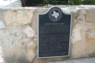
Near San Antonio River Walk, 0.1 miles east of North St. Mary's Street when traveling east.
Many immigrants from both the United States and Europe were attracted to the Republic of Texas after it became independent from Mexico in 1836. Among the new Texans were missionaries of various faiths, including the French Catholic priest Jean . . . — — Map (db m118178) HM
San Antonians had few places to educate their children before 1851 when Catholic Bishop Jean Marie Odin recruited members of the Order of St. Ursula to start a school for girls on the river at the northern edge of town.
The school grew quickly, . . . — — Map (db m118168) HM
On Wyoming Street at South Mittman Street, on the right when traveling east on Wyoming Street.
St. Philip's Industrial School, founded March 1, 1898, was born of strong support from the RT. Rev. James Steptoe Johnston, Bishop of the Episcopal Diocese of West Texas, and the parishioners of St. Philip's Church. The church congregation, seeking . . . — — Map (db m213466) HM
Near East Commerce Street, 0.1 miles east of North Palmetto Street.
Native South Carolinian, pioneer doctor and editor, Republic of Texas Congressman, twice State Senator, Jack Hay's adjutant in War with Mexico, fearless Ranger Captain in border and Indian campaigns, Confederate colonel, Mayor of Austin and . . . — — Map (db m163782) HM
On SW 24th Street at West César E. Chávez, on the right when traveling south on SW 24th Street.
The heritage of this Catholic University reflects the early educational efforts of Jean Martin Moye, an 18th-century French educator, and American bishops at the 1866 Council of Baltimore. In order to carry out the council's mandates, Bishop Dubois . . . — — Map (db m202221) HM
On Villita Street at King Philip Alley, on the left when traveling west on Villita Street.
Opening at this site in 1898 as "St. Philip's Saturday evening sewing class for black girls", this college was found by the Rt. Rev. James Steptoe Johnston (1843-1924), Episcopal Bishop of western Texas, who considered education a tool toward . . . — — Map (db m82879) HM
On King Philip Alley south of Villita Street, on the left when traveling south.
St. Philip‘s College was begun in an adobe house just north of this building in 1898. Originally a parochial day school, it grew into a grammar and industrial school with a boarding department. This two-story brick building was constructed by the . . . — — Map (db m82898) HM
On South Alamo Street south of East Nueva Street, on the right when traveling south.
Erected as a school for children of German settlers, these historic buildings have served numerous educational and cultural purposes:
1858 – German–English school founded by "The Lateiner”, a group of German intellectuals. . . . — — Map (db m82882) HM
The Ruiz House, built around 1745 originally stood at what is now 420 Dolorosa Street facing north on Military Plaza. It was occupied in about 1760 by a tailor, Juan Manuel Ruiz, who had come to San Antonio from Spain. José Francisco Ruiz, for whom . . . — — Map (db m239099) HM
On W. Houston St. at N. Flores St., on the right when traveling west on W. Houston St..
(monument text) (1833-1903) Educator Attorney Public Servant Soldier Merchant Banker (plaque text): Thomas Claiborne Frost (1833 – 1903)
Born in Jackson County, Alabama in 1833, T. C. Frost graduated from Irving College . . . — — Map (db m63694) HM WM
On Commerce Street at Main Plaza, on the left when traveling west on Commerce Street.
Thomas Claiborne Frost (1833-1903) came to Texas from Alabama in 1855 to teach at Austin College, Huntsville. Admitted to the Bar in 1856, he served as a Texas Ranger before setting up a law practice in Comanche County. He was a delegate to the . . . — — Map (db m30223) HM
On Dolorosa Street, 0.1 miles east of South Laredo Street, on the right when traveling east.
In the Early 1960s government agencies determined that neighborhoods along and near San Pedro Creek, including Laredito, were so deteriorated that they were eligible for acquisition, clearance, and redevelopment under the federal Urban Renewal . . . — — Map (db m214577) HM
On North Saint Mary's Street at Tuleta Drive, on the right when traveling north on North Saint Mary's Street.
City Parks Commissioner Ludwig Mahncke displayed a collection of buffalo, elk, deer, lions, and bears in an enclosed area near the south end of Brackenridge Park in the early 1900s. Prior to that time, San Antonians viewed animals at a small . . . — — Map (db m214843) HM
On West Huisache Avenue at Howard Street, on the right when traveling west on West Huisache Avenue.
In early 1907, residents of the Laurel Heights area petitioned the Sisters of the Divine Providence, a French religious order to open a neighborhood school. The order already operated four local schools and many more throughout Texas and adjoining . . . — — Map (db m213325) HM
Near Wyoming Street just east of South Palmetto Street, on the right when traveling east.
Teacher, historian and preservationist Adina Emilia de Zavala was born in Harris County, Texas, on November 28, 1861. She was the daughter of Augustine and Julia Tyrrell de Zavala, and the granddaughter of Lorenzo de Zavala, first Vice-President of . . . — — Map (db m163739) HM
On De Zavala Road at Syracuse Street, on the right when traveling east on De Zavala Road.
One of Texas' oldest public schools; operated continuously since 1868. Named in honor of Wm. J. Locke, who donated land. Originally school was held in a supply depot (1 mi. SW). School was named "Shavano" for some years. The present . . . — — Map (db m176039) HM
On East Evans Road, 0.1 miles east of Nacogdoches Road, on the right when traveling east.
William Davenport was born in 1820 in Saltville township, Virginia. His family later lived in Kentucky before settling in present-day Kaufman County, Texas in 1843. There William met and married Mary Ware, daughter of Texas Revolutionary veteran . . . — — Map (db m195451) HM
The Texas A&M University-San Antonio Campus was built on land that once was conveyed by Spanish and Mexican land grants and traversed by several branches of El Camino Real de Tierra Afuera del Oriente (also known as El Camino Real de los Tejas . . . — — Map (db m98241) HM
On St. Mary's University, 0.1 miles north of Rattler Drive.
In 1852, four brothers of Mary - three from France, one from Ohio - established the early beginnings of St. Mary's University and Central Catholic High School, at 112 College Street, San Antonio, Bexar County, Texas.
This sturdy stone rests . . . — — Map (db m238289) HM
On St. Mary's University, 0.1 miles north of Rattler Drive, on the left.
Donated by the Class of 2000 and Weldon M, Jacobs, 1938 graduate
The rattlesnake mascot was adopted in the 1920s when, as the story goes, diamondback rattlesnakes were routinely found on University grounds. The "Rattler" subsequently was . . . — — Map (db m238299) HM
On Camino Santa Maria Street at Cincinnati Avenue on Camino Santa Maria Street.
St. Mary's University has served the educational needs of residents in San Antonio and throughout Texas since the mid-1800s. In 1851, the Rev. Jean-Marie Odin, Vicar Apostolic and later Bishop of Galveston, traveled to France to recruit clergy to . . . — — Map (db m238300) HM
On Broadway at East Hildebrand Avenue on Broadway.
In 1897, the Sisters purchased the 283 acre Fernridge estate from Colonel George W. Brackenridge as the site for a new Motherhouse for the growing Congregation.
The house was renamed the Brackenridge Villa by the Sisters. After 3 years as the . . . — — Map (db m214713) HM
Until the mid-1980's, the Sisters' land west of the San Antonio River was a natural, wooded area, with many headwaters springs. Sisters recall walking through a "wilderness" and seeing springs bubbling up from the ground.
A small dam downstream . . . — — Map (db m214709) HM
Established by the Sisters in 2008, the Headwaters Sanctuary preserves 53 acres of spring-filled land, including the San Antonio Spring or "Blue Hole." The Sisters dedicated this area to conservation as an expression of their commitment to care for . . . — — Map (db m214717) HM
Noted for quality educational programs, this institution grew from a teaching charter granted in 1881 to the Sisters of Charity of the Incarnate Word. In 1893 a boarding and day school known as Incarnate Word Academy was established. By 1909 a . . . — — Map (db m207839) HM
On Broadway at East Hildebrand Avenue on Broadway.
Built in 1904 by Fr. J.G. Bednarek of Chicago, the Grotto marked the 50th anniversary of the promulgation of the dogma of the Immaculate Conception of the Blessed Virgin Mary. It is a replica of the grotto of Our Lady of Lourdes in France. . . . — — Map (db m214711) HM
The 1900 Motherhouse of the Sisters of Charity of the Incarnate Word was designed by architect Alfred Giles to house the convent, novitiate, and College and Academy of the Incarnate Word. Here, the Sisters lived, prayed and worked. It was the home . . . — — Map (db m214704) HM
On Broadway at East Hildebrand Avenue on Broadway.
The Chapel of the Incarnate Word was dedicated on May 30, 1907. The Romanesque design by architect F.D. Gaenslen features outstanding stained glass windows created by the Emil Frei studios in St. Louis, Missouri. A place of prayer and celebration, . . . — — Map (db m214707) HM
The San Antonio Spring, or Blue Hole, is the mainspring in a field of many artesian springs which arise from the Edwards Aquifer and form the headwaters of the San Antonio River.
Known as Yanaguana, meaning Spirit Waters, this spring was once a . . . — — Map (db m214716) HM
On Augusta Street at Giraud Street, on the left when traveling south on Augusta Street.
The original complex of eight buildings was erected 1851-1882. Main building is largest known Texas structure in French "Pise de Terre" (Rammed Earth) method.
Upon their arrival here in 1851 the Ursuline Nuns found the abandoned, decaying . . . — — Map (db m213516) HM
On West Ashby Place at Wilson Boulevard, on the left when traveling east on West Ashby Place.
Erected as a two-story home in 1890, this structure was the original building of Peacock School for Boys, founded in 1894 by Wesley Peacock (1865-1941). Military training was initiated in 1900. Chartered in 1904, it became a distinguished school . . . — — Map (db m176058) HM
On 11th Street at Mesquite Street, on the right when traveling west on 11th Street.
Chartered in 1883, Blanco High School began as a combination private and public school. A white limestone schoolhouse was constructed at this site and opened for classes in October 1884. During its early years, Blanco High School offered a six-month . . . — — Map (db m194073) HM
On Main Street (U.S. 281), on the left when traveling south.
Designed in Victorian style by architect F. E. Ruffini. Erected in 1886 as first permanent county courthouse, building served only four years - until 1890. County seat then moved to Johnson City.
Purchased by Chas. E. Crist, the structure . . . — — Map (db m31565) HM
On Avenue F at Main Street (U.S. 290), on the right when traveling north on Avenue F.
In 1879, on July 19-20 or August 16-17, seven members formed the Missionary Baptist Church of Christ, present First Baptist Church. The Rev. James E. Bell (b.1843) held services in the schoolhouse. Lumber for the original church building, erected . . . — — Map (db m31532) HM
On Elm Street at Avenue G, on the right when traveling east on Elm Street.
Sam Ealy Johnson Jr. (1877-1937) and his wife Rebekah Baines Johnson (1881-1958) bought this residence in 1913. Sam, an educator and six-term Texas legislator, and Rebekah, an educator and journalist, raised five children here. The frame house was . . . — — Map (db m30926) HM
On Avenue G at Ladybird Lane, on the right when traveling north on Avenue G.
Lyndon Johnson spent most of ten years living in this home - a decade that profoundly affected the future president's view of the world.
A neat landscape in front of you bears little resemblance to the backyard Lyndon Johnson knew. In Johnson's . . . — — Map (db m31036) HM
On South College Hill Drive at West 9th Street on South College Hill Drive.
Constructed in 1923 as the administration building for the Lutheran College of Clifton, this structure served students and faculty until 1954, when the school merged with Texas Lutheran College in Seguin. The building was sold in 1954 and housed the . . . — — Map (db m233814) HM
On South Avenue Q at West 9th Street, on the left when traveling north on South Avenue Q.
Organized May 6, 1896. Located on land donated by N.J. Nelson and T.T. Hogevold. The first building, erected with voluntary donations and labor, opened as high school Oct. 28, 1897; after 1923 housed artifacts collection of Jacob Olson, early . . . — — Map (db m233721) HM
On State Highway 174 near Creek 2850, on the right when traveling north.
Started before 1879, the Union Hill School was one of several rural schools that served the early settlers of Bosque County. A two-room 1888 schoolhouse, located across the road, was used until 1914, when a two-story building was constructed at this . . . — — Map (db m194308) HM
On Farm to Market Road 56, 0.2 miles east of County Highway 2490, on the left when traveling west.
The Coon Creek community evolved from the Old Cyrus community, the oldest settlement in southeastern Bosque County. The first settler was Temple Spivey who purchased land on the Brazos River in 1853. In January 1856, John Jackson Smith purchased . . . — — Map (db m161798) HM
On North Chenango Street at East Locust Street, on the right when traveling north on North Chenango Street.
On September 5, 1892, two Angleton residents donated one of the original town blocks near this site to the city for school purposes. Citizens contributed two hundred dollars for a frame building to house the first classes for Angleton students and . . . — — Map (db m129301) HM
On Front Street (County Route 300B) at Austin Street (Route 300E), on the left when traveling east on Front Street.
During a brief and troubled time in her life, Carry Amelia Moore Nation (1846-1911) operated the "Old Columbia Hotel" on this site about 1880. She later achieved fame as a hatchet-wielding crusader against the use of alcoholic drink and tobacco. . . . — — Map (db m89328) HM
On North Velasco Boulevard (County Road 523) just north of South Avenue H, on the right when traveling north.
In 1947, the various African American communities of the recently organized Brazosport Independent School District were consolidated at Velasco. Children from Freeport, Jones Creek, Clute and Evergreen gathered together in one building. For . . . — — Map (db m244238) HM
On North Grand Boulevard at East Broadway Street (Farm to Market Road 518), on the right when traveling north on North Grand Boulevard.
A terrible storm ravaged Pearland in 1915. Among the important structures it destroyed was the town's high school. For the next 22 years, Pearland teenagers traveled to Webster to attend classes. The long commute severely curtailed their involvement . . . — — Map (db m137329) HM
A grant from the Rosenwald Foundation of Chicago led to the establishment of a local school for African American students. The foundation represented a collaboration between Julius Rosenwald, President of Sears, Roebuck, and Company, and the . . . — — Map (db m83276) HM
Near East Jackson Street east of South 16th Street, on the right when traveling east.
New Yorker George Rounds served in Col. James W. Fannin's regiment in the Texas War for Independence but escaped the Goliad Massacre. He settled in Columbia, where he operated a tavern. Just before his death, he drew up a will devising his estate . . . — — Map (db m173039) HM
On East Pruitt Street at North Preston Avenue, on the right when traveling west on East Pruitt Street.
On March 30, 1885, the City of Bryan purchased seven lots in this area as a site for a public school to provide separate but equal and impartial instruction for black children of the community, as prescribed by the Texas State Constitution of 1876. . . . — — Map (db m187778) HM
Near Boonville Road, 0.1 miles east of Austins Colony Parkway.
"Welcome to My Town"
Father of Brazos County
Harvey Mitchell was born in 1821 in Tennessee. Because his parents could not afford to send him to college, the ambitious 18 year old came to Texas in 1838. From 1839 to 1842, . . . — — Map (db m170405) HM
On East 26th Street west of North Texas Avenue (Local Road 68), on the right when traveling west.
Came to Texas from Tennessee in 1839, and joined "minute men" protecting north frontier from Trinity to Brazos River. Moved to Brazos County; served 1842-1853 in County offices: Deputy Clerk, County Clerk, Surveyor, Chief Justice. Taught school, . . . — — Map (db m119644) HM
On Jones Road at Leonard Road, on the right when traveling north on Jones Road.
In the late 1890s, Sam Luther donated the land at this site for a school. At the time, most residents of the Leonard community were Polish, German and Czech immigrants who were drawn to the area by the Brazos River’s rich soil. The Leonard School . . . — — Map (db m233731) HM
On Osborn Lane at Ursuline Avenue, on the right when traveling east on Osborn Lane.
The Ursuline Sisters, founded by St. Angela in Italy in 1535, opened their first girls' school in North America in Quebec in 1639. In 1727, they opened the Ursuline Academy in New Orleans, followed in 1847 with the Ursuline Academy in Galveston. . . . — — Map (db m179149) HM
On North Preston Avenue at William Joel Bryan Parkway (Farm to Market Road 158), on the right when traveling north on North Preston Avenue.
The Rev. Joseph Pelnar of Bryan's St. Joseph Catholic Church erected a parish school building here in the early 1890s. The children of East European immigrant families dominated student enrollment at St. Joseph's until about the 1930s. Teachers . . . — — Map (db m170271) HM
Immediately after the end of World War II, The Agricultural and Mechanical College of Texas faced a severe housing and classroom space shortage because of the groundswell of returning veterans. Starting in 1946, facilities were leased at Bryan Army . . . — — Map (db m233810) HM
Near Boonville Road, 0.1 miles east of Austins Colony Parkway.
The Boonville School Play Yard likely was associated with the school conducted in the courthouse building but may have also been used by the school in the nearby Masonic Lodge building. Nineteenth century playgrounds were located in open spaces . . . — — Map (db m174273) HM
On Boonville Road (Farm to Market Road 158) 0.1 miles east of Austins Colony Parkway, on the left when traveling east.
Granddaughter of Harvey Mitchell, a pioneer settler of Brazos County, Wesa Weddington began teaching Latin and Spanish in 1903 in Bryan public schools. She received a Masters Degree in 1918 from Columbia University and then taught while serving as . . . — — Map (db m201994) HM
On Welsh Avenue, 0.2 miles north of Harvey Mitchell Parkway South (Farm to Market Road 2818).
The State of Texas granted a charter for an independent school district to encompass the Texas A&M College campus in 1909. Because there was not a sufficient number of students in the district to support a school, A&M president William Bizzell and . . . — — Map (db m170201) HM
The Academic Building (1914) was designed by campus architect Frederick E. Giesecke, '86 and Samuel E. Gideon, after Old Main was destroyed by fire in 1912. The beaux-arts classical design is a four-storied reinforced concrete structure faced with . . . — — Map (db m120269) HM
On Eleanor Street at Holleman Drive, on the left when traveling north on Eleanor Street.
Formal education for African Americans in Brazos County began as a result of the Public School Act of 1871. Classes were held in many small community and church-related schools, and by 1923 there were 127 African American students in the A&M . . . — — Map (db m170204) HM
The Chemistry Building (1929) was designed by S. C. P. Vosper, using classical design proportions and details. It was extended to the east in 1981 and 1988. The ornamentation uses a variety of color schemes in tile patterns inspired from the art of . . . — — Map (db m120273) HM
On Throckmorton Street, on the right when traveling south.
When Texas A&M University opened in 1876, it was four miles from Bryan, the nearest town, and the need for campus housing for faculty and staff arose. The first of the campus houses, five brick homes along the east side of Throckmorton Street, were . . . — — Map (db m119625) HM
Rolland Adelsperger, College Architect and Professor of Architecture and Architectural Engineering designed Francis Hall in a highly distinctive romanesque style in 1913 for the
School of Veterinary Medicine. The proposed design exceeded the . . . — — Map (db m120274) HM
The History Building was erected in 1922 as the Agriculture Building and housed the Dean of Agriculture for about ten years. Architect E. B. La Roche used a classical revival style with a strong base, rusticated brick main floor, and two-story . . . — — Map (db m120275) HM
Built in 1911, Legett Hall is the oldest residence hall on campus and one of two remaining along Military Walk. Named for Judge Kirvin Kade Legett (1857-1926) of Abilene, President of the Agricultural and Mechanical College of Texas Board of . . . — — Map (db m120270) HM
Texas A&M University opened in October 1876 and established the Corps of Cadets to fulfill its Congressional mandate to teach military tactics. The students at what was then an all-male institution were required to serve in the corps and follow . . . — — Map (db m119627) HM
Nagle Hall is one of the oldest buildings on campus, constructed in 1909 as the Civil Engineering building. Renamed in 1929 for James C. Nagle, the first dean of the School of Engineering. The design maintains the campus' distinct classical . . . — — Map (db m120268) HM
On Scott and White Drive, 0.1 miles south of Rock Prairie Road, on the right when traveling north.
German immigrant Adam Royder (d. 1894) donated one acre of land here for school purposes in 1891. A one-room schoolhouse was constructed where area students received instruction through the seventh grade. The Rock Prairie Missionary Baptist Church . . . — — Map (db m168058) HM
Sbisa Dining Hall (1913) was designed by campus architect Frederick E. Giesecke to replace the castle-like 1897 mess hall that burned in 1911. It anchors the north end of Military Walk whose south terminus was Guion Assembly Hall (1918-1971). A . . . — — Map (db m120271) HM
On Houston Street near Old Main Drive, in the median.
Silver Taps, held the first Tuesday of every month is that final tribute paid to an Aggie who, at the time of his or her death, was enrolled at Texas A&M.
On the day of Silver Taps, the flag in front of the Academic building is flown at . . . — — Map (db m238302) HM
Soon after its opening in 1876, the Agricultural and Mechanical College of Texas (Texas A&M) established the Corps of Cadets to fulfill its mandate to instruct its students (all-male until the early 1960s) in military science. A&M contributed more . . . — — Map (db m119628) HM
On New Main Drive at South Texas Avenue (Business State Highway 6), on the right when traveling west on New Main Drive.
The State Legislature authorized the Agricultural and Mechanical College of Texas April 17, 1871, under terms of the Federal Morrill Act. Constitutionally a part of a chartered, yet-unorganized state university, A&M gained its own directorate in . . . — — Map (db m119592) HM
World War I allowed the Agricultural and Mechanical College of Texas to expand beyond military training and directly contribute to the war effort with staff and students volunteering for service in large numbers. Students first served for other . . . — — Map (db m126521) HM
The Williams Building (1932) was designed by architect S. C. P. Vosper in a classical revival
style as the headquarters for the Texas A&M System. The building faced the new state highway symbolizing the shift from train to automobile travel. The . . . — — Map (db m120276) HM
On University Drive at Tauber Street, on the left when traveling north on University Drive.
In 1918–19, Texas A&M President W.B. Bizzell asked ministers of Bryan churches to provide religious services for students of their respective denominations. In response, Rev. P.T. Ramsey of First Methodist Church provided $500 and encouraged . . . — — Map (db m238739) HM
In 1917, while a student at the Agricultural and Mechanical College of Texas, James Vernon “Pinky” Wilson ’20 enlisted in the United States Marine Corps to join WWI. While Stationed in the foxholes and trenches of France, he composed the words . . . — — Map (db m221431) HM WM
On North Harrison Street, on the right when traveling north.
Iowa born family came to Texas 1839. Gained experience with Indians in central Texas while father was Indian agent. Led reservation Indians in campaigns against Comanches. As Ranger company captain in 1855 he killed the noted Comanche Chief Peta . . . — — Map (db m50296) HM
This adobe house was built in 1925 as the residence of Fred Garlick, farm manager for Wayne Cartledge's La Harmonia Company. During the 1930s, it also served as a schoolhouse for the children who lived in this remote area. The Garlick House is among . . . — — Map (db m219259) HM
On Highway 378, on the right when traveling south.
Francis School (Common School District No. 3) organized in 1898 for citizens of southwest Briscoe County. The school was named for J.L. Francis, who offered his land and took on much of the building expenses. Around 1915, the school was moved to a . . . — — Map (db m150752) HM
On Farm to Market Road 378, on the left when traveling south.
In 1913, G.C. Holt moved his wife and eight children to the Briscoe-Floyd county line. Because of the distance to the nearest school, Holt and neighbor E.M. Lawson organized the Holt school district, commissioned on September 7, 1920 with two . . . — — Map (db m150753) HM
On Center Avenue at Austin Avenue, on the right when traveling north on Center Avenue.
The Pecan Valley Baptist Association was formed by representatives of Baptist congregations in this area in September 1876. Meeting at Indian Creek in June 1889, the association acted on an executive committee resolution calling for the creation of . . . — — Map (db m220749) HM
On Center Avenue at Austin Avenue, on the right when traveling north on Center Avenue.
Founder of Howard Payne University, John David Robnett (1845-1898) was born in Missouri, where he was educated at Westminster and William Jewell colleges and was ordained to the Baptist ministry.
In 1883, Robnett was called to serve as pastor . . . — — Map (db m220766) HM
On Presidential Corridor E (State Highway 21) at County Highway 216, on the right when traveling west on Presidential Corridor E.
Noted pioneer leader. Member Virginia House of Delegates (1844-45). Piloted to Texas (1854) a mile-long wagon train of 200 people, who built Salem Baptist Church - reminder of their Virginia home.
Broaddus debated the Hon. Sam Houston at . . . — — Map (db m125652) HM
On County Highway 271, 0.5 miles north of Farm to Market Road 60, on the right when traveling north.
Prussian born Johann Joachim Giesenschlag (1817-80), his wife Anna (Schulze), and their children came to Texas in 1855. Settling first in Washington County, they moved to Burleson County in the 1870s and bought over 1,000 acres here. Giesenschlag . . . — — Map (db m220041) HM
On 8th Street at Avenue L, on the right when traveling south on 8th Street.
As the Somerville Independent School District (SISD) emerged from the great depression, the school board filed a Works Progress Administration project proposal on October 3, 1938, to build a gymnasium. The proposal was accepted and construction on . . . — — Map (db m203941) HM
When Bertram was founded in 1882 along the Austin & Northwestern Railroad, one of the first structures erected was a combination school, Sunday School, and Masonic Lodge hall. Rudolph Bertram, Austin Railroad executive for whom the town was named, . . . — — Map (db m27427) HM
On State Highway 29 at Farm to Market Road 1174, on the right when traveling west on State Highway 29.
Pinky Wilson is the author of the Aggie War Hymn, the most famous fight song in the world. Pinky was born in 1897 in Florence, TX. He ranched there through 1950, when he purchased a ranch near Bertram, Burnet County TX, where he, wife Erma, and son . . . — — Map (db m203265) HM
On County Road 330, 2.5 miles west of County Road 243, on the right when traveling west.
In 1883, Mount Blanc School organized out of the Oatmeal School System. J. J. McGlothin deeded land for the school site and served with S. H. Campbell and J. T. Chamberlain as the original trustees. Several members of the Chamberlain family taught . . . — — Map (db m201830) HM
Jacob Wolf (1812-1874) and wife Adeline Faulkner Wolf (1814-1870) came from Tennessee to Texas about 1850. Obtaining land grant in Burnet County, they settled at Dobyville, and were pioneers, supplying their own provisions, buildings, medicines, and . . . — — Map (db m27738) HM
One of "Old 300" of Stephen F. Austin's first colony from Pennsylvania, took part in 1836 War for Texas Independence, he made and lost several stakes.
In 1851 bought a league and labor of Burnet County land, including site of Fort Croghan. . . . — — Map (db m29150) HM
On North Pierce Street south of East Johnson Street, on the right when traveling north.
The red brick school was built on property bequeathed by early Burnet County pioneer Peter Kerr. Kerr migrated to what would become Burnet County in 1849. Active in the land and cattle business, he laid out the town of Hamilton, later renamed . . . — — Map (db m140238) HM
On Broadway St., on the right when traveling west.
Adam R. Johnson donated land at this site for construction of the present two-story granite building. Completed in 1891, it originally housed the Marble Falls Alliance University. Near Backbone Creek, east of this main building, a wooden boarding . . . — — Map (db m27600) HM
Near Oatmeal Cemetery Road, 0.1 miles east of CR-243.
This building, once a combined school and church, was erected in 1869 in Oatmeal, second oldest community in Burnet County. The settlement, founded in 1849, had a post office from 1853 to 1876.
This limestone structure was successor to the first . . . — — Map (db m27692) HM
On South Colorado Street at Rosewood Street, on the right when traveling south on South Colorado Street.
Pioneer Lockhart physician, from Alabama. Studied medicine, University of Pennsylvania.
Was Civil War surgeon, Texas Mounted Rifles and Cavalry, on Texas frontier and in Louisiana, Arkansas and Indian Territory.
Typical of Texas . . . — — Map (db m195675) HM
On East Market Street at Carver Street, on the right when traveling east on East Market Street.
According to local tradition, materials salvaged from Ross Institute, a former school for Lockhart's caucasian children, were used in 1923 to build this school for African American students. The Rosenwald Foundation of Chicago, which funded many . . . — — Map (db m180765) HM
On West Newton Street at Texas Avenue, on the right when traveling west on West Newton Street.
Julius Rosenwald created the Rosenwald Fund in 1917 to endow new African American schools. Luling's Rosenwald school opened in 1925 to replace the Luling Colored School which began operation in 1874. The Rosenwald School employed four teachers for . . . — — Map (db m204666) HM
On Alice Wilkins Avenue at South Ann Street, on the right when traveling south on Alice Wilkins Avenue.
Early education for African American students in Port Lavaca dates from the late nineteenth century and a one-room school run by James Choice. The Rev. A.K. Black, a Baptist pastor, later led the school, which included grades 1 to 5 and was located . . . — — Map (db m182150) HM
On Alice Wilkins Avenue at Ann Street, on the left when traveling west on Alice Wilkins Avenue.
When desegregation began in Calhoun County in 1955, many African American students made educational and cultural adjustments. The summer before the 1955-56 school year, long-time educator Naomi B. Chase took a group of students from the all Black . . . — — Map (db m182154) HM
On County Road 471, 0.4 miles east of County Road 483, on the right when traveling east.
Early college of west Texas. Founded in 1881 by Methodist Church. Enrollment reached peak of 300 and students attended from throughout the region.
College developed a superior course of study with special strength in music. It had an orchestra . . . — — Map (db m79093) HM
1254 entries matched your criteria. Entries 101 through 200 are listed above. ⊲ Previous 100 — Next 100 ⊳