By Cosmos Mariner, July 14, 2018
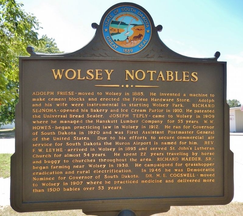
Wolsey Notables (marker side 2)
| On Commercial Avenue (U.S. 14) south of Cardinal Street, on the left when traveling south. |
| On Main Avenue at Front Street, on the right when traveling south on Main Avenue. |
| On Rondell Avenue just east of 2nd Street, on the left when traveling east. |
| On Gaver Rd., 1 mile east of Helmer Rd., on the left when traveling east. |
| Near 5th Avenue (U.S. 85/212) just north of Faulk Street, on the right when traveling north. |
| On East Main Street, 1 mile south of State Route 50, on the right when traveling west. |
| On Main Street south of 2nd Street, on the right when traveling south. |
| On East Kemp Avenue east of North Maple, on the right when traveling east. |
| Near Broadway Street North, 0.1 miles north of 1st Avenue North, on the right when traveling north. |
| On East Kemp Avenue west of South Maple, on the left when traveling west. |
| On U.S. 12 at State Highway 1806 on U.S. 12. |
| Near U.S. 16A east of Lower French Creek Road, on the right when traveling east. |
| On Mount Rushmore Road (U.S. 16A) east of South 4th Street, on the right when traveling east. |
| On Mount Rushmore Road (U.S. 16A) 0.3 miles east of State Highway 89, on the right when traveling east. |
| Near U.S. 16A east of Lower French Creek Road, on the right when traveling east. |
| On Hearst Memorial Highway (U.S. 385) at Avenue of the Chiefs, on the right when traveling north on Hearst Memorial Highway. |
| On South Dakota Route 20, 0.3 miles south of County Road 3, on the right when traveling south. |
| On West Main Street west of Wilson Street, on the right when traveling west. |
| On 2nd Avenue (State Highway 471) north of G Street, on the right when traveling north. |
| On North River Street (U.S. 385) at Minnekahta Avenue, on the right when traveling south on North River Street. |
| On Main Street west of Bridge Street, on the right when traveling west. |
| On East Oak Street at South Center Avenue, on the right when traveling east on East Oak Street. |
| On East 5th Street east of North Broadway (U.S. 14), on the right when traveling west. |
| On Theodore Roosevelt Expressway (U.S. 85) 0.2 miles south of Main Street, on the right when traveling south. |
| On 198th Street (U.S. 14) 0.1 miles west of Runge Road, on the right when traveling east. |
| On State Highway 1804, 1.7 miles west of Grey Goose Rd. |
| On South Pierre Street south of East Capitol Avenue, on the left when traveling south. |
| On South Dakota Route 1804, 0.2 miles north of Range Road, on the right when traveling north. |
| On West Oak Street at West Broadway Ave, on the left when traveling west on West Oak Street. |
| On South Pierre Street south of East Dakota Avenue, on the left when traveling south. |
| On State Highway 34 at milepost 233 at Chapelle Road, on the left on State Highway 34. |
| On 2nd Street Southwest, 0.1 miles west of Dakota Avenue, on the right when traveling west. |
| Near W Main St at Dakota Ave S. |
| On Calumet Avenue Southeast south of 2nd Street Southwest, on the right when traveling south. |
| On Calumet Avenue Southeast north of 2nd Street Southeast, on the right when traveling north. |
| On Calumet Avenue SE at 2nd Street SW, on the right when traveling south on Calumet Avenue SE. |
| On Calumet Avenue Southeast at 3rd Street Southeast, on the right when traveling north on Calumet Avenue Southeast. |
| On Calumet Avenue Southeast at 3rd Street Southwest, on the right when traveling south on Calumet Avenue Southeast. |
| On Calumet Avenue Southeast south of 2nd Street Southwest, on the right when traveling south. |
| On Calumet Avenue Southeast south of 2nd Street Southwest, on the right when traveling south. |
| On Calumet Avenue Southeast south of 2nd Street Southwest, on the right when traveling south. |
| On Calumet Avenue SE at 2nd Street SE, on the left when traveling south on Calumet Avenue SE. |
| On Deadwood Mount Drive south of Pine Street, on the right when traveling south. |
| On Main Street at Deadwood Street, on the right when traveling south on Main Street. |
| On Deadwood Mount Drive south of Pine Street, on the right when traveling south. |
| On Broadway Avenue at Lee Street, on the left when traveling north on Broadway Avenue. |
| Near Charles Street (CanAm Highway) (U.S. 85) at Cedar Lane, on the right when traveling south. |
| Near Mount Roosevelt Road west of Stage Run Road. |
| Near Charles Street (CanAm Highway) (U.S. 85) at Cedar Lane, on the right when traveling south. |
| On Main Street, 0.1 miles south of CanAm Highway (U.S. 85), on the left when traveling north. |
| On Lee Street at Main Street, on the right when traveling west on Lee Street. |
| On Main Street at Pine Street, on the left when traveling south on Main Street. |
| On Wall Street just west of Main Street, on the left when traveling west. |
| On Main Street at Violin Street, on the right when traveling south on Main Street. |
| On Crescent Drive at 76th Drive, on the left when traveling south on Crescent Drive. |
| On Sherman Street (U.S. 85) at Center Street, on the right when traveling south on Sherman Street. |
| On Broadway at Lee Street, on the left when traveling north on Broadway. |
| On Deadwood Mount Drive south of Pine Street, on the left when traveling south. Reported permanently removed. |
| Near Charles Street (CanAm Highway) (U.S. 85) at Cedar Lane, on the right when traveling south. |
| On Main Street at Wall Street, on the right when traveling south on Main Street. |
| Near Charles Street (CanAm Highway) (U.S. 85) at Cedar Lane, on the right when traveling south. |
| Near Mount Roosevelt Road east of Stage Run Road. |
| Near Charles Street (CanAm Highway) (U.S. 85) at Stewart Street, on the right when traveling south. |
| On Main Street (U.S. 85) south of 76th Drive, on the right when traveling south. |
| On Pine Street west of Sherman Street (CanAm Highway), on the right when traveling east. |
| Near Charles Street (CanAm Highway) (U.S. 85) at Cedar Lane, on the right when traveling south. |
| On Deadwood Mount Dr. at Pine Steet on Deadwood Mount Dr.. |
| On U.S. 14 at Blacktail Road, on the right when traveling west on U.S. 14. |
| On Main Street, 0.1 miles west of Deadwood Street, on the left when traveling west. |
| On Deadwood Street at Siever Street, on the right when traveling east on Deadwood Street. |
| Near Charles Street (CanAm Highway) (U.S. 85) at Cedar Lane, on the right when traveling south. |
| On Main Street at Armory Street, on the right when traveling north on Main Street. |
| On Main Street north of Deadwood Street, on the right when traveling north. |
| On Wall Street at Main Street, on the left when traveling west on Wall Street. |
| On Siever Street north of Pine Street, on the left when traveling north. |
| On Mount Roosevelt Road west of Stage Run Road, on the right when traveling west. |
| On West Main Street (CanAm Highway) (U.S. 85) east of Siever Street, on the left when traveling east. |
| Near West Main Street (CanAm Highway) (U.S. 85) east of Stone Street, on the right when traveling east. |
| Near West Main Street (CanAm Highway) (U.S. 85) east of Siever Street, on the left when traveling east. |
| On West Main Street (CanAm Highway) (U.S. 85) east of Stone Street, on the right when traveling east. |
| On West Main Street at Siever Street, on the right when traveling east on West Main Street. |
| On West Main Street (CanAm Highway) (U.S. 85) east of Siever Street, on the left when traveling east. |
| On West Main Street (CanAm Highway) (U.S. 85) west of Julius Street, on the right when traveling west. |
| On West Main Street (CanAm Highway) (U.S. 85) at Siever Street, on the left when traveling east on West Main Street (CanAm Highway). |
| On West Main Street (CanAm Highway) (U.S. 85) east of Siever Street, on the left when traveling east. |
| Near West Main Street (U.S. 85) at Bleeker Street, on the left when traveling east. |
| On West Main Street (CanAm Highway) (U.S. 85) at Siever Street, on the left when traveling east on West Main Street (CanAm Highway). |
| Near West Main Street (CanAm Highway) (Route 85) east of Stone Street, on the right when traveling east. |
| On West Main Street (CanAm Highway) (U.S. 85) east of Stone Street, on the right when traveling east. |
| On West Main Street (CanAm Highway) (Route 85) east of Stone Street, on the right when traveling east. |
| On West Main Street (CanAm Highway) (U.S. 85) east of Stone Street, on the right when traveling east. |
| On West Main Street (CanAm Highway) (U.S. 85) west of Julius Street, on the right when traveling west. |
| On West Main Street (CanAm Highway) (Highway 85) east of Stone Street, on the right when traveling east. |
| On West Main Street (CanAm Highway) (U.S. 85) east of Siever Street, on the left when traveling east. |
| On Glendale Drive west of Main Street (CanAm Highway) (U.S. 85), on the right when traveling east. |
| On West Main Street (U.S. 85) at Bleeker Street, on the left when traveling east on West Main Street. |
| On West Main Street (U.S. 85) at Bleeker Street, on the left on West Main Street. |
| On West Main Street / CanAm Highway (U.S. 85) east of Paul Street, on the right when traveling north. |
| On CanAm Highway (U.S. 85) north of U.S. 385, on the left when traveling north. |
| On CanAm Highway (U.S. 85) north of U.S. 385, on the left when traveling north. |
185 entries matched your criteria. The first 100 are listed above.
The final 85 ⊳