[Center and Main Marker:]
This plaque marks the terminus of the First Transcontinental Passenger train that started in New York City and terminated at Alameda Point Pier on September 6, 1869. Erected by the U.S. Naval Air . . . — — Map (db m150959) HM
Pan American World Airways fabled China Clipper (Martin M/130 Flying Boat) left Alameda Marina on November 22, 1935. Under the command of Captain Edwin G. Musick. The flight would reach Manila via Honolulu, Midway, Wake, and Guam. The inauguration . . . — — Map (db m100565) HM
On April 1, 1942, sixteen B-25 bombers were hoisted to the flight deck of the carrier Hornet and parked there, while moored at Pier No. 3 at U.S. Naval Station in Alameda. The B-25 detachment consisted of seventy officers and one hundred thirty . . . — — Map (db m29431) HM
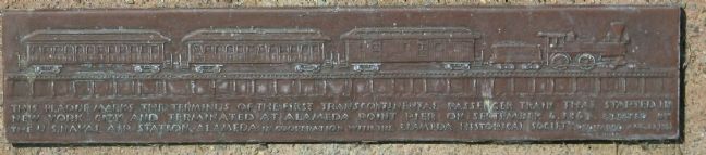
On September 6, 1869 first Transcontinental
Railroad train linking two great oceans, and
consisting of twelve cars and three locomotives
passed here on way to a wharf terminal west
of here, a location now covered by lagoon
for take-off . . . — — Map (db m150265) HM
Piedmont Way was conceived in 1865 by Frederick Law Olmstead, America’s foremost landscape architect, as the centerpiece of a gracious residential community close beside the College of California, Olmstead envisioned a roadway that would follow the . . . — — Map (db m229320) HM
The Berkeley City Club, organized in 1927, was one of the area’s earliest attempts by women to social, civic and cultural progress. The building, constructed in 1929, is one of the outstanding works of noted California architect Julia Morgan, . . . — — Map (db m100562) HM
These landmarks form the historic core of the first University of California campus, opened in 1873: Founders’ Rock, University House, Faculty Club and Glade, Hearst Greek Theatre, Hearst Memorial Mining Building, Doe Library, Sather Tower and . . . — — Map (db m229323) HM
This site was part of the original Don Castro Land Grant. In 1866 pioneer settler Josiah Grover Brickell made a land grant of this site for “educational purposes only” and paid the teacher’s salary, who taught children by day, in a one . . . — — Map (db m100557) HM
In 1877, across the railroad tracks from here, Edward Wiard
built a dance pavilion on top of an ancient shell mound, either
oblivious to, or choosing to ignore, its cultural significance to
the indigenous people. Thus, Shell Mound Park was . . . — — Map (db m239056) HM
At the Ohlone Indian village of Oroysom, Padre Fermín Francisco de Lasuén founded this fourteenth of twenty-one Franciscan missions June 11, 1797. Taught by Padre Narciso Durán, the Ohlone Orchestra and Choir became famous. By 1830 almost 2,000 . . . — — Map (db m100551) HM
Site of flour mill, Niles. Built 1853 by Don Jose De Vallejo, brother of General Vallejo, on his Rancho Arroyo De La Alameda.
Niles was once called "Vallejo Mills". Stone aqueduct carrying water for mill parallels Niles Canyon Road. — — Map (db m154369) HM
This winery was founded in 1869 by Leland Stanford, railroad builder, Governor of California, United States Senator, and founder of Stanford University. The vineyard, planted by his brother Josiah Stanford, helped to prove that wines equal to any in . . . — — Map (db m100554) HM
Along the ridge behind this panel lies a 52-acre parcel of historical significance. This farmstead known as “Ukraina” was the home of Ukrainian patriot, writer, and publisher Father Agapius Honcharenko. He and his wife Albina lived here . . . — — Map (db m26499) HM
“Ukraina” is the site of the farm and burial place of the Ukrainian patriot and exiled orthodox priest Agapius Honcharenko (1832-1916) and his wife Albina. Honcharenko was the first nationally conscious Ukrainian to arrive in the United States. He . . . — — Map (db m146447) HM
Here, in 1883, James Concannon founded the Concannon Vineyard. The quality it achieved in sacramental and commercial wines helped establish Livermore Valley as one of America’s select wine growing districts. Grape cuttings from this vineyard were . . . — — Map (db m100553) HM
Here, Charles A. Wetmore planted his vineyard in 1882. The Cresta Blanca wine he made from its fruit won for California the first international award, the highest honor at the 1889 Paris Exposition, first bringing assurance to California wine . . . — — Map (db m100552) HM
Born in England 1799 – Died Rancho Las Positas 1858. Arrived in Monterey 1822. Married Josefa Higuera y Puentes 1830. Settled on Rancho Las Positas 1835.
“Next to the Mission Fathers, he was the first man to engage himself in the culture of . . . — — Map (db m199846) HM
Here the first Wente Vineyards of 47 acres was established by C.H. Wente in 1883. In 1935 his sons, Ernest and Herman, introduced California’s first varietal wine label, Sauvignon Blanc. The efforts of the Wente family have helped to establish the . . . — — Map (db m100563) HM
The naming of the Rainbow Trout species was based on fish taken from the San Leandro Creek drainage. In 1855, Dr. W.P. Gibbons, founder of the California Academy of Sciences, was given three specimens obtained from the creek. He described and . . . — — Map (db m100566) HM
Until at least 1851, Redwood trees on this site were used as landmarks to avoid striking the treacherous submerged Blossom Rock in San Francisco Bay west of Yerba Buena Island. Although by 1855 the original stems had been logged, today's trees are . . . — — Map (db m100564) HM
Designed in 1889 by Walter J. Mathews, this solid masonry Romanesque church departed radically from California's traditional Gothic wood frame construction. Noted for its world famous stained glass windows produced by Goodhue of Boston, and for . . . — — Map (db m100561) HM
This is a superior rendering of the "Art Deco" or "Moderne" style of movie palace built during the rise of the motion picture industry. The Paramount, which opened on December 16, 1931, is the most ambitious theatre design of architect Timothy L. . . . — — Map (db m100560) HM
University of California, chartered March 23, 1868. Located between Franklin and Harrison, 12th and 14th Streets, from 1869 to 1873, using buildings of former College of California, successor to Contra Costa Academy founded by Henry Durant, June . . . — — Map (db m100544) HM
Built in 1868 by Enoch H. Pardee (1827-96), physician, Mayor of Oakland, State Assemblyman, and Senator, it was the home of the families of E. H. Pardee and his son, George C. Pardee (1857- 1941), physician, Mayor of Oakland, Governor of . . . — — Map (db m71298) HM
This church founded under authority of Bishop Kip, first Episcopal Bishop for California, has given uninterrupted service to this community since
June 27, 1858 — — Map (db m143394) HM
Joaquin Miller, “Poet of the Sierras,” resided on these acres, named by him “The Hights,” from 1886 to 1913. In this building known as The Abbey, he wrote “Columbus” and other poems. The surrounding trees were planted by him and he personally . . . — — Map (db m100546) HM
The first known inhabitants of Fruitvale were the Ohlone. In 1820 the Spanish crown gave this land to Luis Peralta, making Peralta Hacienda the first non-native settlement in Oakland.
From 1820 to 1897, the family had a rancho at this site. . . . — — Map (db m28960) HM
Built in 1854, the Alviso Adobe is one of the few adobe structures remaining in the Bay Area. Declared a California Historic Landmark in 1954, the building stands relatively unmodified since the 1920s.
The adobe was in continuous use from 1854 . . . — — Map (db m24616) HM
First brick house built in Alameda County. Constructed 1860 by W. R. Toler for Ignacio Peralta, early San Leandro Spanish settler, whose father, Don Luis Maria Peralta, received land grant from Spanish Governor Don Pablo Vicente de Sola, October 20, . . . — — Map (db m100550) HM
Governor Pablo de Solá, last Spanish Governor of California, awarded the San Antonio Grant to Don Luis Maria Peralta on August 13, 1820, in recognition of forty years of service. From this point northward the Grant embraced over 43,000 acres. Now . . . — — Map (db m100548) HM
Oysters were the mainstay of the California fishing industry at the turn of the century. Along this site (the original Mulford Canal) the San Leandro oyster beds flourished. In 1892 William Roberts field title to the beds south along San Lorenzo . . . — — Map (db m100559) HM
Site of the last home of José Joaquin Estudillo, grantee of Rancho San Leandro and his wife, Juana Martínez de Estudillo. It was built about 1850. The family founded San Leandro, built a hotel, and donated several lots, including the original site . . . — — Map (db m100549) HM
The first court house where Alameda County government began, June 6, 1853. Officials met in two-story wooden building erected by Henry C. Smith and A. M. Church as merchandise store. Seat of government moved to San Leandro in 1856 following vote of . . . — — Map (db m28910) HM
The factory was built in 1870 by E. H. Dyer, “Father of the American Beet Sugar Industry.” Located on a corner of Dyer’s farm, the small factory began processing sugarbeets on November 15, 1870, and produced 293 tons of sugar during its . . . — — Map (db m100556) HM
This building has been the pioneer home of the Kirkwood and Taylor families since it was built by Zachary Kirkwood in 1864. This building was one of the first resorts operated in the Sierra Nevada Mountains. — — Map (db m100580) HM
On this spot, which marks the summit of the Kit Carson Pass, stood what was known as the Kit Carson Tree on which the famous scout Kit Carson inscribed his name in 1844 when he guided the then Captain John C. Fremont, head of a government exploring . . . — — Map (db m100568) HM
At this point in August 1849, a group of Odd Fellows nearing their goal, the California gold mines, paused in their struggle up these granite walls, to paint on this and adjacent boulders their names and the three links of the Great Order they so . . . — — Map (db m100569) HM
Here the Old Emigrant Road of 1848 swung down across the meadow now covered by Caples Lake (Twin Lakes) and climbed along the ridge at the right to the gap at the head of the valley. From this summit (9,460 feet) it descended to Placerville. This . . . — — Map (db m100570) HM
At this place the highway crosses the site of the old emigrant road which here began a long loop around the Silver Lake basin, taking it to an elevation of 9,640 feet at one place. This difficult portion of the road was used by thousands of . . . — — Map (db m175821) HM
Named after Major John Ebbett and pointed out in 1853 to surveyor G.H. Goodard who referred to it as a “route of great promise – probably the best one for a transcontinental railway.”
No emigrant train used this route but a . . . — — Map (db m11444) HM
On September 12, 1861, Jacob Markley staked out a land claim of 160 acres, a parcel that included this site. Markley erected a 16 by 20 foot log cabin somewhere near this plaque, covering it with shakes made from local Sugar Pine. He also built a . . . — — Map (db m157808) HM
During the initial five weeks of its operation in 1860, an important remount station of the famous Pony Express was located a few feet from here at Cary’s Barn.
This monument erected by the Historical Society of Alpine County.
National . . . — — Map (db m143520) HM
Historic Woodfords Station, the Eastern Sierra gateway to the goldfields of California, way station of the famed Pony Express, and entrance to Carson Pass on the Emigrant Trail to the Sacramento Valley. Beginning in 1849 with the building of the . . . — — Map (db m195369) HM
Founded 1848. Oldest town and first in which gold was discovered in Amador County. Its venerable town hall and other picturesque structures remain. Was not "dry" as name implies, containing 26 saloons at one time. — — Map (db m100575) HM
Settled by Missourians 1849. Suggested that settlement be called Fiddletown because residents “were always fiddling”. Changed in 1878 to Oleta but original name later restored. Once trading center for American, Loafer, and French Flats, . . . — — Map (db m100577) HM
California Historical Landmark
—— Fiddletown-Oleta ——
Settled in 1849 by a party from Missouri. According to tradition they were always fiddling, especially while waiting for the rainy season—hence the name..... It . . . — — Map (db m2539) HM
General merchandise store built by Daniel Stewart in 1856. First brick building erected in Ione Valley from nearby Muletown brick. Ione, once known as "Bed-Bug" and "Freeze-Out” was an important supply center on the main road to the Mother Lode and . . . — — Map (db m100587) HM
In 1848, Mexican Settlers from Sonora, Mexico established a camp on the north back of the Mokelumne River and called it Sonora Bar. At the start of the California Gold Rush miners flocked to the Mokelumne River and set up camps and towns along its . . . — — Map (db m126094) HM
The cornerstone was laid in 1862. Constructed of locally fired brick, the church was completed in 1866. Dedicated as “Ione City Centenary Church” and later popularly known as the “Cathedral of the Mother Lode.” The church was the first to serve the . . . — — Map (db m241817) HM
The “castle,” built in 1890–1894, is the most significant example of Romanesque Revival architecture in the Mother Lode. It was built to house the Preston School of Industry, established by the State Legislature as a progressive . . . — — Map (db m100594) HM
Argonaut Mine, discovered 1850, and Kennedy Mine, discovered 1856, played dramatic roles in the economic development of California. They produced $105,268,760 in gold. Kennedy Mine has a vertical shaft of 5,912 feet, the deepest in the United . . . — — Map (db m100586) HM
Constructed by Italian stone mason in 1857. Served pioneer settlers and miners as post office and general store later later known as Ginocchio's. — — Map (db m100579) HM
The Order or Native Daughters
of the Golden West
was organized on these premises
The site of the
Pioneer Hall
on September 1, 1886.
This tablet is placed
In memory of
the founding of the order
by
Ursula Parlor No. 1, . . . — — Map (db m28039) HM
On September 18, 1857, Congregation B’nai Israel of Jackson dedicated on this site the first synagogue in the Mother Lode. High holiday worship continued until 1869 when the larger Masonic Hall was used to accommodate the congregation. The wooden . . . — — Map (db m100588) HM
Broken dreams and hope, carried 2000 miles through scorching deserts and over loft mountains. At last...the sight of the promise land. Those of you who visit this grave carry a torch of love and hope (which this young girl lost), and pass it on, to . . . — — Map (db m100573) HM
Prospectors in 1849 traveled from the Mokelumne River through Clinton on the way to the diggins in Volcano. In the early 1850’s the camp of Clinton became a market town, supplying the placer miners of the middle and southern forks of Jackson Creek, . . . — — Map (db m100578) HM
Late 1854, in a grove of tall pines Albert Leonard built his Pine Grove Home & Inn & was first postmaster. It was located at the junction of stage roads to Jackson and Clinton.
Pine Grove post office was established July 12, 1856. First school . . . — — Map (db m10505) HM
D’Agostini Winery was started in 1856 by Adam Uhlinger, a Swiss immigrant. The original wine cellar, with walls made from rock quarried from nearby hills, hand hewn beams, and oak casks, is still in use and part of the present winery. Some original . . . — — Map (db m100585) HM
In Memory of General John A. Sutter, benefactor of the Great State of California, who mined here and gave Sutter Creek its name and under whose regime gold was discovered.
Also to those pioneer mothers, fathers and miners of the Mother Lode, . . . — — Map (db m13407) HM
Knight Foundry was established in 1873 to supply heavy equipment and repair facilities to the gold mines and timber industry of the Mother Lode. Samuel N. Knight developed a high speed, cast iron water wheel which was a forerunner of the Pelton . . . — — Map (db m100590) HM
Here in Volcano in 1860, miner and amateur astronomer George Madeira built California's first astronomical observatory of record and operated it for two years. Using a three inch refractory telescope he studied sun and moon, stars and planets, and . . . — — Map (db m100583) HM
On the knoll behind this marker, George Madiera built the first amateur astronomical observatory of record in California and there discovered the great comet of 1861 with a three-inch refractor telescope. — — Map (db m100584) HM
In a village, the roundhouse served as the center of ceremonial and social life. Constructed in 1974, the Chaw Sé roundhouse continues this tradition. With its door facing the east, towards the rising sun, four large oaks are the focal point of this . . . — — Map (db m8720) HM
[Larger Marker]:
Started 1848 by soldiers of Colonel Stevenson’s Regiment. Named by miners because of apparent volcanic appearance. Here the first California rental library, 1850, was established. And one of the first “Little . . . — — Map (db m100574) HM
In 1888, the State Board of Forestry established an experimental forestry station and nursery, a companion to the Santa Monica Station established in 1887. The two were the first such stations in the nation. Exotic and native trees were tested and . . . — — Map (db m100602) HM
The massive and majestic Hooker Oak, which occupied this site, was named in honor of renowned British Botanist Sir Joseph Dalton Hooker. The Hooker Oak was acclaimed to be the largest Valley Oak in the world before it fell on May 1, 1977.
Age . . . — — Map (db m100595) HM
A vast expanse covering 26,000 acres, Rancho Chico was purchased in 1849-50 by John Bidwell. In 1865 he began construction of the mansion nearby, which in time became the social and cultural center of the upper Sacramento Valley. It was through his . . . — — Map (db m230785) HM
This marker symbolizes the discovery of the first large gold nugget in California. It was found across this canyon in Willard Gulch April 12, 1859. Weight 54 pounds. — — Map (db m29663) HM
Erected by Argonaut Parlor No. 8 Native Sons of the Golden West and Butte County Board of Supervisors, to designate the site of the second county seat of Butte County - Bidwell's Bar 1853 – 1856.
Site of the Court House was 120 yds. west of this . . . — — Map (db m100598) HM
Dedicated in the spring of 1863, this building served as a temple of worship for 10,000 Chinese then living here. Funds for its erection and furnishings were provided by the Emperor and Empress of China and local Chinese labor built the structure. . . . — — Map (db m100599) HM
Judge Joseph Lewis planted this Mediterranean Sweet Orange seedling near the toll bridge at Bidwell’s Bar, Butte County, California in 1856. It has survived hard times and is the oldest living orange tree in California. “From its example and . . . — — Map (db m143395) HM
Entering California over the Applegate and Lassen trails, a party of Oregonians, captained by Peter H. Burnett, arrived here in autumn of 1848 to establish the town of Oregon City. Burnett, little more than a year later, became the first civil . . . — — Map (db m100600) HM
For thousands of years the Yahi Indians roamed the foothills between Mt. Lassen and the Sacramento Valley. Settlement of this region by the white man brought death to the Yahi by gun, by disease, and by hunger. By the turn of the century only a few . . . — — Map (db m100601) HM
To commemorate The Mother Orange Tree of Butte County planted at this spot by Judge Joseph Lewis in 1856.
The Bidwell Bar Bridge, first suspension bridge of California, transported from New York via Cape Horn 1853. Completed 1856. . . . — — Map (db m100596) HM
Is the site of the longest running continuously operated foundry west of the Mississippi River. All quartz machinery needed for the numerous mines surrounding the Altaville, Angels Camp area was cast here. It was previously known as Altaville . . . — — Map (db m13005) HM
This brick building, erected in 1858 with funds raised by a dance in the Billiard Saloon of the N.R. Prince Building (which still stands), is one of the oldest schools of California. Used as a school until 1950, it was then replaced by the present . . . — — Map (db m10143) HM
This structure was erected in 1852 by B. R. Prince and G. Garibardi for a general merchandise business. Improved in 1857 with living quarters on the second floor, it is still used for living and warehouse purposes. — — Map (db m11047) HM
Founded in 1849 by George Angel, who established a mining camp and trading store 200 feet below this marker. A rich gravel mining area and one of the richest quartz mining sections of the Mother Lode. Production records of over $100 million for . . . — — Map (db m14460) HM
C.C. Lake erected here a canvas hotel in 1851. It was replaced by a one-story wooden structure, and then by one of stone in 1855, with second story being added in 1857. Here, Samuel Clemens first heard the yarn, which was later to bring him fame as . . . — — Map (db m17664) HM
He was born Sept. 25, 1882 on the old Stevenot Homestead one-half mile west of this marker. Son of Emile K. and Sarah E. Stevenot and the grandson of Gabriel K. Stevenot, Calaveras County pioneer who pitched tent there in April, 1850.
Student, . . . — — Map (db m6847) HM
Gold discovered in creek just below town by James H. Carson in 1848, whose name was given to creek, hill and town. In November, 1854, at Morgan Mine, was found the largest gold nugget in California, weighing 195 pounds troy, worth at that time . . . — — Map (db m6848) HM
In 1848 John W. Robinson and Stephen Mead established ferry transport for freight, animals and persons across river. In 1856 Harvey Wood purchased interest and later acquired property which was maintained by Wood family until 1911. Charges were 50 . . . — — Map (db m6845) HM
[Upper Marker:]
Named Camanche in 1849 after Camanche, Iowa. Once called Limerick. Peak population 1500. Rich mining at nearby Cat Camp, Poverty Bar, and Sand Hill. Mokelumne River water brought in by Lancha Plana and Poverty Bar ditch. . . . — — Map (db m19752) HM
Calaveritas, settled in 1849 by Mexicans, was a flourishing mining town complete with stores, saloons, gambling houses, and fandango halls. Joaquin Murieta is reported to have frequently visited its Fandango Halls and gambling houses. Destroyed by . . . — — Map (db m12992) HM
Settled in 1849 by Mexicans who worked placers in Oregon Gulch. Rich copper deposits discovered in 1859. The largest living cork oak tree in California was planted here in 1858. Ruins of Adams Express Building still standing. — — Map (db m10629) HM
Copper here discovered by W. K. Reed and Thomas McCarty in 1860. Mines utilized during the Civil War and the First and Second World Wars. During Civil War period was the principal copper producing section of the United States. — — Map (db m13002) HM
With the discovery of copper ore in 1860 by Thomas McCarty and William K. Reed, the town of Copperopolis sprang into existence and soon became the largest producer of copper in the western United States. The population of Copperopolis grew to exceed . . . — — Map (db m13004) HM
In 1852 a chain cable bridge replaced the ferries that once crossed here, to be supplanted in its turn by a covered truss structure in 1862. Some writers claimed this was the locale of Bret Harte's Poker Flat. In late “49” there was a large camp . . . — — Map (db m13013) HM
Built is 1861 by Antonio and Caterina Gagliardo. Served as a Post Office and social center for the community of Douglas Flat. A hand dug well located next to the store supplied Douglas Flat with good fresh water and remains in good shape today. . . . — — Map (db m58852) HM
Keystone Lodge No. 161, F. & A. M, instituted in Copperopolis, Dec. 19, 1862, at the height of the copper mining boom. Moved 1881, to Milton, the terminal of the Stockton & Copperopolis Railroad, which, because of the collapse of copper mining, . . . — — Map (db m19758) HM
A portion of this building served as the Calaveras County Courthouse from 1852 to 1866, when the county seat was removed to San Andreas. George W. Leger then acquired the court building and made it a part of his adjoining hotel, which has been . . . — — Map (db m11537) HM
Richest placer mining section, extending five miles, in Calaveras County. Received name from Chileans who worked gulch in 1848 and 1849, and scene of the so-called Chilean War. Largest known quartz crystals recovered from mine on south side of gulch. — — Map (db m11515) HM
Mokelumne is an Indian word, first applied to the nearby river. Earliest settlement was at Happy Valley by French trappers. Gold was discovered by discharged members of Stevenson's Regiment in 1848. Center of the richest placer mining section of . . . — — Map (db m12996) HM
Patented as a townsite in 1872, this early
town derived its name from a sawmill
located here. A post office established at
Mountain Ranch in 1856 was moved to
El Dorado in 1868 and El Dorado has thus
become known as Mountain Ranch. . . . — — Map (db m239835) HM
One of the principal mining communities in Calaveras County, named for the discoverer of gold on the flat in 1849. The objective of many immigrants coming over the Sierras by Ebbetts Pass, Murphys Flat and surrounding mines produced 20,000,000 . . . — — Map (db m149203) HM
James L. Sperry and John Perry opened the Sperry and Perry Hotel August 20, 1856. In 1881 Henry Atwood and then Harvey Blood owned it. In 1882, the Mitchler family renamed it the Mitchler Hotel. In 1945, the McKimins’ changed its name to Murphys . . . — — Map (db m2612) HM
1049 entries matched your criteria. The first 100 are listed above. Next 100 ⊳