By Jason Voigt, September 27, 2020
Heritage Corner Marker
GEOGRAPHIC SORT Title Sort Marker Number Sort Marker Number Sort N Marker Number Sort T Publication Order Sort Publication Order Sort A Erected Year Sort Most Viewed Sort Most Recent-Interest Sort Most Recently Changed Sort SEE FAQ #33 FOR DESCRIPTIONS
On Governor Oglesby Street at South Bogardus Street, on the right when traveling east on Governor Oglesby Street.
On Memorial Park Road south of 1520 Street, on the right when traveling south.
On Dunbar Road at Caleb Road, on the left when traveling south on Dunbar Road.
On Dunbar Road at Caleb Road, on the left when traveling south on Dunbar Road.
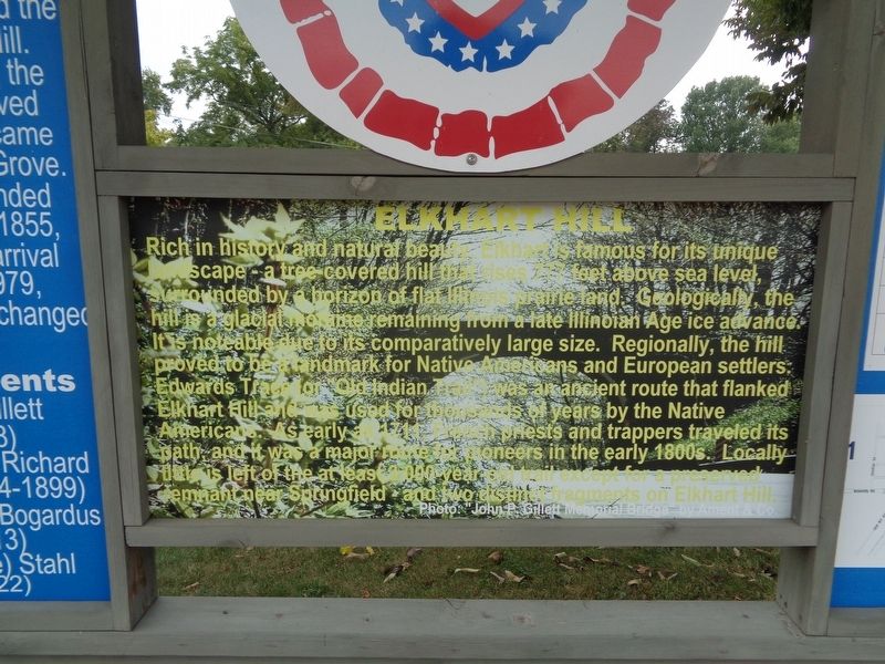
On Bunker Hill Road (Illinois Route 159) 0.1 miles East North Street, on the right when traveling north.
On College Avenue (Illinois Route 140) at Park Road (Illinois Route 140), on the right when traveling west on College Avenue.
On IL-100 (Illinois Route 100), on the right when traveling north.
Near Collins Lane, 0.1 miles north of Collinsville Road.
Near Collins Ln, 0.1 miles north of Collinsville Rd.
Near Collins Lane, 0.1 miles north of Collinsville Road.
On West Street (Illinois Route 157) at West Schwarz Street, on the right when traveling east on West Street.
On South Main Street (Illinois Route 159) south of West Schwartz Street, on the right when traveling south.
On North Main Street (Illinois Route 143/159), on the right when traveling south.
On Collinsville Road, 0.4 miles west of Sand Prairie Rd, on the right when traveling west.
Paid Advertisement
On Illinois Route 100, on the right when traveling west.
On Lewis and Clark Trail south of Frontage Road, on the right when traveling south.
On Monks Mound Trail, 0.2 miles west of Collins Lane, on the right when traveling north.
On Monks Mound Trail, 0.1 miles west of Collins Lane, on the right when traveling west.
On Monks Mound Trail, 0.2 miles west of Collins Lane, on the right when traveling north.
On Collins Lane, 0.1 miles north of Collinsville Road, on the left when traveling north.
On Lewis and Clark Boulevard (Illinois Route 3) 0.2 miles north of West Madison Avenue (Illinois Route 143), on the right when traveling south. Reported missing.
Near Newcut Road, 4 miles south of County Route 6, on the left when traveling east.
Near Newcut Road, 4 miles south of County Route 6, on the left when traveling east.
On North 3100 East Road south of County Route 850N, on the right when traveling south.
Near North 3100 East Road south of County Route 850N.
Near North 3100 East Road south of County Route 850N.
On North Cherry Street north of North Harrison Street, on the left when traveling north.
On Illinois Route 123 at Illinois Route 97 on State Route 123.
On Southeast 3rd Street (State Road 17/94) at Southeast 2nd Avenue, on the right when traveling east on Southeast 3rd Street.
Paid Advertisement
On South Main Street at Ludman Street, on the right when traveling north on South Main Street.
On Limestone Lane at Quarry Road, on the right when traveling east on Limestone Lane.
On Brittany Court, 0.7 miles south of Kasey Lane, on the left when traveling south.
On North Main Street, 0.1 miles north of Magnolia Avenue, on the left when traveling north.
Near Brittany Court, 0.1 miles south of Kasey Lane, on the right when traveling south.
On West Mill Street east of South Main Street, on the right when traveling east.
On South Central Park at Mauvaisterre Street on South Central Park.
Near North River Road (County Road 33) south of East Park Road, on the right when traveling south.
Near North River Road (County Road 33) just south of East Park Road, on the right when traveling south.
On South Galena Trail Road at West Milledge Road (County Road 7), on the left when traveling south on South Galena Trail Road.
On South Galena Trail Road south of West Eagle Point Road (County Road 6), on the right when traveling south.
On South Galena Trail Road, 0.1 miles south of West Eagle Point Road (County Road 6), on the right when traveling south.
On South Galena Trail Road, 0.1 miles south of West Eagle Point Road (County Road 6), on the right when traveling south.
On Spruce Street at West Roosevelt Street (Illinois Route 72), on the right when traveling south on Spruce Street.
On Illinois Route 72 at Spruce Street, on the right when traveling east on State Route 72.
Paid Advertisement
On Park Boulevard, on the right when traveling north.
On Caroline Street south of NE Adams Street, on the left when traveling south.
On West Detweiller Drive, 0.2 miles west of North Galena Road (Illinois Route 29), in the median.
Near North Grandview Drive just east of Irving Park Place, on the left when traveling south.
On West Railroad Street west of North Park Street, on the left when traveling west.
On West Center Street west of North Market Street, on the left when traveling west.
On East Main Street at Federal Street on East Main Street.
On Madison Street east of Columbus Avenue, on the right when traveling east.
On 1st Street just north of Illinois Street, on the left when traveling north.
On Levee Rd., 1 mile south of Roots Rd., in the median.
On Market Street just north of Court Street, on the right when traveling north.
On Market Street just north of Court Street, on the right when traveling north.
On Bluff Road (County Route 7) east of Roscow Hollow Road, on the right when traveling north.
On Bluff Road (County Route 7) east of Roscow Hollow Road, on the right when traveling north.
On Bluff Road east of Roscow Hollow Road, on the right when traveling north.
Paid Advertisement
On Island Avenue at State Street, on the right when traveling south on Island Avenue.
On Island Avenue south of State Street, on the right.
Near 46th Avenue (Illinois Route 3) 0.2 miles east of 15th Street, on the right when traveling east.
Near 46th Avenue (Illinois Route 3) 0.2 miles east of 15th Street, on the right when traveling east.
Near 46th Avenue (Illinois Route 3) 0.3 miles east of 15th Street, on the right when traveling east.
On U.S. 45, 0.1 miles east of East Walnut Street, on the left when traveling east.
Near South Feazel Street just north of Bauman Lane, on the right when traveling north.
On Old Jacksonville Road (County Highway 8) at New Salem Church Road, on the left when traveling west on Old Jacksonville Road.
On Old Jacksonville Road (County Route 8) 0.1 miles east of Peters Road (County Route 8), on the right when traveling west.
On 5th Street just north of E. Adams Street.
Near East Adams Street west of South 6th Street.
On County Route 1a east of Dave Stockton Drive, on the right when traveling west.
On East Lake Shore Drive north of Zoo Trail, on the left when traveling north.
On Lester Street at Elm Street, on the left when traveling west on Lester Street.
On Exeter Bluffs Lane at Water Street, on the right when traveling west on Exeter Bluffs Lane.
On Bob Michael Street east of Carroll Street, on the left when traveling east.
Paid Advertisement
On East 1st Street close to Church Street, on the left when traveling east.
On East 1st Street just east of Church Street, on the left when traveling east.
On East 1st Street, on the left when traveling east.
On Elm Street north of West 2nd Street, on the right when traveling north.
On Ramey Drive south of Collinsville Road, on the right when traveling south.
On Ramey Drive, 0.3 miles south of Collinsville Road, on the right when traveling south.
Near Ramey Street, 0.2 miles south of Collinsville Road.
On Ramey St, 0.5 miles south of Collinsville Rd (U.S. 40), on the right when traveling south.
On Ramey Drive south of Collinsville Road, on the right when traveling south.
Near Ramey Street, 0.6 miles south of Collinsville Road, on the right when traveling south.
Near Major Street west of Ramey Street, on the left when traveling west.
Near Ramey Street south of Collinsville Road, on the right when traveling south.
Near Ramey Street south of Collinsville Road, on the right when traveling south.
On Ramey Street, 0.3 miles south of Collinsville Road, on the right when traveling south.
On Illinois Route 15, on the right when traveling west.
On Lebanon Avenue (County Route 2) east of North Green Mount Road, on the right when traveling east.
Paid Advertisement
On Ramey Street just south of Collinsville Road, on the right when traveling south.
On Ramey Street just south of Collinsville Road, on the right when traveling south.
On North Kent Road just south of U. S. Grant Memorial Highway (U.S. 20), on the right when traveling south.
On West Davie Street west of South Main Street (Illinois Route 146), on the right when traveling west.
Near Interstate 57, 2 miles north of Route 146, on the right when traveling south.
216 entries matched your criteria. Entries 101 through 200 are listed above.
⊲ Previous 100 —
The final 16 ⊳