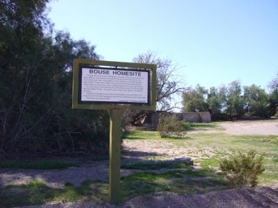
Thomas Bouse was born in Mendecino County, California and came here about 1889 as a prospector and built the first two rooms of his home. He ran a small store here. He brought his wife, Katherine, and infant daughter here in 1892. Three more . . . — — Map (db m29070) HM
This monument built to
perpetuate the memory of
the pioneers, trailblazers,
and adventurers that rest
in these unmarked graves.
(Arizona Highway Department, 1934)
Rededicated: April 27, 2003 (CY 6008)
By the Ancient and . . . — — Map (db m31188) HM
First used sometime after June 16, 1862. Some of Arizona's earliest pioneers, people of every race and moral persuasion, lie here in eternal peace. The last burial was on April 22, 1988. — — Map (db m31827) HM
This small plot of land was designated a cemetery by the Goodyear Tire and Rubber Company of Akron, Ohio. Goodyear owned and farmed the surrounding acreage from 1916 until 1943. Goodyear workers and their families are buried here. Local oral history . . . — — Map (db m34555) HM
Born August 23, 1839 – New Harford, New York
Died April 17, 1923 – Phoenix, Arizona
Buried Greenwood Cemetery
Murphy came to Arizona from Illinois in 1880, to build a section of the Atlantic and Pacific (Santa Fe) Railroad. In . . . — — Map (db m30433) HM
The 1897 Smurthwaite House is an excellent example of Shingle Style Architecture. It is one of fewer than one hundred 19th century buildings of this age left in Phoenix. It was donated to the City of Phoenix Park, Recreation and Library . . . — — Map (db m39414) HM
The first priest ordained in Arizona, Father Edouard Gerard, attended the Catholic people of Phoenix from Florence, Arizona, where he was the pastor of the Church of the Assumption from 1877 to 1885. For many years, Father Gerard was Vicar General . . . — — Map (db m27626) HM
"The markers in this memorial area honor veterans whose remains have not been recovered or identified, were buried at sea, donated to science or cremated and the ashes scattered." — — Map (db m102948) HM
Tempe's first cemetery, named for the Buttes in the background, was established before 1900. It was located on 80 acres of high ground because lower areas were waterlogged. Members of Tempe's best-known families lie here, along with victims of . . . — — Map (db m34556) HM
[Main Marker]Entombment of
George W. P. Hunt
Born 1859 Died 1934
Colorful Arizona pioneer and statesman. Member of various territorial legislatures. President, Arizona Constitutional Convention 1910. Elected Arizona's 1st, 2nd, . . . — — Map (db m30405) HM
This cemetery remains as the last vestige of the pioneer settlement of Hardyville founded in 1864 by William R Hardy, the town served as an important ferry crossing, steamboat landing, shipping point for area mines and as the Mohave County Seat . . . — — Map (db m29339) HM
March 24, 1876, Mormon colonization in Arizona began here with the establishment of Ballanger's Camp, later Brigham City, by Lot Smith, Jesse O. Ballanger, George Lake, William C. Allen and others sent from Utah by Brigham Young. They also . . . — — Map (db m96974) HM
Family Man
Church Leader
Defender of the Prophets
Colonizer
Friend of the Indians
Stockman
Noted Horseman
Defender of Liberty
In January of 1876, Lot Smith was called by President Brigham Young on a mission to captain one of four . . . — — Map (db m185335) HM
Answering the Church's Call
In January of 1876, Brigham Young, the President of the Church of Jesus Christ of Latter Day Saints, announced his plan to establish Mormon colonies in the Arizona Territory. In the months that followed, more than . . . — — Map (db m185328) HM
This monument marks the cemetery and vicinity of the site of Sunset, a Mormon pioneer settlement founded by Lot Smith in March, 1876. The settlers, part of a colonization group called from Utah to Arizona by Brigham Young, came by way of Lee's . . . — — Map (db m185080) HM
Pursuant to judgement rendered in the Superior Court of the State of Arizona, in and for the County of Pima, Case no. 30813, The bodies of persons buried in the Old Clarkston Cemetery which lay approximately 1700 feet northwest of this point, have . . . — — Map (db m82935) HM
Charles Debrille Poston, 1825-1902, often referred to as the "Father of Arizona", promoted territorial status for Arizona during President Lincoln's administration. Poston, motivated by silver mining interests lobbied for federal legislation to . . . — — Map (db m26661) HM
The Pinal Cemetery served the nearby mill town of Picketpost/Pinal (1876 to 1892), which processed the silver ore taken from the Silver King Mine. Resting here in a cross-section of people from the surrounding area: the first settlers, miners, mill . . . — — Map (db m73003) HM
Citizens Cemetery was founded in early June 1864 with the burial of Colorado legislator Joel Woods. Established on public land east of Prescott and southwest of Fort Whipple, the cemetery has been known at various times as “Town . . . — — Map (db m21668) HM
The first burial occurred on this site in 1918. Henry Elmer Cook established the cemetery in 1933 as part of his 160 acre homestead. Many members of Sedona pioneer families are buried here including the city's namesake, Sedona Schnebly. — — Map (db m94833) HM
In memory of
the inmates, who lost their life
while serving their sentence, at the
Arizona Territorial Prison at Yuma
Aldrete, Simon • Alejandra • Alveres, Thomas • Armbula, Tomas • Arnett, William • Arvizu, Gregorio • Baca, Antonio • . . . — — Map (db m51636) HM
Bayou Meto Cemetery was established in 1876 after Allen "Uncle Gip" Gibson donated one acre of land to the local community for use as a cemetery. Gibson, a former Union soldier, was an early settler of the Bayou Meto Community. A skilled . . . — — Map (db m178029) HM
Green Grove Cemetery got its official beginning when Martin and Minnie Buerkle sold two acres of property to the Trustees of Green Grove Cemetery Association in September of 1903. This cemetery was likely the first burial ground dedicated to serving . . . — — Map (db m234960) HM
The Mountain Home Cemetery began with the burial of an 11-month-old child, Willie Russell, in 1857. Willie was the son of County Judge John S. Russell. The lot was owned by Orrin L. Dodd, known as the “Father of Mountain Home,” before it was . . . — — Map (db m243005) HM
So called because steps were dug into the hill so settlers could reach the top.
Once existed two churches, a school and a cemetery. Area named and cemetery started about 1867. — — Map (db m90572) HM
The following 67 names were interred along with 63 more unnamed Paupers here in the Benton County Poor Farm Cemetery between 1877 and 1908.
John Marshall, Elijah Dawson, W.F. Smith, Jake Alverson, Mrs. Dawson, Mr. Douglas, Harriet Lenox, Lipton . . . — — Map (db m299578) HM
Camp Jackson Confederate Gen. Ben McCulloch established
Camp Jackson in July 1861 before marching into
Missouri. After the Aug. 11 Battle of Oak Hills
he returned to Camp Jackson. The 4th Arkansas
Infantry Regiment, which formed Aug. 17, . . . — — Map (db m224988) HM
Soldiers who died at Camp Jackson in 1861
and buried here in unmarked graves
Calhoun Escopets – Co. A
Adolphus P. Williams - Pvt. • Francis C. Harbor - Pvt. • Benjamin F. Bearden - Pvt. • James W. Strong - Pvt. • John C. Farmer - Pvt. • . . . — — Map (db m225001) WM
James Miller Ingram was a captain in the Confederate 6th Provisional Cavalry Partisan Rangers. Years after the war ended, as a self-taught minister he went to preach at a church and was murdered - shot in the back by 19 year old John M. Stone. . . . — — Map (db m68790) HM
1.6 acres for the
purpose of establishing
a church & cemetery.
Donated by L.E. Mason
& Ann Mason (wife)
Deeded July 20, 1861.
Trustees;
Thomas Bingham
Samuel H. Johnson
John Mason — — Map (db m224875) HM
The construction of Bull Shoals Lake displaced the Lead Hill Community, including homes, schools, businesses, and cemeteries, which were removed and relocated here, making it the final resting place for early pioneers and Civil War veterans. — — Map (db m276495) HM
In early April 1857, a large wagon train known as the Fancher-Baker train left Caravan Spring (south of Harrison) and headed for California. They camped at this site en route to intercept the Cherokee trail at the Grand Saline in Indian territory. . . . — — Map (db m225245) HM
Pioneer burial ground on land homesteaded 1880 by James and Rachael McAtee Lamar. Recorded burials begin 1880 after founding of Eureka Springs. May 29, 1889, the 46-acre site deeded to Lodge No. 83 Independent Order of Odd Fellows which maintained . . . — — Map (db m225226) HM
When Judas, betrayer of Jesus, repented and returned the thirty pieces of silver, the chief priests refused them, then “took counsel and bought with them the Potter’s Field to bury strangers in”. Matthew 27:3-10 KJB thus began the tradition. Names . . . — — Map (db m229498) HM
In Memoriam Hyner Cemetery established in 1898 marks the site of those devout, courageous Italian immigrants who came to America in 1895 settling and working at Sunnyside Plantation and throughout the Delta area. They established schools, . . . — — Map (db m168476) HM
This home was built about the year 1848 for John H. Saunders and his wife Martha A. Pettit Saunders. During the Civil War engagement at Ditch Bayou in 1864 the house was used as a hospital for soldiers of both armies. A number of military dead were . . . — — Map (db m107737) HM
East & South of this point was
The Blakely Graveyard
in this first public burying
place of the community, the
early settlers were interred.
It remained in use until 1869
when it was closed to future
burials by the city council. . . . — — Map (db m200782) HM
This early settlement, located on
the military road which connected
Chalk Bluff and Gainesville, is said
to have acquired its name because
stores and houses, were “scattered
about” over the area. Civil War skirmishes were fought here August . . . — — Map (db m255364) HM
Battle of Marks' Mills
On April 23, 1864, a Union force with 240 wagons left Camden to get supplies from Pine Bluff for Gen. Frederick Steele's army. Gen. James Fagan's Confederate cavalrymen ambushed them at Marks' Mills on April 25. . . . — — Map (db m121150) HM
John P. McCown was born Aug. 19, 1815, in Sevierville, Tenn. An 1840 graduate of West Point, he served in the Mexican and Seminole wars before resigning from the U.S. Army on May 17, 1861. McCown joined the Confederate army, rising to the rank of . . . — — Map (db m121139) HM
They married, raised families, shared hopes and sorrows, and now lie within the hallowed grounds of Bold Pilgrim Cemetery. These were the Bold Pilgrims of Conway County.
[Editor's note: For clarity, only first and last names listed. For . . . — — Map (db m282873) HM
Bold Pilgrim is the final resting place for many courageous African Americans who settled in the Hickory Hill community of Conway County, Arkansas after the Civil War. These early African American settlers were fleeing oppressive conditions in . . . — — Map (db m282877) HM
The last Confederate veteran living in Arkansas, William Murphy Loudermilk, is buried here in Keller’s Chapel Cemetery. Private Loudermilk, who was born Oct. 17, 1847, joined a North Carolina regiment in the Army of Tennessee at age 16 and fought at . . . — — Map (db m116195) HM
The Battle of Prairie Grove was a grim moment for the Confederate Army. This conflict severed all chances for the South to use Northwest Arkansas as a route to invade Missouri. The shattered and defeated soldiers retreated from Prairie Grove to Van . . . — — Map (db m96617) HM WM
Erected in memory of
our Confederate soldiers
from Ark., Tex., La., Mo., and
Indian territory,
who lost their lives in the
Battles of Oak Hill, Elk Horn,
and Prairie Grove. — — Map (db m96632) WM
Following is a partial list of persons who died and were buried at Cadron. They perished from cholera while being relocated by the Army in 1834. Graves were marked with native stones with no inscriptions. Some of the Indians had adopted . . . — — Map (db m96643) HM
Faulkner County had divided loyalties during the Civil War. Soon after the war started, Col. A.R. Witt helped organize several companies for the 10th Arkansas Infantry (C.S.). After fighting at Shiloh, the 10th was captured at Port Hudson, La. . . . — — Map (db m119987) HM
Lines Cemetery is the last visible remnant of early communities that existed in the vicinity of Gold Creek south of Conway in the late 19th century. Beginning in the 1870s, families moved into this sparsely populated district; the earliest . . . — — Map (db m290933) HM
Many small towns once existed in the area now covered by Lake Ouachita. Settlers first came to the upper Ouachita River valley in the decades prior to the Civil War to establish homes, farms and businesses, creating communities such as Cedar Glades . . . — — Map (db m108929) HM
Presented by Arkansas Col. John Washington Chapter, National Society Colonial Dames, XVII Century, honoring War Veterans, Early Pioneers, 1998 — — Map (db m61770) HM WM
Dedicated to the memory of Lt. Paul James Riley United States Navy killed 4 June 1942 Battle of Midway awarded The Navy Cross and The Distinguished Flying Cross Greater love hath no man than this that a man lay down his life for . . . — — Map (db m264382) WM
(Left Side)
True to their native soil. They gave their lives to a cause that was lost. Their survivors will never suffer their memory to perish.
(Right Side)
Erected by our citizens to the memory of the Confederate . . . — — Map (db m245989) WM
More than 19 companies formed in Hempstead County to fight for the Confederacy, starting with the "Hempstead Rifles," who mustered in on May 4, 1861. These local men served in the Confederate Congress - Grandison D. Royston and Rufus K. Charles . . . — — Map (db m245848) HM
Established in 1855, the Independence County poor farm provided those in need with a place to live, medical care, and the opportunity to grow their own food in the garden patch. These houses were the community’s way of providing care to the poor . . . — — Map (db m226571) HM
About the year 1826 John Miller, Robert
Crittenden, Charles Kelley and Richard Searcy
verbally gave and dedicated this plot of
ground to the town of Batesville to be used
as a burial place. On April 5, 1856, the
cemetery property, then called . . . — — Map (db m221189) HM
David Hogan brought his family to Walnut
Grove from North Carolina in 1830. He was
buried in 1840 in this cemetery. Three of
his children are buried here; Charlotte,
wife of J.N. Churchill, for whom the
town of Charlotte is named, lies . . . — — Map (db m221078) HM
Land for the Old Baptist Church building and the
adjacent Yeager Cemetery was deeded by Daniel
Yeager in 1897 to the Polk Bayou congregation of
Primitive Baptists for one dollar. The congregation
built a church at this location, yet after a few . . . — — Map (db m170366) HM
Born in Pennington, Ark on Jan. 4, 1937 to John and Itha Lewis. A legend in his time to those who knew him, Joe was a member of the Twitty Bird Band, of which he gave twenty years of service, bringing joy to the hearts of millions of people who . . . — — Map (db m207902) HM
A founder of Lafayette County
First governor of Arkansas
In 1823 James Sevier Conway began a successful plantation in the rich soils near the Red River. In 1826 he married Mary Jane Bradley, a beautiful young women who had moved to the . . . — — Map (db m181517) HM
Home site and grave of John Patterson, son of William Patterson, Born 1790; died 1886; Arkansas' first native born child of Anglo-Saxon parentage. The following riddle was often asked by John Patterson: I was born in a kingdom--Spain, reared in an . . . — — Map (db m258081) HM
Confederate Camp at Richmond
On Aug. 28, 1864, Confederate Gen. Sterling Price led an army from Camden on a raid that took them through Missouri, Kansas and the Indian Territory before they returned to Arkansas at Laynesport in Little . . . — — Map (db m121143) HM
As the Civil War began, the Caroline Home Guard formed at Austin on June 29, 1861. The “Austin Rifles” became Co. I, 5th Arkansas Infantry, C.S.A. Both Union and Confederate troops camped at Austin during the war and Federal troops tore . . . — — Map (db m116330) HM
Thousands of Arkansas and Texas Confederates were camped near this spot in 1862. The camp, named in honor of Brigadier General Allison Nelson, was stricken by disease resulting in 1,500 deaths including Nelson. The dead were buried among these hills . . . — — Map (db m211554) HM
When Gen. Frederick Steele's Union army invaded southwest Arkansas in April 1864, threatening the Confederate state capital at Washington, Gov. Harris Flanagin moved the state archives to Rondo, where they were deposited in James Abraham's store. . . . — — Map (db m96022) HM
Violet Cemetery predates Arkansas statehood, the county, and city, with the oldest grave dating 1831. Initially secluded, the cemetery found itself in the middle of downtown as Osceola grew west because of cotton farming and manufacturing. Many . . . — — Map (db m36709) HM
• Caddo Indian burials were exposed accidentally during construction at this site in October, 1988. Subsequent archeological excavations by Ann Early identified 2 burials, a small cluster of residential features, and artifacts dating from the . . . — — Map (db m202077) HM
The Ephesus Cemetery, listed in the National Register of Historic Places on January 22, 2009, was established for the members and families of the Ephesus Primitive Baptist Church. Thirteen years before the platting of the railroad town of Emmet, ten . . . — — Map (db m184499) HM
Thomas Chipman McRae, born in Mount Holly (Union County), Arkansas, became a courier for the Confederate Army at age twelve, following his father's early death. He attended area schools and later graduated from Washington & Lee University law . . . — — Map (db m184504) HM
The Death of General Patrick Cleburne
“If we are to die Govan, let us die like men,” Cleburne said to his friend, Daniel Govan, as he rode to his death.
Major General Patrick Ronayne Cleburne, Helena’s best-known Confederate . . . — — Map (db m107829) HM WM
The Confederate Memorial
In 1889, the Phillip County Memorial Association began raising funds to erect a grand memorial to honor all the Confederate dead.
The Association sent an appeal throughout the South and donations poured in. Not . . . — — Map (db m107834) HM
"I am with the South in life or death, in victory or defeat."
Patrick Cleburne, May 1861
A Brilliant and Beloved Commander
Patrick Cleburne was a brilliant military tactician and one of
the . . . — — Map (db m109146) HM
front:
Patrick Ronayne Cleburne,
Major General, C.S.A.
Born in County Cork,
Ireland,
March 17, 1828;
Killed at Battle of
Franklin, Tenn.
November 30, 1864.
Dulce et decorum est
Pro patria mori.
Shiloh . . . — — Map (db m86787) WM
“It is hoped that the younger generations, which have witnessed their unselfish devotion will emulate their virtues.”
Memorializing the Confederate Dead
Immediately after the Civil War, Southern women began efforts to care . . . — — Map (db m107831) HM
Legendary singer and guitarist Glen Campbell was born in Billstown, Arkansas on April 22, 1936. He died in Nashville, Tennessee on August 8, 2017 after a courageous battle with Alzheimer's disease. Campbell brought country music to the mainstream as . . . — — Map (db m184564) HM
The Cephas Washburn home stood a few hundred feet northeast of this cemetery. Washburn purchased this land in 1857, and spent the last years of his life residing here in Pope County. It was in this house that Edward Payson Washburn, Cephas . . . — — Map (db m225448) HM
In 1845 the Russell Beall family donated land for Bayou Meto Cemetery. Soon afterward a two story log building was erected in a grove of oaks. Known as Bayou Meto Chapel, the structure served as church, public school and meeting place for Jacinto . . . — — Map (db m116645) HM
The 4th Arkansas Infantry Battalion (C.S.) enlisted at Little Rock on Nov. 10, 1861. It included Capt. T.F. Murff’s Co. A, the ‘Bayou Metre Hornets,’ which had received a flag at an Oct. 18 barbecue at modern-day Jacksonville. The regiment fought at . . . — — Map (db m116350) HM
(Continued from other side)
William Thomas Graham
John Robert Hall
Newton Fredrick Harpole
Martin Christian Herman
Alfred W. Johnson
John Thomas Lucas
George H. McCain
Ben McHenry
Lewellyn McHenry
M. J. McHenry
James S. Merritt . . . — — Map (db m205821) HM
During the nineteenth century, waves of German-speaking immigrants settled in Pulaski County. Establishing themselves here as early as 1833, these families had a significant impact on the development of the area through their work as farmers, . . . — — Map (db m220389) HM
In memory of her soldiers who lost their lives in the service of the United States in the war for the preservation of the Union.
A.D. 1861—1865 — — Map (db m180357) WM
Civil War Dead
An estimated 700,00 Union and Confederate soldiers died in the Civil War between April 1861 and April 1865. As the death toll rose, the U. S. government struggled with the urgent but unplanned need to bury fallen Union troops. . . . — — Map (db m181345) HM
The Old Confederate Cemetery
Confederate forces occupied Little Rock, Arkansas, from 1861 until September 1863, when the Union Army captured it after a forty -day campaign. As they occupied the city , both armies reported soldiers dying almost . . . — — Map (db m180935) HM
National Cemetery
The Union Army buried their dead in the southeast corner of the new cemetery—now Oakland—Fraternal Cemetery. In 1868, the federal government purchased additional land adjacent to the original burials and the 12.1-acre . . . — — Map (db m180795) HM
This facility is dedicated to the men and women who answered their country's call to service. Their inspiring contribution will help preserve in the hearts and live of all Americans the spirit of patriotism, the love of Country and the willingness . . . — — Map (db m180368) WM
John Jackson and his wife Anna Jackson came to Little Rock in the 1880s, along with
their employers. They farmed land, some now under water, on the banks of the
Arkansas River in the vicinity of this ramp. In July, 1913 they sold a small parcel . . . — — Map (db m208843) HM
In January 1811 a group of families left Alabama for what was to become the Arkansas territory. They traveled by boat down the Tennessee, Ohio, and Mississippi rivers to Arkansas Post, a settlement at the mouth of the Arkansas River. This group was . . . — — Map (db m282878) HM
13397 entries matched your criteria. Entries 401 through 500 are listed above. ⊲ Previous 100 — Next 100 ⊳