On East Hancock Street, 0 miles west of College Avenue, on the left when traveling east.
Dr. Moses Waddel, educator and minister, was born in 1770 in N.C. At fourteen he began teaching pupils near his home. Moving to Ga. In 1786, he taught in the Greensboro area until 1787, opening another school at Bethany, Greene County, in 1788. . . . — — Map (db m38874) HM
On E. Hancock Avenue west of College Avenue, on the right when traveling west.
First Presbyterian Church Athens, Georgia Founded 1820 Has been placed on the National Register of Historic Places by the United States Department of the Interior Erected 1855 — — Map (db m121079) HM
On West Dougherty Street at Hull Street, on the left when traveling east on West Dougherty Street.
Originally from Macon, Georgia, African-American architect Louis H. Persley attended Lincoln University, and graduated from Carnegie Institute of Technology in 1914. Persley then joined the faculty of the Tuskegee Institute in Alabama. One of his . . . — — Map (db m11753) HM
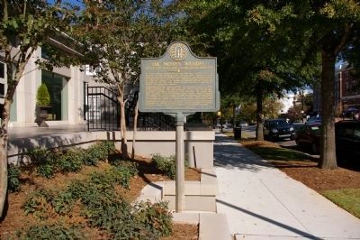
On North Milledge Avenue (Georgia Route 15) 0 miles south of West Hancock Street, on the right when traveling south.
Lucy Cobb Institute, a College for Girls, was established in 1858 through the effort of T. R. R. Cobb and named for his daughter, Lucy. Later, three of his nieces taught here: Miss Mildred Rutherford, Principal, Mrs. Mary Ann Lipscomb, Mrs. Bessie . . . — — Map (db m208807) HM
On Oconee Street, on the left when traveling east.
This bell was purchased for and hung in the original Oconee Street Methodist Episcopal Church, South, located at 142 Oconee Street. It is the first known item to represent the church in the Athens community, arriving in August 1870, before the . . . — — Map (db m207853) HM
On Salem Church Road (County Route 29) 0.5 miles east of U.S. 221, on the left when traveling east.
Salem Church was built in 1889 on the Kinnaird Trail -– an Indian pathway that later became a stagecoach relay station. Martin S. Corbett was born here on 5-12-1840 and married cousin, Leonora Wealtha Pafford on 11-26-1867. Their home was . . . — — Map (db m53290) HM
Near Millford Church Road, 0.3 miles north of Georgia Route 216, on the left when traveling north.
Milford Baptist Church stood on this site for more than 120 years from about 1880 until February 2002. These rocks served as pillars for that building just as Milford Baptist Church has been the foundation of this community since 1834. The . . . — — Map (db m218688) HM
On Sparta Highway (Georgia Route 22) at Montpelier Church Road, on the right when traveling east on Sparta Highway.
This church is named Montpelier after Fort Montpelier of 1794, 1/2 mi. below here down the Oconee. This fort & others were built during the Creek Indian troubles. Capt. Jonas Fouche was ordered to guard the Ga. frontier from the mouth of the Tugaloo . . . — — Map (db m36103) HM
On Allen Memorial Drive at Ivey Drive, on the right when traveling west on Allen Memorial Drive.
This is the site of the antebellum college established in the community of Midway by the Hopewell Presbytery in 1833. Its first president, Carlisle P. Beman, was succeded by Samuel K. Talmage. In 1861, students and faculty entered Confederate . . . — — Map (db m10803) HM
On North Jefferson Street at East Hancock Street (Georgia Route 22/24), on the right when traveling south on North Jefferson Street.
The first Catholic mass was celebrated at Milledgeville in April, 1845, at the Hugh Treanor apartment in the Newell Hotel. Bishop Ignatius Reynolds of the diocese of Charleston, accompanied by Father J. F. O’Neill, visited here in 1847. In 1850 this . . . — — Map (db m36357) HM
On South Wayne Street at West Washington Street, on the right when traveling north on South Wayne Street.
This Church was organized in 1841 through the efforts of Bishop Stephen Elliott. The church building was completed in 1843 and consecrated Dec. 10. The vestibule, annex and Gothic roof were added later. The handmade chancel furniture was given by . . . — — Map (db m36104) HM
On South Wayne Street at East Greene Street, on the right when traveling north on South Wayne Street.
On this tract of twenty acres was built the Statehouse, the original wing of which was completed in 1811. Later additions were made until 1835 when it was finished in its present form. Near the Statehouse stood the Arsenal and the Magazine, brick . . . — — Map (db m36404) HM
This marks the original site
of the Methodist Church erected
about the year 1805.
Bishop Asbury and Bishop
McKendree in 1815 held here
a conference which James O.
Andrew attended.
Bishop Capers, Dr. Lovick Pierce,
and many other . . . — — Map (db m42773) HM
On Gordon Highway (Georgia Route 243) at Colony Farm Road, on the right when traveling south on Gordon Highway.
This house, now the Du Bignon home, was once the home of John Clark, Governor of Georgia. At the age of 16, John Clark fought with his father, General Elijah Clark, distinguished Revolutionary soldier, at the decisive Battle of Kettle Creek. . . . — — Map (db m13138) HM
On Old U.S. 441 at Line Church Road, on the right when traveling south on U.S. 441.
The Line Baptist Church was constituted Sept. 13, 1802, by Rev. Moses Sanders, Thomas Maxwell and Daniel White.
This church was just over the line between Georgia and Cherokee lands. Meetings couldn’t be held at night, because all white people . . . — — Map (db m40651) HM
On Georgia Route 105, 0.3 miles east of Andrews Road, on the right when traveling east.
Leatherwood Baptist Church was established in 1801 at Eastanollee in Franklin County. Many members moved near here, organized this church and named it Leatherwood. Members remaining in Eastanollee reorganized and named their church Eastanollee. Land . . . — — Map (db m40703) HM
On Georgia Route 51, 0.1 miles west of Damascus Road (Old Georgia Route 184), on the right when traveling east.
In 1780 a group of people, Garrisons and Wilmonts, met on the top of the hill behind the church, built a platform between two trees, and held a religious meeting. This small gathering, and the statement that it was pleasant to worship on the . . . — — Map (db m16995) HM
On Georgia Route 51, 0.1 miles west of Martin Bridge Road (Georgia Route 63), on the right when traveling west.
Nails Creek Baptist Church, the first Baptist Church in Banks County, was established February 11, 1787. It was the Mother Church of Middle River, Grove Level and Indian Creek. Many descendants of its charter members are active in the work of the . . . — — Map (db m14473) HM
On 6th Avenue at 7th Street, on the right when traveling east on 6th Avenue.
Perry-Rainey Institute founded 1892 by Mulberry Baptist Assn. at Appalachee Baptist Church, Auburn.
Predecessors of Perry-Rainey Institute - Harmony Grove Academy, Mulberry High School and Perry-Rainey College.
Named for Reverend Hiram . . . — — Map (db m14883) HM
Near Christmas Avenue (Georgia Route 11) at Manger Avenue, on the right when traveling south.
Oldest Methodist Church in Barrow County, organized in the 1780’s. Services first held two miles N.E. in log house. In 1790 a church was built nearby. The present site was originally a camp ground with an arbor, tents & cottages for camp meetings. . . . — — Map (db m46843) HM
On Old Thompson Mill Road, 0.1 miles south of Farm Market Road, on the right when traveling south.
Clayborn Dalton built an arbor for public Worship across Mulberry River in Jackson County in the early 1800’s. It was called “Dalton’s Stand”. In 1813 the church was moved on this side of Mulberry River near the Maynard Cemetery. Rev. . . . — — Map (db m16125) HM
On Broad Street, 0 miles east of Elizabeth Street, on the left when traveling east.
Educator; 52 years service in education. Born Feb. 12, 1900 Ila, Ga., Graduate of University of Georgia. Taught: Maysville, Cornelia, Buford 1920-1933. Principal - Coach Statham School 1933 - 1957. Supt. Barrow County Schools 1957 - 1965. Professor . . . — — Map (db m17364) HM
On Georgia Route 82 at milepost 4,, 0.1 miles east of Steed Road, on the right when traveling east.
Served 3 years in Revolutionary War from Dinwiddie Co., Va. in Buford’s Detachment.
Lost an arm at Waxhaws, May 29, 1780.
Remembered as successful business man, educator and civic worker, but most outstanding as devout Methodist minister. . . . — — Map (db m19763) HM
On West Athens Street (Georgia Route 211) 0 miles east of Church Street, on the left when traveling east.
In 1836 Byrd Betts, Pioneer Steward of the Concord Methodist Church, later to become the First Methodist Church of Winder, gave 10 acres land for the church and cemetery. Those known buried here.
On Gainesville Highway (Georgia Route 53) at Rockwell Church Road, on the right when traveling north on Gainesville Highway.
Organized 1839 — second oldest Universalist Church in Georgia. Located here near original site of Rockwell School, oldest school in this section, and Rockwell Masonic Lodge. Confederate Soldiers enlisted and drilled here 1861-1865. Church . . . — — Map (db m19548) HM
On West Athens Street (Georgia Route 211) at Church Street, on the left when traveling east on West Athens Street.
For years inestimable the CREEK INDIAN VILLAGE of SNODON stood here. In 1793 ALONZO DRAPER, HOMER JACKSON and HERMAN SCUPEEN and their families became the first white people to establish homes in SNODON. This same year SNODON became JUG TAVERN. In . . . — — Map (db m17349) HM
On Tennessee Road (U.S. 411) at Old Tennessee Road, on the right when traveling north on Tennessee Road.
Dr. William H. Felton and his wife, Rebecca Latimer, lived from 1853 until 1905 in the house east of this marker.
A physician, minister and noted orator, Dr. Felton was the leader of the Independent Revolt from the State Democratic Party in . . . — — Map (db m13483) HM
On Georgia Route 293, 0.1 miles north of Old River Road, on the right when traveling north.
This site was donated by Arnold Milner, owner of a farm on the Etowah River, to be used for a church and cemetery for his family and friends. Friendship Presbyterian Church held its first services here on February 26, 1843. The church met here until . . . — — Map (db m56367) HM
On West Cherokee Avenue, 0.1 miles west of South Bartow Street, on the right when traveling east.
Sam P. Jones was born October 16, 1847, in Oak Bowery, Alabama; he moved to Cartersville with his parents in 1856. After his admission to the Georgia Bar in 1868 he married Laura McElwain. In 1872 he was licensed as a Methodist Minister. His . . . — — Map (db m21695) HM
Initiated in Cartersville Lodge No. 63 on June 2, 1891, passed on June 30, & raised on
Aug. 4, 1891. Was W.M. 1893, 1894, 1899 & 1901. Jr. Grand Warden of the Grand Lodge of GA in 1897 & 1898. Judge of Cartersville City Court, President of City . . . — — Map (db m53015) HM
Near West Main Street (Route 113) west of South Public Square, on the right when traveling west.
Teacher, Missionary to China. Born December 12, 1840, Abermarle County, Virginia. Died December 24, 1912 en route from China at Kobe, Japan, buried Crewe, Virginia. Moved here in 1871 to open Cartersville Female Seminary, which she and Anna C. . . . — — Map (db m190671) HM
Near West Main Street (Georgia Route 113) west of South Public Square, on the right when traveling west.
Evangelist, Methodist Minister. Born Oak Bowery, Alabama, October 15, 1847; died Oklahoma, October 15, 1906; buried Oak Hill Cemetery.
Having failed as an alcoholic lawyer, promised his dying father to stop drinking. Found religion and became the . . . — — Map (db m190668) HM
On West Main Street at School Street, on the right when traveling west on West Main Street.
For 20 years, thousands came annually to this site, attracted by the magnetic personality and forceful eloquence of Sam Jones, renowned Evangelist and Christian crusader.
Here he built, in 1886, at his own expense, a large open-air structure, . . . — — Map (db m40571) HM
Near West Main Street (Georgia Route 113) west of South Public Square, on the right when traveling west.
Lawyer, minister, politician. Born Elbert County, Georgia, October 9, 1811. Died Cartersville, Georgia, December 17, 1877; buried Cassville Cemetery.
Opened law office in Cassville, Georgia in 1836, argued first case before Georgia Supreme Court . . . — — Map (db m190658) HM
On Cassville Road NW (Old Route 41), on the left when traveling south.
In this valley was once situated the proud town of Cassville, begun in July 1833, as the seat of justice for Cass County and soon the center of trade and travel in the region recently comprising the Cherokee Nation. Both the county and town where . . . — — Map (db m12371) HM
On West Main Street at Elliott Street, on the right when traveling east on West Main Street.
The original church, with another name and at another location, was built in 1845, rebuilt in Kingston in 1854, and dedicated by Rev. Lovick Pierce, a leading preacher of the nation and father of Bishop George F. Pierce. The only church remaining . . . — — Map (db m13537) HM
On Euharlee Road at Macedonia Road, on the right when traveling west on Euharlee Road.
In 1864, a road southward from Wooley's Bridge (Etowah River) crossed the road near this point and ran to Van Wert (Rockmart) and Dallas. This was the route of McPherson's Army of the Tennessee (15th and 16th Corps.), [US] right wing of forces . . . — — Map (db m13926) HM
On Hall Station Road, 1.4 miles north of Kingston Highway (Georgia Route 293), on the left when traveling north.
Ante-bellum plantation and residence of the Rev. Charles Wallace Howard, where he established a private school. May 18, 1864. Hardee's A.C. [CS] moved from Adairsville to Kingston on this road enroute to Cass Station. May 19, the 4th and 14th A.C. . . . — — Map (db m13195) HM
On Mount Pleasant Road, 1.7 miles Georgia Route 140, on the right when traveling north.
Author of "A Circuit Rider's Wife" and many other books and articles, lived from 1913 until her death in 1935.
The most productive years of her career were spent in a picturesque log cabin, which, according to legend, was once the home of a . . . — — Map (db m13230) HM
On Mt. Pleasant Road east of Nally Road, on the right when traveling east.
On this historic site a Baptist Church was established on September 5, 1891, by a group of courageous Mount Pleasant Community citizens. The Church was named Mount Pleasant Baptist Church. The present Church which was built in 1948 stands across the . . . — — Map (db m171193) HM
On U.S. 411 at Pine Log Road (Old Georgia Route 140), on the left when traveling north on U.S. 411. Reported missing.
250´ west of this marker stands, Historic Pine Log Methodist Church, Cemetery, tabernacle, and Camp Grounds, established in 1834. The oldest Church in continuous use in Cass/Bartow County. This Church area is on the national Register for Historic . . . — — Map (db m44782) HM
On Pine Log Road NE, 0.1 miles west of U.S. 411, on the right when traveling west.
The church, built 1842; campground and tabernacle, 1888; and cemetery, begun in 1850, were listed in the National Register of Historic Places September 9, 1988. The Methodist organization was founded on this site by Stephen Ellis about 1845 in a . . . — — Map (db m110798) HM
On Merrimac Drive at Jessamine Street, on the left when traveling south on Merrimac Drive.
This bell was awarded to the First Baptist Church by Governor William J. Northen (1833-1913) to honor the first church built in the Colony City of Fitzgerald. Governor Northen was an outstanding Baptist layman who graduated from Mercer University at . . . — — Map (db m11705) HM
On Bethlehem Church Road, 0.1 miles south of Broom Road, on the left when traveling south.
Ozias Primitive Baptist Church was constituted July 14, 1832. Elders Wilson Conner and John Martial were the Presbytery. Members were John McDonald, Randall McDonald, Elijah Hunter, Penelope Hunter, Catherine McCall, Mary McDonald, Elizabeth . . . — — Map (db m57153) HM
On Shurling Drive, 0 miles west of Gray Highway (U.S. 129), on the right when traveling west.
Founded in October 1899 by the Reverend E. K. Love under the auspices of the Missionary Baptist Convention of Georgia, Central City College served as a co-educational institution of learning for African-American students at both the high school and . . . — — Map (db m23065) HM
On Walnut Street, 0 miles east of 2nd Street, on the right when traveling east.
The Reverend Lot Jones, while on a missionary tour of Georgia, founded Christ Episcopal Church on March 5, 1825. It was the first congregation organized in Macon. On December 26, 1826, the Georgia General Assembly enacted, “that Christopher B. . . . — — Map (db m49579) HM
On Willie Smokie Glover Drive, on the right when traveling west. Reported missing.
In May 1539 Hernando de Soto landed in Florida with over 600 people, 220 horses and mules, and a herd reserved for famine. Fired by his success in
Pizarro's conquest of Peru, De Soto had been granted the rights, by the King of Spain, to explore, . . . — — Map (db m27272) HM
Edward D. Tracy, Jr., was born in Macon, Georgia, on Nov. 5, 1833. His father served as Macon’s second Mayor (1826-1828), a Judge of Superior Court, and hosted General Lafayette during his visit to Macon in 1825. The younger Tracy graduated from the . . . — — Map (db m25388) HM
On 1st Street at Mulberry Street, on the left when traveling west on 1st Street.
On his first Sunday in Macon in 1864, artillery officer Captain Thomas Key from Alabama visited the largest church in the city.
The Presbyterian Church (2 see map) on Mulberry with seating for 800 was built in 1858, having been relocated twice . . . — — Map (db m236725) HM
On Coleman Avenue at College Street, on the right when traveling east on Coleman Avenue.
Founded in Penfield, Georgia, January 14, 1833, as Mercer Institute, Mercer University, the “oldest child” of the Georgia Baptist Convention, has been the chief source of Baptist ministerial and lay leaders through the years. Among the . . . — — Map (db m44946) HM
On Mulberry Street west of 1st Street, on the right when traveling west.
Mulberry Street Methodist Church Mother Church of Georgia Methodism
Organized 1826 ∙ First Building 1828
Second Building 1850 ∙ Third Building 1883
Present Building 1928 Georgia Conference organized here Jan. 1831 No . . . — — Map (db m236727) HM
On Mulberry Street at 1st Street, on the right when traveling west on Mulberry Street.
This church, organized in 1826, is on land deeded to it by the Georgia Legislature in the same year. In 1828, the first church building in Macon was erected on this site. The first appointed pastor was Thomas Darley, who had been ordained by Bishop . . . — — Map (db m29210) HM
On Poplar Street at New Street, on the right when traveling east on Poplar Street.
The history of Roman Catholicism in Macon dates to a visit in 1829 by Bishop John England of the Diocese of Charleston and the subsequent migration of Irish Catholic families in the 1830s. In 1841 Macon's Catholics received their first pastor, . . . — — Map (db m22189) HM
On Ward Street, 0.1 miles north of Vineville Avenue (U.S. 41), on the right when traveling north.
This African-American parish began in 1888 and was named St. Peter Claver in 1903, in honor of the Patron Saint of Negro Missions. The current school, convent, and rectory were built here after the parish moved from Pio Nono Avenue in 1913. The . . . — — Map (db m25123) HM
On Cherry Street at Spring Street (Georgia Route 19), on the right when traveling east on Cherry Street.
Jewish-Americans have played a significant role in the economic,social and political life of Macon since the 1840s. To meet their growing religious needs, they established Orthodox Congregation Kahal Kadosh Beth Israel in 1859 in downtown Macon. The . . . — — Map (db m155592) HM
On Washington Avenue (U.S. 41) at High Place, on the right when traveling east on Washington Avenue.
This church was founded in 1826 as the city’s first Baptist congregation. It was first located at the site of the present Bibb County Courthouse. The fourth and final move, to this site, occurred in 1883 and the current building was dedicated in . . . — — Map (db m23046) HM
On Mulberry Street at 1st Street, on the right when traveling east on Mulberry Street.
Organized as the Presbyterian Church of Macon on June 18, 1826, by the Rev. Benjamin Gildersleeve and the Rev. Joseph C. Stiles, the church dedicated this house of worship, its third, on September 19, 1858, at the close of the ministry of the Rev. . . . — — Map (db m44944) HM
On Vinevile Avenue (U.S. 41) at Forest Avenue, on the right when traveling west on Vinevile Avenue.
Vineville United Methodist Church, the oldest daughter of Mulberry Street United Methodist Church, was begun in 1846 to serve wealthy planters of the village of Vineville, just outside Macon. It has been located on this site since 1897. The current . . . — — Map (db m44570) HM
On College Street at Georgia Avenue, on the right when traveling south on College Street.
Led by the Methodist Community, a citizens’ committee in the city of Macon founded Wesleyan as the first baccalaureate college for women. The Georgia Conference of the Methodist Episcopal Church accepted the college from the committee, appointed a . . . — — Map (db m55010) HM
On Golden Isles Highway (U.S. 23) 0.3 miles north of Coley Station Road (Georgia Route 112), on the right when traveling north.
Evergreen Baptist Church, built in 1844, was split off from old Mt. Horeb Baptist Church, constituted October 15, 1809, which stood at or near the site of the Centenary Methodist Church. On February 14, 1844, the congregation and pastor found . . . — — Map (db m40312) HM
On Longstreet Church Road, 0.5 miles south of Broadhead Road, on the left when traveling north.
Longstreet Methodist Church was organized around 1812 and the original building is still in use. Land for the church was given by Charles Walker, one of the five sons of George Walker, Revolutionary soldier and early settler. The sons built on a . . . — — Map (db m40313) HM
On Beasley Road (County Route 79) 0 miles Grooverville Road (County Route 275), on the left when traveling north.
This church had its beginning in 1832, on the plantation of William H. Ramsey, about 4½ miles Southwest of here. There being no Methodist services in the vicinity at the time he and his family moved to this area. Mr. Ramsey built a brush-arbor . . . — — Map (db m10025) HM
Near Liberty Church Road (County Route 94) 0 miles north of Grooverville Road (County Route 275), on the right when traveling west.
Between 1837 - 1841 the Baptists in this section were stirred on Missions, Sunday Schools and ministerial support. In 1841 the Ocklochnee anti-Missionary Baptist Assn. passed a ruling to dismiss members believing in the “new fangled . . . — — Map (db m10172) HM
On Campground Road, 0 miles east of Adel Highway (Georgia Route 76), on the left when traveling south.
The first Camp Meeting was held on this site in 1828 by a "few scattered Methodists" before any Methodist Church in the area was organized. William Hendry, William Blair and Hamilton W. Sharpe, as a committee, selected the site. Rev. Adam Wyrick was . . . — — Map (db m14761) HM
On Radford Road (County Route 114) 0.8 miles west of Madison Highway (Georgia Route 333), on the left when traveling west.
Columbia Primitive Baptist Church was formally constituted on the first Sunday in October, 1833, after serving as an arm of Bethany Church more than a year. Moses Dees was the first delegate from Columbia to the annual meeting of the mother church, . . . — — Map (db m14749) HM
On Bethel Church Road, 1.5 miles south of Georgia Route 122, on the left when traveling south.
Bethel Primitive Baptist Church, the second Baptist Church to be organized in the area of old Lowndes County, was constituted September 2, 1826. The
organizing Presbytery were: Elders Benjamin Manning. Matthew Albritton and Henry Melton, with . . . — — Map (db m51514) HM
On Bethlehem Church Road at Grooverville Road, on the left when traveling south on Bethlehem Church Road.
Bethlehem Primitive Baptist Church about 4 miles Southwest of here, was constituted November 29, 1834. The charter members included: William T.
Rushing, his wife, Belinda; Asa Geiger, his wife, Nancy; William Jones, his wife, Elizabeth; James . . . — — Map (db m14747) HM
On Belfast-Keller Rd, on the left when traveling west.
This church, the oldest congregation in lower Bryan County, was certified by the Presbytery of Georgia in 1830. Its founders included rice planters on Bryan Neck, among them Thomas Savage Clay, Richard James Arnold and George Washington McAllister. . . . — — Map (db m18648) HM
On Bryan Neck Road (Georgia Route 144) at Carver School Road, on the left when traveling south on Bryan Neck Road.
Organized in 1869, this is the oldest African-American church congregation in lower Bryan County. The first structure for the church, a Prayer House, was built in 1870 on this site near the white Presbyterian Church (Burnt Church). London Harris, a . . . — — Map (db m54193) HM
On Henry Ford Avenue (Georgia Route 144) at Pinecrest Avenue, on the right when traveling east on Henry Ford Avenue.
The congregation of the Canaan Baptist Church, primarily African-American, was organized in 1913 by Rev. David Boles, Sr., who was pastor, and Brother Fred Gilbert, Deacon. It was the only organized denominational church in what is now Richmond Hill . . . — — Map (db m59957) HM
On Henry Ford Avenue (Georgia Route 144) 0 miles north of Constitution Way, on the right when traveling south.
Henry and Clara Ford had this chapel built in 1937 near the Community House and the Ways Station School. The chapel was named for the mothers of Henry Ford (Mary) and Clara Ford (Martha). Students from the nearby school utilized the Martha-Mary . . . — — Map (db m54319) HM
On Mud Road, 0.1 miles west of Black Creek Church Road, on the right when traveling west.
(Side 1):
Upper Black Creek met each month on the third Sunday and Saturday before from the time she was organized in 1802 until the Church elected to meet every Sunday in 1957. Conference was every month on those Saturdays, and Upper . . . — — Map (db m38614) HM
On Mud Road, 0.1 miles west of Black Creek Church Road, on the right when traveling west.
Upper Black Creek Primitive Baptist Church was constituted on August 15, 1802 in the home of John Albritton. The organizing presbytery consisted of Henry Cook, Isham Peacock, John Goldwire and Henry Holcombe. With a membership upward of 40 members. . . . — — Map (db m38612) HM
On Old River Road North (County Route 474) at Jones Ln Memorial Highway (U.S. 301), on the right when traveling west on Old River Road North.
Three miles east of this point, on the old River Road, is located Union Meeting House (Methodist), the oldest church in Bulloch county, and one of the oldest churches in Georgia remaining continuously active since its organization. Title was . . . — — Map (db m10890) HM
On Portal Highway at Westside Road, on the right when traveling north on Portal Highway.
Organized circa 1829, the church was originally located at the home of Absolom Parrish and called Parrish Meeting House. Following a fire of the log structure on the Parrish farm, the congregation built a second log structure one and one-half miles . . . — — Map (db m107078) HM
On Main Street (U.S. 301) near Sharpe Street, on the right when traveling north.
Charter Members
Deacon Edmond Kennedy, Deacon A. B. Miller, W.B. Corey, Joseph Tillman, James Price, J. J. M. Griner, Moselle Miller, Mary Tillman, Elizabeth Kennedy, Mary J. Proctor
"We covenant with God and with each other … . . . — — Map (db m10543) HM
On Harville Road at Langston Chapel Road, on the right when traveling south on Harville Road.
Organized 1897
Land donated by Charley Akins, James B. Rushing,
James W. Warnock and Laura Rushing Warnock
First Pastor: Elder Daniel R. McElveen
Charter Members
Elder Daniel R. McElveen, Maggie Warnock McElveen,
Charley Akins, Maggie . . . — — Map (db m197932) HM
On Old River Road (Georgia Route 24) 0.1 miles east of Burkhalter Road, on the left when traveling east.
Organized from Union by Rev. Lewis Mayers, New Hope was Bulloch’s second Methodist Church. 1804 trustees were David Kennedy, Josiah Everette, Jarvis Jackson, Burrell Whittington and William M. Kennedy: other leaders were Joseph Hodges, Eli Kennedy . . . — — Map (db m107020) HM
On Old River Road N, also Clito Road (County Route 474) at Unnamed unpaved farm road, on the left when traveling west on Old River Road N, also Clito Road.
In 1790, John Crawford and Phillip Mathews, Burke Circuit preachers, organized a Methodist Society in the home of Joshua Hodges, Sr. In 1791, Union Meeting House became a frequent entry in Circuit records. In 1794, Union Trustees obtained from . . . — — Map (db m107051) HM
On Winter Road, 0.2 miles west of Mark Walden Road, on the left when traveling west.
Hopeful was organized in October 1814 when members of the “Church at the Pinewoods Meeting House” purchased land on which the meeting house stood for $10. The first minutes of Hopeful's history was the legal indenture recording the name “Hopeful”: . . . — — Map (db m200159) HM
Near Bark Camp Church Road, on the left when traveling west.
Constituted in 1788, Bark Camp Church was the center for worship, culture and hospitality in Bark Camp,
one of the oldest settlements in Burke County.
Many of the congregation honorably served during the War Between the States as soldiers . . . — — Map (db m97007) HM
On State Highway 56 at Bark Camp Church Road, on the right when traveling south on State Highway 56.
Constituted in the early part of 1788, Bark Camp Baptist Church was a center for culture and hospitality in Bark Camp, one of the oldest settlements in Burke County and a community of wealthy and prominent plantation owners. Among the 29 charter . . . — — Map (db m44549) HM
On Old Sardis Road west of Cemetery Street, on the right when traveling west.
Erected 1810
Rebuilt 1847
Dismantled 1940 and material used in erecting pastorium in Sardis.
Originally Beech Branch Meeting House constituted in 1803. — — Map (db m12491) HM
On Pine Street at Burke Street, on the right when traveling north on Pine Street.
On Sept. 28, 1803, a group of men living in Burke County near Beech Branch Meeting House, "found to be in the true Baptist faith", by a presbytery of Rev. Henry Hand and Rev. John Ross, were constituted into one Body as a Baptist Church. A church . . . — — Map (db m18718) HM
On Botsford Church Road, 0.1 miles east of Cemetery Road, on the right when traveling west.
Botsford Church, Constituted in 1773 by the Rev. Edmund Botsford, was the second Baptist church in Georgia. Originally located 25 miles below Augusta, known as the New Savannah Church, it was moved about 10 miles to this place after the Revolution. . . . — — Map (db m13116) HM
On Myrick Street at Williams Street, on the right when traveling north on Myrick Street.
Scotch Presbyterians of St. George's Parish, now Burke County, by 1760 had organized churches at Brier Creek, Old Church (formerly Episcopalian) and Walnut Branch. In 1771 Rev. Josiah Lewis became the first permanent pastor, sent by the Synod of New . . . — — Map (db m40268) HM
On South Lee Street (U.S. 17) just north of West William Avenue, on the left when traveling north.
Joe H. Joseph (Seated) Joe H. Joseph was one of the eldest sons of Jacob and Isabella Joseph. Joe married Katie Baker Joseph and they raised 14 children, seven boys and seven girls. Joe, not only followed his father Jacob with the . . . — — Map (db m222212) HM
On Osborne Street (Georgia Route 40) 0 miles north of West Conyers Street, on the right when traveling south.
Built by public subscription as a place of divine worship for inhabitants of St. Marys and its vicinity. Reverend Horace Southworth Pratt was ordained and installed as the first pastor by the Presbytery of Georgia in June, 1822. Incorporated under . . . — — Map (db m21062) HM
Near Bartlett Street at St Marys Street West, on the left when traveling north.
From roughly 1568 through 1684, twelve Spanish missions were established from St. Augustine to what is now coastal South Carolina. On Cumberland Island, the Franciscan mission San Pedro de Mocama ministered to the Native Americans. The . . . — — Map (db m144956) HM
On Conyers Street, 0 miles east of Osborne Street (Georgia Route 40), on the left when traveling east.
This church is the oldest religious organization in the city, although not the oldest church building. George Clark served as the first missionary to the people here in 1792. John Garvin was the first appointed Pastor to St. Marys in 1799. Methodist . . . — — Map (db m23044) HM
Near Bartlett Street at St Marys Street West, on the left when traveling north.
Methodist Chapel - The St. Marys United Methodist Church has a circa 1856 chapel that was used as a butcher house by Union troops. Church records state, "The town was in possession of the enemy – the church closed – the flock . . . — — Map (db m144986) HM
On U.S. 27 at Interstate 20, on the right when traveling north on U.S. 27.
When Georgians B.F. White and E.J. King compiled the songbook, The Sacred Harp, in 1844, they were continuing a singing tradition, which would ultimately become identified with the book. Thousands of southerners would be exposed to music . . . — — Map (db m10036) HM
On Maple Street (Georgia Route 166) 0 miles east of W. Lake Drive, on the right when traveling west.
In 1936, a young attorney from the Victory community began investigating the possibility of bringing electric service to rural farms and homes in the West Georgia area. Together with rural merchants, farmers, a preacher and a mail carrier, they . . . — — Map (db m12804) HM
On Tyson Road, 0.5 miles north of Flat Rock Road, on the right when traveling north.
In the mid-1600s, John Tyson traveled from the British Isles to Virginia. Over the next 200 years, his descendents migrated to North Carolina and on to Georgia. Alexander, Clement, and Jehu Tyson and their mother Penelope settled this land in 1853. . . . — — Map (db m10041) HM
On West Bankhead Highway (Georgia Route 78) at South Dogwood Drive, on the left when traveling west on West Bankhead Highway.
Thomas Andrew Dorsey, composer of over 400 blues and gospel songs, lived here following his birth in Villa Rica on July 1, 1899. At Mt. Prospect Baptist Church he was exposed to shape-note singing and at home learned to play a used pump organ, . . . — — Map (db m10043) HM
On Catoosa Parkway (Georgia Route 2) at U.S. 41, on the right when traveling east on Catoosa Parkway.
This Church, organized September 2, 1837, before the Cherokee Indians were removed from this area, was the first church organized by white settlers in the bounds of the present Catoosa County, according to available records. The organizers were a . . . — — Map (db m207192) HM
626 entries matched your criteria. The first 100 are listed above. Next 100 ⊳