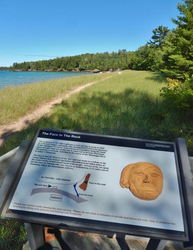
The sculpture to the right replicates a rock carving as made in 1820 by a French trapper and guide who accompanied Lewis Cass, governor of the Michigan Territory. Cass was on an expedition along the south shore of Lake Superior on his way to what . . . — — Map (db m154477) HM
Le lac supérieur the French called it, meaning only that geographically it lay above Lake Huron. In size, however, Lake Superior stands above all other freshwater lakes in the world. The intrepid Frenchman Brulé discovered it around 1622. . . . — — Map (db m41968) HM
Swedish pioneer Charles Paulson purchased one hundred acres of land here in 1884 and constructed this cabin for his family home. Built of hand hewn cedar logs securely dovetailed at the corners, the house was occupied by Paulson and his wife until . . . — — Map (db m206179) HM
The Grand Island Nishnaabe had many of their spring, summer, and fall needs met on the island, but they also visited the mainland for seasonal foods and hunting. Sand Point provided luscious cranberries. The Anna River and other streams provided . . . — — Map (db m154478) HM
AuTrain, a French term meaning "at the shortcut or traverse" was one of the earliest sites visited by white men as they travelled along Lake Superior's
south shore. The river was part of an ancient Indian route between Lakes
Supurier and . . . — — Map (db m278428) HM
Bay Furnace is all that remains of Onota, an iron-making settlement destroyed by fire in 1877.
Signs along the trail tell the story of this historic blast furnace. length: 1/8 Mile loop — — Map (db m226620) HM
Pioneer iron-makers built here because the curving shoreline and offshore islands create a protected harbor for ships. The logs you see along the beach remain from a dock that was once 1,200 feet long. The surrounding maple and beech trees . . . — — Map (db m226623) HM
Bay Furnace was abandoned in 1877. Over the next century the upper portion crumbled and the unique arches were in danger of collapse. The USDA Forest Service stabilized the remaining ruins in 1992 to prevent additional damage. "Time takes a . . . — — Map (db m226635) HM
This area was logged in the late 1800's for the large white and red pine and white cedar. Then, in the 1930's and 40's the virgin hardwoods were logged. After the initial logging era, much of the land was tax delinquent and reverted to the State of . . . — — Map (db m226638) HM
White pine, cedar, and hardwood logging led to early development of the region. The Upper Peninsula logging industry of the late 1800's and early 1900's has been romanticized in lore and story, in written and oral histories. Men like Wellington . . . — — Map (db m226824) HM
This type of anchor was in use before the discovery of America, and
was common on the Great Lakes up to the end of the sailing era. Old
sailing schooners carried them, and these boats saw many more years’
usefulness on the Great Lakes after their . . . — — Map (db m253828) HM
Grand Marais, which is among Michigan’s oldest
place names, received its name from French
explorers, missionaries, and traders who passed
here in the 1600’s. “Marais” in this case was a
term used by the voyageurs to designate a
harbor of . . . — — Map (db m253826) HM
For as much as a village is made up of its people, it is also the spaces they gather.
In 2009, a group of determined Grand Marais residents donated much time and effort and raised the funds necessary to purchase this Greenspace located in . . . — — Map (db m290702) HM
William A. Abrahamson •
Walter Aho •
Beverly Hugg •
Mark Barnly •
Francis H. Bleckiner •
Vernon L Beeckiner •
Dr. J. R. Boland •
James Buckland •
Isaac R. Carpenter •
Donald Carpenter •
Peter G. Carpenter •
Rufus Garrigan •
Forrest . . . — — Map (db m255245) WM
Pickle Barrel House.
The Pioneer Cooperage Company of
Chicago designed this small vacation
cottage, which stood on the shores
of nearby Sable Lake from 1926 until
about 1937. It was built for William
Donahey, creator of the . . . — — Map (db m253838) HM
It seems the only constant in this world is change! No two views of the Pictured Rocks cliffs are the same. Erosion by wind, water, and ice is a continuous, ongoing process.
Two good examples of change in the 20th Century include the . . . — — Map (db m226681) HM
What Does Miners Castle Mean to You?
It may depend on who you are...
Anishnabeg or Ojibwa people have lived in this area thousands of years. The Pictured Rocks cliffs hold great spiritual significance as a place where the Manitous . . . — — Map (db m226703) HM
In the Ojibwa language, Munising is "Kitchi-Minissing" or "place of the island." Grand Island, the largest on Lake Superior's south shore, has a rich history.
From here, you can see "the thumb" and the eastern side of the main portion of the . . . — — Map (db m226652) HM
Bedrock in the Lakeshore consists of three lavers of relatively soft sandstone. It overlays two-billion year old volcanic and metamorphic rocks visible at the surface to the north and west. At Marquette, quartzite, diorite, and slate are . . . — — Map (db m231031) HM
Yesterday The Schoolcraft Blast Furnace manufactured pig iron at this site for nearly ten years, beginning in 1868. Steam engines powered by water from Munising Creek provided the "blast" (hot
air) needed to turn iron ore, limestone, and . . . — — Map (db m226604) HM
With the discovery of iron ore in Marquette County in 1844 and the opening of the Sault Locks in 1855, commerce and travel boomed on Lake Superior. Munising served not only as a port, but also as a harbor of refuge during storms. The first . . . — — Map (db m143346) HM
Feb. 27 1836 – Jan. 24 1906 Brevet Major General U.S.V. Governor of Michigan Secretary of War United States Senator for whom this county is named — — Map (db m131695) HM WM
The maritime artifacts displayed in this community fountain were salvaged from the S.S. Kiowa - a steel freighter built in 1920 by the Detroit Shipbuilding Company. S.S. Kiowa measured 251 feet in length, 43 feet in beam, 24 feet in depth, . . . — — Map (db m278450) HM
Local divers Pete Lindquist, Chuck Nebel, Tom Bathey, and John Stillman recovered this large anchor found buried in the sand of Munising Bay in 1980. The anchor is estimated to weigh over 1500 pounds. The anchor may have been lost by the barque . . . — — Map (db m154896) HM
The Munising Coast Guard Station at Sand
Point opened in 1933 and closed in 1961. Photo to the right circa 1944
The official quarters building in front of you is now headquarters for
Pictured Rocks National Lakeshore.
The building . . . — — Map (db m226606) HM
In 1840, The Douglass Houghton expedition was charged with exploring the south shore of Lake Superior for the new state of Michigan. On June 13, they camped at Chapel Beach. Charles Penney, a member of the expedition, wrote in his journal...
. . . — — Map (db m312554) HM
When Pictured Rocks National Lakeshore was authorized by the U.S. Congress in 1966 as America’s first
national lakeshore, the enabling legislation called for
the construction of a “scenic shoreline drive” as part
of the park’s development. . . . — — Map (db m253843) HM
Traunik was the heart of
a large ethnic community
that developed in the early
1900s, when Slovenians
who cut timber settled on
the cut-over land. This
store, built in 1922–23,
was purchased by Louis
Mikulich in 1925. Mikulich’s
store was . . . — — Map (db m253855) HM
To this place they came, beginning in 1912, and
when enough had gathered to form a community, they
named it Traunik, which means "meadow" in Slovenia,
the country they left in search of a better life.
They brought with them a willingness . . . — — Map (db m253852) HM
This region's history is long and rich. Father Ménard, the Jesuit missionary, wintered near what is now L'Anse in 1660-1661. Near here Father Baraga set up his mission in 1843. He and the head of the neighboring Methodist mission, the Rev. J. H. . . . — — Map (db m76282) HM
Preservation of Life and Liberty.
Aalto, Waino T. •
Aalto, Eino E. •
Aaltonen, Wilhart N. •
Ahola, Alvar A. •
Ahola, Helmer L. •
Anderson, Arne A. •
Anderson, Emil E. •
Anderson, Verner A. ·•·
Beauprey, Frederick R. •
Beauprey, . . . — — Map (db m255423) WM
Completed in 1938, this
building replaced an earlier
schoolhouse destroyed by
fire in 1934. The new school
housed kindergarten through
fourth grade. Classes, first
held during the 1938-39
academic year, continued
until 1986 when L'Anse
Area . . . — — Map (db m254004) HM
After demolishing its original
hall, Covington Township
built this hall on the same
site in 1934 with support
from the Civil Works
Administration, a program
created to alleviate the Great
Depression. The Hall became
a center for community . . . — — Map (db m254002) HM
Frederic Baraga was consecrated the first Bishop of the
diocese of Sault Ste. Marie (moved and renamed in 1866 as
the diocese of Marquette) on November 1, 1853. In his first
pastoral letter, he stressed the principal and sacred
duties to be . . . — — Map (db m255542) HM
On another occasion, Baraga, with an Indian for a guide, decided to go from LaPointe to Ontonagon. He pondered the possibility of shortening the journey considerably in time and distance. Thus, he and his companion began their walk on the ice at . . . — — Map (db m255769) HM
LaPointe was the first mission Father Baraga established in
the upper region. Located on Madeline Island on the western
end of Lake Superior, it was an Indian village in which, at
times, Canadian traders resided to traffic with the Indians.
Upon . . . — — Map (db m255485) HM
Many of Baraga’s winter journeys were taken on snowshoes. This particular trip found him struggling through fierce, howling winds, deep snow, and bitter cold to reach his destination. Having traveled a great distance in the blinding storm, he . . . — — Map (db m255775) HM
So great was Baraga’s love of the Lord, it is recorded,
that he was often moved to tears during the celebration of
the Holy Mass. It is little wonder, then that his beautiful
and holy example inspired his beloved Indian children to
make for him . . . — — Map (db m255541) HM
Father Frederic Baraga's last assignment in his native
homeland was in a parish in Metlika, caring for more than
6,000 souls. His love of the Lord and his zeal for the
people were rewarded with the love the people had for
him. They responded to . . . — — Map (db m255494) HM
Another incident in Baraga’s life recalls the time when
an Indian came to him at night requesting the Blackrobe
to accompany him to his lodge to attend spiritually to
his dying mother. After providing the Indian and his dog
with food, warmth, . . . — — Map (db m255767) HM
Another time Father Baraga decided to go from LaPointe to
Grand Portage. Instead of traveling the shorelines, he rationalized
that straight voyage across the lake from Sand Island would save
80 to 100 miles as well as a month’s travel time. So, . . . — — Map (db m255673) HM
To the native Ojibwa, this area was known as Wikwedong ("“in a bay”). The French
Jesuit priest Father René Menard renamed it L’Anse de Sainte Thérèse (St.
Theresa’s Cove) in honor of his arrival on St. Theresa’s Day in 1660. Although . . . — — Map (db m254249) HM
My recollection of Bishop Baraga is rather indistinct. I remember him as a rather small, slender man
exceedingly reserved in his demeanor, and with a very sweet low voice. He was idolized by the Indians, the half-breeds, and the old voyageurs . . . — — Map (db m255501) HM
Although so many of Baraga’s missionary journeys were filled with hardships, occasionally he could relax and smile during a pleasant trip to one mission or another. Journeys taken in late summer found him filled with joy and gratitude as he . . . — — Map (db m255771) HM
Near this spot ran the L’Anse-Lac
Vieux Desert Trail, which crossed
the interior of the Upper Peninsula
of Michigan from L’Anse on Keweenaw
Bay to Lac Vieux Desert on the
Wisconsin border. The trail was
used in prehistoric times by . . . — — Map (db m254252) HM
Early Methodist missionaries
came to Kewawenon from
Sault Sainte Marie by canoe,
often a two week trip. Among
them was John Sunday, a
Chippewa, who arrived in 1832
to educate and Christianize
his fellow Indians. John Clark
came two years . . . — — Map (db m254247) HM
Native American History Links Past to Present and People with the LandAccording to traditions and historical evidence, Whitefish Bay is part of the central Anishinabeg (Ojibwe or Chippewa) homeland in the Great Lakes. Members of the nearby Bay . . . — — Map (db m154414) HM
Ice-Age glaciers covered the Whitefish Bay Area for thousands of years and left behind a complex mosaic of sand, gravel and clay. Following the last glacier's retreat about 10,000 years ago, water and wind shaped these deposits into the landscape of . . . — — Map (db m154413) HM
When the first French traders and missionaries arrived in the 1600s, the Native American Tribe called Ojibwe or Chippewa lived along the Bay. They referred to themselves in their native language as Anishinabeg, which translates as "Original People." . . . — — Map (db m154415) HM
This point of land is the historic battleground where the westward invasion by the Iroquois Indians was halted by the victorious Chippewa.
Off the point colorful French-Canadian voyageurs paddled canoes heavily laden with furs. The 18th century . . . — — Map (db m4452) HM
Unlike more remote or isolated stations surrounded by water, life at Point Iroquois included many land-based activities and contacts with neighbors. Lighthouse Service rules and regulations strongly encouraged self-sufficiency through the use of . . . — — Map (db m154409) HM
The view from the Point Iroquois Lighthouse tower includes most of Whitefish Bay shoreline, and miles out onto Lake Superior. Among the natural features, you can also see the Gros Cap Reefs Light, an unmanned buoy-type beacon in the St. Marys . . . — — Map (db m279171) HM
Side One:
Located where the St. Mary’s River enters Lake Huron from Lake Superior, DeTour Passage separates the Upper Peninsula from Drummond Island. It has long been a choke point for Great Lakes shipping. Anticipating increased traffic as a . . . — — Map (db m70781) HM
Forced by the Treaty of Ghent to
evacuate the fort they had captured on
Mackinac Island during the War of 1812,
the British selected this island as an
alternate military post. The stronghold
was close to the traditional Indian
gathering point . . . — — Map (db m253761) HM
Anchor from the SS M.M. Drake
on loan from the State of
Michigan. The Drake (constructed
in 1882) was a wooden steam barge
that towed consorts loaded with
coal and iron ore on the Great
Lakes. The Drake sank on
October 6, 1901 . . . — — Map (db m214015) HM
In memory of
Donald "Bud” Monk
Math Teacher & Principal
1948-1979
"He knew every brick in this school"
Original School Bell from Porcupine School in Whitefish Township 1942 — — Map (db m214014) HM
Once a thriving hub of pine lumbering, Emerson is now a fishing hamlet. Just one mile south of the mouth of the Tahquamenon River (immortalized in Longfellows poem “Hiawatha”), this settlement overlooks picturesque Whitefish Bay. The village was . . . — — Map (db m213408) HM
Whitefish Point has been called the graveyard of Lake Superior. Since navigation began on Lake Superior there has been approximately 550 wrecks. More vessels were lost in the Whitefish Point area than any other part of Lake Superior. There are three . . . — — Map (db m198451) HM
This post office opened just six years after Whitefish Point was settled in 1871 as a landing for the then-abundant lumber supplies and as a commercial fishery. Permanent residents received their mail from Sault Ste. Marie. During the summer . . . — — Map (db m213445) HM
This light, the oldest active on Lake Superior, began operating in 1849, though the present tower was constructed later. Early a stopping place for Indians, voyageurs, and Jesuit missionaries, the point marks a course change for ore boats and other . . . — — Map (db m40054) HM
In 1849 the Whitefish Point lighthouse was put into service. Soon after the township was organized in 1888, lumber towns such as Emerson and Shelldrake emerged at the mouth of the Tahquamenon and Shelldrake rivers. Paradise was established in . . . — — Map (db m214012) HM
The line in the center of this plaque marks its location.
This Michigan Meridian runs north
from the initial point located near
Leslie, between Jackson and Lansing.
It is the dividing line between east
and west ranges in the State . . . — — Map (db m278209) HM
This statue depicts the Chippewa legend of two young brothers who flee their wicked mother who is pursuing them with the intent to kill them. When they reach the north shore of the St. Mary's Rapids they are met by a crane. Who after hearing . . . — — Map (db m213641) HM
This statue is an exact replica of the original which stands in the Capitoline Museum of Rome, Italy. The statue depicts the Roman legend of twin sons of a vestal virgin. Romulus and Remus, who were abandoned by their mother to die. They were . . . — — Map (db m213635) HM
Do they rub the lock walls?
The Poe Lock is 1,200 feet long and 110 feet wide. Every footer is 105 feet wide. When entering the
lock captains like to come in tight to the north wall while keeping as much space open on the other
side as . . . — — Map (db m255229) HM
Do they go to the Atlantic Ocean?
Footers cannot go beyond Lake Erie and Lake Michigan. The locks in the Welland Canal, bypassing Niagara Falls to connect Lakes Erie and Ontario, cannot take vessels over 740 feet long and 78 feet wide. Locks . . . — — Map (db m224379) HM
Do they lock through often?
Footers make regular runs between loading docks on Lake Superior and the harbors large enough to serve them on the lower lakes. Most are through the locks about every three days, carrying millions of tons of iron ore . . . — — Map (db m224382) HM
How do they steer those boats?
From several stories above the water the captain has a bird's-eye view of the deck but relies on
constant reports from mates at the bow and stern to know the exact position of the vessel when
operating in close . . . — — Map (db m255225) HM
Do they sail year-round?
Boats depend on the Soo Locks to travel between ports on Lake Superior and the lower lakes. Each
year when the locks close January 15, footers head to ports and shipyards around the lakes for
maintenance before the . . . — — Map (db m255232) HM
How much can they carry?
Depending on the design of their cargo holds and unloading gear, footers can carry between
58,000 and 80,900 tons in a single load. It would take up to 3,000 semi trucks or 700 rail cars to carry that same load! — — Map (db m255221) HM
How big is a 1,000-foot-long boat?
Imagine yourself standing at the stern of one of these boats.
Following the arrows walk from the stern to bow and learn more about each of the thirteen footers operating on the Great Lakes along the way. — — Map (db m224384) HM
Do they live on board?
Crew size on Great Lakes freighters averages around 22 people who live and work on board for
several weeks at a time. The crew enjoy excellent food, private quarters, air conditioning and have
access to Wi-Fi and . . . — — Map (db m255223) HM
You reached the bow!
It's a long way from the bow to the stern of the thirteen-footers on the Great Lakes. The Paul R. Tregurtha is the biggest of them all, giving her the title “Queen of the Great Lakes.” — — Map (db m224373) HM
A 1,000-foot-long tug boat?
The Presque Isle is the only integrated tug/barge footer. It was designed to operate with the smaller crew of a tug boat and the cargo capacity of a footer. After sea trials, the U.S. Coast Guard determined the . . . — — Map (db m224378) HM
Why does only one have a forward pilothouse?
The first footer, the Cort, is the only one with a forward pilothouse. The twelve footers that followed placed all accommodations and the pilot house at the stern saving hundreds of thousands of . . . — — Map (db m224381) HM
How do they unload?
All footers on the Great Lakes are self-unloaders with conveyor belt systems below the cargo
holds. The belts carry materials to the deck where they are unloaded off the side using either
deck-mounted booms or shuttle . . . — — Map (db m255227) HM
It is impossible on a panel this size to give a comprehensive sample of the types of vessels that have plied the St. Marys River over the centuries. This one features larger boats of the last 150 years.
The Wilfred Sykes, launched in 1949, . . . — — Map (db m214150) HM
Halfway there!
You have now made it approximately halfway. Think of how far you have already walked and imagine being a deckhand responsible for painting or shoveling the deck of a boat 1,000 feet long and 105 feet wide! — — Map (db m224380) HM
Anishinaabek oral history relates that long ago Gchi-Manito (Creator) sent a bird to make its abode on the earth. This bird, Ajiijaak, (crane) circled the land and saw the abundance of Adikameg (whitefish) and after coming to rest on Wadjiwong (a . . . — — Map (db m214152) HM
Sault Ste. Mire, including the campus of Lake Superior State University is steeped in a rich history originating as a natural gathering place for Native Peoples who refer to the Sault Rapids area as "Bahweting."
This copper sculpture was created . . . — — Map (db m214251) HM
Built in 1939, Brady Hall was a US Army
barracks when the campus was still
Fort Brady. The building is named in
honor of Major General Hugh Brady,
who first established Fort Brady along
the St. Mary's River in 1822. The
barracks were converted . . . — — Map (db m213628) HM
This building, formerly headquarters of Fort Brady, is named Brown Hall in honor of Edward J. Brown. At the time of his retirement in August, 1971, Mr. Brown compiled the longest service on what is now this campus. He started with the Post Engineer, . . . — — Map (db m214250) HM
This Richardsonian Romanesque church was erected in 1892-93 according to plans by Bay City architect Dillon P. Clark. It is one of several builldings in the city constructed of red "canal rubble" sandstone discarded during a power canal . . . — — Map (db m213409) HM
Chippewa County Court House has been placed on the National Register of Historic Places by the United States Department of the Interior
1877 — — Map (db m213645) HM
The Chippewa County Courthouse, a part of which can be seen when looking east down the walkway, has been in continuous use since it was constructed in 1877, making it the oldest operational courthouse in Michigan. Designed by John Scott, it is an . . . — — Map (db m214226) HM
In honor and remembrance of those who served in the armed forces of the United States
Korea
Raymond W. Anderson • Wesley A. Anderson • Raymond J. Bedore • William A. Bunner • Lucien J. Bourque Jr. • Albert J. Dumback • Ronald A. Earl • . . . — — Map (db m214223) WM
Dedicated to those who gave their lives in World War II in the cause of all freedoms
Aikens Russell C. ·
Allen George S. ·
Ames Charles W. ·
Anderson, John C. ·
Armstrong, Clyde ·
Atkins, Floyd ·
Barber William · . ·
Barrus George . . . — — Map (db m214173) WM
The row houses were built between 1900-1903 to house commissioned officers and their families when the Lake Superior State University campus was still serving as US Army Fort Brady. Over the years, the buildings have housed campus faculty, staff and . . . — — Map (db m214242) HM
The man-made power canal that bisects the city of Sault Ste. Marie was constructed from 1898 to 1902. The flow of water from the upper St. Mary's river through the canal still generates electricity at the Edison Sault hydroelectric plant, also . . . — — Map (db m214229) HM
The Weitzel Lock was the first at the Sault to fill and empty the lock chamber using valves built into the floor. The easier State Lock moved water through opening in the gates creating turbulence in the chamber. The churning waters in the lock made . . . — — Map (db m214168) HM
This was the scene in Sault Ste. Marie about 1910 looking
north up Ashmun Street toward Spruce Street from this
kiosk location. Ashmun street was not yet paved and
utility poles lined its edges. Trolley cars and horse drawn
vehicles provided . . . — — Map (db m213634) HM
By the mid-1830s, there were at least two hotels on Water Street. One, known for a time as the Van Anden House and later as the Chippewa House, was on the southeast corner of Water and present day Ashmun streets. The other eventually became the . . . — — Map (db m214154) HM
Built in 1893, East Hall is one of 19
remaining Fort Brady buildings left on
campus. It was originally the Fort Brady
jail and guardhouse. After the fort closed
in 1946, the building was renamed
East Hall and housed the music program
at . . . — — Map (db m213463) HM
The row houses were built between
1900-1903 to house commissioned officers
and their families when the Lake Superior
State University campus was still serving
as US Army Fort Brady. Over the years,
the buildings have housed campus . . . — — Map (db m213631) HM
Appointed Indian agent in 1822, Henry Rowe Schoolcraft (1793-1864) requested that the government provide a suitable structure to house the agency. Obed Wait, designer of Michigan's territorial capitol in Detroit, directed the construction of this . . . — — Map (db m213411) HM
558 entries matched your criteria. The first 100 are listed above. Next 100 ⊳